
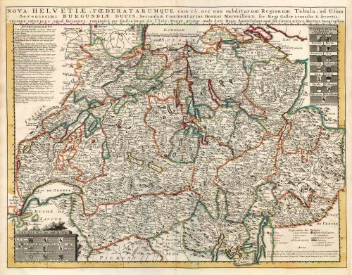
Switzerland by Guillaume Delisle, published by Covens & Mortier. 1730

Covens & Mortier. A Map Publishing House in Amsterdam. 1721-1866.
For almost two centuries, the Amsterdam firm of Covens & Mortier was the most significant and crucial Dutch publishing house in commercial cartography. In terms of quantity, it was the biggest contemporary map-trading house worldwide, distributing innumerable maps, atlases, globes, and books.
Pieter (Pierre) Mortier (Leiden, 1661 – Amsterdam, 1711)
Nothing is known about the youth of Pieter Mortier. He studied in Paris from 1681 to approximately 1685. He must have come into contact with French 'libraires' and learned the bookselling trade there. In 1685, he returned to Amsterdam and opened a small bookshop. He joined the Book, Art Sellers' and Printers' Guild the same year.
Pieter sold books in Dutch and foreign languages but also published books himself, usually in French. His business flourished so much that in 1688, he was forced to rent another house on the Vijgendam.
Pieter Mortier's first privilege for maps was granted by the States of Holland and West Friesland on September 15, 1690. It refers to Sanson's maps, which he 'is printing and correcting with great pains and care'.
Pieter began publishing maps and atlases on a large scale. By the beginning of the 18th century, he had become so wealthy that he could purchase three houses in Amsterdam: the Beurssluis, on the Vijgendam, and the Heremietensteeg. He rebuilt the Vijgendam house into a large, prestigious structure that would serve for over a century as a shop, business, and residential structure for Covens & Mortier's publishing house.
He died on February 13, 1711, after a brief illness. The company continued under the management of Pieter's widow, Amelia' s-Gravesande.
After she died in 1719, her son, Cornelis, took over the management for a few years.
On November 20, 1721, a company was founded by Cornelis Mortier and Johannes Covens I. The latter was married the same year to Cornelis's sister. From that year on, the name of :
Covens & Mortier.
Their firm would see a massive expansion in the next 140 years. In 1732, the heirs sold the property to their brother Cornelis and his partner Covens. Their main competitors were Reinier & Josua Ottens and Gerard Valck & Petrus Schenck. After the death of Johannes Covens I (1774), his son Johannes Covens II (1722-1794) entered the business. In 1778, Johannes added a new company name :
J. Covens & Son.
Johannes Covens II was succeeded by his son Cornelis Covens (1764-1825), who, in turn, brought Peter Mortier IV, the great-grandson of Petrus Mortier I, into the business. The name was from 1794 to 1866:
Mortier, Covens & Son.
The last Covens in the series was Cornelis Johannes Covens (1806-1880).
Covens & Mortier had a large stock of atlases and maps, including Delisle, Jaillot, Johannes Janssonius, Sanson, and Claes Jansz. Visscher, Nicolaas Visscher, and Frederik de Wit. For decades, the press produced an impressive number of atlases.
Guillaume Delisle (Paris, 1675 – 1726)
Guillaume Delisle (de L’Isle), one of the key figures in the development of French cartography, is the son of Claude Delisle, a cartographer, and the half-brother of astronomers Joseph-Nicolas Delisle and Louis de l'Isle de la Croyère.
While his father has to be given credit for educating Guillaume, the boy showed early signs of being an exceptional talent. He soon contributed to the family workshop by drawing maps for his father's historical works. To perfect his skills, Guillaume Delisle became the student of the astronomer Jean-Dominique Cassini. Early on, he produced high-quality maps, the first being his Carte de la Nouvelle-France et des Pays Voisins in 1696. Delisle's first atlas appeared around 1700, and in 1702 he became a member of the French Académie Royale des Sciences. He taught geography to the young Louis XV, and in 1718 he received the title of Premier Géographe du Roi. On a commission from Peter the Great, he produced a map of the Caspian Sea, a region barely known. Many of the place names he gave are still in use. His Carte de la Louisiane et du cours du Mississippi (1718) is the first detailed map of this region.
A six-year-long plagiarism trial pits Delisle against Jean-Baptiste Nolin, cartographer. It is Nolin, the real plagiarist, who loses.
Delisle has remained famous for his astronomical-based corrections and the completeness of its topography. The high scientific quality of the work produced by the Delisle family contrasted with the workshop of Sanson. While Sanson knowingly published outdated facts and mistakes, Delisle constantly updated his maps to reflect widening knowledge of the world.
Nova Helvetiae, Foederatarumque cum ea, nec non Subditarum Regionum Tabula ...
Item Number: 25699 Authenticity Guarantee
Category: Antique maps > Europe > Switzerland
Old, antique map of Switzerland by Guillaume Delisle, published by Covens & Mortier.
Title: Nova Helvetiae, Foederatarumque cum ea, nec non Subditarum Regionum Tabula ...
Copper engraving, printed on paper.
Size (not including margins): 470 x 610mm (18.5 x 24.02 inches).
Verso: Blank.
Condition: Original coloured in outline, excellent.
Condition Rating: A+.
References: Blumer (Schweiz), #181
From: Atlas Nouveau ... Par Guillaume de l'Isle ... Amsterdam, Covens & Mortier, 1730.
Covens & Mortier. A Map Publishing House in Amsterdam. 1721-1866.
For almost two centuries, the Amsterdam firm of Covens & Mortier was the most significant and crucial Dutch publishing house in commercial cartography. In terms of quantity, it was the biggest contemporary map-trading house worldwide, distributing innumerable maps, atlases, globes, and books.
Pieter (Pierre) Mortier (Leiden, 1661 – Amsterdam, 1711)
Nothing is known about the youth of Pieter Mortier. He studied in Paris from 1681 to approximately 1685. He must have come into contact with French 'libraires' and learned the bookselling trade there. In 1685, he returned to Amsterdam and opened a small bookshop. He joined the Book, Art Sellers' and Printers' Guild the same year.
Pieter sold books in Dutch and foreign languages but also published books himself, usually in French. His business flourished so much that in 1688, he was forced to rent another house on the Vijgendam.
Pieter Mortier's first privilege for maps was granted by the States of Holland and West Friesland on September 15, 1690. It refers to Sanson's maps, which he 'is printing and correcting with great pains and care'.
Pieter began publishing maps and atlases on a large scale. By the beginning of the 18th century, he had become so wealthy that he could purchase three houses in Amsterdam: the Beurssluis, on the Vijgendam, and the Heremietensteeg. He rebuilt the Vijgendam house into a large, prestigious structure that would serve for over a century as a shop, business, and residential structure for Covens & Mortier's publishing house.
He died on February 13, 1711, after a brief illness. The company continued under the management of Pieter's widow, Amelia' s-Gravesande.
After she died in 1719, her son, Cornelis, took over the management for a few years.
On November 20, 1721, a company was founded by Cornelis Mortier and Johannes Covens I. The latter was married the same year to Cornelis's sister. From that year on, the name of :
Covens & Mortier.
Their firm would see a massive expansion in the next 140 years. In 1732, the heirs sold the property to their brother Cornelis and his partner Covens. Their main competitors were Reinier & Josua Ottens and Gerard Valck & Petrus Schenck. After the death of Johannes Covens I (1774), his son Johannes Covens II (1722-1794) entered the business. In 1778, Johannes added a new company name :
J. Covens & Son.
Johannes Covens II was succeeded by his son Cornelis Covens (1764-1825), who, in turn, brought Peter Mortier IV, the great-grandson of Petrus Mortier I, into the business. The name was from 1794 to 1866:
Mortier, Covens & Son.
The last Covens in the series was Cornelis Johannes Covens (1806-1880).
Covens & Mortier had a large stock of atlases and maps, including Delisle, Jaillot, Johannes Janssonius, Sanson, and Claes Jansz. Visscher, Nicolaas Visscher, and Frederik de Wit. For decades, the press produced an impressive number of atlases.
Guillaume Delisle (Paris, 1675 – 1726)
Guillaume Delisle (de L’Isle), one of the key figures in the development of French cartography, is the son of Claude Delisle, a cartographer, and the half-brother of astronomers Joseph-Nicolas Delisle and Louis de l'Isle de la Croyère.
While his father has to be given credit for educating Guillaume, the boy showed early signs of being an exceptional talent. He soon contributed to the family workshop by drawing maps for his father's historical works. To perfect his skills, Guillaume Delisle became the student of the astronomer Jean-Dominique Cassini. Early on, he produced high-quality maps, the first being his Carte de la Nouvelle-France et des Pays Voisins in 1696. Delisle's first atlas appeared around 1700, and in 1702 he became a member of the French Académie Royale des Sciences. He taught geography to the young Louis XV, and in 1718 he received the title of Premier Géographe du Roi. On a commission from Peter the Great, he produced a map of the Caspian Sea, a region barely known. Many of the place names he gave are still in use. His Carte de la Louisiane et du cours du Mississippi (1718) is the first detailed map of this region.
A six-year-long plagiarism trial pits Delisle against Jean-Baptiste Nolin, cartographer. It is Nolin, the real plagiarist, who loses.
Delisle has remained famous for his astronomical-based corrections and the completeness of its topography. The high scientific quality of the work produced by the Delisle family contrasted with the workshop of Sanson. While Sanson knowingly published outdated facts and mistakes, Delisle constantly updated his maps to reflect widening knowledge of the world.
Related items
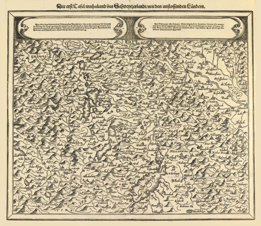
Die erst Tafel innhaltend das Schweytzerlandt mit den anstossenden Ländern. 1588
Switzerland by Sebastian Münster.
[Item number: 14631]

Helvetia Prima Rheni et V Nova Tabula. 1542
Switzerland by Sebastian Munster.
[Item number: 14925]

Exactissima Helvetiae Rhaetiae, Valesiae ... 1683-1696
Switzerland, by Visscher N.
[Item number: 18692]

Decem et Tria Loca Confoederatorum Helvetiae. 1572
13 bird's-eye views of Swiss cities by Braun and Hogenberg: Schwyz, Unterwalden, Zug, Glarus, Basel, Zurich, Bern, Lucerne, Uri, Fribourg, Solothurn, Schaffhausen and Appenzell.
[Item number: 21654]

Helvetia Tredecim Statibus Liberis quos Cantones vocant Composita ... c. 1757.
Switzerland, by Homann Heirs.
[Item number: 22480]

Helvetiae Descriptio Aegidio Tschudo Auct. 1612
Switzerland, by Ortelius A.
[Item number: 22945]

Helvetiae Descriptio Aegidio Tschudo Auct. 1579
SWITZERLAND by Abraham Ortelius
[Item number: 23164]

Decem et Tria Loca Confoederatorum Helvetiae. 1572-1624
13 bird's-eye views of Swiss cities by Braun and Hogenberg: Schwyz, Unterwalden, Zug, Glarus, Basel, Zurich, Bern, Lucerne, Uri, Fribourg, Solothurn, Schaffhausen and Appenzell.
[Item number: 23230]

Novissima et Acuratissima Helvetiae, Rhaetiae, Valesiae et Partis Sabaudiae Tabula 1756
Antique map of Switzerland by Ottens R. & J.
[Item number: 23506]

La Suisse. 1713
Switzerland, by Pieter Van der Aa.
[Item number: 26174]

Helvetia cum finitimis regionibus confoederatis. 1641
Switzerland, by Henricus Hondius
[Item number: 26292]

La Suisse Divisee en ses Treize Cantons et ses Allies. 1776-79
Switzerland, by Francesco Santini.
[Item number: 26957]

Helvetia cum finitimis regionibus confoederatis. 1623
Switzerland, by Gerard Mercator.
[Item number: 27884]

Nova Helvetiae Tabula. c. 1634
Switzerland, by Jodocus Hondius.
[Item number: 28003]

Ta . Here . Helve. [From verso] 1525
Switzerland by Lorenz Fries.
[Item number: 28199]

Helvetia Divisa in Tredicem Cantones sive Regiones, Bernam nempe Fruburgum, Solodurum, Basileam, Schafhusiam; Tigurum et Lucernam, cum foederatis Regionibus, numirum Comitatu Neoburgensi, urbe Biela, Resp. Genevensi Abbatia S. Galleni et Vallesia. c. 1702
Switzerland by Gerard & Leonard Valck.
[Item number: 28270]

Helvetiae Rhetiae & Valesiae cum omnibus finitimis regionibus Tabula Vulgo Schweitzerland. c. 1678
Switzerland by Johannes Janssonius.
[Item number: 28538]

Carte Générale des treize Cantons Suisse, et des différents Etats de leur Dépendance; ainsi que la pluspart des Etats qui leur sont voisins et aliez; avec des tables pour l'intelligence de l'Histoire. 1708
Switzerlandx, by Zacharias Châtelain.
[Item number: 29444]

La Suisse divisée en ses Treze Cantons, Ses Alliez & Ses Sujets, c. 1709
Switzerland by Hubert Jaillot, published by Pierre Mortier.
[Item number: 29566]

Helvetia cum finitimis Regionibus confoederatis. 1643
Switzerland by Willem Blaeu.
[Item number: 29928]

Affligenium Vulgo Affligem Primaria ac nobilissima in Ducatu Brabantiae, ordinis S. Benedicti Abbatia. 1726
Benedictine Abbey of Affligem, by Antonius Sanderus.
[Item number: 30779]
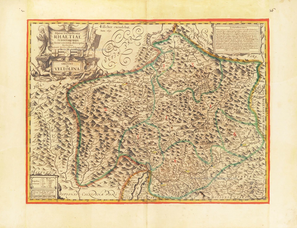
The first modern map of the Canton of Graubunden.
Alpinae seu foederatae Rhaetiae subdirarumque ei Terrarum nova descriptio. Grisons en Veltolina. 1630
Italian and Swiss Alps by C.J. Visscher, after Philipp Cluverius.
[Item number: 30936]
new

Very rare.
Raetiae veteris et exterae pars Orientalis, qua Comitatus Tyrolis cum Regionibus finitimis, continetur. 1616
Switzerland - Eastern Rhaetia by Matthias Hirtzgarter.
[Item number: 31190]

Helvetia. 1618
Switzerland by Petrus Bertius, published by Jodocus Hondius II.
[Item number: 31585]

L'Elvezia divisa ne suoi tredici cantoni e suoi Alleati 1779-1785
Switzerland, by Antonio Zatta.
[Item number: 31893]

Parte Occidentale dell' Elvezia Divisa ne' suoi Cantoni [and] Parte Orientale dell' Elvezia 1779-1785
Switzerland in two maps, by Antonio Zatta.
[Item number: 31894]

La Suisse. 1633
Switzerland by Christophe Tassin.
[Item number: 32007]

La Suisse divisée en ses Treze Cantons, Ses Alliez & Ses Sujets, 1692
Switzerland by Nicolas Sanson, published by Hubert Jaillot.
[Item number: 32294]

Potentissimae Helvetiorum Reipublicae Cantones Tredecim cum Foederatis et Subjectis Provinciis c. 1720
Switzerland, by J.B. Homann.
[Item number: 32406]

Helvetiorum Reipublicae Cantones XIII; ut et Faederata Rhaetia; Quique Iis Cocii, ac Subditi: Adkunctis una Comitatibus Vallesiae, et Neocomi/ c. 1696-1700
Switzerland, by Gerard Valk.
[Item number: 32503]

Tabula Geographica qua pars Meridionalis sive Superior Rheni, Mosae, et Mosellae, ac minores influentes Fluvii nec non mediae partes Archiepiscopatus et Electoratus Moguntini et Palatinatus Rheni, Lotharingia Helvetia Alsatia Suevia Ducatus et Comitatus Burgindiae, aliaque Galliae et Italiae 1683-1702
Switzerland, Eastern France, and south-western Germany, by N. Visscher
[Item number: 32630]

L' Helvetia o Paese de Suizzeri con li Stati, che sono à medesimi collegati, e sogetti 1686
Switzerland by Giacomo Cantelli da Vignola, published by Giovanni de Rossi.
[Item number: 32901]