
Antique map of Africa by Ottens R. & J. 1756

The Ottens Family
Joachim Ottens (1663-1719), was a copper-engraver and the founder of the print- and mapsellers’ firm in Amsterdam. In 1710 he became a member of the art- and printsellers guild. After he died in 1719, his widow and the sons continued the business under the name “In de Wereldcaert” (In the world map). On the whole, the Ottens’s financial position was rather weak, and the stock was not very large.
In a notary contract dated 20 October 1726, the partnership between the two brothers, Reinier and Josua, was stipulated. Despite separate shops, the brothers’ partnership continued until the death of Renier in 1750.
After Joshua died in 1765, his widow continued the firm, together with her son, Renier II, until c. 1780.
The firm flourished mainly between 1719 and c. 1750. In that period, they advertised at various times the publication of new maps.
Ottens’s greatest fame comes from the voluminous atlases assembled to order. A small number of these so-called ‘Atlas factice’, splendid copies with gorgeous illumination, have survived. These collector’s copies are known to exist in 2, 6, 8, 11, and even 15 volumes. Ottens also published atlases in one volume, with a varying number of maps, pocket atlases, collections of military plans, and Renard’s atlas de la navigation.
L'Afrique Divisee en ses Empires, Royaumes et Etats
Item Number: 23524 Authenticity Guarantee
Category: Antique maps > Africa
Africa by Ottens R. & J.
Title: L'Afrique Divisee en ses Empires, Royaumes et Etats
Oriented to the northwest.
Date: 1756.
Copper engraving, printed on paper.
Image size: 460 x 590mm (18.11 x 23.23 inches).
Sheet size: 520 x 630mm (20.47 x 24.8 inches).
Verso: Blank.
Condition: Original coloured, lower centrefold reinforced, light browning along centrefold.
Condition Rating: B.
From: Atlas minor sive geographia compendiosa in qua orbid terrarum paucis attamen novissimis tablulis ostenditur - Atlas nouveau contenant toutes les parties du monde où sont exactement remarquées les empires, monarchies, royaumes,états, républiques, &c. Amsterdam, R. & J. Ottens (1756). (Koeman, Ott3)
The Ottens Family
Joachim Ottens (1663-1719), was a copper-engraver and the founder of the print- and mapsellers’ firm in Amsterdam. In 1710 he became a member of the art- and printsellers guild. After he died in 1719, his widow and the sons continued the business under the name “In de Wereldcaert” (In the world map). On the whole, the Ottens’s financial position was rather weak, and the stock was not very large.
In a notary contract dated 20 October 1726, the partnership between the two brothers, Reinier and Josua, was stipulated. Despite separate shops, the brothers’ partnership continued until the death of Renier in 1750.
After Joshua died in 1765, his widow continued the firm, together with her son, Renier II, until c. 1780.
The firm flourished mainly between 1719 and c. 1750. In that period, they advertised at various times the publication of new maps.
Ottens’s greatest fame comes from the voluminous atlases assembled to order. A small number of these so-called ‘Atlas factice’, splendid copies with gorgeous illumination, have survived. These collector’s copies are known to exist in 2, 6, 8, 11, and even 15 volumes. Ottens also published atlases in one volume, with a varying number of maps, pocket atlases, collections of military plans, and Renard’s atlas de la navigation.
Related items

Africa Tertia Pars Terrae. 1581
Africa, by H. Bünting.
[Item number: 26228]

Big and beautiful map.
L'Afrique Selon les Nouvelles Observations de Messrs. de l'Academie des Sciences, etc. Before 1713
Africa, by François Halma.
[Item number: 27853]
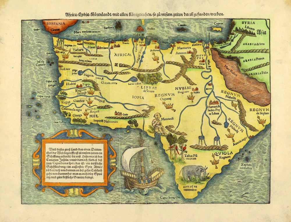
Africa / Lybia / Morenland / mit allen Künigreichen / so zu unsern zeiten darin gefunden werden. 1572
Africa by Sebastian Münster.
[Item number: 28142]

Africae Accurata Tabula. 1656-77
Africa by Nicolaes Visscher I.
[Item number: 28551]

Africa Ex magna orbis terre. 1623
Africa by Gerard Mercator.
[Item number: 28678]

Totius Africae Accuratissima Tabula, c. 1697-1704
Africa, by Frederick De Wit.
[Item number: 29289]

Important map
Presbiteri Iohannis, sive, Abissinorum Imperii Descriptio. 1584
Prestor John Map (Western & Central Africa), by Abraham Ortelius.
[Item number: 29722]

Dr David Livingstone
Map of the River Shire, The Lakes Nyassa, & Shirwa, The Lower Courses of the Rivers Zambesi & Rovuma.
South Eastern Africa by Dr D. Livingstone.
[Item number: 29939]
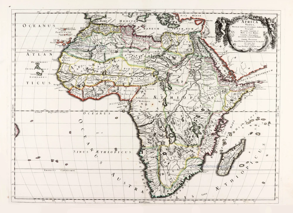
Africa Vetus. 1667-69
Ancient Africa by Nicolas & Guillaume Sanson.
[Item number: 30003]

Important map
Africae Tabula Nova. 1575
Africa by Abraham Ortelius
[Item number: 30948]