
(Middle Atlantic) by Pierre Mortier 1700
Cartographically, this chart is based mainly on the crucial and rare Augustine Herrman map. The map provides exceptional detail of the waterways, including soundings, navigational hazards, and coastal communities. Philadelphia is prominently shown. The chart was prepared by Alexis-Hubert Jaillot and appeared in the atlas Suite du Neptune Francois in 1700 and Atlas Nouveau in 1708, published by Pierre Mortier, whose imprint is in the distance scale at the lower left.
Alexis-Hubert JAILLOT (1632-1712)
A.-H. Jaillot first started as a sculptor. In 1664 he married Jeanne Berey, daughter of the publisher and dealer of prints Nicolas I Berey. Jaillot soon rushed into the print business due to his father-in-law's deaths in 1665 and his brother-in-law in 1667. In 1668, A.-H. Jaillot and his wife acquire the Berey fund's geographical part, which consists of globes, maps, city views and atlases. He becomes the tenant of his father-in-law's shop, Aux Deux Globes, which he buys two years later.
Jaillot enters into an agreement with Guillaume Sanson to publish his maps that will form his Atlas Nouveau's embryo. Sanson undertakes to obtain the privilege for his maps for twenty years and to cede it to Jaillot, as is the custom. Jaillot, for its part, takes care of the engraving, printing and sale of the maps. He engages engravers, François Caumartin and Louis Cordier, to engrave his maps.
A conflict arises between Jaillot and Sanson, and in 1674 it comes to a lawsuit. In 1677 they came back to an agreement.
The Atlas Nouveau first appeared in 1681 and brought great prosperity to his publisher. Jaillot owes him his title of the geographer to the king, awarded on July 20, 1686. He continues to issue maps and signs more and more himself. In 1695, he published the Atlas Français, two-thirds of which are his maps and only one third by Sanson.
A.H. Jaillot dies in 1712 and leaves a vast trading fund.
Covens & Mortier. A Map Publishing House in Amsterdam. 1721-1866.
For almost two centuries, the most significant and crucial Dutch publishing house in commercial cartography was the Amsterdam firm of Covens & Mortier. Concerning quantity, it was the biggest contemporary map-trading house worldwide. They distributed innumerable maps, atlases, globes, and books.
Pieter (Pierre) Mortier (Leiden, 1661 – Amsterdam, 1711)
Nothing is known about the youth of Pieter Mortier. He studied in Paris from 1681 to approximately 1685. He must have come into contact with French 'libraires' and learned the bookselling trade there. In 1685, he returned to Amsterdam and opened a small bookshop. He joined the Book, Art Sellers' and Printers' Guild in the same year.
Pieter sold books in Dutch and foreign languages, but he also published books on his own, usually in French. His business flourished so much that in 1688, he was forced to rent another house on the Vijgendam.
Pieter Mortier's first privilege for maps was granted by the States of Holland and West Friesland on September 15 1690. It refers to the maps of Sanson that he 'is printing and correcting with great pains and care'.
Pieter began the large-scale publication of maps and atlases. By the beginning of the 18th century, Pieter had become so wealthy that he could purchase three houses in Amsterdam: the Beurssluis, on the Vijgendam, and the Heremietensteeg. He rebuilt the house on the Vijgendam into a large, prestigious house that would serve for over a century as a shop, business, and residential structure for Covens & Mortier's publishing house.
He died on February 13, 1711, after a brief illness. The company continued under Pieter's widow's management, Amelia' s-Gravesande.
After she died in 1719, her son, Cornelis, took over the management for a few years.
On November 20, 1721, a company was founded by Cornelis Mortier and Johannes Covens I. The latter was married the same year to Cornelis's sister. From that year on, the name of :
Covens & Mortier.
Their firm would see a massive expansion in the next 140 years. In 1732, the heirs sold the property to their brother Cornelis and his partner Covens. Their main competitors were Reinier & Josua Ottens and Gerard Valck & Petrus Schenck. After the death of Johannes Covens I (1774), his son Johannes Covens II (1722-1794) entered the business. In 1778, Johannes added a new company name :
J. Covens & Son.
Johannes Covens II was succeeded by his son Cornelis Covens (1764-1825), who, in turn, brought Peter Mortier IV, the great-grandson of Petrus Mortier I, into the business. The name was from 1794 to 1866:
Mortier, Covens & Son.
The last Covens in the series was Cornelis Johannes Covens (1806-1880).
Covens & Mortier had a large stock of atlases and maps, including Delisle, Jaillot, Johannes Janssonius, Sanson, and Claes Jansz. Visscher, Nicolaas Visscher, and Frederik de Wit. For decades, an impressive number of atlases came from the press.
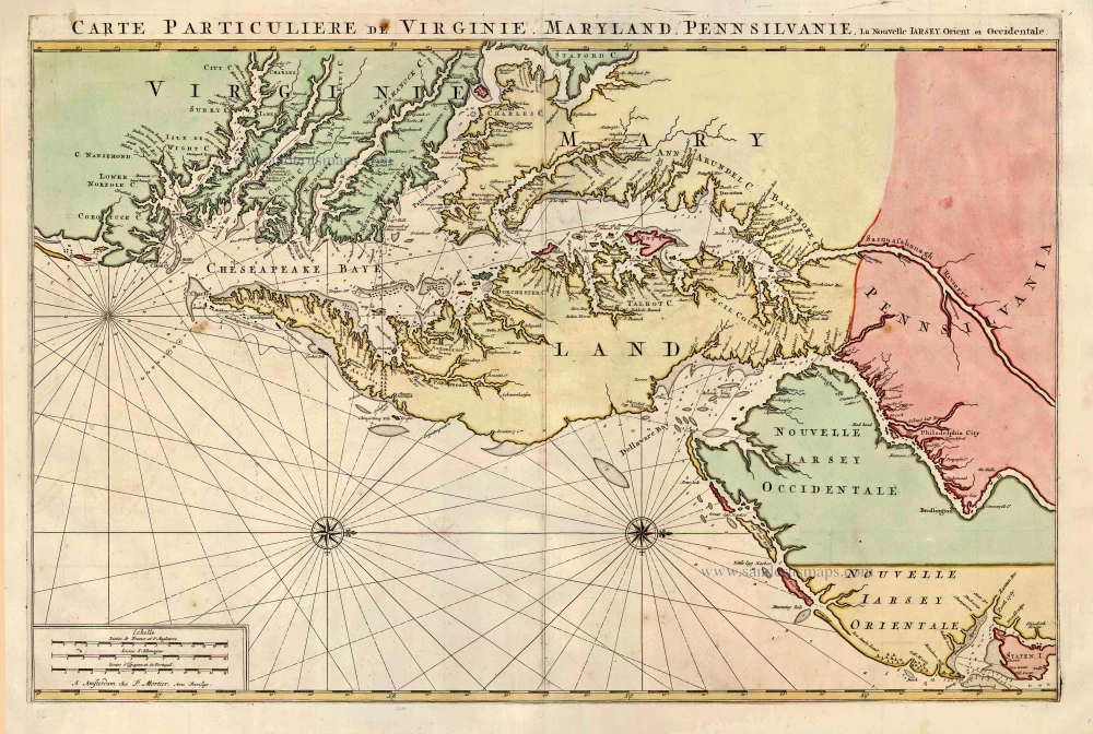
Carte Particuliere de Virginie, Maryland, Pennsilvanie, la Nouvelle Iarsey Orient et Occidentale.
Item Number: 27649 Authenticity Guarantee
Category: Antique maps > America > North America
Large scale chart showing Mary Land and Chesapeake Bay, by A.H. Jaillot, published by Pierre Mortier.
Title: Carte Particuliere de Virginie, Maryland, Pennsilvanie, la Nouvelle Iarsey Orient et Occidentale.
Oriented to the west.
Cartographer: A.H. Jaillot.
Date: 1700
Copper engraving, printed on paper.
Map size: 540 x 805mm (21.26 x 31.69 inches).
Sheet size: 955 x 630mm (37.6 x 24.8 inches).
Verso: Blank.
Condition: Original body colour, excellent.
Condition Rating: A+.
References: Koeman IV, M. Mor7 (31); Pastoureau, Jaillot I, F, 365; Shirley (Brit. Lib.), T.MORT-1a, 15
From: Suite du Neptune François, ou Atlas Nouveau des Cartes Marines. Amsterdam, Pierre Mortier, 1700. (Koeman IV, M.Mor7)
Cartographically, this chart is based mainly on the crucial and rare Augustine Herrman map. The map provides exceptional detail of the waterways, including soundings, navigational hazards, and coastal communities. Philadelphia is prominently shown. The chart was prepared by Alexis-Hubert Jaillot and appeared in the atlas Suite du Neptune Francois in 1700 and Atlas Nouveau in 1708, published by Pierre Mortier, whose imprint is in the distance scale at the lower left.
Alexis-Hubert JAILLOT (1632-1712)
A.-H. Jaillot first started as a sculptor. In 1664 he married Jeanne Berey, daughter of the publisher and dealer of prints Nicolas I Berey. Jaillot soon rushed into the print business due to his father-in-law's deaths in 1665 and his brother-in-law in 1667. In 1668, A.-H. Jaillot and his wife acquire the Berey fund's geographical part, which consists of globes, maps, city views and atlases. He becomes the tenant of his father-in-law's shop, Aux Deux Globes, which he buys two years later.
Jaillot enters into an agreement with Guillaume Sanson to publish his maps that will form his Atlas Nouveau's embryo. Sanson undertakes to obtain the privilege for his maps for twenty years and to cede it to Jaillot, as is the custom. Jaillot, for its part, takes care of the engraving, printing and sale of the maps. He engages engravers, François Caumartin and Louis Cordier, to engrave his maps.
A conflict arises between Jaillot and Sanson, and in 1674 it comes to a lawsuit. In 1677 they came back to an agreement.
The Atlas Nouveau first appeared in 1681 and brought great prosperity to his publisher. Jaillot owes him his title of the geographer to the king, awarded on July 20, 1686. He continues to issue maps and signs more and more himself. In 1695, he published the Atlas Français, two-thirds of which are his maps and only one third by Sanson.
A.H. Jaillot dies in 1712 and leaves a vast trading fund.
Covens & Mortier. A Map Publishing House in Amsterdam. 1721-1866.
For almost two centuries, the most significant and crucial Dutch publishing house in commercial cartography was the Amsterdam firm of Covens & Mortier. Concerning quantity, it was the biggest contemporary map-trading house worldwide. They distributed innumerable maps, atlases, globes, and books.
Pieter (Pierre) Mortier (Leiden, 1661 – Amsterdam, 1711)
Nothing is known about the youth of Pieter Mortier. He studied in Paris from 1681 to approximately 1685. He must have come into contact with French 'libraires' and learned the bookselling trade there. In 1685, he returned to Amsterdam and opened a small bookshop. He joined the Book, Art Sellers' and Printers' Guild in the same year.
Pieter sold books in Dutch and foreign languages, but he also published books on his own, usually in French. His business flourished so much that in 1688, he was forced to rent another house on the Vijgendam.
Pieter Mortier's first privilege for maps was granted by the States of Holland and West Friesland on September 15 1690. It refers to the maps of Sanson that he 'is printing and correcting with great pains and care'.
Pieter began the large-scale publication of maps and atlases. By the beginning of the 18th century, Pieter had become so wealthy that he could purchase three houses in Amsterdam: the Beurssluis, on the Vijgendam, and the Heremietensteeg. He rebuilt the house on the Vijgendam into a large, prestigious house that would serve for over a century as a shop, business, and residential structure for Covens & Mortier's publishing house.
He died on February 13, 1711, after a brief illness. The company continued under Pieter's widow's management, Amelia' s-Gravesande.
After she died in 1719, her son, Cornelis, took over the management for a few years.
On November 20, 1721, a company was founded by Cornelis Mortier and Johannes Covens I. The latter was married the same year to Cornelis's sister. From that year on, the name of :
Covens & Mortier.
Their firm would see a massive expansion in the next 140 years. In 1732, the heirs sold the property to their brother Cornelis and his partner Covens. Their main competitors were Reinier & Josua Ottens and Gerard Valck & Petrus Schenck. After the death of Johannes Covens I (1774), his son Johannes Covens II (1722-1794) entered the business. In 1778, Johannes added a new company name :
J. Covens & Son.
Johannes Covens II was succeeded by his son Cornelis Covens (1764-1825), who, in turn, brought Peter Mortier IV, the great-grandson of Petrus Mortier I, into the business. The name was from 1794 to 1866:
Mortier, Covens & Son.
The last Covens in the series was Cornelis Johannes Covens (1806-1880).
Covens & Mortier had a large stock of atlases and maps, including Delisle, Jaillot, Johannes Janssonius, Sanson, and Claes Jansz. Visscher, Nicolaas Visscher, and Frederik de Wit. For decades, an impressive number of atlases came from the press.
Related items
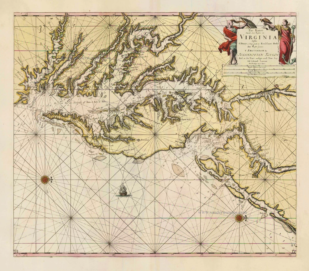
Pas Kaart van de Zee Kusten van Virginia tusschen C. Henry en t Hooge Land van Renselaars Hoek. 1702
Virginia by Johannes van Keulen
[Item number: 1332]
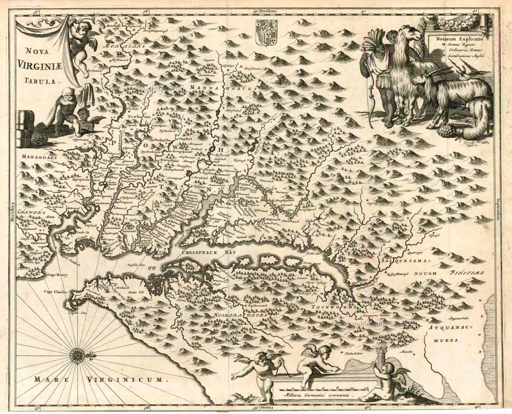
Nova Virginiae Tabula. 1671
Virginia, by A. Montanus.
[Item number: 25613]
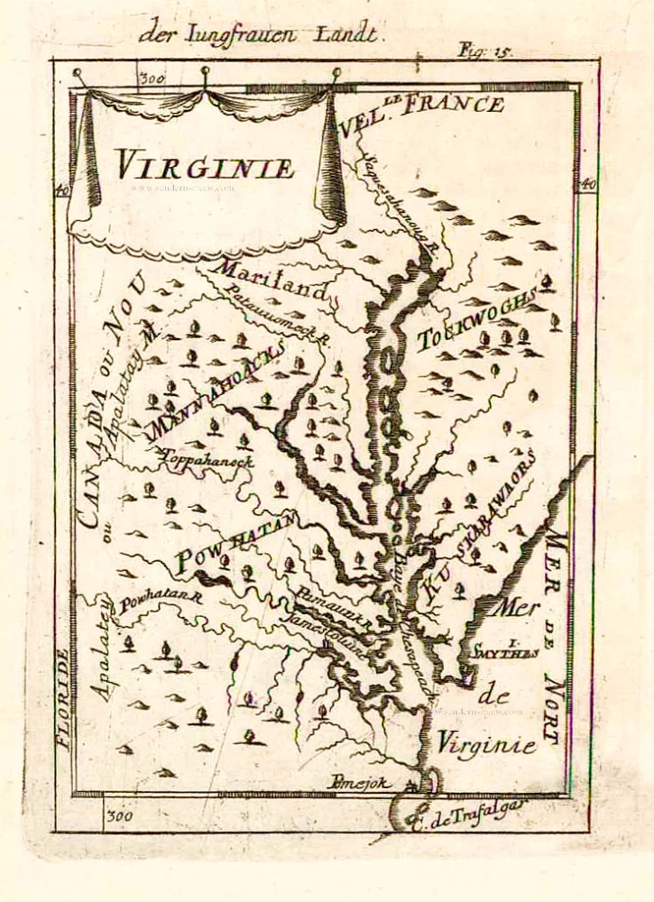
Virginie. 1685
Virginia and Maryland, by A.M. Mallet.
[Item number: 26602]
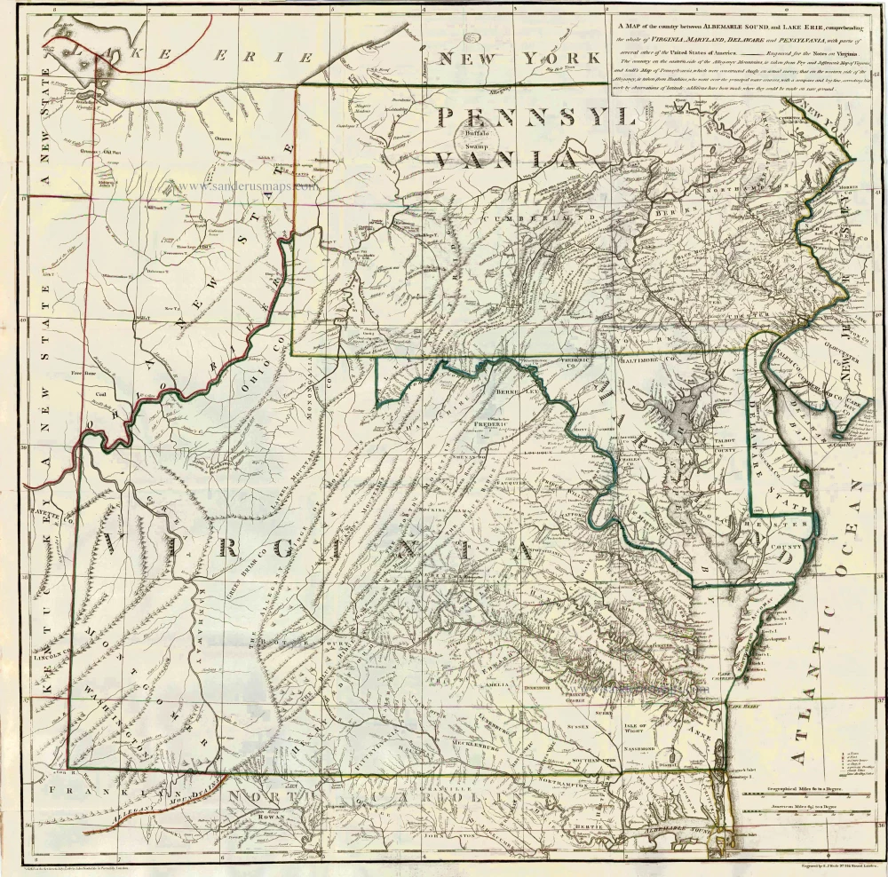
A Map of the country between Albemarle Sound, and Lake Erie, comprehending the whole of Virginia, Maryland, Delaware and Pensylvania, with parts of several other of the United States of America. 1787
Virginia by Thomas Jefferson
[Item number: 27301]