
Virginia by Thomas Jefferson 1787

While serving as the American minister in Paris, Thomas Jefferson prepared in 1786 a detailed draft of a map of Virginia and its neighbouring states to accompany his Notes on the State of Virginia. Jefferson writes about this map: "The country on the eastern side of the Allegany Mountains, is taken from Fry and Jefferson's Map of Virginia and Scull's Map of Pennsylvania ... that on the western side of the Allegany, is taken from Hutchins ... additions have been made, where they could be made on sure ground." This is the only printed map attributed to Thomas Jefferson.
A Map of the country between Albemarle Sound, and Lake Erie, comprehending the whole of Virginia, Maryland, Delaware and Pensylvania, with parts of several other of the United States of America.
Item Number: 27301 Authenticity Guarantee
Category: Antique maps > America > North America
Old, antique map of Virginia by Thomas Jefferson.
Title: A Map of the country between Albemarle Sound, and Lake Erie, comprehending the whole of Virginia, Maryland, Delaware and Pensylvania, with parts of several other of the United States of America.
Date of the first edition: 1787.
Date of this map: 1787.
Size (not including margins): 590 x 590mm (23.23 x 23.23 inches).
Verso: Blank.
Condition: Original coloured in outline, folded as issued, upper and right margins trimmed to neatline.
Condition Rating: A+.
From: Thomas Jefferson, Observations sur la Virginie. Paris, Barrois, 1786 (i.e., 1787).
While serving as the American minister in Paris, Thomas Jefferson prepared in 1786 a detailed draft of a map of Virginia and its neighbouring states to accompany his Notes on the State of Virginia. Jefferson writes about this map: "The country on the eastern side of the Allegany Mountains, is taken from Fry and Jefferson's Map of Virginia and Scull's Map of Pennsylvania ... that on the western side of the Allegany, is taken from Hutchins ... additions have been made, where they could be made on sure ground." This is the only printed map attributed to Thomas Jefferson.
Related items

Pas Kaart van de Zee Kusten van Virginia tusschen C. Henry en t Hooge Land van Renselaars Hoek. 1702
Virginia by Johannes van Keulen
[Item number: 1332]

Nova Virginiae Tabula. 1671
Virginia, by A. Montanus.
[Item number: 25613]

Floride. 1685
Florida, Virginia and Louisiana, by A.M. Mallet.
[Item number: 26599]
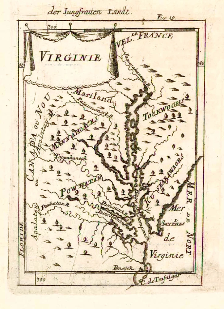
Virginie. 1685
Virginia and Maryland, by A.M. Mallet.
[Item number: 26602]

Nova Virginiae Tabula. 1666
Virginia by Henricus Hondius.
[Item number: 29956]

Luxury colouring
Virginiae partis australis et Floridae partis orientalis, interjacentiumq; regionum Nova Descriptio. 1666
Carolinas and Georgia by Johannes Janssonius
[Item number: 30020]

Virginiae Partis Australis, Et Floridae Partis Orientalis, interjacentiumq regionum Nova Descriptio. 1641
Carolinas and Georgia by Johannes Janssonius.
[Item number: 30319]

D' Engelze Volkplanting in Virginie door Iohan Smith Bezogt en Verder Uytgeset 1707
Virginia, by Pieter Van der Aa.
[Item number: 32400]