
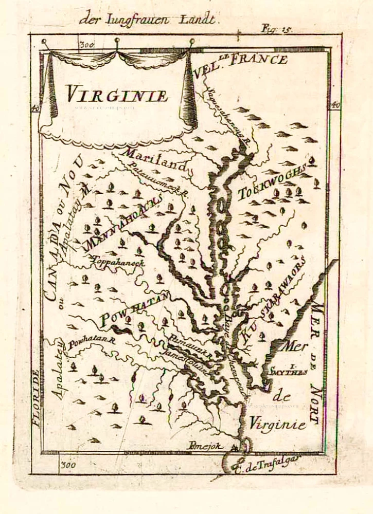
Virginia and Maryland, by A.M. Mallet. 1685
Allain Manesson Mallet (1630-1706)
Allain Manesson Mallet was born in 1630, the son of Philippe Mallet. His father was an ingénieur ordinaire to Louis XIV and a professor of mathematics around 1645. Allain, at first, carried muskets to the regiment of guards of Louis XIV and then became an engineer like his father. Later, becoming a sergeant-major of artillery, he travelled extensively to Spain and Portugal, supervising the fortifications there. On his return to France, he was named master of mathematics. In 1671, he published the Travaux de Mars, a book on military fortifications. He followed in 1683 with the work concerned here, the Description de l'Univers, a five-volume geographical text covering all subjects. It was heavily illustrated with nearly 700 prints and maps. (Burden)
Virginie.
Item Number: 26602 Authenticity Guarantee
Category: Antique maps > America > North America
Old, antique map of Virginia & Maryland, by A.M. Mallet.
Date of the first edition: 1683
Date of this map: 1685
Copper engraving, printed on paper.
Size (not including margins): 16 x 11.5cm (6.2 x 4.5 inches)
Verso: Blank
Condition: Excellent.
Condition Rating: A+
References: Burden, #613.
From: Beschreibung des ganzen Welt-Kreises. Frankfurt, 1685.
Allain Manesson Mallet (1630-1706)
Allain Manesson Mallet was born in 1630, the son of Philippe Mallet. His father was an ingénieur ordinaire to Louis XIV and a professor of mathematics around 1645. Allain, at first, carried muskets to the regiment of guards of Louis XIV and then became an engineer like his father. Later, becoming a sergeant-major of artillery, he travelled extensively to Spain and Portugal, supervising the fortifications there. On his return to France, he was named master of mathematics. In 1671, he published the Travaux de Mars, a book on military fortifications. He followed in 1683 with the work concerned here, the Description de l'Univers, a five-volume geographical text covering all subjects. It was heavily illustrated with nearly 700 prints and maps. (Burden)
Related items

Pas Kaart van de Zee Kusten van Virginia tusschen C. Henry en t Hooge Land van Renselaars Hoek. 1702
Virginia by Johannes van Keulen
[Item number: 1332]

Nova Virginiae Tabula. 1671
Virginia, by A. Montanus.
[Item number: 25613]

Partie Méridionale de la Louisiane, avec la Floride, la Caroline et la Virginie. 1776-79
The United States (Southeast), by Francesco Santini.
[Item number: 26983]

Nova Virginiae Tabula. 1666
Virginia by Henricus Hondius.
[Item number: 29956]

Luxury colouring
Virginiae partis australis et Floridae partis orientalis, interjacentiumq; regionum Nova Descriptio. 1666
Carolinas and Georgia by Johannes Janssonius
[Item number: 30020]

Virginiae Partis Australis, Et Floridae Partis Orientalis, interjacentiumq regionum Nova Descriptio. 1641
Carolinas and Georgia by Johannes Janssonius.
[Item number: 30319]

D' Engelze Volkplanting in Virginie door Iohan Smith Bezogt en Verder Uytgeset 1707
Virginia, by Pieter Van der Aa.
[Item number: 32400]