
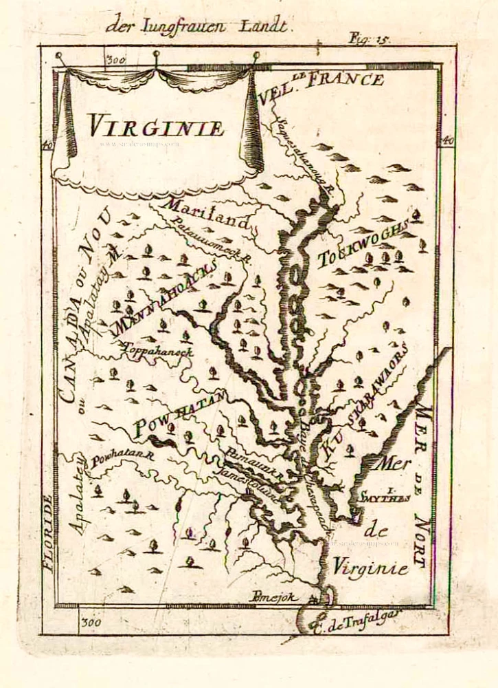
Virginia, by Pieter Van der Aa. 1707

Pieter van der Aa (Leiden, 1659-1733)
Pieter van der Aa was already in 1682 owner of a bookshop and auction house. During his life, he has published an enormous amount of printed material.
After 1700, van der Aa increasingly specialised in books on geography and travel.
He published composite atlases, a series of geographical descriptions of European countries, and some very spectacular works. Between 1706 and 1708 he published the Naauweurige versameling der gedenkwaardigste zee- en land-reysen, in 28 volumes.
Many of Van der Aa’s publications are richly illustrated with maps and plates. He took over many copperplates and prints from other publishers such as Carel Allard and Frederik De Wit. The composite atlases that appeared from his workshop contain a curious mixture of his own material, copies of maps from other publishers, and reprints made from old copper plates, now with his own imprint.
The Galérie agréable du monde, was completed in 1729, and comprised 66 parts, bound in 27 volumes. Van der Aa presented it as a good investment; after publication, the antiquarian value of the work would double, the more so since it was printed in a limited edition of only one hundred copies.
D' Engelze Volkplanting in Virginie door Iohan Smith Bezogt en Verder Uytgeset
Item Number: 32400 Authenticity Guarantee
Category: Antique maps > America > North America
Virginia, by Pieter Van der Aa. Very rare
Title: D' Engelze Volkplanting in Virginie door Iohan Smith Bezogt en Verder Uytgeset
Uytgevoerd te Leyden door Pieter Vander Aa met Privilegie. - 2de Iohan Smith.
Cartographer: John Smith.
Date of the first edition: 1707.
Date of this map: 1707.
Copper engraving, printed on paper.
Image size: 160 x 230mm (6¼ x 9 inches).
Sheet size: 175 x 280mm (7 x 11 inches).
Verso: Blank.
Condition: Excellent.
Condition Rating: A+.
From: Naaukeurige Versameling der gedenk-waardigste Zee- en landreysen na Oost en West-Indien. Leiden, Pieter Van der Aa, 1707.
Pieter van der Aa (Leiden, 1659-1733)
Pieter van der Aa was already in 1682 owner of a bookshop and auction house. During his life, he has published an enormous amount of printed material.
After 1700, van der Aa increasingly specialised in books on geography and travel.
He published composite atlases, a series of geographical descriptions of European countries, and some very spectacular works. Between 1706 and 1708 he published the Naauweurige versameling der gedenkwaardigste zee- en land-reysen, in 28 volumes.
Many of Van der Aa’s publications are richly illustrated with maps and plates. He took over many copperplates and prints from other publishers such as Carel Allard and Frederik De Wit. The composite atlases that appeared from his workshop contain a curious mixture of his own material, copies of maps from other publishers, and reprints made from old copper plates, now with his own imprint.
The Galérie agréable du monde, was completed in 1729, and comprised 66 parts, bound in 27 volumes. Van der Aa presented it as a good investment; after publication, the antiquarian value of the work would double, the more so since it was printed in a limited edition of only one hundred copies.
Related items

Pas Kaart van de Zee Kusten van Virginia tusschen C. Henry en t Hooge Land van Renselaars Hoek. 1702
Virginia by Johannes van Keulen
[Item number: 1332]

Nova Virginiae Tabula. 1671
Virginia, by A. Montanus.
[Item number: 25613]

Virginiae Partis Australis, Et Floridae Partis Orientalis, interjacentiumq regionum Nova Descriptio. 1642-43
Carolinas by Willem Blaeu.
[Item number: 25800]

Floride. 1685
Florida, Virginia and Louisiana, by A.M. Mallet.
[Item number: 26599]
Virginie. 1685
Virginia and Maryland, by A.M. Mallet.
[Item number: 26602]

Very important map with a view of New York
Novi Belgii novaeque Angliae nec non partis Virginiae Tabula. 1656-77
New England by Nicolaes Visscher I.
[Item number: 28549]

Nova Virginiae Tabula. 1666
Virginia by Henricus Hondius.
[Item number: 29956]

Virginiae Partis Australis, Et Floridae Partis Orientalis, interjacentiumq regionum Nova Descriptio. 1641
Carolinas and Georgia by Johannes Janssonius.
[Item number: 30319]