
North America, by Zacharias Châtelain. 1713

The Châtelain Family
Zacharias Châtelain (1684-1743) was a bookseller and publisher of Amsterdam. He was succeeded by his sons Zacharias jr and Henry Abraham. The Châtelain family was best known for the historical atlas Atlas Historique, ou nouvelle introduction à l’histoire…, a major work of its time. It was an encyclopaedia in seven volumes, including geography as one of its main subjects. The atlas was published in Amsterdam in seven volumes in various editions with different imprints from 1705 to 1739. An anonym person (Mr. C***) compiled the work with compositions of text, maps, plates and chronological and genealogical tables by Gueudeville, except volume 7, where H.P. Limiers took over this task. The maps were made mainly after the work of Guillaume de l'Isle.
The 1705 edition was published with the imprint “L’Honoré & Châtelain”. Later editions had the imprint: “les Frères Châtelain Libraires” or “L’Honoré & Châtelain Libraires”.
Nouvelle carte de l'Amérique Septentrionale dressée sur les plus nouvelles observations de Messieurs de l'Académie des Sciences et des meilleurs Géographes avec des tables très Instructives et Curieuses de la Division de tous les Etats et les différents souverains qui en sont possesseur.
Item Number: 29445 Authenticity Guarantee
Category: Antique maps > America > North America
Old, antique map of North America, by Zacharias Châtelain.
Title: Nouvelle carte de l'Amérique Septentrionale dressée sur les plus nouvelles observations de Messieurs de l'Académie des Sciences et des meilleurs Géographes avec des tables très Instructives et Curieuses de la Division de tous les Etats et les différents souverains qui en sont possesseur.
N° F.
Date of the first edition: 1713.
Date of this map: 1713.
Copper engraving, printed on paper.
Map size: 470 x 590mm (18.5 x 23.23 inches).
Sheet size: 535 x 635mm (21.06 x 25 inches).
Verso: Blank.
Condition: Folds as issued, excellent.
Condition Rating: A+.
From: Châtelain Z. Atlas Historique, ou Nouvelle Introduction A l'Histoire, à la Chronologie & à la Geographie Ancienne & Moderne; ... Tome Premier. Conténant la Gréce, l'Histoire Romaine, Rome Moderne, Naples, la France, l'Espagne, & les Provinces Unies.A Amsterdam, Chez L'Honoré & Châtelain, M.DCC.XIII. (1713). (Koeman II, p. 35, Cha2)
The Châtelain Family
Zacharias Châtelain (1684-1743) was a bookseller and publisher of Amsterdam. He was succeeded by his sons Zacharias jr and Henry Abraham. The Châtelain family was best known for the historical atlas Atlas Historique, ou nouvelle introduction à l’histoire…, a major work of its time. It was an encyclopaedia in seven volumes, including geography as one of its main subjects. The atlas was published in Amsterdam in seven volumes in various editions with different imprints from 1705 to 1739. An anonym person (Mr. C***) compiled the work with compositions of text, maps, plates and chronological and genealogical tables by Gueudeville, except volume 7, where H.P. Limiers took over this task. The maps were made mainly after the work of Guillaume de l'Isle.
The 1705 edition was published with the imprint “L’Honoré & Châtelain”. Later editions had the imprint: “les Frères Châtelain Libraires” or “L’Honoré & Châtelain Libraires”.
Related items

L'Amerique Septentrionale. 1708
North America by G. de L'Isle, published by Pierre Mortier.
[Item number: 29510]

Landmark map of North Amerika
Amerique Septentrionale. 1652
Nicolas Sanson's landmark map of North America, scarce second state.
[Item number: 29597]

Big and spectacular map, heightened in gold.
Amerique Septentrionale, divisée en ses principales parties, ou sont distingués les uns des autres Les Estats suivant qu'ils appartiennet Presentemet aux Francois, Castillans, Anglois, Suedois, Danois, Hollandois. 1692
North America by N. Sanson, so-called published by Hubert Jaillot. (Pirated edition by Pierre Mortier).
[Item number: 29895]

California as an island.
L'Amerique Septentrionale qui fait partie des Indes Occidentales. 1719
North America by Chiquet Jacques.
[Item number: 30085]

California as an island.
Americque Septentrionale. 1715
North America by Nicolas Sanson, published by Nicolas Chemereau.
[Item number: 30086]

From 'Diderot & d'Alembert'
Carte de la Californie Suivant I. La Carte manuscrite de l'Amérique de Mathieu Néron Pecci olen dresses à Florence en 1604. II. Sanson 1656. III. De l'Isle Amérique Sept. 1700. IV. le Pere Kino Jesuite en 1705. V. la Société des Jésuites en 1767. 1777
California by Robert de Vaugondy.
[Item number: 30091]

Carte de la Partie de l'Amérique Septentrionale, comprenant les Possessions Espagnoles. 1788
North America by Louis Brion de la Tour.
[Item number: 30144]

Carte d'Assemblage de l'Amérique Septen-le 1827
North America by Philippe Vandermaelen.
[Item number: 31099]

One of Antwerp's most beautiful maps
Marchionatus Sacri Romani Imperii. c. 1760
Antwerp, by Nicolaes Visscher I, published by Petrus Schenk Jr.
[Item number: 31137]

Amerique Septentrionale, Divisee en ses Principales Parties, ou sont Distingues les Uns des Autres les Estats Suivant qu'ils Appartiennent Presentemet aux Francois, Castillans, Anglois, Suedois, Danois, Hollandois. 1692
North America by N. Sanson, so-called published by Hubert Jaillot. (Pirated edition by Pierre Mortier).
[Item number: 31142]
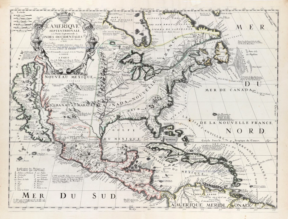
Rare first edition of the important Coronelli-Nolin map of North America
L'Amerique Septentrionale, ou la Partie Septentrionale des Indes Occidentales. 1689
North and Central America by Vincenzo Coronelli, published by J.B. Nolin.
[Item number: 31338]

L' America Settentrionale. 1677
North America by Giovanni De Rossi, after Nicolas Sanson.
[Item number: 32889]