
North America by G. de L'Isle, published by Pierre Mortier. 1708


This map is a derivative of de L'Isle's map of 1700 (See Burden, 761, p.485). The title cartouche is transferred to the left-hand top corner, and the scale of miles is moved to the top right corner within a new design of a draped curtain. The Avertissement is discarded. An additional title in Latin appears above the map.
Guillaume Delisle (Paris, 1675 – 1726)
Guillaume Delisle (de L’Isle), one of the key figures in the development of French cartography, is the son of Claude Delisle, a cartographer, and the half-brother of astronomers Joseph-Nicolas Delisle and Louis de l'Isle de la Croyère.
While his father has to be given credit for educating Guillaume, the boy showed early signs of being an exceptional talent. He soon contributed to the family workshop by drawing maps for his father's historical works. To perfect his skills, Guillaume Delisle became the student of the astronomer Jean-Dominique Cassini. Early on, he produced high-quality maps, the first being his Carte de la Nouvelle-France et des Pays Voisins in 1696. Delisle's first atlas appeared around 1700, and in 1702 he became a member of the French Académie Royale des Sciences. He taught geography to the young Louis XV, and in 1718 he received the title of Premier Géographe du Roi. On a commission from Peter the Great, he produced a map of the Caspian Sea, a region barely known. Many of the place names he gave are still in use. His Carte de la Louisiane et du cours du Mississippi (1718) is the first detailed map of this region.
A six-year-long plagiarism trial pits Delisle against Jean-Baptiste Nolin, cartographer. It is Nolin, the real plagiarist, who loses.
Delisle has remained famous for his astronomical-based corrections and the completeness of its topography. The high scientific quality of the work produced by the Delisle family contrasted with the workshop of Sanson. While Sanson knowingly published outdated facts and mistakes, Delisle constantly updated his maps to reflect widening knowledge of the world.
Covens & Mortier. A Map Publishing House in Amsterdam. 1721-1866.
During almost two centuries, the largest and most important Dutch publishing house in commercial cartography was the Amsterdam firm of Covens & Mortier. Concerning quantity, it was possibly even the biggest contemporary map-trading house worldwide. They distributed innumerable maps, atlases, globes, and books.
Pieter (Pierre) Mortier (Leiden, 1661 – Amsterdam, 1711)
Nothing is known about the youth of Pieter Mortier. He studied in Paris from 1681 to approximately 1685. There he must have come into contact with French 'libraires' and learned the bookselling trade. Beginning 1685 he returned to Amsterdam where he opened a small bookshop. In the same year, he became a member of the Book, Art Sellers' and Printers' guild.
Pieter sold books in Dutch and foreign languages, but he also published books on his own, usually in the French language. His business flourished such that in 1688 he was already forced to rent another house on the Vijgendam.
Pieter Mortier's first privilege for maps was granted by the States of Holland and West Friesland on September 15 1690. It refers to the maps of Sanson that he 'is printing and correcting with great pains and care'.
Pieter began the large scale publication of maps and atlases. By the beginning of the 18th century, Pieter had become so wealthy that he could purchase three houses in Amsterdam: on the Beurssluis, on the Vijgendam, and the Heremietensteeg. He rebuilt the house on the Vijgendam into a large prestigious house that would serve for over a century as a shop, business, and residential structure for Covens & Mortier's publishing house.
He died on February 13, 1711, after a brief illness. The company continued to exist under Pieter's widow's management, Amelia' s-Gravesande.
After she died in 1719, her son Cornelis, took over the management for a few years.
On November 20, 1721, a company was founded by Cornelis Mortier and Johannes Covens I. The latter was married the same year with Cornelis's sister. From that year on, the name of :
Covens & Mortier.
Their firm would see a massive expansion in the next 140 years. In 1732 the heirs sold the property to their brother Cornelis and his partner Covens. Their main competitors were Reinier & Josua Ottens and Gerard Valck & Petrus Schenck. After the death of Johannes Covens I (1774), his son Johannes Covens II (1722-1794) entered the business. From 1778, Johannes added a new company name :
J. Covens & Son.
Johannes Covens II was succeeded by his son Cornelis Covens (1764-1825), who, in turn, brought Peter Mortier IV, the great-grandson of Petrus Mortier I, into the business. The name was from 1794 to 1866:
Mortier, Covens & Son.
The last Covens in the series was Cornelis Johannes Covens (1806-1880).
Covens & Mortier had a large stock of atlases and maps, including those of: Delisle, Jaillot, Johannes Janssonius, Sanson, Claes Jansz. Visscher, Nicolaas Visscher, and Frederik de Wit. For decades, an impressive number of atlases came from the press.
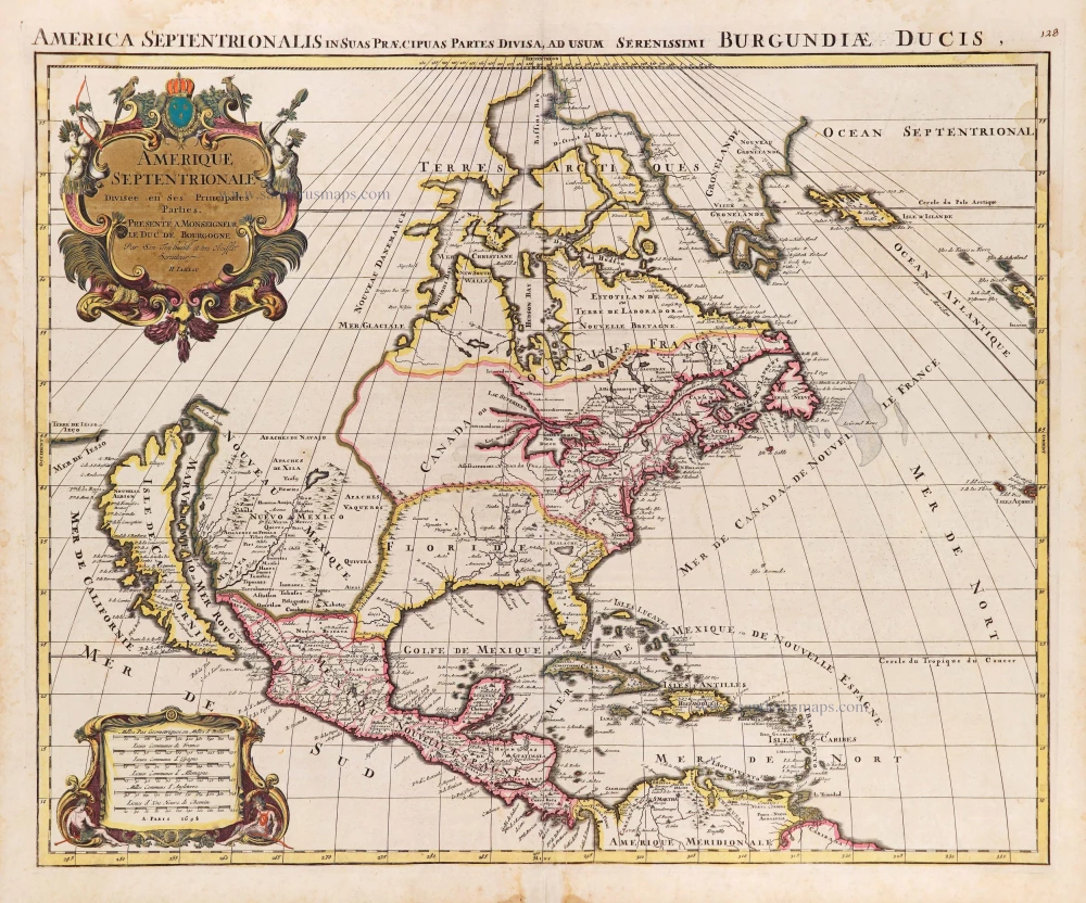
L'Amerique Septentrionale.
Item Number: 29510 Authenticity Guarantee
Category: Antique maps > America > North America
Old antique map of North America by G. de L'Isle, published by Pierre Mortier.
Title: L'Amerique Septentrionale.
Dressee sur les Observations de Mrs. de l'Academie Royale des Sciences & quelques autres, & sur les Memoires les plus recens.
Par G. De L'Isle.
A Amsterdam Chez Pierre Mortier.
Avec Privilege.
Additional title above the map: America Septentrionalis in suas Praecipuas partes divisa, ad usum Serenissimi Burgundiae Ducis.
Cartographer: Guillaume Delisle.
Date of the first edition: 1700 (Delisle).
Date of this map: c. 1707.
Copper engraving, printed on paper.
Map size: 470 x 570mm (18.5 x 22.44 inches).
Sheet size: 520 x 615mm (20.47 x 24.21 inches).
Verso: Blank.
Condition: Original coloured in outline, excellent.
Condition Rating: A+.
From: Atlas Nouveau de diverse cartes choisies des Meilleurs Geographes comme Sanson, G. De L'Isle &c.. A Amsterdam, Chez Pierre Mortier, MDCCVIII.
This map is a derivative of de L'Isle's map of 1700 (See Burden, 761, p.485). The title cartouche is transferred to the left-hand top corner, and the scale of miles is moved to the top right corner within a new design of a draped curtain. The Avertissement is discarded. An additional title in Latin appears above the map.
Guillaume Delisle (Paris, 1675 – 1726)
Guillaume Delisle (de L’Isle), one of the key figures in the development of French cartography, is the son of Claude Delisle, a cartographer, and the half-brother of astronomers Joseph-Nicolas Delisle and Louis de l'Isle de la Croyère.
While his father has to be given credit for educating Guillaume, the boy showed early signs of being an exceptional talent. He soon contributed to the family workshop by drawing maps for his father's historical works. To perfect his skills, Guillaume Delisle became the student of the astronomer Jean-Dominique Cassini. Early on, he produced high-quality maps, the first being his Carte de la Nouvelle-France et des Pays Voisins in 1696. Delisle's first atlas appeared around 1700, and in 1702 he became a member of the French Académie Royale des Sciences. He taught geography to the young Louis XV, and in 1718 he received the title of Premier Géographe du Roi. On a commission from Peter the Great, he produced a map of the Caspian Sea, a region barely known. Many of the place names he gave are still in use. His Carte de la Louisiane et du cours du Mississippi (1718) is the first detailed map of this region.
A six-year-long plagiarism trial pits Delisle against Jean-Baptiste Nolin, cartographer. It is Nolin, the real plagiarist, who loses.
Delisle has remained famous for his astronomical-based corrections and the completeness of its topography. The high scientific quality of the work produced by the Delisle family contrasted with the workshop of Sanson. While Sanson knowingly published outdated facts and mistakes, Delisle constantly updated his maps to reflect widening knowledge of the world.
Covens & Mortier. A Map Publishing House in Amsterdam. 1721-1866.
During almost two centuries, the largest and most important Dutch publishing house in commercial cartography was the Amsterdam firm of Covens & Mortier. Concerning quantity, it was possibly even the biggest contemporary map-trading house worldwide. They distributed innumerable maps, atlases, globes, and books.
Pieter (Pierre) Mortier (Leiden, 1661 – Amsterdam, 1711)
Nothing is known about the youth of Pieter Mortier. He studied in Paris from 1681 to approximately 1685. There he must have come into contact with French 'libraires' and learned the bookselling trade. Beginning 1685 he returned to Amsterdam where he opened a small bookshop. In the same year, he became a member of the Book, Art Sellers' and Printers' guild.
Pieter sold books in Dutch and foreign languages, but he also published books on his own, usually in the French language. His business flourished such that in 1688 he was already forced to rent another house on the Vijgendam.
Pieter Mortier's first privilege for maps was granted by the States of Holland and West Friesland on September 15 1690. It refers to the maps of Sanson that he 'is printing and correcting with great pains and care'.
Pieter began the large scale publication of maps and atlases. By the beginning of the 18th century, Pieter had become so wealthy that he could purchase three houses in Amsterdam: on the Beurssluis, on the Vijgendam, and the Heremietensteeg. He rebuilt the house on the Vijgendam into a large prestigious house that would serve for over a century as a shop, business, and residential structure for Covens & Mortier's publishing house.
He died on February 13, 1711, after a brief illness. The company continued to exist under Pieter's widow's management, Amelia' s-Gravesande.
After she died in 1719, her son Cornelis, took over the management for a few years.
On November 20, 1721, a company was founded by Cornelis Mortier and Johannes Covens I. The latter was married the same year with Cornelis's sister. From that year on, the name of :
Covens & Mortier.
Their firm would see a massive expansion in the next 140 years. In 1732 the heirs sold the property to their brother Cornelis and his partner Covens. Their main competitors were Reinier & Josua Ottens and Gerard Valck & Petrus Schenck. After the death of Johannes Covens I (1774), his son Johannes Covens II (1722-1794) entered the business. From 1778, Johannes added a new company name :
J. Covens & Son.
Johannes Covens II was succeeded by his son Cornelis Covens (1764-1825), who, in turn, brought Peter Mortier IV, the great-grandson of Petrus Mortier I, into the business. The name was from 1794 to 1866:
Mortier, Covens & Son.
The last Covens in the series was Cornelis Johannes Covens (1806-1880).
Covens & Mortier had a large stock of atlases and maps, including those of: Delisle, Jaillot, Johannes Janssonius, Sanson, Claes Jansz. Visscher, Nicolaas Visscher, and Frederik de Wit. For decades, an impressive number of atlases came from the press.
Related items

Limes Occidentis Quivira et Anian. 1607
West coast by Wytfliet, Cornelis van
[Item number: 26513]

Canada ou Nouvelle France. 1685
North America (Northeast), by A.M. Mallet.
[Item number: 26601]

Amerique Septentrionale. 1685
North America, by A.M. Mallet.
[Item number: 26643]

Karte von Nord-America, zur Geschichte von Neu-Frankreich. 1747-74
North America, by Jacques Nicolas Bellin.
[Item number: 26799]
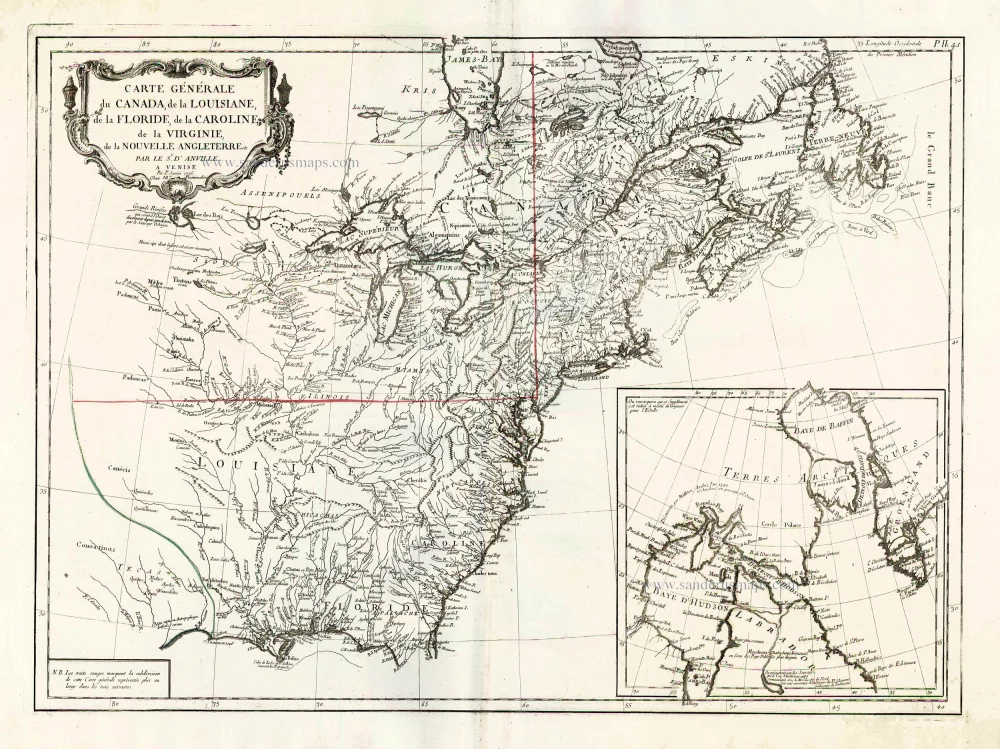
Carte Générale du Canada, de la Louisiane, de la Floride, de la Caroline, de la Virginie, de la Nouvelle Angleterre etc. 1776-79
North America (East), by Paolo Santini.
[Item number: 26980]

Earliest obtainable map of North America
Mondo Nuovo - Descrittione del l'Isola et Terra di Sancta Croce, overo Mondo Nuovo. 1576
Tomaso Porcacchi., North America
[Item number: 27651]

Early 'Texas' map
Nueva Hispania Tabula Nova. 1574
North America, by Girolamo Ruscelli.
[Item number: 27755]

Amerique Septentrionale. 1748
North America by Robert de Vaugondy.
[Item number: 28157]
Amerique Septentrionale, Divisee en ses Principales Parties. 1694
North America, by Nicolas Sanson, published by Pierre Mortier after A.H. Jaillot.
[Item number: 29125]

Carte de la Nouvelle France, ou se Voit le Cours des Grandes Rivieres de S. Laurens & de Mississipi Aujourd'hui S. Louis, Aux environs des quelles se trouvent les Etats, Païs, Nations, Peuples &c. de la Floride, de la Louisiane, de la Virginie, de la Marie-Lande, de la Pensilvanie, du Nouveau Jersay, de la Nouvelle Yorck, de la Nouv. Angleterre, de l'Acadie, du Canada, des Esquimaux, des Hurons, des Iroquois, des Ilinois &c. Et de la Grande Ile de Terre Neuve:. 1719
Eastern North America (U.S.), by Zacharias Châtelain.
[Item number: 29365]

Nouvelle carte de l'Amérique Septentrionale dressée sur les plus nouvelles observations de Messieurs de l'Académie des Sciences et des meilleurs Géographes avec des tables très Instructives et Curieuses de la Division de tous les Etats et les différents souverains qui en sont possesseur. 1713
North America, by Zacharias Châtelain.
[Item number: 29445]

Landmark map of North Amerika
Amerique Septentrionale. 1652
Nicolas Sanson's landmark map of North America, scarce second state.
[Item number: 29597]

Big and spectacular map, heightened in gold.
Amerique Septentrionale, divisée en ses principales parties, ou sont distingués les uns des autres Les Estats suivant qu'ils appartiennet Presentemet aux Francois, Castillans, Anglois, Suedois, Danois, Hollandois. 1692
North America by N. Sanson, so-called published by Hubert Jaillot. (Pirated edition by Pierre Mortier).
[Item number: 29895]

California as an island.
L'Amerique Septentrionale qui fait partie des Indes Occidentales. 1719
North America by Chiquet Jacques.
[Item number: 30085]

California as an island.
Americque Septentrionale. 1715
North America by Nicolas Sanson, published by Nicolas Chemereau.
[Item number: 30086]

From 'Diderot & d'Alembert'
Carte de la Californie Suivant I. La Carte manuscrite de l'Amérique de Mathieu Néron Pecci olen dresses à Florence en 1604. II. Sanson 1656. III. De l'Isle Amérique Sept. 1700. IV. le Pere Kino Jesuite en 1705. V. la Société des Jésuites en 1767. 1777
California by Robert de Vaugondy.
[Item number: 30091]

Carte de la Partie de l'Amérique Septentrionale, comprenant les Possessions Espagnoles. 1788
North America by Louis Brion de la Tour.
[Item number: 30144]

Carte d'Assemblage de l'Amérique Septen-le 1827
North America by Philippe Vandermaelen.
[Item number: 31099]

Amerique Septentrionale, Divisee en ses Principales Parties, ou sont Distingues les Uns des Autres les Estats Suivant qu'ils Appartiennent Presentemet aux Francois, Castillans, Anglois, Suedois, Danois, Hollandois. 1692
North America by N. Sanson, so-called published by Hubert Jaillot. (Pirated edition by Pierre Mortier).
[Item number: 31142]
Rare first edition of the important Coronelli-Nolin map of North America
L'Amerique Septentrionale, ou la Partie Septentrionale des Indes Occidentales. 1689
North and Central America by Vincenzo Coronelli, published by J.B. Nolin.
[Item number: 31338]

L' America Settentrionale. 1677
North America by Giovanni De Rossi, after Nicolas Sanson.
[Item number: 32889]