
West coast by Wytfliet, Cornelis van 1607

In 1597 Cornelis van Wytfliet published his Augmentum to Ptolemy's Geography. This is true as much as it covers all the Americas, a part of the world unknown to the latter; however, no other connection exists. Dedicated to Philip III of Spain, it is a history of the New World, recording its discovery, natural history etc. For the book, Wytfliet had engraved nineteen maps, by whom we do not know, one of the world and eighteen regional maps of the Americas. This book can be indeed called the first atlas of America. It was an immediate success and ran to several editions.
This is one of two maps that are of the west coast of North America. It covers the entire coastal portions of the present-day United States and Canada.
Cornelius Wytfliet (? – 1597)
Cornelius Wytfliet was a geographer from Leuven. After graduating with a Licentiate in Laws from the University of Leuven, Wytfliet moved to Brussels and became secretary to the Council of Brabant.
In 1597, he published the first atlas of America: the Descriptionis Ptolemaicae Augmentum (Augmentation to Ptolemy’s description). He named his work an augmentation of Ptolemy’s Geography because it covers the Americas, a part of the world unknown to Ptolemy. However, there is no other connection between the works of Ptolemy and Van Wytfliet. Dedicated to Philip III of Spain, it is a history of the New World to date, recording its discovery, natural history, etc. It provides a history of exploration and the voyages of Christopher Columbus (1492-1502), John Cabot (1497-98), Sebastian Cabot (1526-28), Francisco Pizarro (1527-35), Giovanni de Verazzano (1524), Jacques Cartier (1540-42), and Martin Frobisher (1576-78). Most of Van Wytfliet’s maps are the first or among the earliest of specific regions of North and South America.
For the book, Wytfliet had engraved nineteen maps, one of the world and eighteen regional maps of the Americas. The book was an immediate success and ran to several editions.
Two editions of the Descriptionis Ptolemaicae were published at Leuven in 1597 and 1598, and in 1603, the first Douai edition appeared, with later editions with French text. The last edition was published in Arnhem in 1615.
Limes Occidentis Quivira et Anian.
Item Number: 26513 Authenticity Guarantee
Category: Antique maps > America > North America
Old, antique map of NW North America, by C. van Wytfliet.
Date of the first edition: 1597
Date of this map: 1607
Copper engraving, printed on paper.
Size (not including margins): 23.5 x 29cm (9.2 x 11.3 inches)
Verso: Blank
Condition: A few stains.
Condition Rating: A
References: Van der Krogt 3, 9190:371.2; Burden, 107, State 2; Wagner, #189.
From: Histoire Universelle des Indes Occidentales. Douai, Françoes Fabri, 1607. (Van der Krogt 3, 371:12)
In 1597 Cornelis van Wytfliet published his Augmentum to Ptolemy's Geography. This is true as much as it covers all the Americas, a part of the world unknown to the latter; however, no other connection exists. Dedicated to Philip III of Spain, it is a history of the New World, recording its discovery, natural history etc. For the book, Wytfliet had engraved nineteen maps, by whom we do not know, one of the world and eighteen regional maps of the Americas. This book can be indeed called the first atlas of America. It was an immediate success and ran to several editions.
This is one of two maps that are of the west coast of North America. It covers the entire coastal portions of the present-day United States and Canada.
Cornelius Wytfliet (? – 1597)
Cornelius Wytfliet was a geographer from Leuven. After graduating with a Licentiate in Laws from the University of Leuven, Wytfliet moved to Brussels and became secretary to the Council of Brabant.
In 1597, he published the first atlas of America: the Descriptionis Ptolemaicae Augmentum (Augmentation to Ptolemy’s description). He named his work an augmentation of Ptolemy’s Geography because it covers the Americas, a part of the world unknown to Ptolemy. However, there is no other connection between the works of Ptolemy and Van Wytfliet. Dedicated to Philip III of Spain, it is a history of the New World to date, recording its discovery, natural history, etc. It provides a history of exploration and the voyages of Christopher Columbus (1492-1502), John Cabot (1497-98), Sebastian Cabot (1526-28), Francisco Pizarro (1527-35), Giovanni de Verazzano (1524), Jacques Cartier (1540-42), and Martin Frobisher (1576-78). Most of Van Wytfliet’s maps are the first or among the earliest of specific regions of North and South America.
For the book, Wytfliet had engraved nineteen maps, one of the world and eighteen regional maps of the Americas. The book was an immediate success and ran to several editions.
Two editions of the Descriptionis Ptolemaicae were published at Leuven in 1597 and 1598, and in 1603, the first Douai edition appeared, with later editions with French text. The last edition was published in Arnhem in 1615.
Related items

Estotilandia et Laboratoris Terra. 1607
Greenland and Northeast Canada, by C. van Wytfliet.
[Item number: 26499]
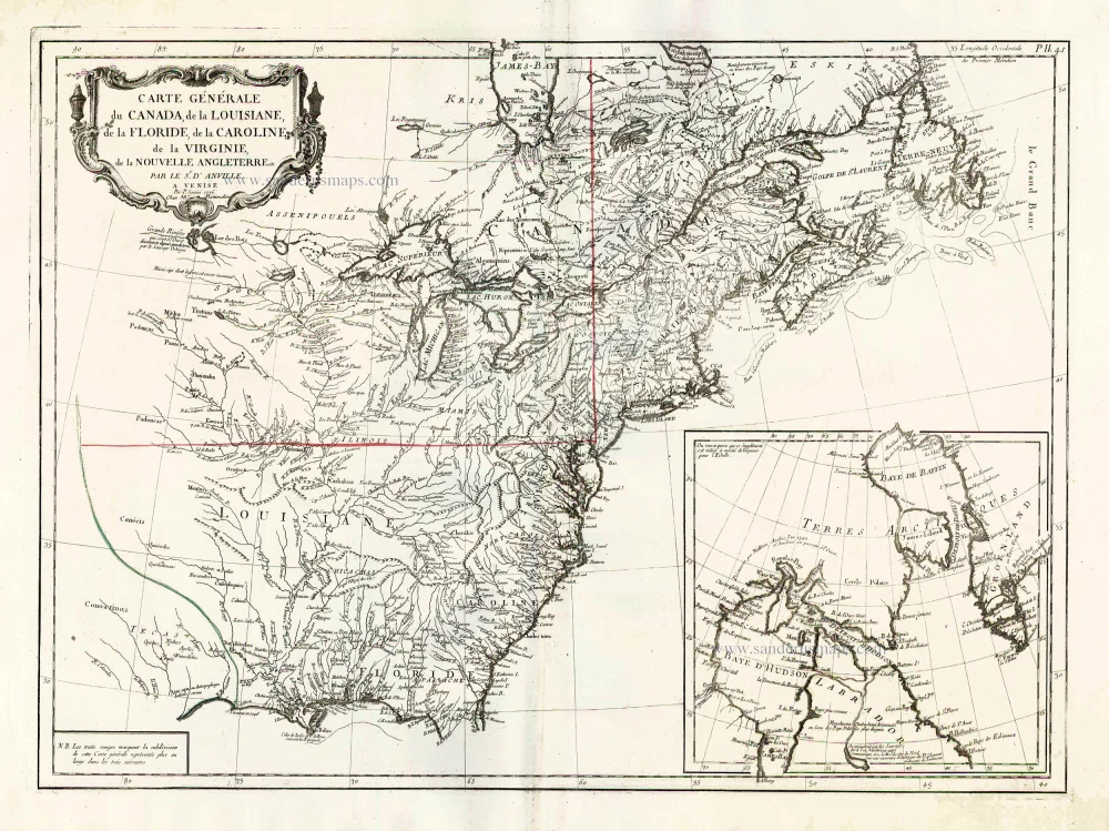
Carte Générale du Canada, de la Louisiane, de la Floride, de la Caroline, de la Virginie, de la Nouvelle Angleterre etc. 1776-79
North America (East), by Paolo Santini.
[Item number: 26980]

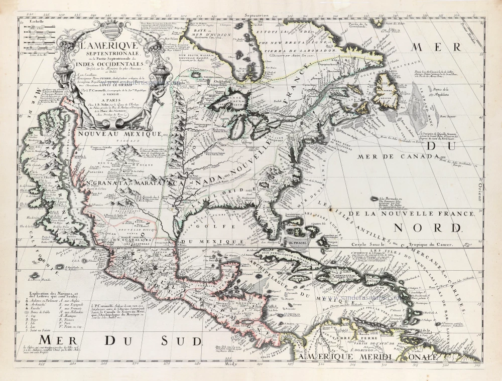
L'Amerique Septentrionale. 1708
North America by G. de L'Isle, published by Pierre Mortier.
[Item number: 29510]

Landmark map of North Amerika
Amerique Septentrionale. 1652
Nicolas Sanson's landmark map of North America, scarce second state.
[Item number: 29597]

Big and spectacular map, heightened in gold.
Amerique Septentrionale, divisée en ses principales parties, ou sont distingués les uns des autres Les Estats suivant qu'ils appartiennet Presentemet aux Francois, Castillans, Anglois, Suedois, Danois, Hollandois. 1692
North America by N. Sanson, so-called published by Hubert Jaillot. (Pirated edition by Pierre Mortier).
[Item number: 29895]

California as an island.
L'Amerique Septentrionale qui fait partie des Indes Occidentales. 1719
North America by Chiquet Jacques.
[Item number: 30085]

California as an island.
Americque Septentrionale. 1715
North America by Nicolas Sanson, published by Nicolas Chemereau.
[Item number: 30086]

From 'Diderot & d'Alembert'
Carte de la Californie Suivant I. La Carte manuscrite de l'Amérique de Mathieu Néron Pecci olen dresses à Florence en 1604. II. Sanson 1656. III. De l'Isle Amérique Sept. 1700. IV. le Pere Kino Jesuite en 1705. V. la Société des Jésuites en 1767. 1777
California by Robert de Vaugondy.
[Item number: 30091]

Carte d'Assemblage de l'Amérique Septen-le 1827
North America by Philippe Vandermaelen.
[Item number: 31099]

Amerique Septentrionale, Divisee en ses Principales Parties, ou sont Distingues les Uns des Autres les Estats Suivant qu'ils Appartiennent Presentemet aux Francois, Castillans, Anglois, Suedois, Danois, Hollandois. 1692
North America by N. Sanson, so-called published by Hubert Jaillot. (Pirated edition by Pierre Mortier).
[Item number: 31142]
Rare first edition of the important Coronelli-Nolin map of North America
L'Amerique Septentrionale, ou la Partie Septentrionale des Indes Occidentales. 1689
North and Central America by Vincenzo Coronelli, published by J.B. Nolin.
[Item number: 31338]

L' America Settentrionale. 1677
North America by Giovanni De Rossi, after Nicolas Sanson.
[Item number: 32889]