
Greenland and Northeast Canada, by C. van Wytfliet. 1607

This second map from Wytfliet's atlas, the first specifically on America, is centred on Davis Strait and shows Greenland and the extreme north-eastern part of Canada. Also depicted is Iceland and the apocryphal island of Frisland. The latter, first appearing on the 1558 map of Nicolo Zeno, was given credence by Gerard Mercator in his world map of 1569 and endured for a considerable period. It is interesting to note the number of towns shown on the island. The map's importance lies in its focus on the area of the English voyages of Frobisher and Davis; they are depicted here in greater detail than before. Clearly derived from the Cornelis Claesz Nova Francia of 1594, Wytfliet interestingly draws upon the inset on it for the area of Labrador, which had offered an alternative representation to the main map. Some information is shown twice on this map as both Frobisher and Davis visited the same shores but were unaware of the fact. Hence FORBISSERI ANGUSTIAE, or Frobisher Bay as we know it, shown on the map below, Greenland is the same as 'L. Lumleys Inlet is shown further west in its true location north of the Hudson Strait. The latter is labelled A furious over fall. Hudson Bay itself remained unknown for a few more years.
Cornelius Wytfliet (? – 1597)
Cornelius Wytfliet was a geographer from Leuven. After graduating with a Licentiate in Laws from the University of Leuven, Wytfliet moved to Brussels and became secretary to the Council of Brabant.
In 1597, he published the first atlas of America: the Descriptionis Ptolemaicae Augmentum (Augmentation to Ptolemy’s description). He named his work an augmentation of Ptolemy’s Geography because it covers the Americas, a part of the world unknown to Ptolemy. However, there is no other connection between the works of Ptolemy and Van Wytfliet. Dedicated to Philip III of Spain, it is a history of the New World to date, recording its discovery, natural history, etc. It provides a history of exploration and the voyages of Christopher Columbus (1492-1502), John Cabot (1497-98), Sebastian Cabot (1526-28), Francisco Pizarro (1527-35), Giovanni de Verazzano (1524), Jacques Cartier (1540-42), and Martin Frobisher (1576-78). Most of Van Wytfliet’s maps are the first or among the earliest of specific regions of North and South America.
For the book, Wytfliet had engraved nineteen maps, one of the world and eighteen regional maps of the Americas. The book was an immediate success and ran to several editions.
Two editions of the Descriptionis Ptolemaicae were published at Leuven in 1597 and 1598, and in 1603, the first Douai edition appeared, with later editions with French text. The last edition was published in Arnhem in 1615.
Estotilandia et Laboratoris Terra.
Item Number: 26499 Authenticity Guarantee
Category: Antique maps > America > North America
Old, antique map of Greenland and Northeast Canada, by C. van Wytfliet.
Date of the first edition: 1597
Date of this map: 1607
Copper engraving, printed on paper.
Size (not including margins): 23 x 29cm (9 x 11.3 inches)
Verso: Blank
Condition: Excellent.
Condition Rating: A+
References: Van der Krogt 3, 9110:371; Burden, #101; Kershaw, #40 Pl. 24.
From: Histoire Universelle des Indes Occidentales. Douai, Françoes Fabri, 1607. (Van der Krogt 3, 371:12)
This second map from Wytfliet's atlas, the first specifically on America, is centred on Davis Strait and shows Greenland and the extreme north-eastern part of Canada. Also depicted is Iceland and the apocryphal island of Frisland. The latter, first appearing on the 1558 map of Nicolo Zeno, was given credence by Gerard Mercator in his world map of 1569 and endured for a considerable period. It is interesting to note the number of towns shown on the island. The map's importance lies in its focus on the area of the English voyages of Frobisher and Davis; they are depicted here in greater detail than before. Clearly derived from the Cornelis Claesz Nova Francia of 1594, Wytfliet interestingly draws upon the inset on it for the area of Labrador, which had offered an alternative representation to the main map. Some information is shown twice on this map as both Frobisher and Davis visited the same shores but were unaware of the fact. Hence FORBISSERI ANGUSTIAE, or Frobisher Bay as we know it, shown on the map below, Greenland is the same as 'L. Lumleys Inlet is shown further west in its true location north of the Hudson Strait. The latter is labelled A furious over fall. Hudson Bay itself remained unknown for a few more years.
Cornelius Wytfliet (? – 1597)
Cornelius Wytfliet was a geographer from Leuven. After graduating with a Licentiate in Laws from the University of Leuven, Wytfliet moved to Brussels and became secretary to the Council of Brabant.
In 1597, he published the first atlas of America: the Descriptionis Ptolemaicae Augmentum (Augmentation to Ptolemy’s description). He named his work an augmentation of Ptolemy’s Geography because it covers the Americas, a part of the world unknown to Ptolemy. However, there is no other connection between the works of Ptolemy and Van Wytfliet. Dedicated to Philip III of Spain, it is a history of the New World to date, recording its discovery, natural history, etc. It provides a history of exploration and the voyages of Christopher Columbus (1492-1502), John Cabot (1497-98), Sebastian Cabot (1526-28), Francisco Pizarro (1527-35), Giovanni de Verazzano (1524), Jacques Cartier (1540-42), and Martin Frobisher (1576-78). Most of Van Wytfliet’s maps are the first or among the earliest of specific regions of North and South America.
For the book, Wytfliet had engraved nineteen maps, one of the world and eighteen regional maps of the Americas. The book was an immediate success and ran to several editions.
Two editions of the Descriptionis Ptolemaicae were published at Leuven in 1597 and 1598, and in 1603, the first Douai edition appeared, with later editions with French text. The last edition was published in Arnhem in 1615.
Related items

Limes Occidentis Quivira et Anian. 1607
West coast by Wytfliet, Cornelis van
[Item number: 26513]

Canada ou Nouvelle France. 1685
North America (Northeast), by A.M. Mallet.
[Item number: 26601]
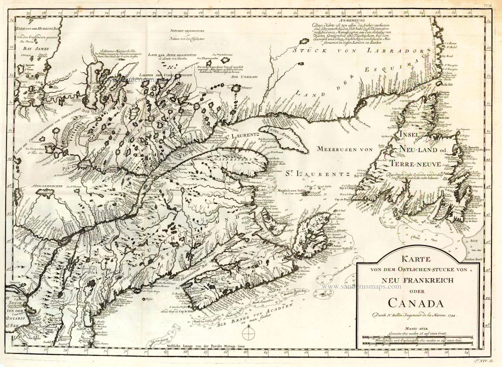
Karte von dem Ostlichen-Stucke von Neu Frankreich oder Canada. 1747-74
Eastern Canada, by Jacques Nicolas Bellin.
[Item number: 26796]
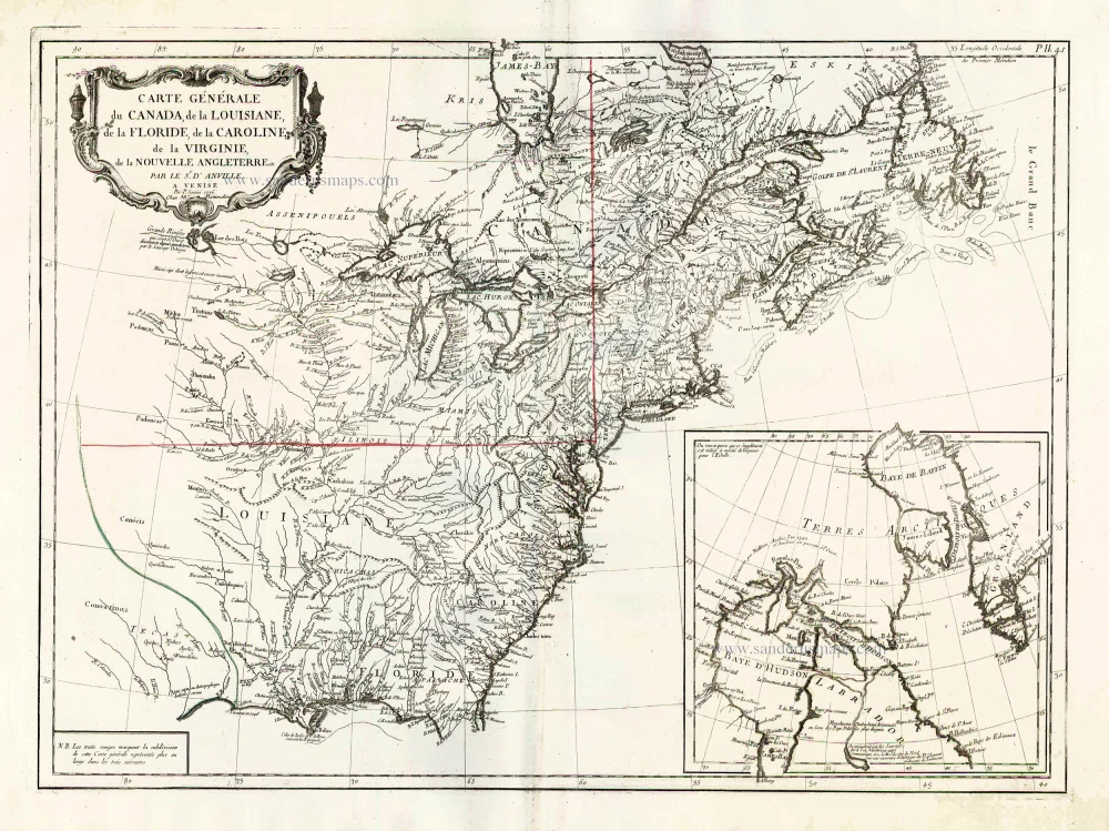
Carte Générale du Canada, de la Louisiane, de la Floride, de la Caroline, de la Virginie, de la Nouvelle Angleterre etc. 1776-79
North America (East), by Paolo Santini.
[Item number: 26980]

Partie Orientale du Canada, avec la Nouvelle Angleterre, l'Acadie, et la Terre-Neuve. 1776-79
New England and Northeastern Canada, by Paolo Santini.
[Item number: 26982]

Suite de la Carte Reduite du Golphe de St. Laurent Contenant les Costes de Labrador depuis Mecatina jusqu'a la Baye des Esquimaux le Detroit de Belle-Isle Et partie des Costes de l'Isle de Terre Neuve Connues sous le Nom du Petit Nord 1753
St. Lawrence River, by J.N. Bellin.
[Item number: 27914]

Septemtrionaliora Americae à Groenlandia, per Freta Davidis et Hudson, ad Terram Novam = De Noordelyckste Zee kusten van America van Goenland door de Straet Davis ende Straet Hudson tot Terra Neuf. c. 1690
North-Eastern Coasts of North America (Canada), by Frederick de Wit.
[Item number: 29242]

't Noorder Gedeelte van Virginie door Batholomeus Gosnol en Martin Pringe uyt Engeland bevaaren. 1707
North Atlantic Ocean showing the east coast of North America, Greenland, Iceland, Azores, and part of Europe/Africa, by Pieter Van der Aa.
[Item number: 32402]