
North America (Northeast), by A.M. Mallet. 1685

Allain Manesson Mallet (1630-1706)
Allain Manesson Mallet was born in 1630, the son of Philippe Mallet. His father was an ingénieur ordinaire to Louis XIV and a professor of mathematics around 1645. Allain, at first, carried muskets to the regiment of guards of Louis XIV and then became an engineer like his father. Later, becoming a sergeant-major of artillery, he travelled extensively to Spain and Portugal, supervising the fortifications there. On his return to France, he was named master of mathematics. In 1671, he published the Travaux de Mars, a book on military fortifications. He followed in 1683 with the work concerned here, the Description de l'Univers, a five-volume geographical text covering all subjects. It was heavily illustrated with nearly 700 prints and maps. (Burden)
Canada ou Nouvelle France.
Item Number: 26601 Authenticity Guarantee
Category: Antique maps > America > North America
Old, antique map of the northeast of North America, by A.M. Mallet.
Date of the first edition: 1683
Date of this map: 1685
Copper engraving, printed on paper.
Size (not including margins): 14 x 10cm (5.5 x 3.9 inches)
Verso: Blank
Condition: Excellent.
Condition Rating: A+
References: Burden, #565; Kershaw, #267; McCorkle, #683.3.
From: Beschreibung des ganzen Welt-Kreises. Frankfurt, 1685.
Allain Manesson Mallet (1630-1706)
Allain Manesson Mallet was born in 1630, the son of Philippe Mallet. His father was an ingénieur ordinaire to Louis XIV and a professor of mathematics around 1645. Allain, at first, carried muskets to the regiment of guards of Louis XIV and then became an engineer like his father. Later, becoming a sergeant-major of artillery, he travelled extensively to Spain and Portugal, supervising the fortifications there. On his return to France, he was named master of mathematics. In 1671, he published the Travaux de Mars, a book on military fortifications. He followed in 1683 with the work concerned here, the Description de l'Univers, a five-volume geographical text covering all subjects. It was heavily illustrated with nearly 700 prints and maps. (Burden)
Related items

Estotilandia et Laboratoris Terra. 1607
Greenland and Northeast Canada, by C. van Wytfliet.
[Item number: 26499]

Amerique Septentrionale. 1685
North America, by A.M. Mallet.
[Item number: 26643]
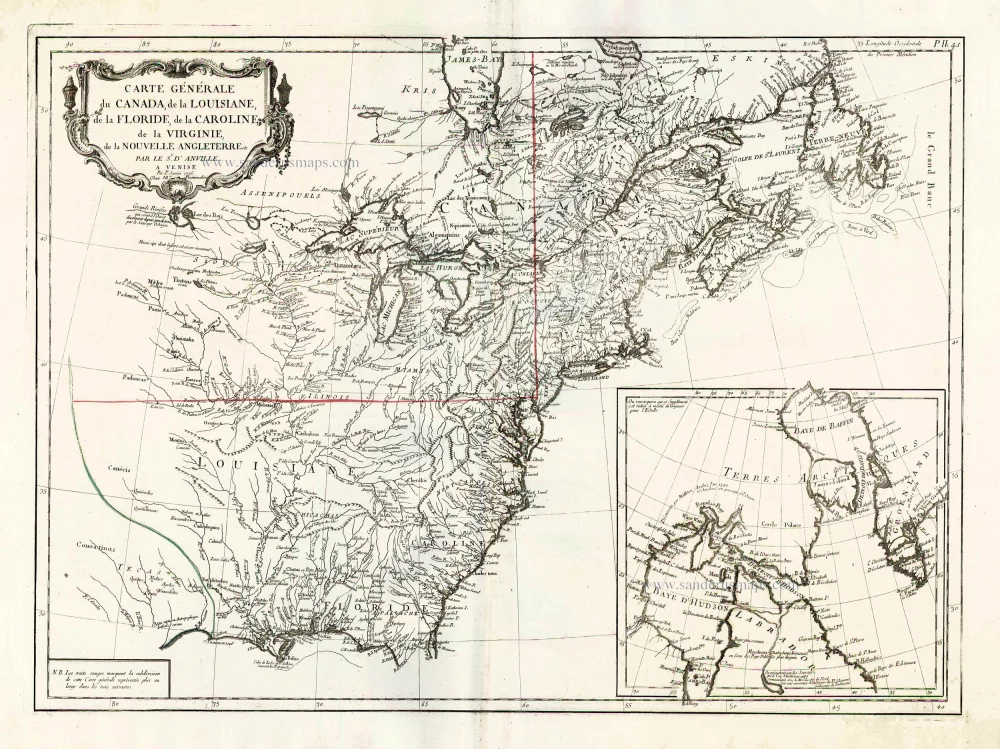
Carte Générale du Canada, de la Louisiane, de la Floride, de la Caroline, de la Virginie, de la Nouvelle Angleterre etc. 1776-79
North America (East), by Paolo Santini.
[Item number: 26980]

Partie Occidentale du Canada et Septentrionale de la Louisiane avec une Partie de la Pensilvani. 1776-79
Great Lakes, by Paolo Santini.
[Item number: 26981]
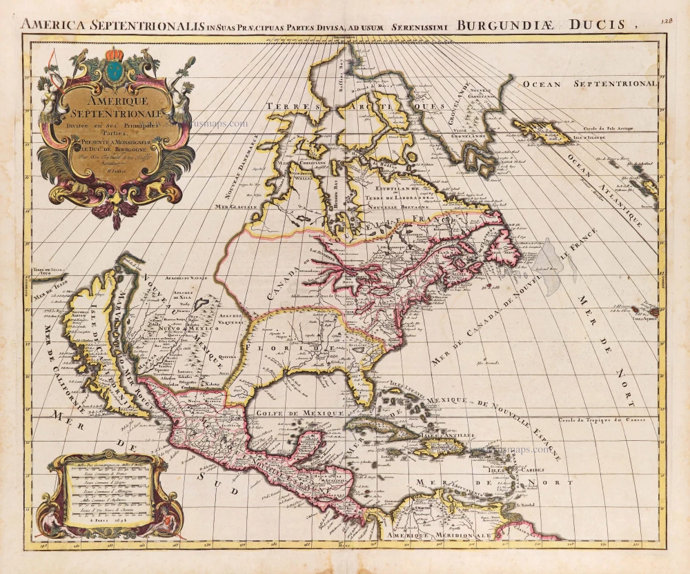
Amerique Septentrionale, Divisee en ses Principales Parties. 1694
North America, by Nicolas Sanson, published by Pierre Mortier after A.H. Jaillot.
[Item number: 29125]

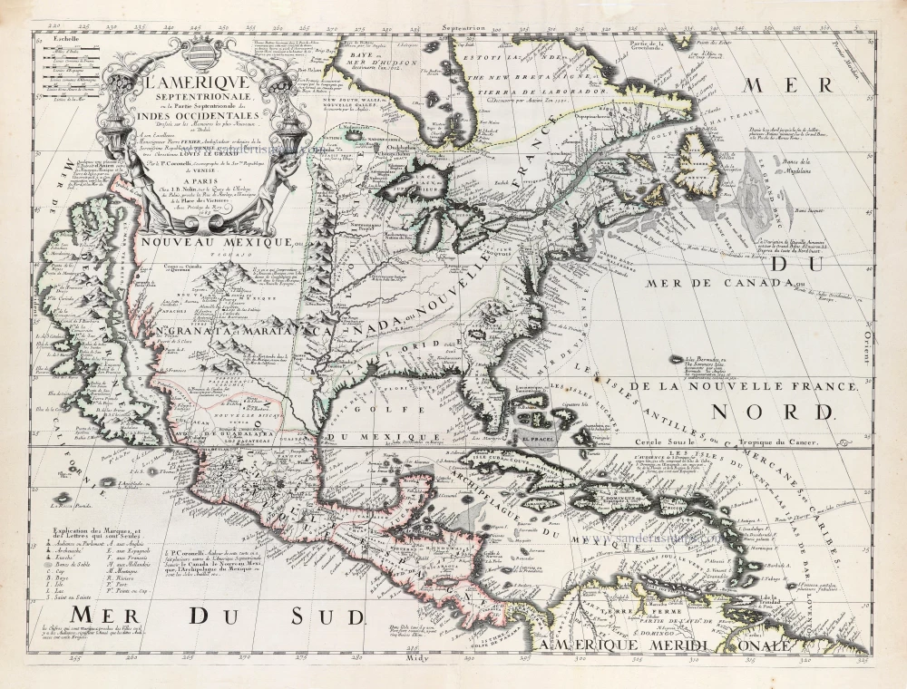
L'Amerique Septentrionale. 1708
North America by G. de L'Isle, published by Pierre Mortier.
[Item number: 29510]

Landmark map of North Amerika
Amerique Septentrionale. 1652
Nicolas Sanson's landmark map of North America, scarce second state.
[Item number: 29597]

California as an island.
L'Amerique Septentrionale qui fait partie des Indes Occidentales. 1719
North America by Chiquet Jacques.
[Item number: 30085]

California as an island.
Americque Septentrionale. 1715
North America by Nicolas Sanson, published by Nicolas Chemereau.
[Item number: 30086]

Carte d'Assemblage de l'Amérique Septen-le 1827
North America by Philippe Vandermaelen.
[Item number: 31099]

Amerique Septentrionale, Divisee en ses Principales Parties, ou sont Distingues les Uns des Autres les Estats Suivant qu'ils Appartiennent Presentemet aux Francois, Castillans, Anglois, Suedois, Danois, Hollandois. 1692
North America by N. Sanson, so-called published by Hubert Jaillot. (Pirated edition by Pierre Mortier).
[Item number: 31142]
Rare first edition of the important Coronelli-Nolin map of North America
L'Amerique Septentrionale, ou la Partie Septentrionale des Indes Occidentales. 1689
North and Central America by Vincenzo Coronelli, published by J.B. Nolin.
[Item number: 31338]

L' America Settentrionale. 1677
North America by Giovanni De Rossi, after Nicolas Sanson.
[Item number: 32889]