
Eastern Canada, by Jacques Nicolas Bellin. 1747-74
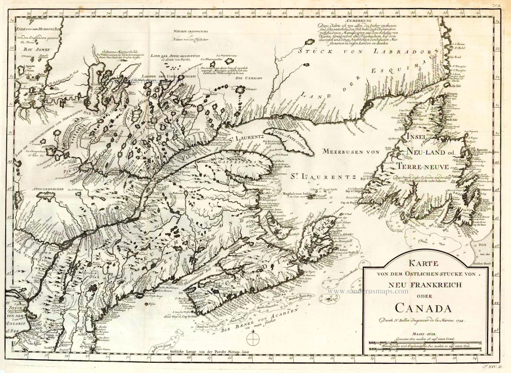
An important map that Bellin used subsequently as a base for his later maps of the area, and one that was also copied extensively by numerous other cartographers.
Jacques-Nicolas Bellin (1703-1772)
Jacques-Nicolas Bellin, a French geographer, was among the most important mapmakers of the eighteenth century. In 1721, at the age of 18, he was appointed hydrographer of the Ministry of the Navy following the French hydrographic office's creation and the Dépot of charts and plans of the Navy. Appointed hydrographic engineer in August 1741. Member of the Academy of the Navy and the Royal Society of London.
Over the course of a 50-year career, he drew the maps of several major works of his time such as Histoire et description générale de la Nouvelle-France de Charlevoix (1744); Histoire générale des voyages de l'Abbé Prévost (published between 1746 and 1759) ); Neptune François (1753), Hydrographie Françoise (1756-1765), and Petit Atlas Français (1763) - reissued as Petit Atlas Maritime (1765). He is the most copied cartographer of the 18th century.
His maps of Canada and the French territories of North America are of considerable value. This is all the more remarkable since, an archetype of the cabinet cartographer, Bellin never came to America. For his cartography of the St. Lawrence River, he entrusted handwritten maps to navigators to correct and enrich. With each return of these maps, he was updating his knowledge. Two basic needs drive its cartography of North America: to secure navigation on the St. Lawrence River and to claim for France the lands explored by the French in the Great Lakes region and along the Mississippi River.
Jacques-Nicolas Bellin died on March 21, 1772, in Versailles. In the burial certificate, he is described as "the first engineer of the navy and the deposit of plans, royal censor of the academy of navy and the royal society of London".
Karte von dem Ostlichen-Stucke von Neu Frankreich oder Canada.
Item Number: 26796 Authenticity Guarantee
Category: Antique maps > America > North America
Old, antique map of Eastern Canada, by Jacques Nicolas Bellin.
Date of the first edition: 1744
Date of this map: c. 1747
Date on map: 1744
Copper engraving, printed on paper.
Size (not including margins): 39.5 x 55.5cm (15.4 x 21.6 inches)
Verso: Blank
Condition: Excellent.
Condition Rating: A+
References: Kershaw, #686; McCorkle, 744.3.
From: Prevost d'Exiles. Allgemeine Historie der Reisen zu Wasser und Lande; oder Sammlung aller Reisebeschreibungen, welche bis itzo in verschiedene Sprachen von allen Völkern herausgegeben worden, ... Leipzig, Arkstee und Merkus, 1747-74.
An important map that Bellin used subsequently as a base for his later maps of the area, and one that was also copied extensively by numerous other cartographers.
An important map that Bellin used subsequently as a base for his later maps of the area, and one that was also copied extensively by numerous other cartographers.
Jacques-Nicolas Bellin (1703-1772)
Jacques-Nicolas Bellin, a French geographer, was among the most important mapmakers of the eighteenth century. In 1721, at the age of 18, he was appointed hydrographer of the Ministry of the Navy following the French hydrographic office's creation and the Dépot of charts and plans of the Navy. Appointed hydrographic engineer in August 1741. Member of the Academy of the Navy and the Royal Society of London.
Over the course of a 50-year career, he drew the maps of several major works of his time such as Histoire et description générale de la Nouvelle-France de Charlevoix (1744); Histoire générale des voyages de l'Abbé Prévost (published between 1746 and 1759) ); Neptune François (1753), Hydrographie Françoise (1756-1765), and Petit Atlas Français (1763) - reissued as Petit Atlas Maritime (1765). He is the most copied cartographer of the 18th century.
His maps of Canada and the French territories of North America are of considerable value. This is all the more remarkable since, an archetype of the cabinet cartographer, Bellin never came to America. For his cartography of the St. Lawrence River, he entrusted handwritten maps to navigators to correct and enrich. With each return of these maps, he was updating his knowledge. Two basic needs drive its cartography of North America: to secure navigation on the St. Lawrence River and to claim for France the lands explored by the French in the Great Lakes region and along the Mississippi River.
Jacques-Nicolas Bellin died on March 21, 1772, in Versailles. In the burial certificate, he is described as "the first engineer of the navy and the deposit of plans, royal censor of the academy of navy and the royal society of London".
Related items

Estotilandia et Laboratoris Terra. 1607
Greenland and Northeast Canada, by C. van Wytfliet.
[Item number: 26499]

Partie Orientale du Canada, avec la Nouvelle Angleterre, l'Acadie, et la Terre-Neuve. 1776-79
New England and Northeastern Canada, by Paolo Santini.
[Item number: 26982]

Suite de la Carte Reduite du Golphe de St. Laurent Contenant les Costes de Labrador depuis Mecatina jusqu'a la Baye des Esquimaux le Detroit de Belle-Isle Et partie des Costes de l'Isle de Terre Neuve Connues sous le Nom du Petit Nord 1753
St. Lawrence River, by J.N. Bellin.
[Item number: 27914]

Carte Réduite du Golphe de St. Laurent Contenant l'Isle de Terre-Neuve et Partie de la Coste des Esquimaux l'Isle Royale, l'Isle St. Jean et celle d'Anticosti &ca. 1754
St. Lawrence Gulf, by Jacques Nicholas Bellin.
[Item number: 27915]

Septemtrionaliora Americae à Groenlandia, per Freta Davidis et Hudson, ad Terram Novam = De Noordelyckste Zee kusten van America van Goenland door de Straet Davis ende Straet Hudson tot Terra Neuf. c. 1690
North-Eastern Coasts of North America (Canada), by Frederick de Wit.
[Item number: 29242]

't Noorder Gedeelte van Virginie door Batholomeus Gosnol en Martin Pringe uyt Engeland bevaaren. 1707
North Atlantic Ocean showing the east coast of North America, Greenland, Iceland, Azores, and part of Europe/Africa, by Pieter Van der Aa.
[Item number: 32402]