
Early 'Texas' map
North America, by Girolamo Ruscelli. 1574

Girolamo Ruscelli (1504 (1518?) -1566)
Girolamo Ruscelli was an Italian mathematician and cartographer who worked in Venice in the early 16th century. He was also an alchemist who wrote pseudonymously as Alessio Piemontese.
He published a translation of the Geografia of Ptolemy, printed in Venice by Vincenzo Valgrisi in 1561. It was a quarto edition with Ptolemaic and modern maps. The engravers may have been the brothers Giulio and Livio Sanuto. Among the 69 copperplate maps were 40 based on maps by Giacomo Gastaldi. The maps were re-issued in 1562, 1564, 1574 and 1598.
Nueva Hispania Tabula Nova.
Item Number: 27755 Authenticity Guarantee
Category: Antique maps > America > Central America
Title: Nueva Hispania Tabula Nova.
Cartographer: Giacomo Gastaldi.
Date of the first edition: 1561.
Date of this map: 1574.
Copper engraving, printed on paper.
Size (not including margins): 150 x 260mm (5.91 x 10.24 inches).
Verso: Italian text.
Condition: Excellent.
Condition Rating: A.
From: La Geografia di Claudio Tolomeo Alessandrino. Venice, 1574.
Girolamo Ruscelli (1504 (1518?) -1566)
Girolamo Ruscelli was an Italian mathematician and cartographer who worked in Venice in the early 16th century. He was also an alchemist who wrote pseudonymously as Alessio Piemontese.
He published a translation of the Geografia of Ptolemy, printed in Venice by Vincenzo Valgrisi in 1561. It was a quarto edition with Ptolemaic and modern maps. The engravers may have been the brothers Giulio and Livio Sanuto. Among the 69 copperplate maps were 40 based on maps by Giacomo Gastaldi. The maps were re-issued in 1562, 1564, 1574 and 1598.
Related items

Limes Occidentis Quivira et Anian. 1607
West coast by Wytfliet, Cornelis van
[Item number: 26513]

Canada ou Nouvelle France. 1685
North America (Northeast), by A.M. Mallet.
[Item number: 26601]

Amerique Septentrionale. 1685
North America, by A.M. Mallet.
[Item number: 26643]

Karte von Nord-America, zur Geschichte von Neu-Frankreich. 1747-74
North America, by Jacques Nicolas Bellin.
[Item number: 26799]
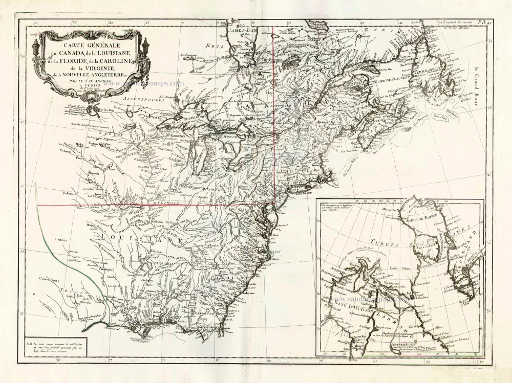
Carte Générale du Canada, de la Louisiane, de la Floride, de la Caroline, de la Virginie, de la Nouvelle Angleterre etc. 1776-79
North America (East), by Paolo Santini.
[Item number: 26980]

Earliest obtainable map of North America
Mondo Nuovo - Descrittione del l'Isola et Terra di Sancta Croce, overo Mondo Nuovo. 1576
Tomaso Porcacchi., North America
[Item number: 27651]

Amerique Septentrionale. 1748
North America by Robert de Vaugondy.
[Item number: 28157]
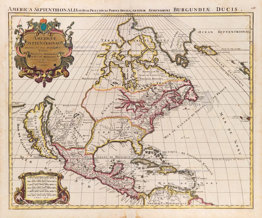
Amerique Septentrionale, Divisee en ses Principales Parties. 1694
North America, by Nicolas Sanson, published by Pierre Mortier after A.H. Jaillot.
[Item number: 29125]

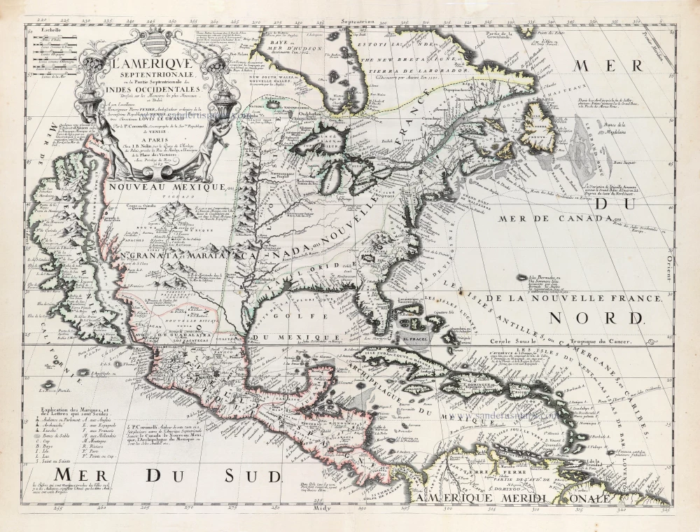
L'Amerique Septentrionale. 1708
North America by G. de L'Isle, published by Pierre Mortier.
[Item number: 29510]

Landmark map of North Amerika
Amerique Septentrionale. 1652
Nicolas Sanson's landmark map of North America, scarce second state.
[Item number: 29597]

Big and spectacular map, heightened in gold.
Amerique Septentrionale, divisée en ses principales parties, ou sont distingués les uns des autres Les Estats suivant qu'ils appartiennet Presentemet aux Francois, Castillans, Anglois, Suedois, Danois, Hollandois. 1692
North America by N. Sanson, so-called published by Hubert Jaillot. (Pirated edition by Pierre Mortier).
[Item number: 29895]

California as an island.
L'Amerique Septentrionale qui fait partie des Indes Occidentales. 1719
North America by Chiquet Jacques.
[Item number: 30085]

California as an island.
Americque Septentrionale. 1715
North America by Nicolas Sanson, published by Nicolas Chemereau.
[Item number: 30086]

From 'Diderot & d'Alembert'
Carte de la Californie Suivant I. La Carte manuscrite de l'Amérique de Mathieu Néron Pecci olen dresses à Florence en 1604. II. Sanson 1656. III. De l'Isle Amérique Sept. 1700. IV. le Pere Kino Jesuite en 1705. V. la Société des Jésuites en 1767. 1777
California by Robert de Vaugondy.
[Item number: 30091]

Carte de la Partie de l'Amérique Septentrionale, comprenant les Possessions Espagnoles. 1788
North America by Louis Brion de la Tour.
[Item number: 30144]

Carte d'Assemblage de l'Amérique Septen-le 1827
North America by Philippe Vandermaelen.
[Item number: 31099]

Amerique Septentrionale, Divisee en ses Principales Parties, ou sont Distingues les Uns des Autres les Estats Suivant qu'ils Appartiennent Presentemet aux Francois, Castillans, Anglois, Suedois, Danois, Hollandois. 1692
North America by N. Sanson, so-called published by Hubert Jaillot. (Pirated edition by Pierre Mortier).
[Item number: 31142]
Rare first edition of the important Coronelli-Nolin map of North America
L'Amerique Septentrionale, ou la Partie Septentrionale des Indes Occidentales. 1689
North and Central America by Vincenzo Coronelli, published by J.B. Nolin.
[Item number: 31338]

L' America Settentrionale. 1677
North America by Giovanni De Rossi, after Nicolas Sanson.
[Item number: 32889]