
South America by Nicolas Sanson, published by Giovanni de Rossi. 1677

de Rossi Family
Seventeenth-century Rome was home to the famous publishing house of de Rossi. Two branches of the family used the addresses in Piazza Navona and Piazza della Pace; the latter was the more important house. Giuseppe de Rossi founded the house in 1613 and continued until he died in 1639. Giovanni Giacomo de Rossi flourished from 1649 to 1691. In 1677, he published a folio atlas titled Mercurio Geografico. It was drawn almost entirely from the cartography of the Sanson family in Paris. Whether it was with their permission or simple plagiarism is unknown, but they are credited. (Burden)
Giuseppe Rossi (flourished 1613-1639), Publisher at 'Piazza della Pace'.
Giovanni Giacomo de Rossi (1627-1691), Printer and publisher at 'Alla Pace all'insegna di Parigi', Rome.
Domenico de Rossi (flourished c. 1691-c. 1720), Successor to Giovanni Giacomo Rossi.
Lorenzo Filippo Rossi (flourished c. 1720-1738). Successor to Domenico.
In 1738, the Rossi plates were sold to the government of the Papal States.
SANSON FAMILY
Nicolas Sanson (1600-1667) - Guillaume Sanson (1633-1703) - Pierre Moullart-Sanson (? -1730)
Originally from Abbeville, Nicolas I Sanson showed a keen interest in historical geography. He was still very young; he published a map of ancient Gaul and two treatises, Britannia and Portus Itius on Abbeville and Boulogne's origins. His meeting with Melchior Tavernier was decisive: it prompted him to give up his duties as a military engineer in Picardy and devote himself to engraved cartography.
At the same time, Sanson had drawn up the outline of modern France. He got the help of Tavernier, who encouraged him to compete with the Dutch map publishers. Tavernier contacted other French cartographers whose works he published.
From 1643, N. Sanson obtained a privilege to publish a work personally, the Princes souverains de l'Italie. Then, in 1644 and 1645, he had his famous geographical tables printed, which significantly contributed to his fame. He also published a series of atlases in quarto of the four continents.
In 1648, N. Sanson associated himself with Mariette to publish atlases. From then on, specific maps bore his name and others Mariette's. N. Sanson and Mariette worked together for more than 20 years. After the death of N. Sanson, Mariette acquired the entire fund. Since Mariette only wanted to publish complete atlases, individual maps were no longer sold, and some army generals complained to the king.
The disagreement between the Sanson family and Pierre II Mariette culminated in 1671 when Guillaume Sanson took the case to court. There was no longer any question of collaboration: Guillaume Sanson started working for another publisher, Alexis-Hubert Jaillot.
The Sanson family faced financial difficulties, and in 1692, their cousin, Pierre Moullart-Sanson, bought the entire geographic fund from his uncles and aunt. Pierre Moullart-Sanson was the son of Françoise Sanson (third child of Nicolas) and Pierre Moullart. He restarted the publishing of Sanson's world atlas, and in 1704 he acquired a privilege for publishing all the works of Nicolas and Guillaume Sanson, which continued to be published until 1730.
L' America Meridionale.
Item Number: 32897 Authenticity Guarantee
Category: Antique maps > America > South America
South America by Nicolas Sanson, published by Giovanni de Rossi.
Title: L' America Meridionale.
Nuovamente corretta, et accresciuta, secondo le relationi più moderne da Guglielmo Sansone Geografo di S.M. Christianis[sim]a.
E data in luce da Gio. Giacomo de Rossi, in Roma, nella sua Stamperia alla Pace, l'Anno 1677.
Giorgio Widman sculp.
Cartographer: Nicolas Sanson.
Engraver: Georgio Widman.
Date of the first edition: 1677.
Date of this map: 1677.
Date on map: 1677.
First state.
Copper engraving, printed on paper.
Image size: 400 x 550mm (15¾ x 21¾ inches).
Sheet size: 480 x 600mm (19 x 23½ inches).
Verso: Blank.
Condition: Original coloured in outline, excellent.
Condition Rating: A+.
From: Mercurio Geografico overo Guida Geografica in Tutte le Parti di Mondo Conforme le Tavoile Geogrfiche del Sansone Baudrand e Cantelli. Data in luce con direttione, e cura di G.G. de Rossi. Rome, 1677.
de Rossi Family
Seventeenth-century Rome was home to the famous publishing house of de Rossi. Two branches of the family used the addresses in Piazza Navona and Piazza della Pace; the latter was the more important house. Giuseppe de Rossi founded the house in 1613 and continued until he died in 1639. Giovanni Giacomo de Rossi flourished from 1649 to 1691. In 1677, he published a folio atlas titled Mercurio Geografico. It was drawn almost entirely from the cartography of the Sanson family in Paris. Whether it was with their permission or simple plagiarism is unknown, but they are credited. (Burden)
Giuseppe Rossi (flourished 1613-1639), Publisher at 'Piazza della Pace'.
Giovanni Giacomo de Rossi (1627-1691), Printer and publisher at 'Alla Pace all'insegna di Parigi', Rome.
Domenico de Rossi (flourished c. 1691-c. 1720), Successor to Giovanni Giacomo Rossi.
Lorenzo Filippo Rossi (flourished c. 1720-1738). Successor to Domenico.
In 1738, the Rossi plates were sold to the government of the Papal States.
SANSON FAMILY
Nicolas Sanson (1600-1667) - Guillaume Sanson (1633-1703) - Pierre Moullart-Sanson (? -1730)
Originally from Abbeville, Nicolas I Sanson showed a keen interest in historical geography. He was still very young; he published a map of ancient Gaul and two treatises, Britannia and Portus Itius on Abbeville and Boulogne's origins. His meeting with Melchior Tavernier was decisive: it prompted him to give up his duties as a military engineer in Picardy and devote himself to engraved cartography.
At the same time, Sanson had drawn up the outline of modern France. He got the help of Tavernier, who encouraged him to compete with the Dutch map publishers. Tavernier contacted other French cartographers whose works he published.
From 1643, N. Sanson obtained a privilege to publish a work personally, the Princes souverains de l'Italie. Then, in 1644 and 1645, he had his famous geographical tables printed, which significantly contributed to his fame. He also published a series of atlases in quarto of the four continents.
In 1648, N. Sanson associated himself with Mariette to publish atlases. From then on, specific maps bore his name and others Mariette's. N. Sanson and Mariette worked together for more than 20 years. After the death of N. Sanson, Mariette acquired the entire fund. Since Mariette only wanted to publish complete atlases, individual maps were no longer sold, and some army generals complained to the king.
The disagreement between the Sanson family and Pierre II Mariette culminated in 1671 when Guillaume Sanson took the case to court. There was no longer any question of collaboration: Guillaume Sanson started working for another publisher, Alexis-Hubert Jaillot.
The Sanson family faced financial difficulties, and in 1692, their cousin, Pierre Moullart-Sanson, bought the entire geographic fund from his uncles and aunt. Pierre Moullart-Sanson was the son of Françoise Sanson (third child of Nicolas) and Pierre Moullart. He restarted the publishing of Sanson's world atlas, and in 1704 he acquired a privilege for publishing all the works of Nicolas and Guillaume Sanson, which continued to be published until 1730.
Related items

Carte Particuliere du Perou, de la Ville de Lima. 1713-1719
South America (Northwest), by Zacharias Châtelain.
[Item number: 16838]

Important and rare map
Brasilia et Peruvia ... 1593
South America, by Cornelis de Jode.
[Item number: 25240]

Very rare first state
Neuwe Landtaffel, in welcher eigentlich, und warhafftiglich furgestelt wird, das gewaltige und goldtreiche Kunigreich Guiana : so daligt under der aequinoctial Linien zwischer Brasilien und Peru / observiert und abgerisen von ein emschiffman so selbst mit her Ralegh der fahrt gewessen. 1599
Guyana by Theodor de Bry.
[Item number: 27037]

La Partie Méridionale De L'Amérique Appeéee Terre Ferme ou se trouve Les Provinces ou Grand Gouvernemens de La Guiane et de La Nouvelle Grenade . . . 1709-28
Northern South America, by Nicolas de Fer.
[Item number: 27572]

Le Paraguayr, Le Chili, la Terre, et les Isles Magellanicques. 1692
Southern South America by Nicolas Sanson.
[Item number: 28502]

Partie de Terre Ferme ou sont Guiane et Caribane. 1658
Guiana by Nicolas Sanson.
[Item number: 28504]
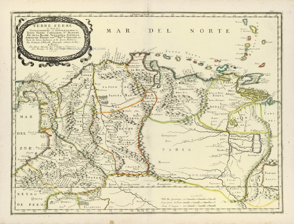
Terre Ferme ou sont les Governations, ou Gouvernemens de Terre Ferme, Cartagene, Ste. Marthe, Rio de la Hache, Venezuela, Nouvelle Andalusie, Popayan, Nouveau Roy[au]me de Grenade, &c. 1658
Northern South America by Nicolas Sanson.
[Item number: 28505]

La Terre et les Isles Magellaniques. 1670
Southern South America with the Straits of Magellan, by Guillaume Sanson.
[Item number: 28510]

L'Amerique Meridionale Divisee en ses Principales Parties. [Above map:] America Meridionalis in suas Praecipuas Partes Accurate Divisa, ad Usum Serenissimi Burgundiae Ducis. c. 1691-97
South America, by Hubert Jaillot.
[Item number: 29153]

Tractus Australior Americae Meridionalis, a Rio del a Plata per Fretum Magellanicum ad Toraltum. = Nieuwe Perfecte Pascaert van 't Suyderlyckste deel van Suyt America. van Rio de la Plata door de straet Magellaen tot Toral. c. 1690-91
Sea chart of the Southern Coasts of South America, by Frederick de Wit.
[Item number: 29239]

Carte du Paraguai, du Chili, du Detroit de Magellan &c. 1719
Southern South America, by Zacharias Châtelain.
[Item number: 29361]
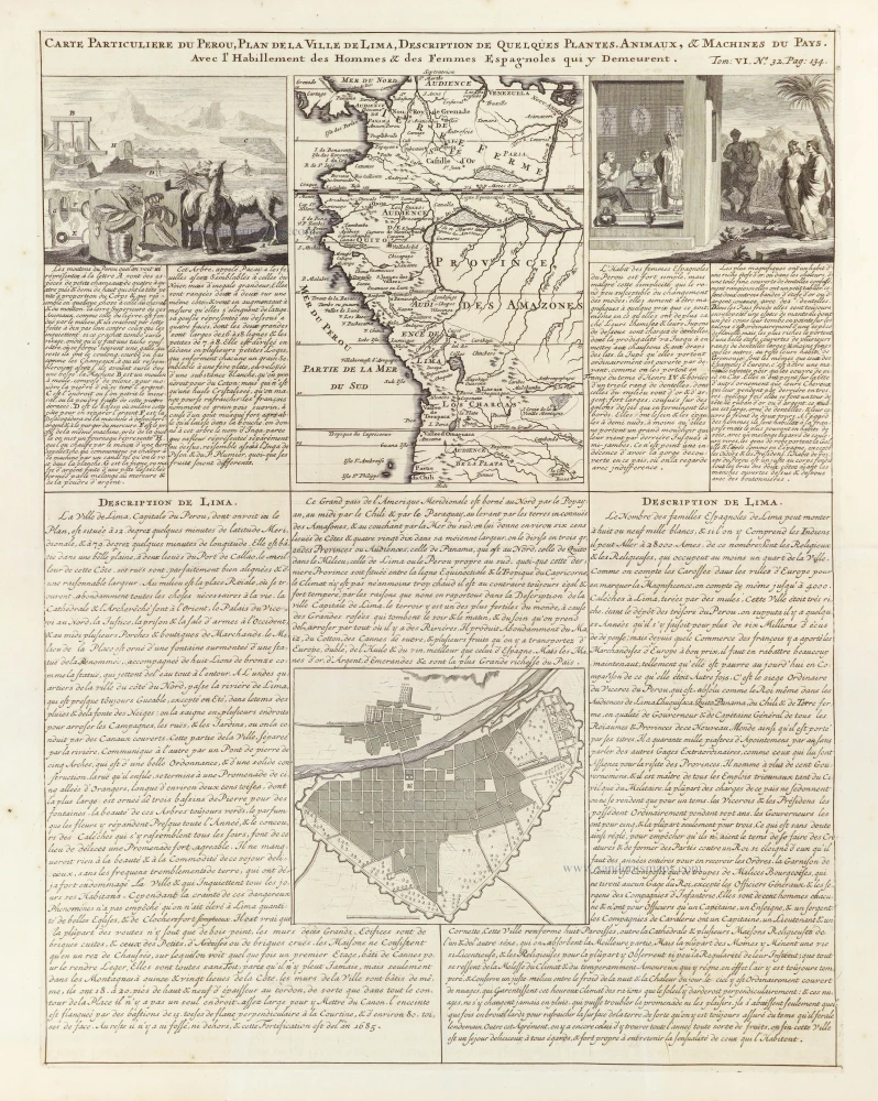
Carte Particuliere du Perou, Plan de la Ville de Lima, Description de quelques plantes, animaux, & Machines du Pays. 1719
Northwest South America, by Zacharias Châtelain.
[Item number: 29363]

Amerique Meridionale Divisée en ses Principales Parties ou sont Distingués les uns des Autres les Estats Suivant qu'ils appartienent présentement, aux François, Castillans, Portugais, Hollandois, &c. 1692
South America by N. Sanson, so-called published by Hubert Jaillot. (Pirated edition by Pierre Mortier).
[Item number: 31143]
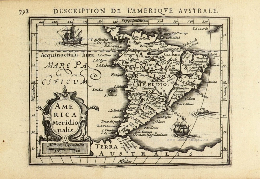
America Meridionalis. 1618
South America, by Petrus Bertius.
[Item number: 32335]