
Pacific Ocean by Coronelli V.M. 1691
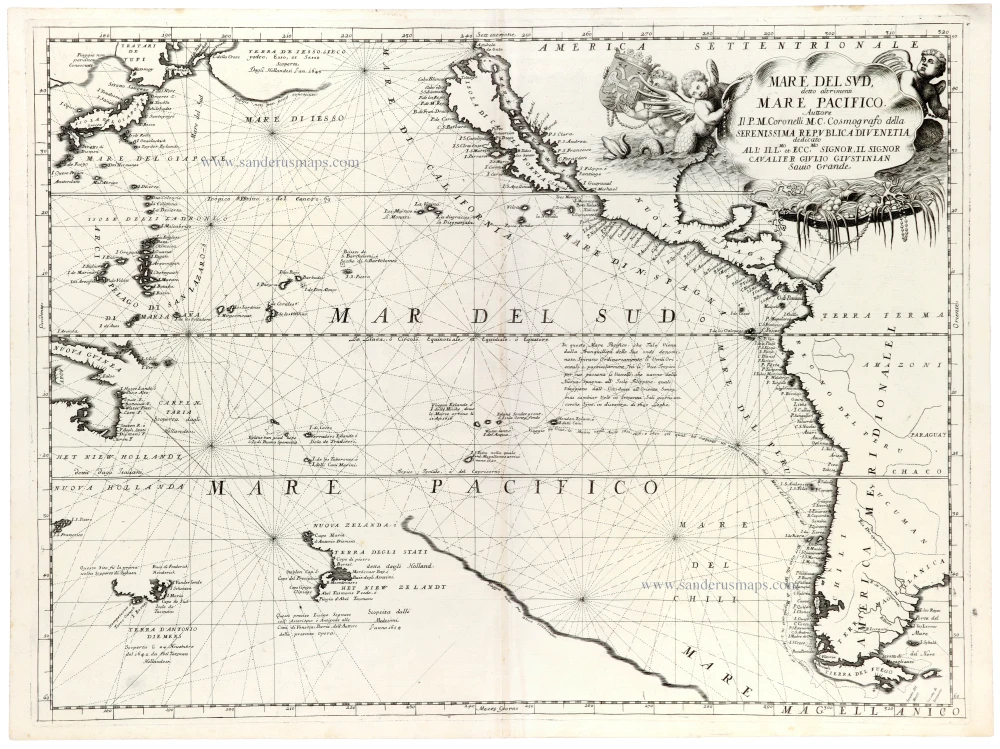
A magnificent and highly decorative map of the Pacific Ocean by Vincenzo Maria Coronelli, one of the most celebrated Venetian cartographers of the late seventeenth century. Published in his Atlante Veneto in 1691, the map shows the Pacific Ocean stretching from the eastern coasts of Asia and Australia to the western shores of North and South America, reflecting European geographical knowledge and exploration at the end of the seventeenth century.
The map is particularly remarkable for its depiction of Australia and the islands of the South Pacific. Australia, still only partially explored by Europeans, appears as Nuova Hollandia, with its western and northern coastlines based largely on seventeenth-century Dutch discoveries. Tasmania is shown as Terra d'Antonio Diemens, while New Zealand (Nuova Zelanda) appears with an incomplete coastline, reflecting Abel Tasman's voyages of 1642–1643. The large unexplored spaces between these landmasses illustrate the considerable uncertainty that still surrounded the geography of the southern Pacific.
In the northern Pacific, Coronelli depicts Japan, the Kuril Islands and the northeastern coastline of Asia, together with the western coast of North America. California is prominently represented as an island, reflecting one of the most persistent geographical misconceptions in seventeenth-century cartography. Although California had already been correctly depicted as a peninsula on earlier maps, the erroneous insular representation remained widespread throughout much of the seventeenth century and well into the eighteenth century.
Numerous islands and archipelagos are identified throughout the Pacific, including the Philippines, the Mariana Islands and various island groups associated with the voyages of Spanish and Dutch navigators. The map is covered with an intricate network of rhumb lines radiating from numerous compass centres, recalling the tradition of nautical charts and emphasising the composition's maritime character.
Of particular interest is the extensive representation of the Pacific coast of South America, with numerous coastal settlements and geographical features identified along the shores of Peru and Chile. The map also preserves several speculative geographical features and incomplete coastlines, characteristic of the transitional period between the great Dutch voyages of discovery and the systematic exploration of the Pacific during the eighteenth century.
The exceptionally elaborate title cartouche in the upper right is adorned with putti, marine creatures, shells and luxuriant ornamental elements. It bears a dedication to Cavaliere Giulio Giustiniani, a member of the distinguished Venetian patrician family. The rich Baroque decoration is characteristic of Coronelli's finest cartographic productions.
An impressive and historically important map of the Pacific Ocean, documenting the state of European geographical knowledge before the great eighteenth-century voyages of exploration, and a fine example of Coronelli's celebrated Baroque cartography.
Vincenzo Coronelli (1650-1718)
Vincenzo Coronelli was born in Venice on 16 August 1650 and primarily brought up in Ravenna. He returned to Venice in 1665 and joined the convent of the Minor Conventuals. Five years later, he was sent to Rome to study, and by 1673, he was already a doctor of theology.
Having achieved fame by constructing two globes for the Duke of Parma, he was invited to Paris for three years in 1681 and made two enormous examples for Louis XIV. On his return to Venice, he assiduously collected cartographic material and founded the Academy of the Argonauts. In 1685, he was appointed Cosmographer to the Republic of Venice and authorised to publish a large atlas. He became a geography lecturer at the University of Venice and brought out an Atlante Veneto the following year.
In 1696, he visited Germany, Holland and southern England. During intervals in compiling his vast encyclopaedia, he continued with cartographic projects up to 1709. He died in his native Venice on 9 December 1718.
Coronelli became famous for his globes. In addition, he was a renowned encyclopaedist, mapmaker and geographer. Most of his maps and other material are gathered in his Atlante Veneto (13 vols, 1690-1705). The first volume, subtitled Descrizione generale istorica geografica, was his masterpiece, planned as an extension of Blaeu’s atlas.
Other volumes of the atlas which contain maps are Isolario, two parts (1696-8), with detailed maps and plans, mostly of islands; Corso geografico, two parts based on the edition 1694-7; Libro de’ globi (1697); and Lo Specchio del Mare, a reprint of Levanto's Lo Specchio del Mare Mediterraneo of 1664.
The other vital aspects of his mapping are those arising from the Venetian conquest and his travels. His most extensive military compilation was the Teatro della Guerra, in more than 30 volumes.
Mare del Sud, detto Altrimenti Mare Pacifico.
Item Number: 33409 new Authenticity Guarantee
Category: Antique maps > America > The Americas
Pacific Ocean by Coronelli V.M.
Title: Mare del Sud, detto Altrimenti Mare Pacifico.
Auttore Il P.M. Coronelli M.C. Cosmografo della Serenissima Republica di Venetia.
Date: 1691.
Copper engraving, printed on paper.
Image size: 450 x 600mm (17¾ x 23½ inches).
Sheet size: 475 x 640mm (18¾ x 25¼ inches).
Verso: Blank.
Condition: Excellent.
Condition Rating: A+.
From: Atlante Veneto, nel quale si contiene la descrittione... degl' Imperii, Regni, Provincie, e Stati dell' Universo. Venice: Girolamo Albrizzi, 1691. Shirley (Brit.Lib.), T.CORO-7a
A magnificent and highly decorative map of the Pacific Ocean by Vincenzo Maria Coronelli, one of the most celebrated Venetian cartographers of the late seventeenth century. Published in his Atlante Veneto in 1691, the map shows the Pacific Ocean stretching from the eastern coasts of Asia and Australia to the western shores of North and South America, reflecting European geographical knowledge and exploration at the end of the seventeenth century.
The map is particularly remarkable for its depiction of Australia and the islands of the South Pacific. Australia, still only partially explored by Europeans, appears as Nuova Hollandia, with its western and northern coastlines based largely on seventeenth-century Dutch discoveries. Tasmania is shown as Terra d'Antonio Diemens, while New Zealand (Nuova Zelanda) appears with an incomplete coastline, reflecting Abel Tasman's voyages of 1642–1643. The large unexplored spaces between these landmasses illustrate the considerable uncertainty that still surrounded the geography of the southern Pacific.
In the northern Pacific, Coronelli depicts Japan, the Kuril Islands and the northeastern coastline of Asia, together with the western coast of North America. California is prominently represented as an island, reflecting one of the most persistent geographical misconceptions in seventeenth-century cartography. Although California had already been correctly depicted as a peninsula on earlier maps, the erroneous insular representation remained widespread throughout much of the seventeenth century and well into the eighteenth century.
Numerous islands and archipelagos are identified throughout the Pacific, including the Philippines, the Mariana Islands and various island groups associated with the voyages of Spanish and Dutch navigators. The map is covered with an intricate network of rhumb lines radiating from numerous compass centres, recalling the tradition of nautical charts and emphasising the composition's maritime character.
Of particular interest is the extensive representation of the Pacific coast of South America, with numerous coastal settlements and geographical features identified along the shores of Peru and Chile. The map also preserves several speculative geographical features and incomplete coastlines, characteristic of the transitional period between the great Dutch voyages of discovery and the systematic exploration of the Pacific during the eighteenth century.
The exceptionally elaborate title cartouche in the upper right is adorned with putti, marine creatures, shells and luxuriant ornamental elements. It bears a dedication to Cavaliere Giulio Giustiniani, a member of the distinguished Venetian patrician family. The rich Baroque decoration is characteristic of Coronelli's finest cartographic productions.
An impressive and historically important map of the Pacific Ocean, documenting the state of European geographical knowledge before the great eighteenth-century voyages of exploration, and a fine example of Coronelli's celebrated Baroque cartography.
Vincenzo Coronelli (1650-1718)
Vincenzo Coronelli was born in Venice on 16 August 1650 and primarily brought up in Ravenna. He returned to Venice in 1665 and joined the convent of the Minor Conventuals. Five years later, he was sent to Rome to study, and by 1673, he was already a doctor of theology.
Having achieved fame by constructing two globes for the Duke of Parma, he was invited to Paris for three years in 1681 and made two enormous examples for Louis XIV. On his return to Venice, he assiduously collected cartographic material and founded the Academy of the Argonauts. In 1685, he was appointed Cosmographer to the Republic of Venice and authorised to publish a large atlas. He became a geography lecturer at the University of Venice and brought out an Atlante Veneto the following year.
In 1696, he visited Germany, Holland and southern England. During intervals in compiling his vast encyclopaedia, he continued with cartographic projects up to 1709. He died in his native Venice on 9 December 1718.
Coronelli became famous for his globes. In addition, he was a renowned encyclopaedist, mapmaker and geographer. Most of his maps and other material are gathered in his Atlante Veneto (13 vols, 1690-1705). The first volume, subtitled Descrizione generale istorica geografica, was his masterpiece, planned as an extension of Blaeu’s atlas.
Other volumes of the atlas which contain maps are Isolario, two parts (1696-8), with detailed maps and plans, mostly of islands; Corso geografico, two parts based on the edition 1694-7; Libro de’ globi (1697); and Lo Specchio del Mare, a reprint of Levanto's Lo Specchio del Mare Mediterraneo of 1664.
The other vital aspects of his mapping are those arising from the Venetian conquest and his travels. His most extensive military compilation was the Teatro della Guerra, in more than 30 volumes.
Related items

Carte des Nouvelles Decouvertes au Nord de la Mer du Sud, tant à l'Est de la Sibérie et du Kamtchatka, qu'à l'Ouest de la Nouvelle France. 1776-79
Pacific Ocean (North) by Francesco & Paolo Santini
[Item number: 26979]

California as an island
Atlantis Insula. 1692
The Americas by Guillaume Sanson.
[Item number: 28376]

Novae Hispaniae, Chili, Peruviae, et Guatimalae Littorae. ca. 1680
Pacific Coast of America, by Frederick de Wit.
[Item number: 29177]

One of the most elaborately engraved maps ever published.
Carte tres Curieuse de la Mer du Sud, Contenant des Remarques Nouvelles et tres Utiles non Seulement sur les Ports et Iles de cette Mer, 1719
Pacific by Zacharias Châtelain after Nicolas de Fer.
[Item number: 29466]

Carte de la Mer du Sud ou Mer Pacifique. Entre l'Equateur et le 39.5 de Latitude septentrion.le. 1748
Map of the southern Pacific, showing a part of the path of George Anson's voyage around the world.
[Item number: 30330]
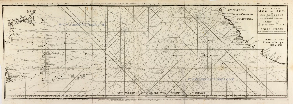
Carte de la Mer du Sud ou Mer Pacifique entre l'Equateur et le 39.5 de Latitude Septentrionale. - Kaart van de Zuyd-Zee of Stille Oceaan ... 1751
Map of the southern Pacific, showing a part of the path of George Anson's voyage around the world.
[Item number: 30609]
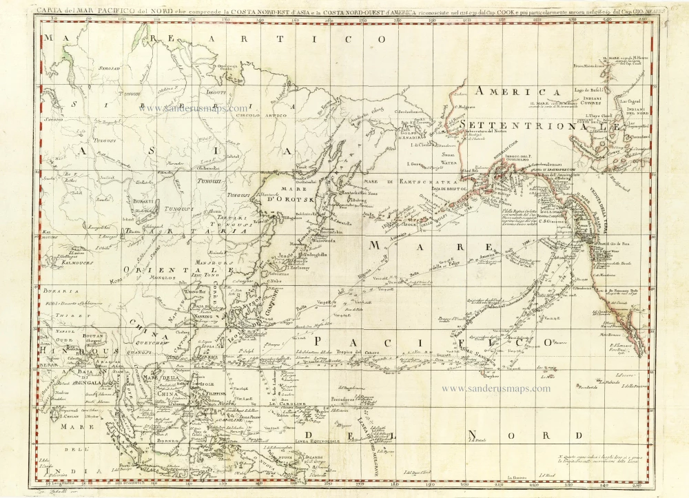
Carta del Mar Pacifico del Nord che comprende la Costa Nord-Ouest d'America 1796
Chart of the Northern Pacific Ocean, Northeastern Asia, and Alaska by John Meares.
[Item number: 30731]

Important map
Maris Pacifici, (quod vulgo Mar del Zur) cum regionibus circumiacentibus, insulisque in codem passim sparsis, novissima descriptio. 1603
Pacific Ocean by Abraham Ortelius.
[Item number: 33069]