
Superb old colouring, heightened with gold.
Jerusalem byNicolaas Visscher. 1663


The Visscher Family
For nearly a century, the members of the Visscher family were essential art dealers and map publishers in Amsterdam.
Claes Jansz. Visscher, or N.J. Piscator (1587-1652)
Claes Jansz. Vischer bought a house in Amsterdam, 'de gulden Bors', on the crucial Kalverstraat and changed the name into "In de Visscher"; under this title, the shop was to flourish for many years.
He was famous for his engravings and etchings of Dutch landscapes and 'historical scenes', such as sieges, battles, etc. These 'historical scenes' were considered contemporary illustrated news items, especially e.g. that of 'the Eighty Years' War'.
For the publication of his first atlas, he bought copperplates of the atlas Germania Inferior by Pieter van den Keere (1623).
In 1649, he published an atlas entitled Tabularum Geographicarum Contractarum, containing the same maps as Langenes' Caert Thresoor, for which Visscher had only new title pages engraved.
Claes Jansz. Visscher died in 1652. His wife, Neeltjen Florisdr., had already died in 1640. They had seven children, four of whom were still alive at Claes Jansz.'s death. One was Nicolaes Visscher I, who was to continue his father's business.
Nicolaes Visscher I (1618-1679)
Nicolaes Visscher I partnered with his father, continued the business, and stayed on the Kalverstraat 'in de Visscher' till his death.
In about 1657, the first edition of his Atlas Contractus Orbis Terrarum appeared.
Between 1664 and 1677, several editions of his Atlas Contractus appeared without a printed index, for these atlases had no fixed contents but were composed according to the buyer's financial leaping pole.
In May 1664, Nicolaes Visscher was admitted as a member of the Booksellers' Guild of his town. In July 1677, he was granted a patent of the States of Holland and West-Friesland for printing and publishing maps and atlases for 15 years.
After this, he again published an Atlas Contractus with a printed index. At about the same time, he also brought out an Atlas Minor.
Nicolaes Visscher II (1649-1702)
Nicolaes Visscher II inherited the 'shop' from his father. To obtain a new privilege, he applied to the States of Holland and West-Friesland in 1682 for a patent for printing and publishing maps. This patent was granted to him the same year. He moved the firm to the Dam, but it kept the same signboard: "In de Visscher".
Around 1683, he published his first Atlas Minor with a printed index of 91 maps. In 1684, an atlas Germania Inferior appeared. Till 1697, he published another number of atlases. He used his grandfather's (Claes Jansz.) maps less often now and relied more and more on his own.
The wars waged at this time initiated the compilation of maps of the countries where the armies operated. Many war maps were included in the various editions of his Atlas Minor.
After Nicolaes's death, his wife, Elizabeth Verseyl, published all the war maps as an atlas under the title De Stoel des Oorlogs in de Wereld (The seat of war in the world).
The widow of Nicolaes Visscher II (?-1726)
His widow continued the business energetically, and by her hand, under the name of her deceased husband, numerous atlases appeared, e.g., several editions of the Atlas Minor, an Atlas Maior and De Stoel des Oorlogs. The shop enjoyed a high reputation due to the assortment's incredible variety. Not only 'Visscher' maps but also maps of other publishers were obtainable. With the death of Elizabeth Verseyl in 1726, the last descendant died of a great map- and atlas-publishing firm in Amsterdam.
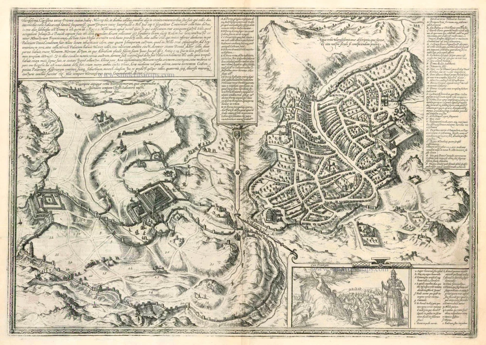
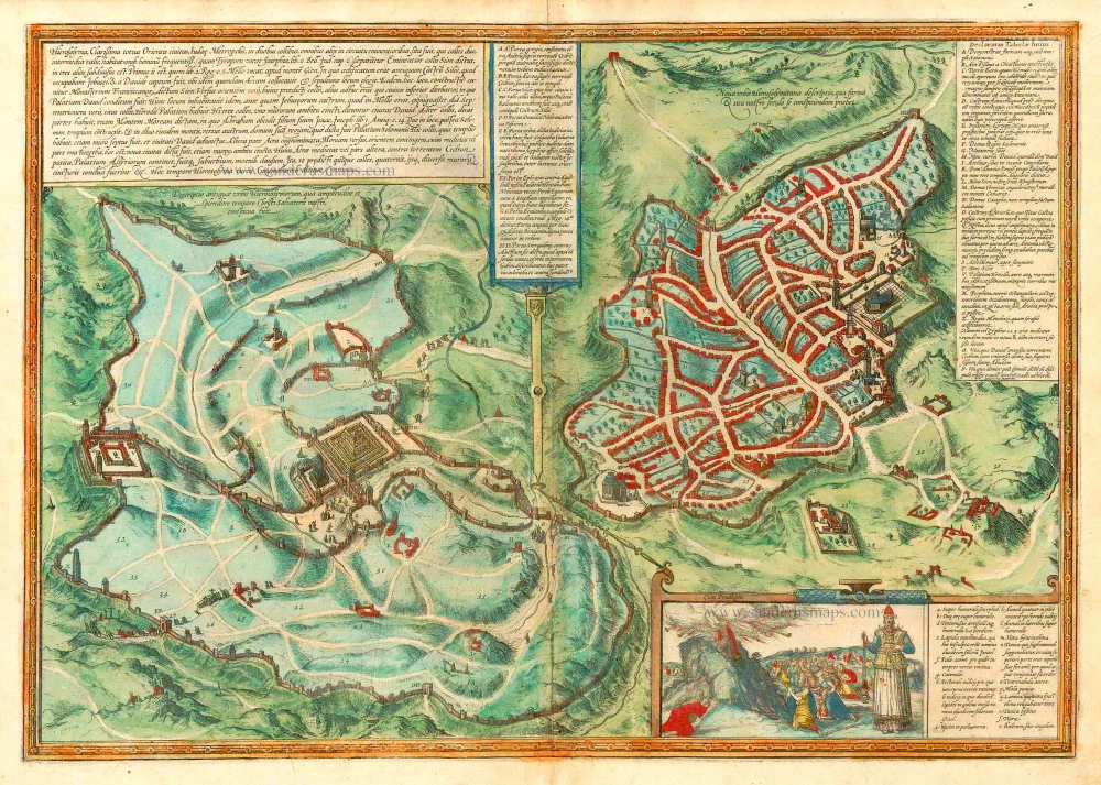
De Heylige en Wytvermaerde stad Ierusalem eerst genaemt Salem.
Item Number: 30536 Authenticity Guarantee
Category: Antique maps > Asia > Holy Land
Jerusalem by Nicolaes Visscher.
Title: De Heylige en Wytvermaerde stad Ierusalem eerst genaemt Salem.
CJVisscher Excud.
Oriented to the East.
Cartographer: C.J. Visscher.
Date of the first edition: 1657.
Date of this map: 1663.
Copper engraving, printed on paper.
Image size: 315 x 470mm (12.4 x 18.5 inches).
Sheet size: 450 x 510mm (17.72 x 20.08 inches).
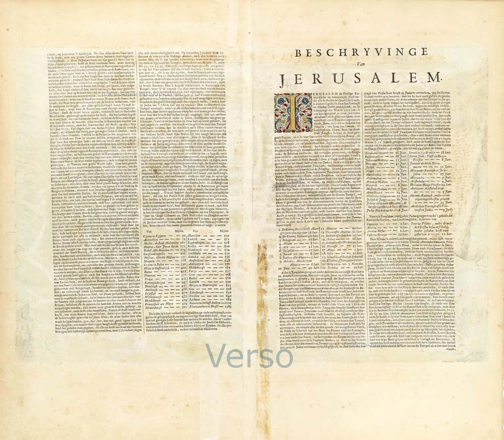
Verso: Dutch text.
Condition: Original coloured, heightened with god, lower centrefold split reinforced, tear lin lower margin closed.
Condition Rating: A.
From: Biblia, dat is, de gantsche Heylige Schriftue, vervattende alle de canonijcke boeken des Ouden en des Nieuwen Testaments. Leiden, J. Elzevier, 1663.
**********************
**********************
Jerusalem byNicolaas Visscher.
Title: De Heylige en Wytvermaerde stad Ierusalem eerst genaemt Salem.
CJVisscher Excud.
Oriented to the east.
Cartographer: C.J. Visscher.
Date of the first edition: 1657.
Date of this map: 1663.
Copper engraving, printed on paper.
Image size: 315 x 470mm (12.4 x 18.5 inches).
Sheet size: 450 x 510mm (17.72 x 20.08 inches).
Verso: Dutch text.
Condition: Original coloured, heightened with god, lower centrefold split reinforced, tear lin lower margin closed.
Condition Rating: A.
From: Biblia, dat is, de gantsche Heylige Schriftue, vervattende alle de canonijcke boeken des Ouden en des Nieuwen Testaments. Leiden, J. Elzevier, 1663.
The Visscher Family
For nearly a century, the members of the Visscher family were essential art dealers and map publishers in Amsterdam.
Claes Jansz. Visscher, or N.J. Piscator (1587-1652)
Claes Jansz. Vischer bought a house in Amsterdam, 'de gulden Bors', on the crucial Kalverstraat and changed the name into "In de Visscher"; under this title, the shop was to flourish for many years.
He was famous for his engravings and etchings of Dutch landscapes and 'historical scenes', such as sieges, battles, etc. These 'historical scenes' were considered contemporary illustrated news items, especially e.g. that of 'the Eighty Years' War'.
For the publication of his first atlas, he bought copperplates of the atlas Germania Inferior by Pieter van den Keere (1623).
In 1649, he published an atlas entitled Tabularum Geographicarum Contractarum, containing the same maps as Langenes' Caert Thresoor, for which Visscher had only new title pages engraved.
Claes Jansz. Visscher died in 1652. His wife, Neeltjen Florisdr., had already died in 1640. They had seven children, four of whom were still alive at Claes Jansz.'s death. One was Nicolaes Visscher I, who was to continue his father's business.
Nicolaes Visscher I (1618-1679)
Nicolaes Visscher I partnered with his father, continued the business, and stayed on the Kalverstraat 'in de Visscher' till his death.
In about 1657, the first edition of his Atlas Contractus Orbis Terrarum appeared.
Between 1664 and 1677, several editions of his Atlas Contractus appeared without a printed index, for these atlases had no fixed contents but were composed according to the buyer's financial leaping pole.
In May 1664, Nicolaes Visscher was admitted as a member of the Booksellers' Guild of his town. In July 1677, he was granted a patent of the States of Holland and West-Friesland for printing and publishing maps and atlases for 15 years.
After this, he again published an Atlas Contractus with a printed index. At about the same time, he also brought out an Atlas Minor.
Nicolaes Visscher II (1649-1702)
Nicolaes Visscher II inherited the 'shop' from his father. To obtain a new privilege, he applied to the States of Holland and West-Friesland in 1682 for a patent for printing and publishing maps. This patent was granted to him the same year. He moved the firm to the Dam, but it kept the same signboard: "In de Visscher".
Around 1683, he published his first Atlas Minor with a printed index of 91 maps. In 1684, an atlas Germania Inferior appeared. Till 1697, he published another number of atlases. He used his grandfather's (Claes Jansz.) maps less often now and relied more and more on his own.
The wars waged at this time initiated the compilation of maps of the countries where the armies operated. Many war maps were included in the various editions of his Atlas Minor.
After Nicolaes's death, his wife, Elizabeth Verseyl, published all the war maps as an atlas under the title De Stoel des Oorlogs in de Wereld (The seat of war in the world).
The widow of Nicolaes Visscher II (?-1726)
His widow continued the business energetically, and by her hand, under the name of her deceased husband, numerous atlases appeared, e.g., several editions of the Atlas Minor, an Atlas Maior and De Stoel des Oorlogs. The shop enjoyed a high reputation due to the assortment's incredible variety. Not only 'Visscher' maps but also maps of other publishers were obtainable. With the death of Elizabeth Verseyl in 1726, the last descendant died of a great map- and atlas-publishing firm in Amsterdam.
Related items
Hierosolyma, Clarissima Totius Orientis Civitas Iudaee Metropolis ... 1599
Jerusalem, by Georg Braun and Frans Hogenberg.
[Item number: 23948]
Hierosolyma, Clarissima Totius Orientis Civitas Iudaee Metropolis ... 1582
Jerusalem by Braun Georg & Hogenberg Frans
[Item number: 25330]
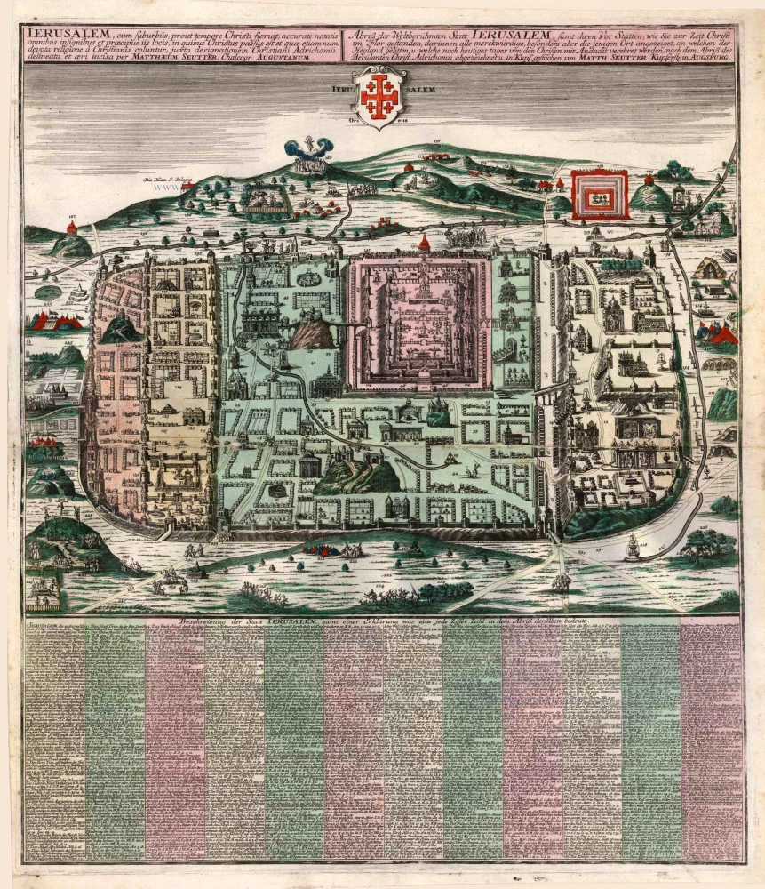
Ierusalem, cum Suburbiis, Prout Tempore Christi Floruit ... 1740
Jerusalem, by M. Seutter.
[Item number: 25345]
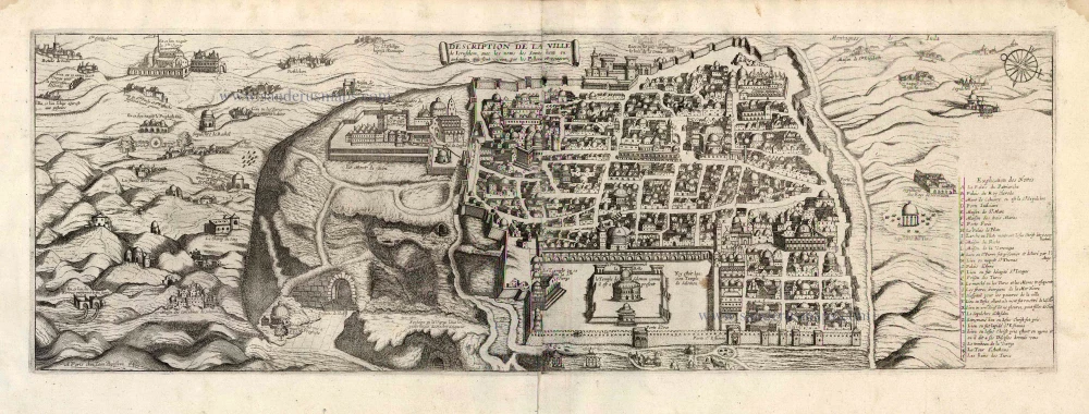
Description de la Ville de Jerusalem avec les Noms des Saints Lieux ou Antiquitez qui sont Visitez par les Pellerins et Voiageurs. 1648
Jerusalem by J. Boisseau.
[Item number: 25598]
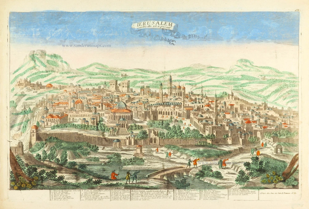
Ierusalem comme elle est a present. c. 1780
Jerusalem by Pierre Aveline.
[Item number: 28752]
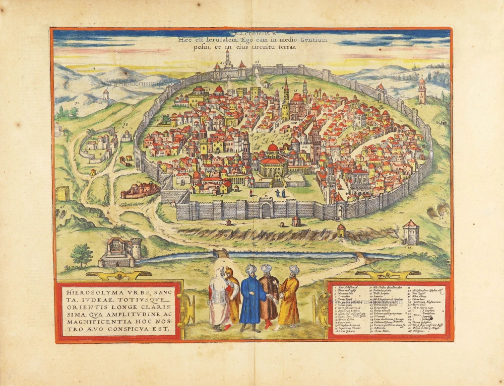
Hierosolyma Urbs Sancta, Iudeae, Totiusque Orientis Longe Clarissima ... 1623
Jerusalem, by Georg Braun & Frans Hogenberg
[Item number: 29229]
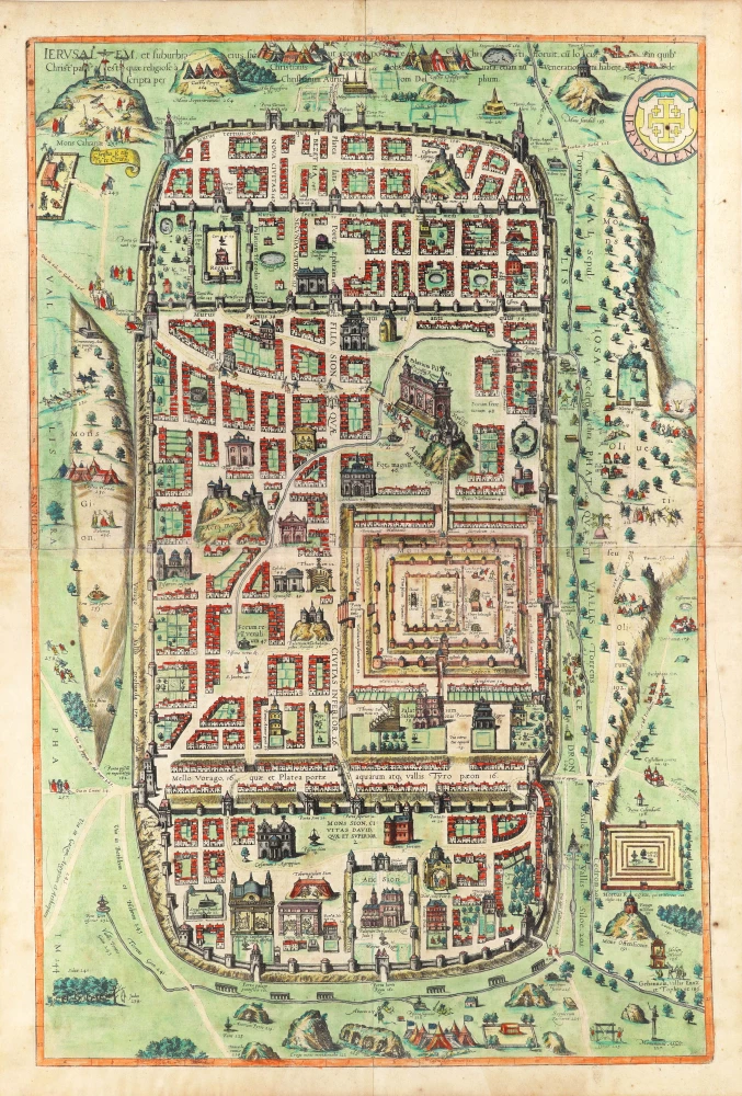
Ierusalem, et Suburbia eius, sicut Tempore Christi Floruit, cum Locis in quibus Christ Pass. est quae religiose à Christianis observata etiam num Veneratio ni habent descripta per Christianum Adrichom Delphum Delphum. 1617
Jerusalem by Georg Braun and Frans Hogenberg.
[Item number: 29850]
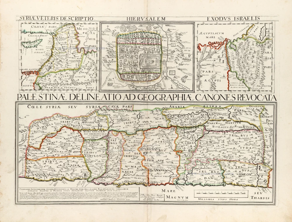
Palestinae Delineatio Ad Geographiae Canones Revocata. 1641
Holy Land - Jerusalem by Philippe Briet, published by Pierre Mariette.
[Item number: 30056]
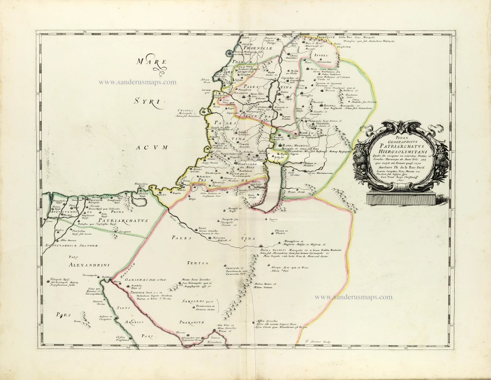
Pinax Geogpaphicus [sic] Patriarchatus Hierosolymitani [...] 1651
The Patriarchate of Jerusalem, by Philippe de la Rue, published by Pierre Mariette.
[Item number: 30120]