Southern India, by J.V. Bouchet. 1726
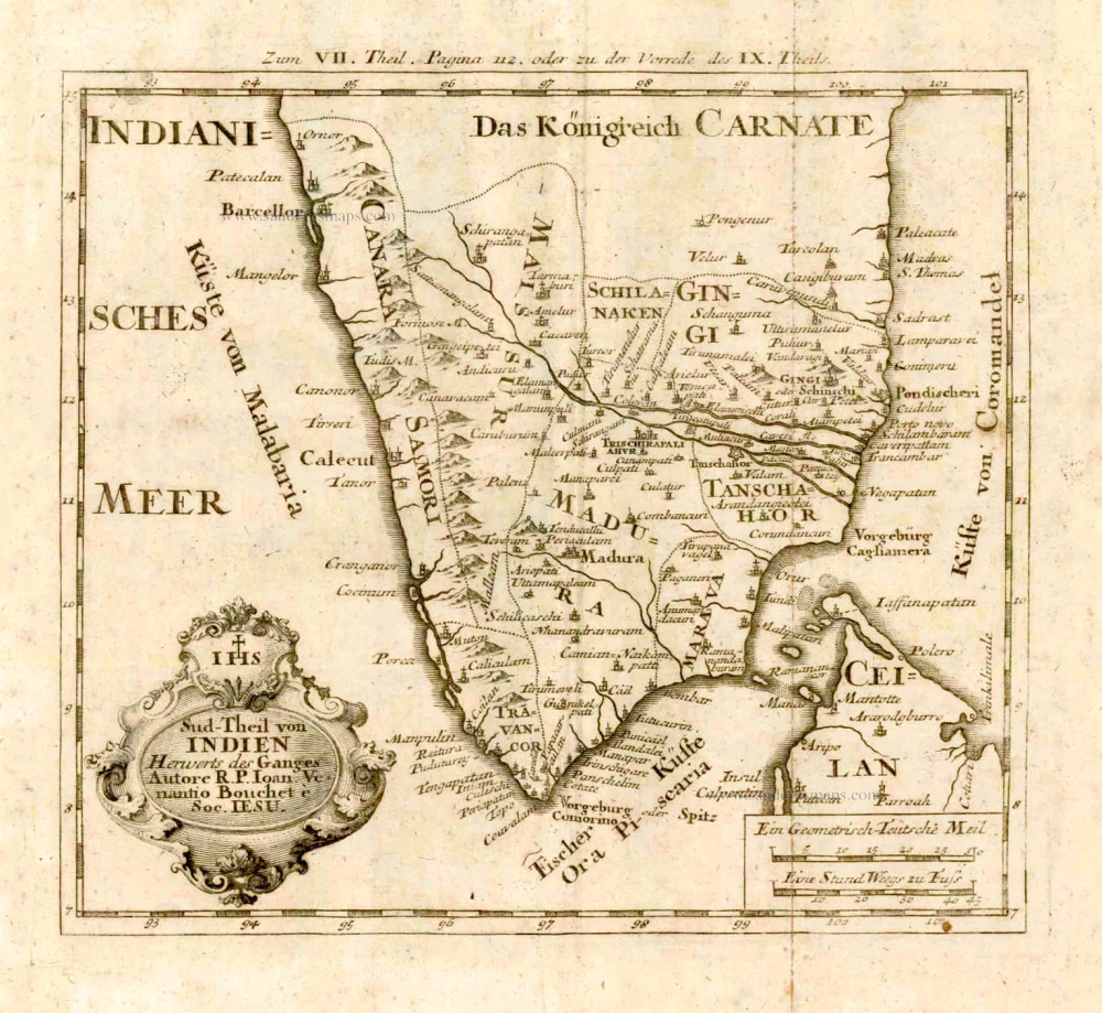
This is one of the earliest maps to accurately detail the interior of Southern India, depicting the subcontinent below the 16th degree of latitiude. Features are the great Indian states of the Nawabs of the Carnatic, Mysore, Madura, Tanjore, Cannara, Marava and Travancore. A legend at bottom left identifies "important locations," the residences of princes and governors, churches and temples. The French Jesuit Jean-Venant Bouchet (1655-1732) travelled with the French embassy to Siam in 1688, but the deteriorating political situation soon forced him to leave the for India. Over the next 30 years, Bouchet walked the countryside of Southern India, making careful surveys. In 1719, he dispatched his manuscript maps to France, which were recognized as revolutionary, as they contained the first accurate depiction of the interior of Southern India, especially the Deccan Plateau, within the mountains of the Eastern and Western Ghats.
Sud-Theil von Indien Herwerts des Ganges.
Item Number: 4184 Authenticity Guarantee
Category: Antique maps > Asia > India - Ceylon
Southern India, by J.V. Bouchet.
Title: Sud-Theil von Indien Herwerts des Ganges.
Autore R. P. Ioan. Venantio Bouchet e Soc. IESU.
Date: 1726.
Copper engraving, printed on paper.
Size (not including margins): 210 x 230mm (8.27 x 9.06 inches).
Verso: Blank.
Condition: Some light foxing.
Condition Rating: A.
From: Stöcklein J. Allerhand So Lehr- als Geistreiche Brief, Schriften und Reis-Beschreibungen, ... Augsburg, 1726.
This is one of the earliest maps to accurately detail the interior of Southern India, depicting the subcontinent below the 16th degree of latitiude. Features are the great Indian states of the Nawabs of the Carnatic, Mysore, Madura, Tanjore, Cannara, Marava and Travancore. A legend at bottom left identifies "important locations," the residences of princes and governors, churches and temples. The French Jesuit Jean-Venant Bouchet (1655-1732) travelled with the French embassy to Siam in 1688, but the deteriorating political situation soon forced him to leave the for India. Over the next 30 years, Bouchet walked the countryside of Southern India, making careful surveys. In 1719, he dispatched his manuscript maps to France, which were recognized as revolutionary, as they contained the first accurate depiction of the interior of Southern India, especially the Deccan Plateau, within the mountains of the Eastern and Western Ghats.

