
Ottoman Empire, by Guillaume Sanson, adapted by Giacomo Cantelli da Vignola, and published by Giovanni de Rossi. 1687
de Rossi Family
Seventeenth-century Rome was home to the famous publishing house of de Rossi. Two branches of the family used the addresses in Piazza Navona and Piazza della Pace; the latter was the more important house. Giuseppe de Rossi founded the house in 1613 and continued until he died in 1639. Giovanni Giacomo de Rossi flourished from 1649 to 1691. In 1677, he published a folio atlas titled Mercurio Geografico. It was drawn almost entirely from the cartography of the Sanson family in Paris. Whether it was with their permission or simple plagiarism is unknown, but they are credited. (Burden)
Giuseppe Rossi (flourished 1613-1639), Publisher at 'Piazza della Pace'.
Giovanni Giacomo de Rossi (1627-1691), Printer and publisher at 'Alla Pace all'insegna di Parigi', Rome.
Domenico de Rossi (flourished c. 1691-c. 1720), Successor to Giovanni Giacomo Rossi.
Lorenzo Filippo Rossi (flourished c. 1720-1738). Successor to Domenico.
In 1738, the Rossi plates were sold to the government of the Papal States.
SANSON FAMILY
Nicolas Sanson (1600-1667) - Guillaume Sanson (1633-1703) - Pierre Moullart-Sanson (? -1730)
Originally from Abbeville, Nicolas I Sanson showed a keen interest in historical geography. He was still very young; he published a map of ancient Gaul and two treatises, Britannia and Portus Itius on Abbeville and Boulogne's origins. His meeting with Melchior Tavernier was decisive: it prompted him to give up his duties as a military engineer in Picardy and devote himself to engraved cartography.
At the same time, Sanson had drawn up the outline of modern France. He got the help of Tavernier, who encouraged him to compete with the Dutch map publishers. Tavernier contacted other French cartographers whose works he published.
From 1643, N. Sanson obtained a privilege to publish a work personally, the Princes souverains de l'Italie. Then, in 1644 and 1645, he had his famous geographical tables printed, which significantly contributed to his fame. He also published a series of atlases in quarto of the four continents.
In 1648, N. Sanson associated himself with Mariette to publish atlases. From then on, specific maps bore his name and others Mariette's. N. Sanson and Mariette worked together for more than 20 years. After the death of N. Sanson, Mariette acquired the entire fund. Since Mariette only wanted to publish complete atlases, individual maps were no longer sold, and some army generals complained to the king.
The disagreement between the Sanson family and Pierre II Mariette culminated in 1671 when Guillaume Sanson took the case to court. There was no longer any question of collaboration: Guillaume Sanson started working for another publisher, Alexis-Hubert Jaillot.
The Sanson family faced financial difficulties, and in 1692, their cousin, Pierre Moullart-Sanson, bought the entire geographic fund from his uncles and aunt. Pierre Moullart-Sanson was the son of Françoise Sanson (third child of Nicolas) and Pierre Moullart. He restarted the publishing of Sanson's world atlas, and in 1704 he acquired a privilege for publishing all the works of Nicolas and Guillaume Sanson, which continued to be published until 1730.
Giacomo Cantelli da Vignola (1643-1695)
Italian cartographer and engraver. He was a geographer and court librarian to the Duke of Modena. Later, he moved to Venice, becoming well known as a geographer and cartographer. From 1672, his maps were published by Giovanni Giacomo de Rossi.
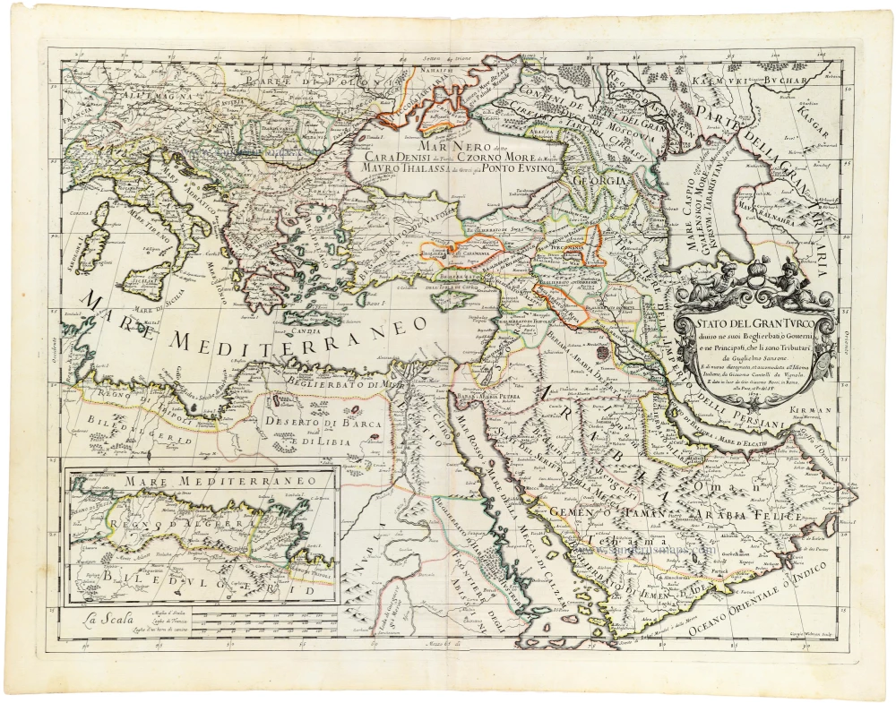
Stato del Gran Turco diviso ne suoi Beglierbau, ò Governi, e ne Principati, che li sono Tributari.
Item Number: 32955 Authenticity Guarantee
Category: Antique maps > Asia > Middle East
Ottoman Empire, by Guillaume Sanson, adapted by Giacomo Cantelli da Vignola, and published by Giovanni de Rossi.
Title: Stato del Gran Turco diviso ne suoi Beglierbau, ò Governi, e ne Principati, che li sono Tributari.
da Guglielmo Sansone,
E di nuovo dissegnata, et accomodata all'Idioma Italiano, da Giacomo Cantelli da Vignola
E data in luce da Gio. Giacomo Rossi, in Roma, alla Pace, c Pr. del S.P. 1679.
Giorgio Widman
With an inset map of the Barbary coast.
Engraver: Giorgio Widman.
Date of the first edition: 1679.
Date of this map: 1687.
Date on map: 1679.
Copper engraving, printed on paper.
Image size: 430 x 575mm (17 x 22¾ inches).
Sheet size: 480 x 620mm (19 x 24½ inches).
Verso: Blank.
Condition: Original coloured in outline, excellent.
Condition Rating: A+.
From: Mercurio Geografico overo Guida Geografica in Tutte le Parti di Mondo Conforme le Tavole Geografiche del Sansone Baudrand e Cantelli. Rome, [1687]. (Shirley (Brit. Lib.), T.ROSS-1b)
de Rossi Family
Seventeenth-century Rome was home to the famous publishing house of de Rossi. Two branches of the family used the addresses in Piazza Navona and Piazza della Pace; the latter was the more important house. Giuseppe de Rossi founded the house in 1613 and continued until he died in 1639. Giovanni Giacomo de Rossi flourished from 1649 to 1691. In 1677, he published a folio atlas titled Mercurio Geografico. It was drawn almost entirely from the cartography of the Sanson family in Paris. Whether it was with their permission or simple plagiarism is unknown, but they are credited. (Burden)
Giuseppe Rossi (flourished 1613-1639), Publisher at 'Piazza della Pace'.
Giovanni Giacomo de Rossi (1627-1691), Printer and publisher at 'Alla Pace all'insegna di Parigi', Rome.
Domenico de Rossi (flourished c. 1691-c. 1720), Successor to Giovanni Giacomo Rossi.
Lorenzo Filippo Rossi (flourished c. 1720-1738). Successor to Domenico.
In 1738, the Rossi plates were sold to the government of the Papal States.
SANSON FAMILY
Nicolas Sanson (1600-1667) - Guillaume Sanson (1633-1703) - Pierre Moullart-Sanson (? -1730)
Originally from Abbeville, Nicolas I Sanson showed a keen interest in historical geography. He was still very young; he published a map of ancient Gaul and two treatises, Britannia and Portus Itius on Abbeville and Boulogne's origins. His meeting with Melchior Tavernier was decisive: it prompted him to give up his duties as a military engineer in Picardy and devote himself to engraved cartography.
At the same time, Sanson had drawn up the outline of modern France. He got the help of Tavernier, who encouraged him to compete with the Dutch map publishers. Tavernier contacted other French cartographers whose works he published.
From 1643, N. Sanson obtained a privilege to publish a work personally, the Princes souverains de l'Italie. Then, in 1644 and 1645, he had his famous geographical tables printed, which significantly contributed to his fame. He also published a series of atlases in quarto of the four continents.
In 1648, N. Sanson associated himself with Mariette to publish atlases. From then on, specific maps bore his name and others Mariette's. N. Sanson and Mariette worked together for more than 20 years. After the death of N. Sanson, Mariette acquired the entire fund. Since Mariette only wanted to publish complete atlases, individual maps were no longer sold, and some army generals complained to the king.
The disagreement between the Sanson family and Pierre II Mariette culminated in 1671 when Guillaume Sanson took the case to court. There was no longer any question of collaboration: Guillaume Sanson started working for another publisher, Alexis-Hubert Jaillot.
The Sanson family faced financial difficulties, and in 1692, their cousin, Pierre Moullart-Sanson, bought the entire geographic fund from his uncles and aunt. Pierre Moullart-Sanson was the son of Françoise Sanson (third child of Nicolas) and Pierre Moullart. He restarted the publishing of Sanson's world atlas, and in 1704 he acquired a privilege for publishing all the works of Nicolas and Guillaume Sanson, which continued to be published until 1730.
Giacomo Cantelli da Vignola (1643-1695)
Italian cartographer and engraver. He was a geographer and court librarian to the Duke of Modena. Later, he moved to Venice, becoming well known as a geographer and cartographer. From 1672, his maps were published by Giovanni Giacomo de Rossi.
Related items

Turquie d'Europe. 1776-79
The Ottoman Empire, by Francesco Santini.
[Item number: 26972]

Imperium Turcicum in Europa, Asia et Africa, divisum in sua Regna et Regiones, nempe Graeciam, Natoliam, Armeniam, Arabiam, Aegyptum, Regna Algeriae, Tunetanum, Tripoleos et Barcae, cum reliquis adjacentibus regionibus. c. 1700
Ottoman Empire by Gerard and Leonard Valck.
[Item number: 28322]

Turcicum Imperium. ca. 1691-96
Ottoman Empire, by De Wit F.
[Item number: 28988]

Turcicum Imperium. 1652-53
Ottoman Empire by Henricus Hondius.
[Item number: 29168]

Danubii Fluvii Sive Turcici Imperii in Europa. c. 1705
Danube and European Ottoman Empire, by Frederick de Wit.
[Item number: 29279]

Carte de l'Empire Othoman considerée dans les Etats de cette Puissance, et des Etats qui l'avoisinent ou qui luy sont Tributaires, ainsi que deux petites Cartes pour conduire à l'Histoire Universelle, et en particulier à l'Histoire d'Alexandre le Grand, 1714
Ottoman Empire, by Zacharias Châtelain.
[Item number: 29399]

Estats de l'Empire du Grand Seigneur des Turqs ou Sultan des Ottomans en Asie, en Afrique, et en Europe. 1659
Ottoman Empire by Nicolas Sanson.
[Item number: 29713]

Estats de l'Empire du Grand Seigneur des Turcs en Europe, en Asie, et en Afrique ... 1692
Ottoman Empire by N. Sanson, so-called published by Hubert Jaillot. (Pirated edition by Pierre Mortier).
[Item number: 31198]

Turcicum Imperium. 1618
Ottoman Empire, by Petrus Bertius
[Item number: 32176]

Scarce
Accuratissima et Maxima Totius Turcici Imperii Tabula cum omnibus suis Regionibus. c. 1680
Ottoman Empire by Danckerts J.
[Item number: 32518]

Turcici Imperii Imago. 1628
Ottoman Empire, by Jodocus Hondius,
[Item number: 32688]

Turcici Imperii Descriptio. 1579
Ottoman Empire by Ortelius Abraham
[Item number: 32692]