
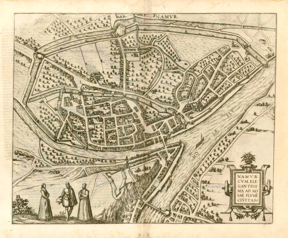
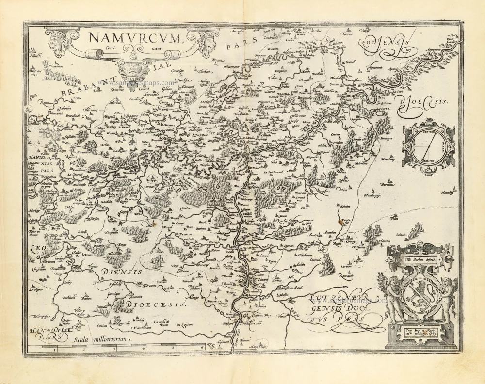
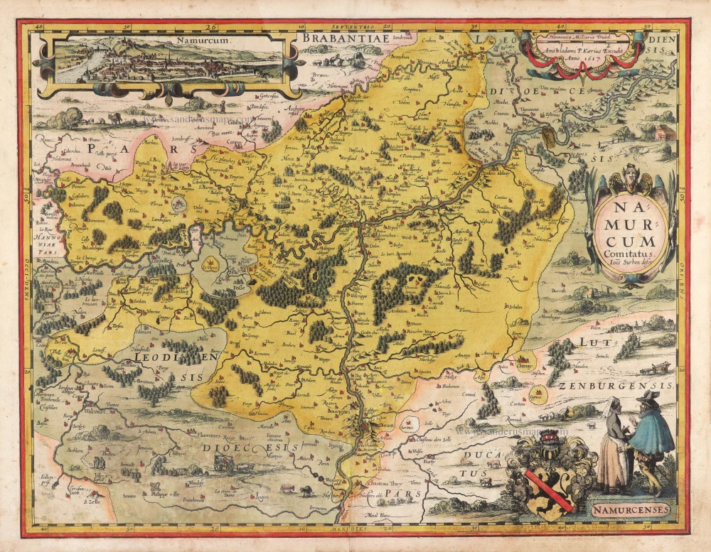
Namur, by Georg Braun & Frans Hogenberg. 1576
Braun G. & Hogenberg F. and the Civitates Orbis Terrarum.
The Civitates Orbis Terrarum, also known as the 'Braun & Hogenberg', is a six-volume town atlas and the most excellent book of town views and plans ever published: 363 engravings, sometimes beautifully coloured. It was one of the best-selling works in the last quarter of the 16th century. Georg Braun, a skilled writer, wrote the text accompanying the plans and views on the verso. Many plates were engraved after the original drawings of a professional artist, Joris Hoefnagel (1542-1600). The first volume was published in Latin in 1572 and the sixth in 1617. Frans Hogenberg, a talented engraver, created the tables for volumes I through IV, and Simon van den Neuwel made those for volumes V and VI. Other contributors were cartographers Daniel Freese and Heinrich Rantzau, who provided valuable geographical information. Works by Jacob van Deventer, Sebastian Münster, and Johannes Stumpf were also used as references. Translations appeared in German and French, making the atlas accessible to a broader audience.
Since its original publication of volume 1 in 1572, the Civitates Orbis Terrarum has left an indelible mark on the history of cartography. Seven more editions followed the first volume in 1575, 1577, 1582, 1588, 1593, 1599, and 1612. Vol.2, initially released in 1575, saw subsequent editions in 1597 and 1612. The subsequent volumes, each a treasure trove of historical insights, graced the world in 1581, 1588, 1593, 1599, and 1606. The German translation of the first volume, a testament to its widespread appeal, debuted in 1574, followed by the French edition in 1575.
Several printers were involved: Theodor Graminaeus, Heinrich von Aich, Gottfried von Kempen, Johannis Sinniger, Bertram Buchholtz, and Peter von Brachel, all of whom worked in Cologne.
Georg Braun (1541-1622)
Georg Braun, the author of the text accompanying the plans and views in the Civitates Orbis Terrarum, was born in Cologne in 1541. After his studies in Cologne, he entered the Jesuit Order as a novice, indicating his commitment to learning and intellectual pursuits. In 1561, he obtained his bachelor's degree; in 1562, he received his Magister Artium, further demonstrating his academic achievements. Although he left the Jesuit Order, he continued his studies in theology, gaining a licentiate in theology. His theological background likely influenced the content and tone of the text in the Civitates Orbis Terrarum, adding a unique perspective to the work.
Frans Hogenberg (1535-1590)
Frans Hogenberg was a Flemish and German painter, engraver, and mapmaker. He was born in Mechelen as the son of Nicolaas Hogenberg.
By the end of the 1560s, Frans Hogenberg was employed upon Abraham Ortelius's Theatrum Orbis Terrarum, published in 1570; he is named an engraver of numerous maps. In 1568, he was banned from Antwerp by the Duke of Alva and travelled to London, where he stayed a few years before emigrating to Cologne. He immediately embarked on his two most important works, the Civitates, published in 1572 and the Geschichtsblätter, which appeared in several series from 1569 until about 1587.
Thanks to large-scale projects like the Geschichtsblätter and the Civitates, Hogenberg's social circumstances improved with each passing year. He died as a wealthy man in Cologne in 1590.
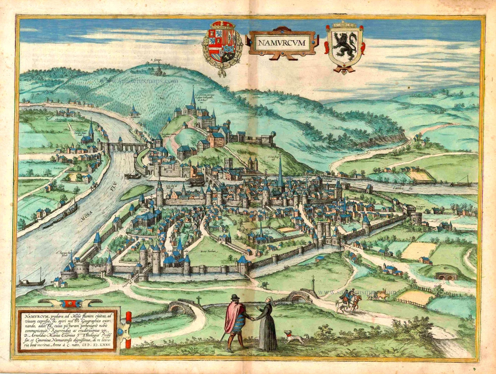
Namurcum, preclara ad Mosae flumen civitas, ...
Item Number: 26786 Authenticity Guarantee
Category: Antique maps > Europe > Belgium - Cities
Antique map - bird's-eye view of Namur, by Georg Braun and Frans Hogenberg.
Ancienne vue à vol d'oiseau de la ville de Namur, par Georg Braun and Frans Hogenberg.
TRANSLATION OF CARTOUCHE TEXT: Namur, famous city on the Meuse, drawn true to nature and included as an adornment in our geographical work, the plate of which was kindly provided by the reverend and most erudite gentlemand D. Arnoldus Masius, professor of Sacred Theology and venerable canon in Namur, of great academic merit. In the year 1575.
COMMENTARY BY BRAUN: "The County of Namur is a very mountainous province, but good for farming and very beautiful. In the mountains there is iron and also a very beautiful black, red and multi-coloured marble, but also another kind of stone, which is used for sculptures. The Meuse and the Sambre are two rivers that join together here and make this an important city. But Namur is also the name of the capital with its own bishopric."
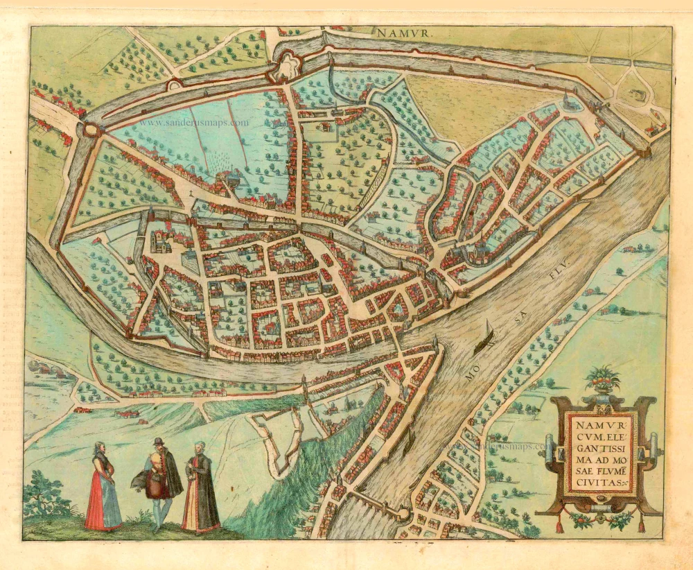
Namur is shown from the northeast as a low bird's-eye view, so that the castle that lies a little distance away on a hill over the Meuse appears in side view. The perspective allows the reader a good insight into the arrangement of the medieval town. In the middle of the town is the oldest church, the late Gothic parish church of Saint -Jean-Baptiste, with a high tower that is taller than all the other buildings in the town. The bell tower directly to the left of the parish church was replaced in the 18th century by the Tour Saint-Jacques. The Neoclassical cathedral of Saint-Aubin was also built in the 18th century, but includes the Gothic tower of a building that previously occupied the site, which can be seen to the right of the tower of Saint-Jean-Baptiste's church. (Taschen)
Date of the first edition: 1575
Date of this map: 1576
Date on map: 1575
Copper engraving, printed on paper.
Size (not including margins): 37 x 50cm (14.4 x 19.5 inches)
Verso text: German
Condition: Original coloured, slight browning along centrefold.
Condition Rating: A
References: Van der Krogt 4, 2947, State 1; Fauser, 9472; Taschen, Br. Hog., p. 153.
From: Beschreibung und Contrafactur von den vornembsten Stetten der Welt. Dass ander Buch. Köln, 1576. (Van der Krogt 4, 41:2.2)
Braun G. & Hogenberg F. and the Civitates Orbis Terrarum.
The Civitates Orbis Terrarum, also known as the 'Braun & Hogenberg', is a six-volume town atlas and the most excellent book of town views and plans ever published: 363 engravings, sometimes beautifully coloured. It was one of the best-selling works in the last quarter of the 16th century. Georg Braun, a skilled writer, wrote the text accompanying the plans and views on the verso. Many plates were engraved after the original drawings of a professional artist, Joris Hoefnagel (1542-1600). The first volume was published in Latin in 1572 and the sixth in 1617. Frans Hogenberg, a talented engraver, created the tables for volumes I through IV, and Simon van den Neuwel made those for volumes V and VI. Other contributors were cartographers Daniel Freese and Heinrich Rantzau, who provided valuable geographical information. Works by Jacob van Deventer, Sebastian Münster, and Johannes Stumpf were also used as references. Translations appeared in German and French, making the atlas accessible to a broader audience.
Since its original publication of volume 1 in 1572, the Civitates Orbis Terrarum has left an indelible mark on the history of cartography. Seven more editions followed the first volume in 1575, 1577, 1582, 1588, 1593, 1599, and 1612. Vol.2, initially released in 1575, saw subsequent editions in 1597 and 1612. The subsequent volumes, each a treasure trove of historical insights, graced the world in 1581, 1588, 1593, 1599, and 1606. The German translation of the first volume, a testament to its widespread appeal, debuted in 1574, followed by the French edition in 1575.
Several printers were involved: Theodor Graminaeus, Heinrich von Aich, Gottfried von Kempen, Johannis Sinniger, Bertram Buchholtz, and Peter von Brachel, all of whom worked in Cologne.
Georg Braun (1541-1622)
Georg Braun, the author of the text accompanying the plans and views in the Civitates Orbis Terrarum, was born in Cologne in 1541. After his studies in Cologne, he entered the Jesuit Order as a novice, indicating his commitment to learning and intellectual pursuits. In 1561, he obtained his bachelor's degree; in 1562, he received his Magister Artium, further demonstrating his academic achievements. Although he left the Jesuit Order, he continued his studies in theology, gaining a licentiate in theology. His theological background likely influenced the content and tone of the text in the Civitates Orbis Terrarum, adding a unique perspective to the work.
Frans Hogenberg (1535-1590)
Frans Hogenberg was a Flemish and German painter, engraver, and mapmaker. He was born in Mechelen as the son of Nicolaas Hogenberg.
By the end of the 1560s, Frans Hogenberg was employed upon Abraham Ortelius's Theatrum Orbis Terrarum, published in 1570; he is named an engraver of numerous maps. In 1568, he was banned from Antwerp by the Duke of Alva and travelled to London, where he stayed a few years before emigrating to Cologne. He immediately embarked on his two most important works, the Civitates, published in 1572 and the Geschichtsblätter, which appeared in several series from 1569 until about 1587.
Thanks to large-scale projects like the Geschichtsblätter and the Civitates, Hogenberg's social circumstances improved with each passing year. He died as a wealthy man in Cologne in 1590.
Related items
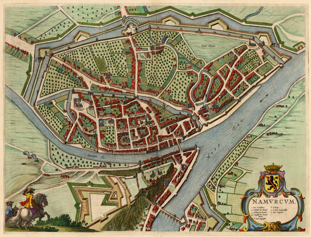
Namurcum, Elegantissima ad Mosae Flume Civitas. 1582
Namur, by Georg Braun and Frans Hogenberg.
[Item number: 14168]
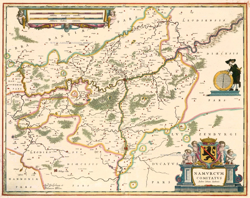
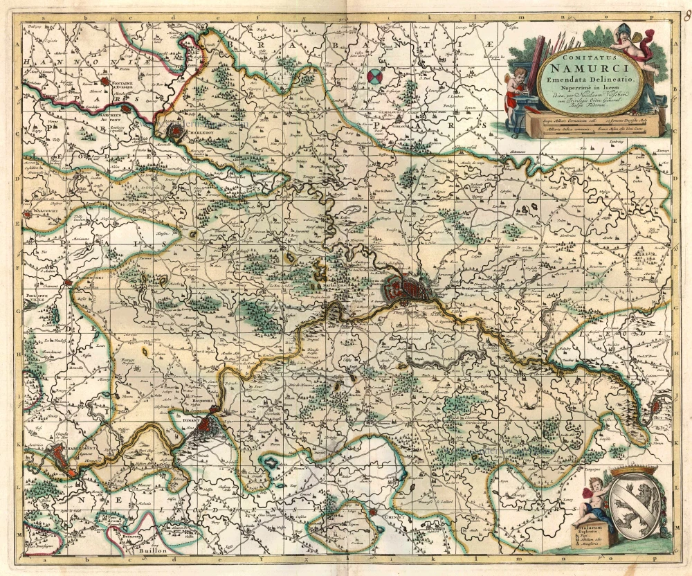
Namurcum Comitatus. 1659-72
Antique map of Namur by J. Blaeu
[Item number: 14785]
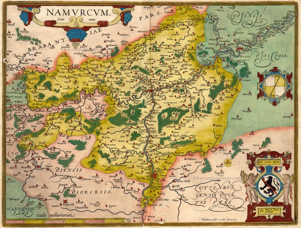
Namurcum Comitatus. Na 1612.
Namur, by Ortelius A. - Galle Th.
[Item number: 15490]
Namurcum 1649
Namur by Blaeu J.
[Item number: 18149]
Namurcum, Comitatus 1612
Namur by Abraham Ortelius.
[Item number: 22940]
Comitatus Namurci 1683-1696
Namur, by N. Visscher
[Item number: 24453]
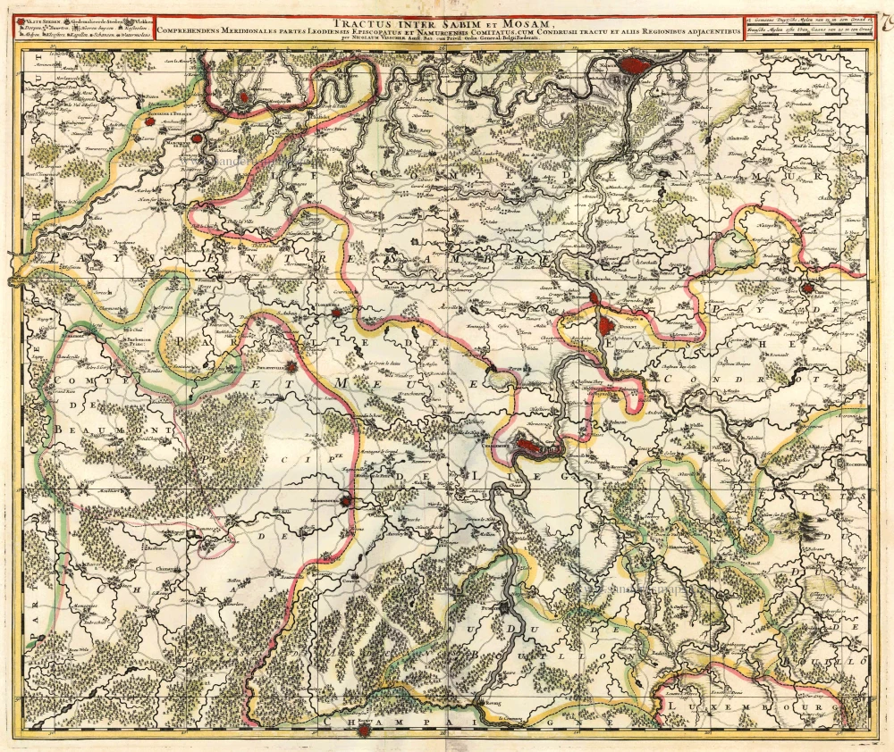
Tractus Inter Sabim Et Mosam 1683-1696
Namur by Visscher N. II.
[Item number: 24460]

Plan qui représente les Environs et la Circonvallation de Namur, du 4. Septembre au 6. Octobre. Avec les differentes positions de l'Armée du Roy et de celle des Alliés, depuis le 30. Juillet jusqu'au 19. Aoust 1746. Levé Geometriquement. 1746
Military manuscript map of the western vicinity of Namur.
[Item number: 24865]
Namurcum, Elegantissima ad Mosae Flume Civitas. 1581
Namur, by Georg Braun and Frans Hogenberg.
[Item number: 25415]
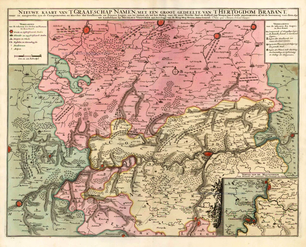
Nieuwe Kaart van 't Graafschap Namen, met een groot gedeelte van 't Hertogdom Brabant, ... 1720-30
Namur by N. Visscher II, published by P. Schenk.
[Item number: 25921]
Namurcum. 1617
Namur by Pieter Van den Keere (Petrus Kaerius).
[Item number: 30654]