
Namur by N. Visscher II, published by P. Schenk. 1720-30

The Visscher Family
For nearly a century, the members of the Visscher family were essential art dealers and map publishers in Amsterdam.
Claes Jansz. Visscher, or N.J. Piscator (1587-1652)
Claes Jansz. Vischer bought a house in Amsterdam, 'de gulden Bors', on the crucial Kalverstraat and changed the name into "In de Visscher"; under this title, the shop was to flourish for many years.
He was famous for his engravings and etchings of Dutch landscapes and 'historical scenes', such as sieges, battles, etc. These 'historical scenes' were considered contemporary illustrated news items, especially e.g. that of 'the Eighty Years' War'.
For the publication of his first atlas, he bought copperplates of the atlas Germania Inferior by Pieter van den Keere (1623).
In 1649, he published an atlas entitled Tabularum Geographicarum Contractarum, containing the same maps as Langenes' Caert Thresoor, for which Visscher had only new title pages engraved.
Claes Jansz. Visscher died in 1652. His wife, Neeltjen Florisdr., had already died in 1640. They had seven children, four of whom were still alive at Claes Jansz.'s death. One was Nicolaes Visscher I, who was to continue his father's business.
Nicolaes Visscher I (1618-1679)
Nicolaes Visscher I partnered with his father, continued the business, and stayed on the Kalverstraat 'in de Visscher' till his death.
In about 1657, the first edition of his Atlas Contractus Orbis Terrarum appeared.
Between 1664 and 1677, several editions of his Atlas Contractus appeared without a printed index, for these atlases had no fixed contents but were composed according to the buyer's financial leaping pole.
In May 1664, Nicolaes Visscher was admitted as a member of the Booksellers' Guild of his town. In July 1677, he was granted a patent of the States of Holland and West-Friesland for printing and publishing maps and atlases for 15 years.
After this, he again published an Atlas Contractus with a printed index. At about the same time, he also brought out an Atlas Minor.
Nicolaes Visscher II (1649-1702)
Nicolaes Visscher II inherited the 'shop' from his father. To obtain a new privilege, he applied to the States of Holland and West-Friesland in 1682 for a patent for printing and publishing maps. This patent was granted to him the same year. He moved the firm to the Dam, but it kept the same signboard: "In de Visscher".
Around 1683, he published his first Atlas Minor with a printed index of 91 maps. In 1684, an atlas Germania Inferior appeared. Till 1697, he published another number of atlases. He used his grandfather's (Claes Jansz.) maps less often now and relied more and more on his own.
The wars waged at this time initiated the compilation of maps of the countries where the armies operated. Many war maps were included in the various editions of his Atlas Minor.
After Nicolaes's death, his wife, Elizabeth Verseyl, published all the war maps as an atlas under the title De Stoel des Oorlogs in de Wereld (The seat of war in the world).
The widow of Nicolaes Visscher II (?-1726)
His widow continued the business energetically, and by her hand, under the name of her deceased husband, numerous atlases appeared, e.g., several editions of the Atlas Minor, an Atlas Maior and De Stoel des Oorlogs. The shop enjoyed a high reputation due to the assortment's incredible variety. Not only 'Visscher' maps but also maps of other publishers were obtainable. With the death of Elizabeth Verseyl in 1726, the last descendant died of a great map- and atlas-publishing firm in Amsterdam.
The Schenk Family
Petrus Schenk (1660-1718), the founder of one of the best-known publishing firms of Amsterdam in the 18th century, was born in Elberfeld, Germany, in 1660. He went to Amsterdam, where he became a pupil of the engraver Gerard Valck. On 19 Nov. 1686, a privilegio was granted to Petrus Schenk and Gerard Valk for the manufacturing and selling their prints—Schenk’s contribution to cartography dates from c. 1695. In 1706, he moved to the Vijgendam in Amsterdam, ‘in Sanson’s Atlas’. After he died in 1718, his son, Leonardus Schenk, continued the art and print shop. The second son, Petrus II (1693-1775), settled in another famous house: ‘in Visscher’s Atlas’, where he continued associating with Gerard and Leonarus Valck.
The Schenk family produced general geographical atlases and special atlases. Apart from seventy original maps, several hundred are known as Schenk, printed from plates obtained from Janssonius and Visscher. Schenk and Valck acquired all the plates of the Janssonius Heir’s Novus Atlas, including the Celestial Atlas. Many of Janssonius’ plates were reworked and amended.
Republishing maps from Janssonius’ Novus Atlas since c. 1680 was followed by engraving new maps copied from Sanson’s better and more modern maps. Petrus Schenk published these maps in his Atlas Contractus sive mapparum geographicarum Sansoniarum auctarum et correctum Nova Congeries, also called Atlas Minor. After 1719, Petrus Schenk II continued the Atlas Contractus.
Petrus Schenk, the elder, enjoyed great fame as a print seller and artist among art and print dealers in the whole of Europe. The great activity in map publishing, displayed by Petrus Schenk, the elder, was continued by his son and grandson. But the number of original atlas maps is small. Like his father, who bought the copperplates of Janssonius’ atlas, Petrus Schenk II bought many of the plates formerly owned by Nicolaas Visscher.
Apart from the globes, maps and atlases, Petrus Schenk II published many books. In 1733, he was older men of the booksellers guild in 1733.
Petrus Schenk Junior (1728-1803) was an engraver and artseller. He continued to publish many of the titles his father and grandfather issued, and the globes of his uncle Leonard Valk.
Nieuwe Kaart van 't Graafschap Namen, met een groot gedeelte van 't Hertogdom Brabant, ...
Item Number: 25921 Authenticity Guarantee
Category: Antique maps > Europe > Belgium
Old, antique map of the Duchy of Namur by N. Visscher II, published by P. Schenk.
With inset showing the vicinity of Dinant - Charlemont.
Copper engraving, printed on paper.
Size (not including margins): 48 x 61cm (18.7 x 23.8 inches)
Verso: Blank
Condition: Original coloured, excellent.
Condition Rating: A+
From: Atlas Contractus sive Mapparum Geographicarum Sansoniarum auctarum et correctarum Nova Congeries. Amsterdam, P. Schenk, c. 1720-30. (Koeman, Sche 1)
The Visscher Family
For nearly a century, the members of the Visscher family were essential art dealers and map publishers in Amsterdam.
Claes Jansz. Visscher, or N.J. Piscator (1587-1652)
Claes Jansz. Vischer bought a house in Amsterdam, 'de gulden Bors', on the crucial Kalverstraat and changed the name into "In de Visscher"; under this title, the shop was to flourish for many years.
He was famous for his engravings and etchings of Dutch landscapes and 'historical scenes', such as sieges, battles, etc. These 'historical scenes' were considered contemporary illustrated news items, especially e.g. that of 'the Eighty Years' War'.
For the publication of his first atlas, he bought copperplates of the atlas Germania Inferior by Pieter van den Keere (1623).
In 1649, he published an atlas entitled Tabularum Geographicarum Contractarum, containing the same maps as Langenes' Caert Thresoor, for which Visscher had only new title pages engraved.
Claes Jansz. Visscher died in 1652. His wife, Neeltjen Florisdr., had already died in 1640. They had seven children, four of whom were still alive at Claes Jansz.'s death. One was Nicolaes Visscher I, who was to continue his father's business.
Nicolaes Visscher I (1618-1679)
Nicolaes Visscher I partnered with his father, continued the business, and stayed on the Kalverstraat 'in de Visscher' till his death.
In about 1657, the first edition of his Atlas Contractus Orbis Terrarum appeared.
Between 1664 and 1677, several editions of his Atlas Contractus appeared without a printed index, for these atlases had no fixed contents but were composed according to the buyer's financial leaping pole.
In May 1664, Nicolaes Visscher was admitted as a member of the Booksellers' Guild of his town. In July 1677, he was granted a patent of the States of Holland and West-Friesland for printing and publishing maps and atlases for 15 years.
After this, he again published an Atlas Contractus with a printed index. At about the same time, he also brought out an Atlas Minor.
Nicolaes Visscher II (1649-1702)
Nicolaes Visscher II inherited the 'shop' from his father. To obtain a new privilege, he applied to the States of Holland and West-Friesland in 1682 for a patent for printing and publishing maps. This patent was granted to him the same year. He moved the firm to the Dam, but it kept the same signboard: "In de Visscher".
Around 1683, he published his first Atlas Minor with a printed index of 91 maps. In 1684, an atlas Germania Inferior appeared. Till 1697, he published another number of atlases. He used his grandfather's (Claes Jansz.) maps less often now and relied more and more on his own.
The wars waged at this time initiated the compilation of maps of the countries where the armies operated. Many war maps were included in the various editions of his Atlas Minor.
After Nicolaes's death, his wife, Elizabeth Verseyl, published all the war maps as an atlas under the title De Stoel des Oorlogs in de Wereld (The seat of war in the world).
The widow of Nicolaes Visscher II (?-1726)
His widow continued the business energetically, and by her hand, under the name of her deceased husband, numerous atlases appeared, e.g., several editions of the Atlas Minor, an Atlas Maior and De Stoel des Oorlogs. The shop enjoyed a high reputation due to the assortment's incredible variety. Not only 'Visscher' maps but also maps of other publishers were obtainable. With the death of Elizabeth Verseyl in 1726, the last descendant died of a great map- and atlas-publishing firm in Amsterdam.
The Schenk Family
Petrus Schenk (1660-1718), the founder of one of the best-known publishing firms of Amsterdam in the 18th century, was born in Elberfeld, Germany, in 1660. He went to Amsterdam, where he became a pupil of the engraver Gerard Valck. On 19 Nov. 1686, a privilegio was granted to Petrus Schenk and Gerard Valk for the manufacturing and selling their prints—Schenk’s contribution to cartography dates from c. 1695. In 1706, he moved to the Vijgendam in Amsterdam, ‘in Sanson’s Atlas’. After he died in 1718, his son, Leonardus Schenk, continued the art and print shop. The second son, Petrus II (1693-1775), settled in another famous house: ‘in Visscher’s Atlas’, where he continued associating with Gerard and Leonarus Valck.
The Schenk family produced general geographical atlases and special atlases. Apart from seventy original maps, several hundred are known as Schenk, printed from plates obtained from Janssonius and Visscher. Schenk and Valck acquired all the plates of the Janssonius Heir’s Novus Atlas, including the Celestial Atlas. Many of Janssonius’ plates were reworked and amended.
Republishing maps from Janssonius’ Novus Atlas since c. 1680 was followed by engraving new maps copied from Sanson’s better and more modern maps. Petrus Schenk published these maps in his Atlas Contractus sive mapparum geographicarum Sansoniarum auctarum et correctum Nova Congeries, also called Atlas Minor. After 1719, Petrus Schenk II continued the Atlas Contractus.
Petrus Schenk, the elder, enjoyed great fame as a print seller and artist among art and print dealers in the whole of Europe. The great activity in map publishing, displayed by Petrus Schenk, the elder, was continued by his son and grandson. But the number of original atlas maps is small. Like his father, who bought the copperplates of Janssonius’ atlas, Petrus Schenk II bought many of the plates formerly owned by Nicolaas Visscher.
Apart from the globes, maps and atlases, Petrus Schenk II published many books. In 1733, he was older men of the booksellers guild in 1733.
Petrus Schenk Junior (1728-1803) was an engraver and artseller. He continued to publish many of the titles his father and grandfather issued, and the globes of his uncle Leonard Valk.
Related items

Hannonia Namurcum Comitatus. 1619
Hainaut - Namur, by G. Mercator
[Item number: 12182]
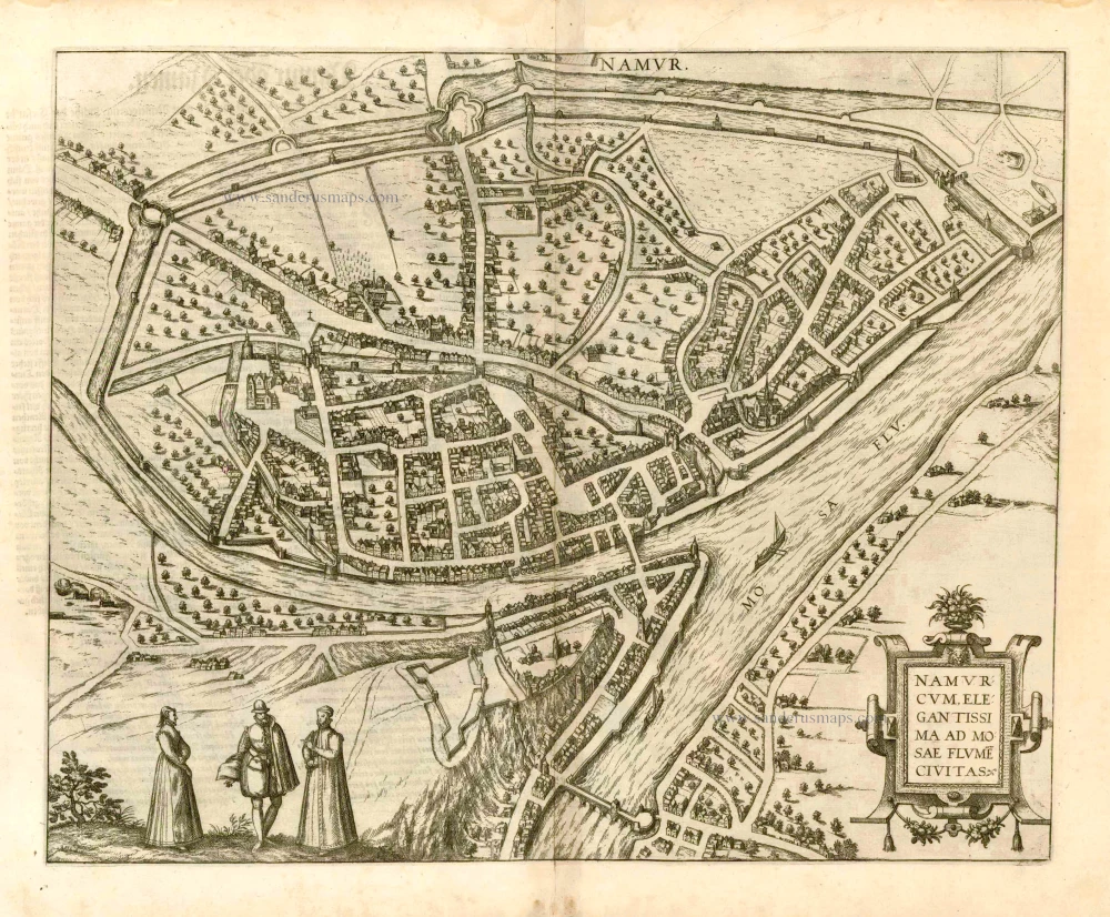
Namurcum, Elegantissima ad Mosae Flume Civitas. 1582
Namur, by Georg Braun and Frans Hogenberg.
[Item number: 14168]

Namurcum Comitatus. 1659-72
Antique map of Namur by J. Blaeu
[Item number: 14785]

Namurcum Comitatus. Na 1612.
Namur, by Ortelius A. - Galle Th.
[Item number: 15490]
Namurcum 1649
Namur by Blaeu J.
[Item number: 18149]

Namurcum, Comitatus 1612
Namur by Abraham Ortelius.
[Item number: 22940]

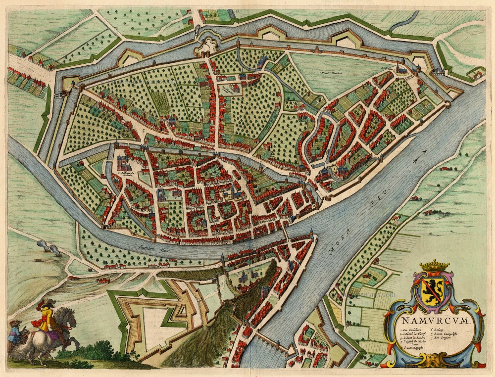
Comitatus Namurci 1683-1696
Namur, by N. Visscher
[Item number: 24453]

Tractus Inter Sabim Et Mosam 1683-1696
Namur by Visscher N. II.
[Item number: 24460]

Plan qui représente les Environs et la Circonvallation de Namur, du 4. Septembre au 6. Octobre. Avec les differentes positions de l'Armée du Roy et de celle des Alliés, depuis le 30. Juillet jusqu'au 19. Aoust 1746. Levé Geometriquement. 1746
Military manuscript map of the western vicinity of Namur.
[Item number: 24865]

Plan des Attaques des villes, ports et Chateaux de Namur, 1746. [Title from label on the back.] 1746
Namur, military manuscript map
[Item number: 24870]

Hannonia. Namurcum Comitatus 1623
Hainaut and Namur, by G. Mercator.
[Item number: 24919]

Namurcum, Elegantissima ad Mosae Flume Civitas. 1581
Namur, by Georg Braun and Frans Hogenberg.
[Item number: 25415]

Namurcum, preclara ad Mosae flumen civitas, ... 1576
Namur, by Georg Braun & Frans Hogenberg.
[Item number: 26786]

Namurcum. 1617
Namur by Pieter Van den Keere (Petrus Kaerius).
[Item number: 30654]
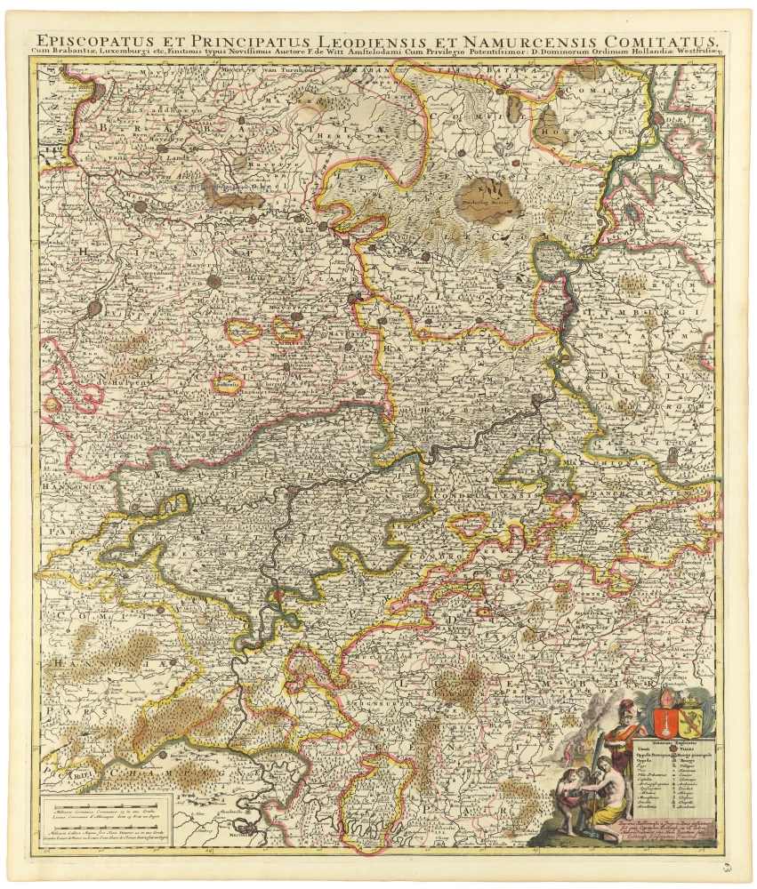
Episcopatus et Principatus Leodiensis et Namurcensis Comitatus, Cum Brabantiae, Luxemburgi etc. c. 1705-06
Liège - Namur, by Frederick de Wit.
[Item number: 33158]