
France, by François de Belleforest. 1575

The Cosmographie Universelle of F. de Belleforest was published in a shared edition by Nicolas Chesneau and Michel Sonnius. The objective of the two partners was to reprint Sébastien Münster's Cosmographie in French. Münster's work, published in Basel in 1544, had indeed been a great success and had known multiple reissues. It had been published in French in 1552, but Chesneau and Sonnius, noting that Münster had mainly treated his own country, Germany, wanted to satisfy the tastes of their compatriots more.
They appealed for the text of the work to François de Belleforest (1530-1583). Belleforest probably helped Chesneau and Sonnius in their quest for new city plans.
Belleforest's Cosmographie is presented in two parts, the first of which is divided into two volumes; each of the three volumes has its own title. Some copies bear the imprint of Chesneau and others that of Sonnius.
Of the 163 plates in the Cosmographie, only 49 are copied from the work of Sebastian Münster. Little is known about the engravers of the Cosmographie. The name of Cruche appears only once, at the bottom of the plate of Paris. Raymont Rancurel is the second known engraver in the Cosmographie. In 1572 appeared, the first volume of the Civitates Orbis Terrarum of Braun and Hogenberg. Twenty of these plates were copied by the Cosmographie of Belleforest. On the other hand, the later volumes of the Civitates borrowed eleven cities from Belleforest's work. From the Theatrum Orbis Terrarum of Abraham Ortelius (1570), Chesneau and Sonnius have retained more modern maps than those of Münster. Other plans have been copied from the Plantz and Pourtraitz by Antoine Du Pinet or from the small maps of Camocio.
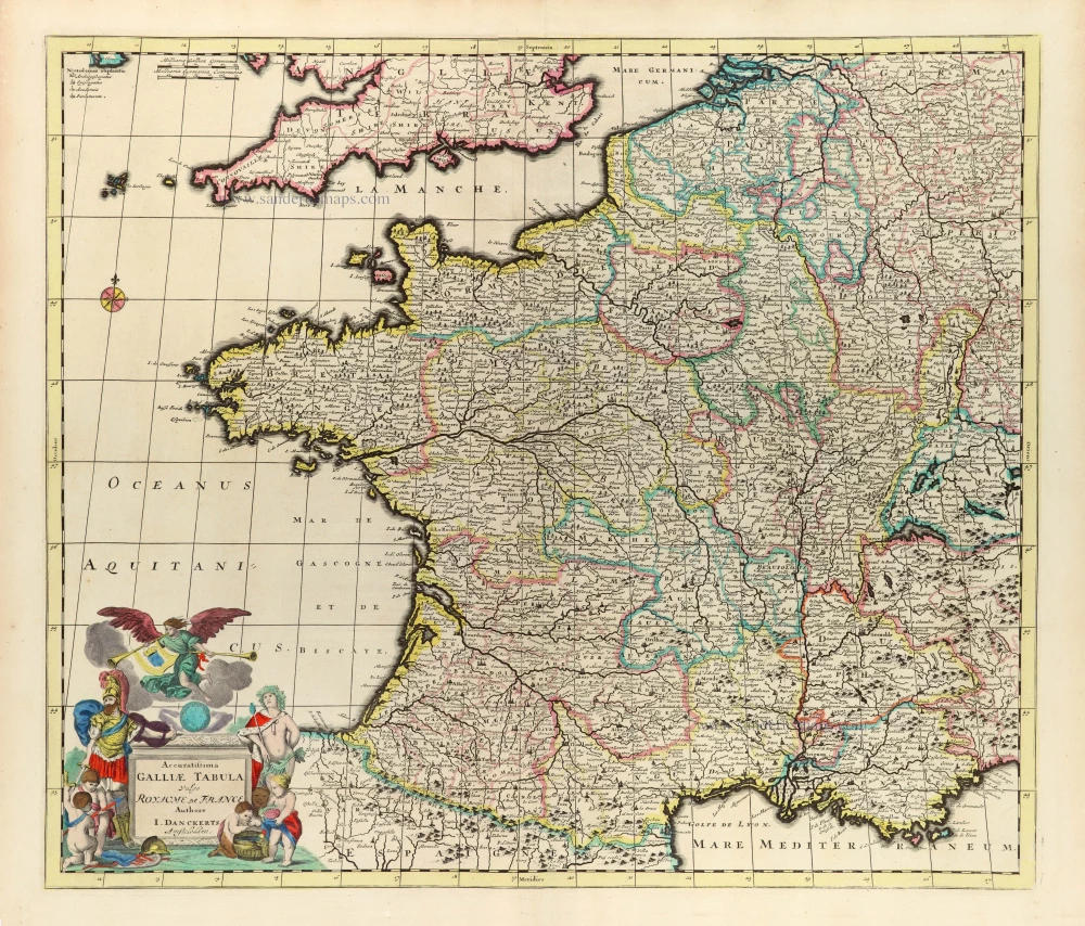
Description Générale de Toute la France.
Item Number: 27166 Authenticity Guarantee
Category: Antique maps > Europe > France
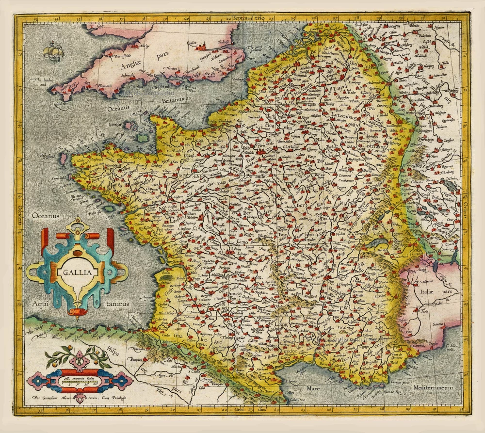
Old, antique map of France, by François de Belleforest.
Carte ancienne de la France, par François de Belleforest.
Date de la première édition: 1575
Date de cette carte: 1575
Gravure sur bois, imprimée sur papier.
Dimensions (hors marges): 34 x 50cm
Verso: Vierge
État: Excellent.
Évaluation de l'état: A+
Références: Pastoureau, Belleforest I-1 [8]
Origine: La Cosmographie Universelle de tout le Monde. Paris, Nicolas Chesneau - Michel Sonnius, 1575. (= French edition of Münster's Cosmographia).
D'après Abraham Ortelius.
The Cosmographie Universelle of F. de Belleforest was published in a shared edition by Nicolas Chesneau and Michel Sonnius. The objective of the two partners was to reprint Sébastien Münster's Cosmographie in French. Münster's work, published in Basel in 1544, had indeed been a great success and had known multiple reissues. It had been published in French in 1552, but Chesneau and Sonnius, noting that Münster had mainly treated his own country, Germany, wanted to satisfy the tastes of their compatriots more.
They appealed for the text of the work to François de Belleforest (1530-1583). Belleforest probably helped Chesneau and Sonnius in their quest for new city plans.
Belleforest's Cosmographie is presented in two parts, the first of which is divided into two volumes; each of the three volumes has its own title. Some copies bear the imprint of Chesneau and others that of Sonnius.
Of the 163 plates in the Cosmographie, only 49 are copied from the work of Sebastian Münster. Little is known about the engravers of the Cosmographie. The name of Cruche appears only once, at the bottom of the plate of Paris. Raymont Rancurel is the second known engraver in the Cosmographie. In 1572 appeared, the first volume of the Civitates Orbis Terrarum of Braun and Hogenberg. Twenty of these plates were copied by the Cosmographie of Belleforest. On the other hand, the later volumes of the Civitates borrowed eleven cities from Belleforest's work. From the Theatrum Orbis Terrarum of Abraham Ortelius (1570), Chesneau and Sonnius have retained more modern maps than those of Münster. Other plans have been copied from the Plantz and Pourtraitz by Antoine Du Pinet or from the small maps of Camocio.
Related items
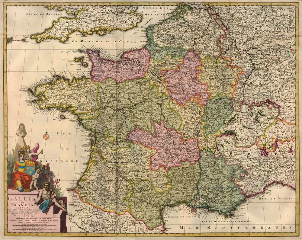
Galliae seu Franciae Tabula, ... 1683-1696
France, by Visscher N. II.
[Item number: 15637]
Gallia / Per Gerardum Mercatorem. 1609
France, by Gerard Mercator.
[Item number: 19119]

Galliae Veteris Typus. 1652-53
Ancient France by Joannes Janssonius.
[Item number: 20936]

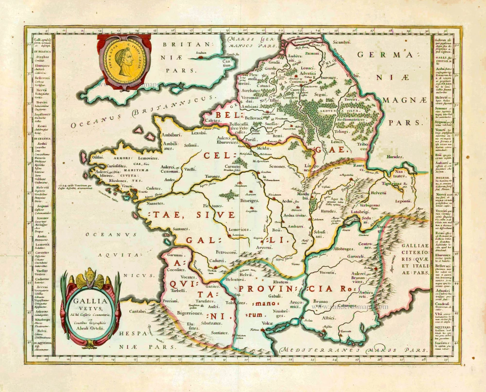
Galliae Veteris. 1601
France, by Ortelius A.
[Item number: 21253]

[No title] 1607
France, by Jodocus Hondius.
[Item number: 25294]

Rare!
Galliae Amplissimi Regni Tabula. 1593
France, by Gerard de Jode.
[Item number: 26035]
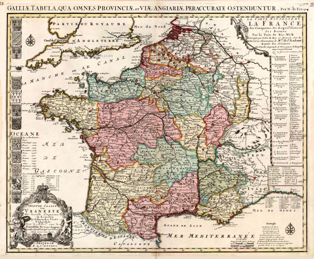
Nieuwe Caarte van Vrankryk Met desselfs Conquesten en Limiten by de Ryswykse Vrede Vastgestelt, ... 1730-45
France, by R. & I. Ottens.
[Item number: 26251]
Gallia Vetus. 1640
Ancient France, by Willem Blaeu.
[Item number: 27153]
Description Générale de Toute la France. 1575
France, by François de Belleforest.
[Item number: 27166]

Gallia. 1619
France, by Jodocus Hondius.
[Item number: 28840]

Galliae Antiquae Descriptio Geograpfica. 1659
Ancient France by Nicolas Sanson, published by Melchior Tavernier
[Item number: 30031]

Le Royaume de France et ses Acquisitions vers les Pays Bas, l'Allemagne, l'Italie et l'Espagne. 1665
France by Nicolas Sanson.
[Item number: 30082]

Galliae Veteris. 1624
Ancient France, by Ortelius A.
[Item number: 31191]

Gallia - Nova totius Galliae geographica descriptio, ... Ineaque archiepiscopatus, episcopatus omnes, academiae item et parlamenta singula suis quaequae notis distincta a Iuodoco Hondio. c. 1610-1650
France by Jodocus Hondius, published by Melchior Tavernier.
[Item number: 31308]

Galliae Veteris Typus. c. 1610-1650
Ancient France by Jodocus Hondius
[Item number: 31312]
Gallia - Le Royaume de France. 1642-43
France, by Willem Blaeu.
[Item number: 32434]
Scarce
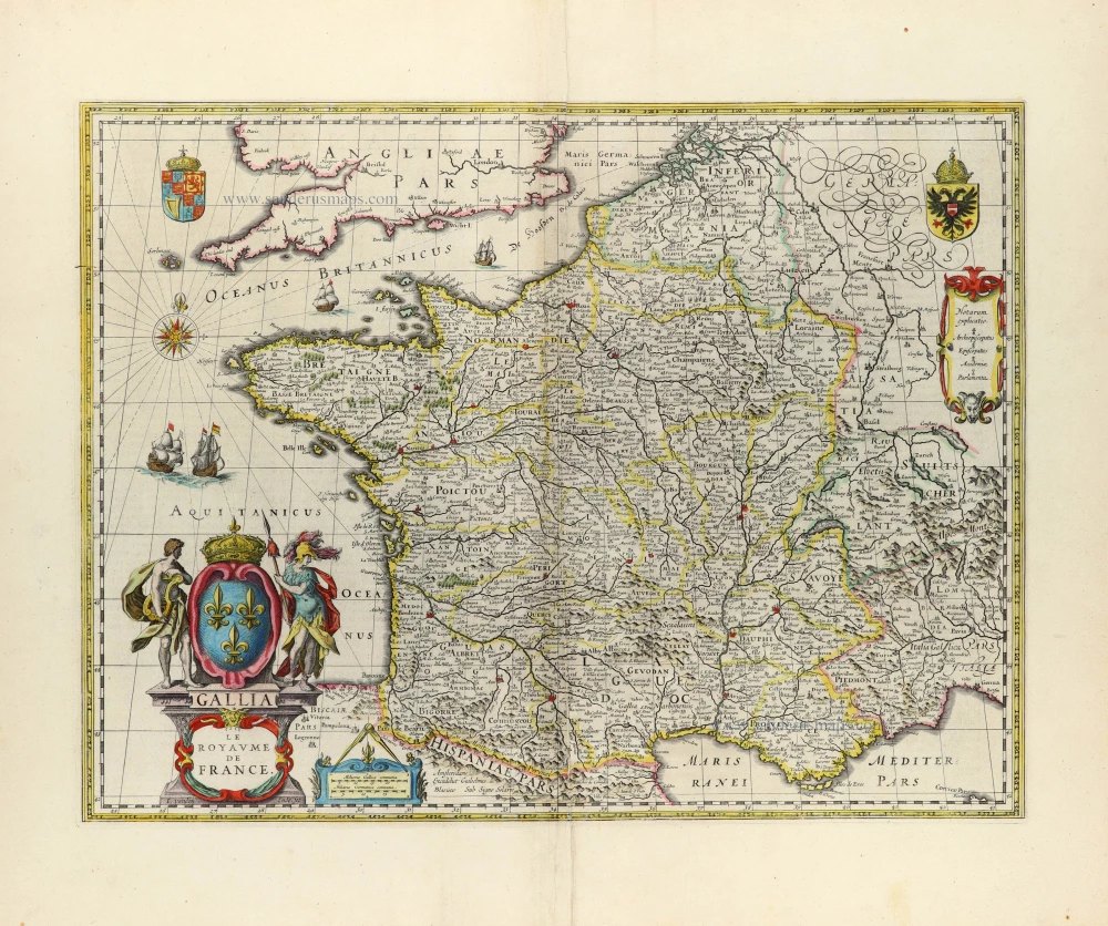
Accuratissima Galliae Tabula Vulgo Royaume de France. c. 1680
France by Justus Danckerts
[Item number: 32463]