
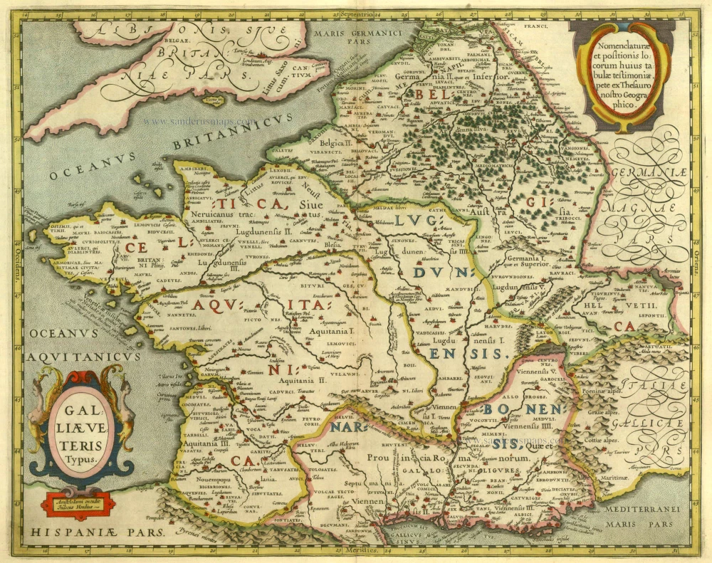
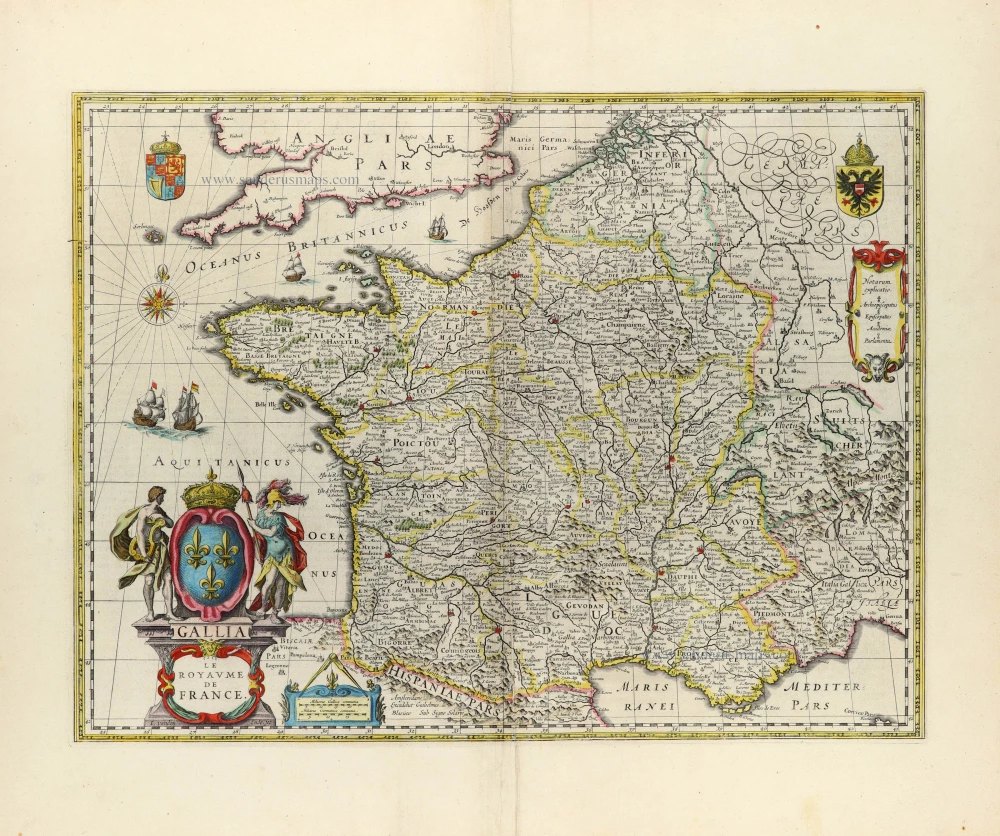
Ancient France by Joannes Janssonius. 1652-53

The Janssonius Family
Joannes Janssonius (Arnhem, 1588-1664), son of the Arnhem publisher Jan Janssen, married Elisabeth Hondius, daughter of Jodocus Hondius, in Amsterdam in 1612. After his marriage, he settled down in this town as a bookseller and publisher of cartographic material. In 1618, he established himself in Amsterdam next door to Blaeu’s bookshop. He entered into serious competition with Willem Jansz. Blaeu when copying Blaeu’s Licht der Zeevaert after the expiration of the privilege in 1620. His activities concerned the publication of atlases, books, single maps, and an extensive book trade with branches in Frankfurt, Danzig, Stockholm, Copenhagen, Berlin, Koningsbergen, Geneva, and Lyon. In 1631, he began publishing atlases together with Henricus Hondius.
In the early 1640s, Henricus Hondius left the atlas publishing business to Janssonius. Competition with Joan Blaeu, Willem’s son and successor, in atlas production, prompted Janssonius to enlarge his Atlas Novus finally into a work of six volumes, into which a sea atlas and an atlas of the Old World were inserted. Other atlases published by Janssonius are Mercator’s Atlas Minor, Hornius’s historical atlas (1652), the townbooks in eight volumes (1657), Cellarius’s Atlas Coelestis and several sea atlases and pilot guides.
After the death of Joannes Janssonius, the shop and publishing firm were continued by the heirs under the direction of Johannes van Waesbergen (c. 1616-1681), son-in-law of Joannes Janssonius. Van Waesbergen added Janssonius's name to his own.
In 1676, Joannes Janssonius’s heirs sold by auction “all the remaining Atlases in Latin, French, High and Low German, as well as the Stedeboecken in Latin, in 8 volumes, bound and unbound, maps, plates belonging to the Atlas and Stedeboecken.” The copperplates from Janssonius’s atlases were afterwards sold to Schenk and Valck.
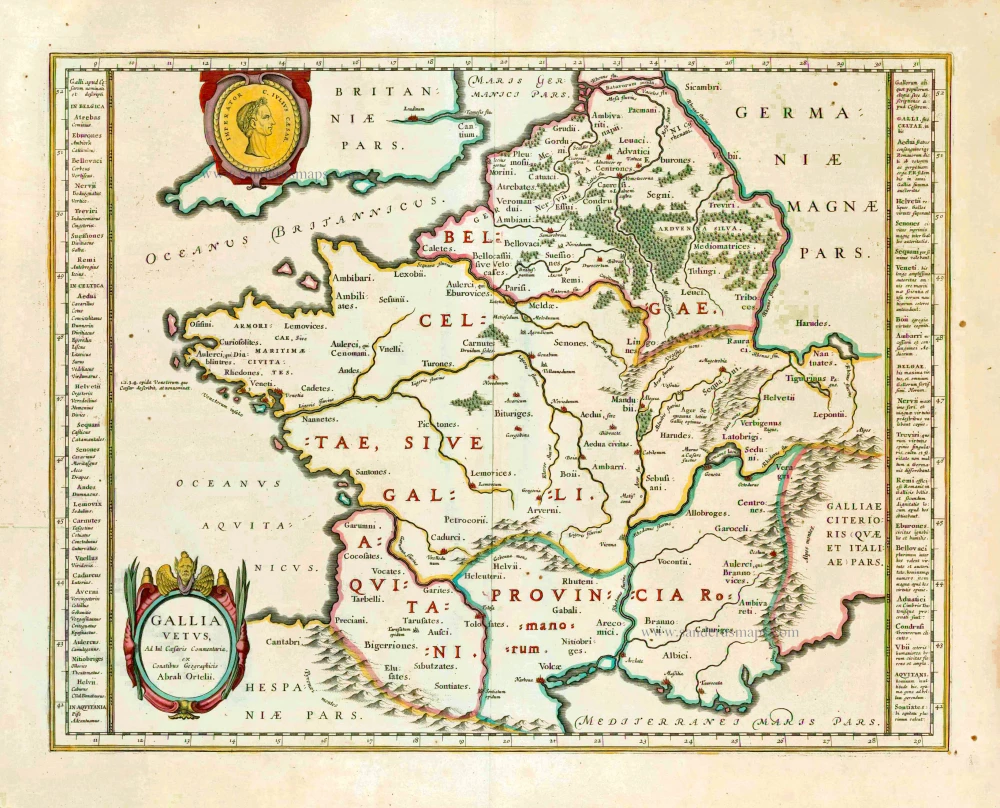
Galliae Veteris Typus.
Item Number: 20936 Authenticity Guarantee
Category: Antique maps > Europe > France
Ancient France by Joannes Janssonius.
Title: Galliae Veteris Typus. - Amstelodami excudit Judocus Hondius.
Amstelodami Apud Ioannem Ianßonium.
Date: 1652-53.
Copper engraving, printed on paper.
Image size: 395 x 490mm (15.55 x 19.29 inches).
Sheet size: 520 x 575mm (20.47 x 22.64 inches).
Verso: French text.
Condition: Original coloured, excellent.
Condition Rating: A+.
From: Nouvel Atlas. J. Janssonius, 1652-53. (Van der Krogt 1, 416)
The Janssonius Family
Joannes Janssonius (Arnhem, 1588-1664), son of the Arnhem publisher Jan Janssen, married Elisabeth Hondius, daughter of Jodocus Hondius, in Amsterdam in 1612. After his marriage, he settled down in this town as a bookseller and publisher of cartographic material. In 1618, he established himself in Amsterdam next door to Blaeu’s bookshop. He entered into serious competition with Willem Jansz. Blaeu when copying Blaeu’s Licht der Zeevaert after the expiration of the privilege in 1620. His activities concerned the publication of atlases, books, single maps, and an extensive book trade with branches in Frankfurt, Danzig, Stockholm, Copenhagen, Berlin, Koningsbergen, Geneva, and Lyon. In 1631, he began publishing atlases together with Henricus Hondius.
In the early 1640s, Henricus Hondius left the atlas publishing business to Janssonius. Competition with Joan Blaeu, Willem’s son and successor, in atlas production, prompted Janssonius to enlarge his Atlas Novus finally into a work of six volumes, into which a sea atlas and an atlas of the Old World were inserted. Other atlases published by Janssonius are Mercator’s Atlas Minor, Hornius’s historical atlas (1652), the townbooks in eight volumes (1657), Cellarius’s Atlas Coelestis and several sea atlases and pilot guides.
After the death of Joannes Janssonius, the shop and publishing firm were continued by the heirs under the direction of Johannes van Waesbergen (c. 1616-1681), son-in-law of Joannes Janssonius. Van Waesbergen added Janssonius's name to his own.
In 1676, Joannes Janssonius’s heirs sold by auction “all the remaining Atlases in Latin, French, High and Low German, as well as the Stedeboecken in Latin, in 8 volumes, bound and unbound, maps, plates belonging to the Atlas and Stedeboecken.” The copperplates from Janssonius’s atlases were afterwards sold to Schenk and Valck.
Related items
Galliae Veteris Typus. 1630
Ancient France by Janssonius J.
[Item number: 6911]

Das gantz Franckreich, so vorzeiten Narbonensis, Lugdunensis, Belgica und Celtica ist genennt worden. 1588
France by Sebastian Münster.
[Item number: 14634]
Galliae seu Franciae Tabula, ... 1683-1696
France, by Visscher N. II.
[Item number: 15637]
Gallia / Per Gerardum Mercatorem. 1609
France, by Gerard Mercator.
[Item number: 19119]

Galliae Veteris. 1601
France, by Ortelius A.
[Item number: 21253]

[No title] 1607
France, by Jodocus Hondius.
[Item number: 25294]

Rare!
Galliae Amplissimi Regni Tabula. 1593
France, by Gerard de Jode.
[Item number: 26035]
Nieuwe Caarte van Vrankryk Met desselfs Conquesten en Limiten by de Ryswykse Vrede Vastgestelt, ... 1730-45
France, by R. & I. Ottens.
[Item number: 26251]
Gallia Vetus. 1640
Ancient France, by Willem Blaeu.
[Item number: 27153]

Description Générale de Toute la France. 1575
France, by François de Belleforest.
[Item number: 27166]

One of the first modern maps of France
[No title] 1525
France, by Lorenz Fries.
[Item number: 27936]

Veronae Vicentiae et Patavii Ditiones. 1623
Verona - Vicenza - Padua, by Gerard Mercator.
[Item number: 27937]
Rare.
Gallia. 1630
France, by Joannes Janssonius.
[Item number: 28022]

Gallia. 1619
France, by Jodocus Hondius.
[Item number: 28840]

Typus Galliae Veteris. 1640
Ancient France, by Willem Blaeu.
[Item number: 28895]

La Francia Antica, e Moderna. 1696
France, by Vincenzo Coronelli.
[Item number: 29296]

Galliae Antiquae Descriptio Geograpfica. 1659
Ancient France by Nicolas Sanson, published by Melchior Tavernier
[Item number: 30031]

Le Royaume de France et ses Acquisitions vers les Pays Bas, l'Allemagne, l'Italie et l'Espagne. 1665
France by Nicolas Sanson.
[Item number: 30082]

Description Nouvelle des Gaules. 1568
France by Sebastian Münster.
[Item number: 30539]

Gallia Vetus, ad Julii Caesaris commentaria. 1595
Ancient France by Ortelius A.
[Item number: 30941]
Extremely rare wall-map of France by C. Tassin, in four sheets
Carte Generalle [sic] de France. 1634-37
France, Christophe Tassin, with a panoramic view of Paris.
[Item number: 30989]

Galliae Veteris. 1624
Ancient France, by Ortelius A.
[Item number: 31191]
Gallia Vetus. c. 1630-1650
Ancient France by Henricus Hondius.
[Item number: 31599]
Gallia - Le Royaume de France. 1642-43
France, by Willem Blaeu.
[Item number: 32434]
Scarce
Accuratissima Galliae Tabula Vulgo Royaume de France. c. 1680
France by Justus Danckerts
[Item number: 32463]