
Scarce
France by Justus Danckerts c. 1680


The Danckerts Family.
The Danckerts family of Amsterdam was one of the best-known print and map sellers in 17th century Amsterdam. Their business activity covered a vast period, from ca. 1633. From 1669 until 1701, father Justus and his sons had their shop in the ‘Calverstraet in de Danckbaerheyt’.
Cornelis Danckerts (1561-1631) was a printseller born in Amsterdam and active in Antwerp.
Cornelis Danckerts, the elder (1603-1656) was an engraver and publisher in Amsterdam and Nieuwendijk. Son of Cornelis (above), whom he succeeded in 1631.
The house of Danckerts gained its greatest fame from Justus Danckerts (1635-1701 - son of Cornelis the elder) and his two sons, Theodorus and Cornelis. Dancker Danckerts (1634-1666), the elder brother of Justus, was known for his etchings of paintings, maps, and publications.
The grandfather, father, and sons were highly skilled and excellent artistic drafters and engravers. They are famous for the edition of their Atlas, which appeared from ca. 1686, and for several monumental and beautiful wall maps and views. However, compared with that published by the Blaeu's or Janssonius's, their cartographic work has attracted little attention and has never received proper recognition.
On 14 August 1684, Justus and his sons obtained the privilege from the States of Holland for their publications. In 1713, twelve years after Justus Danckerts, the heirs decided to sell part of the stock of maps and atlases and many copperplates. In 1727, after the death of the last surviving brother Theodorus, a final sale took place.
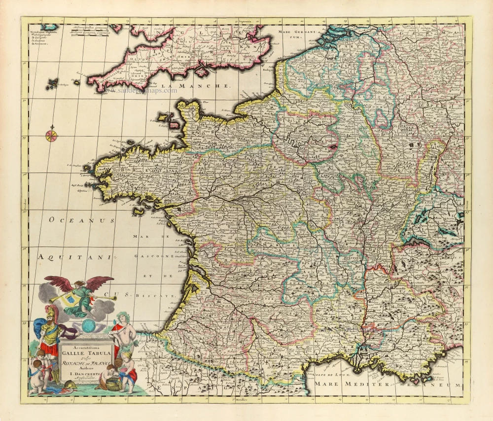
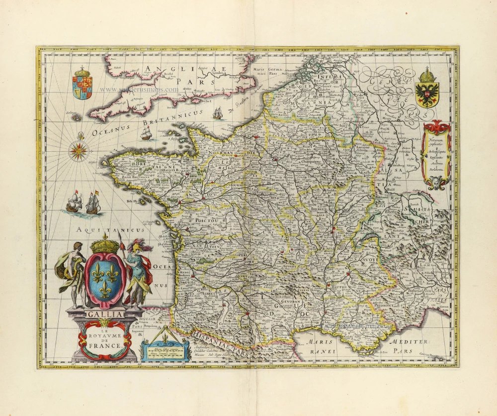
Accuratissima Galliae Tabula Vulgo Royaume de France.
Item Number: 32463 Authenticity Guarantee
Category: Antique maps > Europe > France
France by Justus Danckerts.
Title: Accuratissima Galliae Tabula Vulgo Royaume de France.
Authore I. Danckerts Amstelodami.
Date of the first edition: c. 1680.
Date of this map: c. 1680.
Copper engraving, printed on paper.
Image size: 485 x 565mm (19 x 22¼ inches).
Sheet size: 530 x 630mm (20¾ x 24¾ inches).
Verso: Blank.
Condition: Original coloured, excellent.
Condition Rating: A+.
From: Atlas. Amsterdam, c. 1680. (Koeman II, p. 91, Dan1)
The Danckerts Family.
The Danckerts family of Amsterdam was one of the best-known print and map sellers in 17th century Amsterdam. Their business activity covered a vast period, from ca. 1633. From 1669 until 1701, father Justus and his sons had their shop in the ‘Calverstraet in de Danckbaerheyt’.
Cornelis Danckerts (1561-1631) was a printseller born in Amsterdam and active in Antwerp.
Cornelis Danckerts, the elder (1603-1656) was an engraver and publisher in Amsterdam and Nieuwendijk. Son of Cornelis (above), whom he succeeded in 1631.
The house of Danckerts gained its greatest fame from Justus Danckerts (1635-1701 - son of Cornelis the elder) and his two sons, Theodorus and Cornelis. Dancker Danckerts (1634-1666), the elder brother of Justus, was known for his etchings of paintings, maps, and publications.
The grandfather, father, and sons were highly skilled and excellent artistic drafters and engravers. They are famous for the edition of their Atlas, which appeared from ca. 1686, and for several monumental and beautiful wall maps and views. However, compared with that published by the Blaeu's or Janssonius's, their cartographic work has attracted little attention and has never received proper recognition.
On 14 August 1684, Justus and his sons obtained the privilege from the States of Holland for their publications. In 1713, twelve years after Justus Danckerts, the heirs decided to sell part of the stock of maps and atlases and many copperplates. In 1727, after the death of the last surviving brother Theodorus, a final sale took place.
Related items
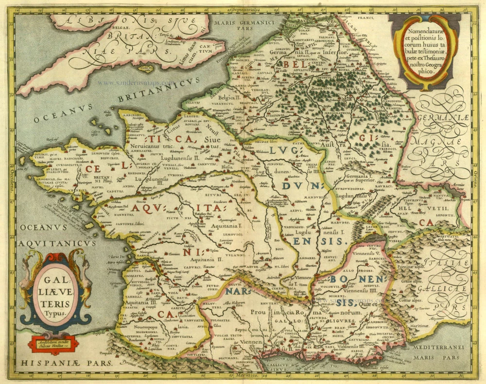
Galliae Veteris Typus. 1630
Ancient France by Janssonius J.
[Item number: 6911]

Das gantz Franckreich, so vorzeiten Narbonensis, Lugdunensis, Belgica und Celtica ist genennt worden. 1588
France by Sebastian Münster.
[Item number: 14634]
Galliae seu Franciae Tabula, ... 1683-1696
France, by Visscher N. II.
[Item number: 15637]
Gallia / Per Gerardum Mercatorem. 1609
France, by Gerard Mercator.
[Item number: 19119]

Galliae Veteris Typus. 1652-53
Ancient France by Joannes Janssonius.
[Item number: 20936]

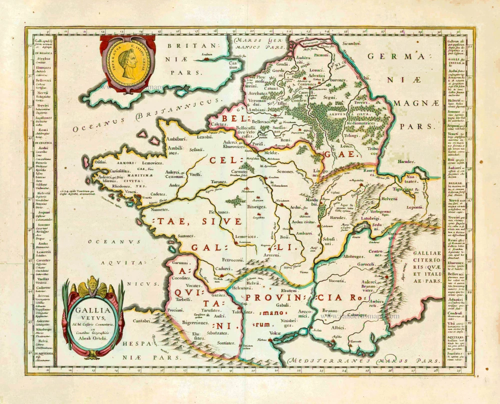
Galliae Veteris. 1601
France, by Ortelius A.
[Item number: 21253]

Rare!
Galliae Amplissimi Regni Tabula. 1593
France, by Gerard de Jode.
[Item number: 26035]
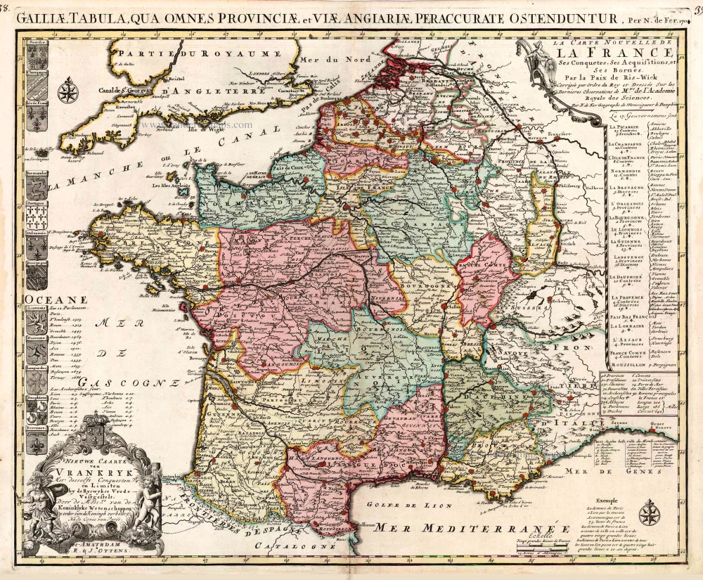
Nieuwe Caarte van Vrankryk Met desselfs Conquesten en Limiten by de Ryswykse Vrede Vastgestelt, ... 1730-45
France, by R. & I. Ottens.
[Item number: 26251]
Gallia Vetus. 1640
Ancient France, by Willem Blaeu.
[Item number: 27153]

Description Générale de Toute la France. 1575
France, by François de Belleforest.
[Item number: 27166]

Gallia. 1619
France, by Jodocus Hondius.
[Item number: 28840]

Typus Galliae Veteris. 1640
Ancient France, by Willem Blaeu.
[Item number: 28895]

La Francia Antica, e Moderna. 1696
France, by Vincenzo Coronelli.
[Item number: 29296]

Galliae Antiquae Descriptio Geograpfica. 1659
Ancient France by Nicolas Sanson, published by Melchior Tavernier
[Item number: 30031]

Le Royaume de France et ses Acquisitions vers les Pays Bas, l'Allemagne, l'Italie et l'Espagne. 1665
France by Nicolas Sanson.
[Item number: 30082]

Description Nouvelle des Gaules. 1568
France by Sebastian Münster.
[Item number: 30539]

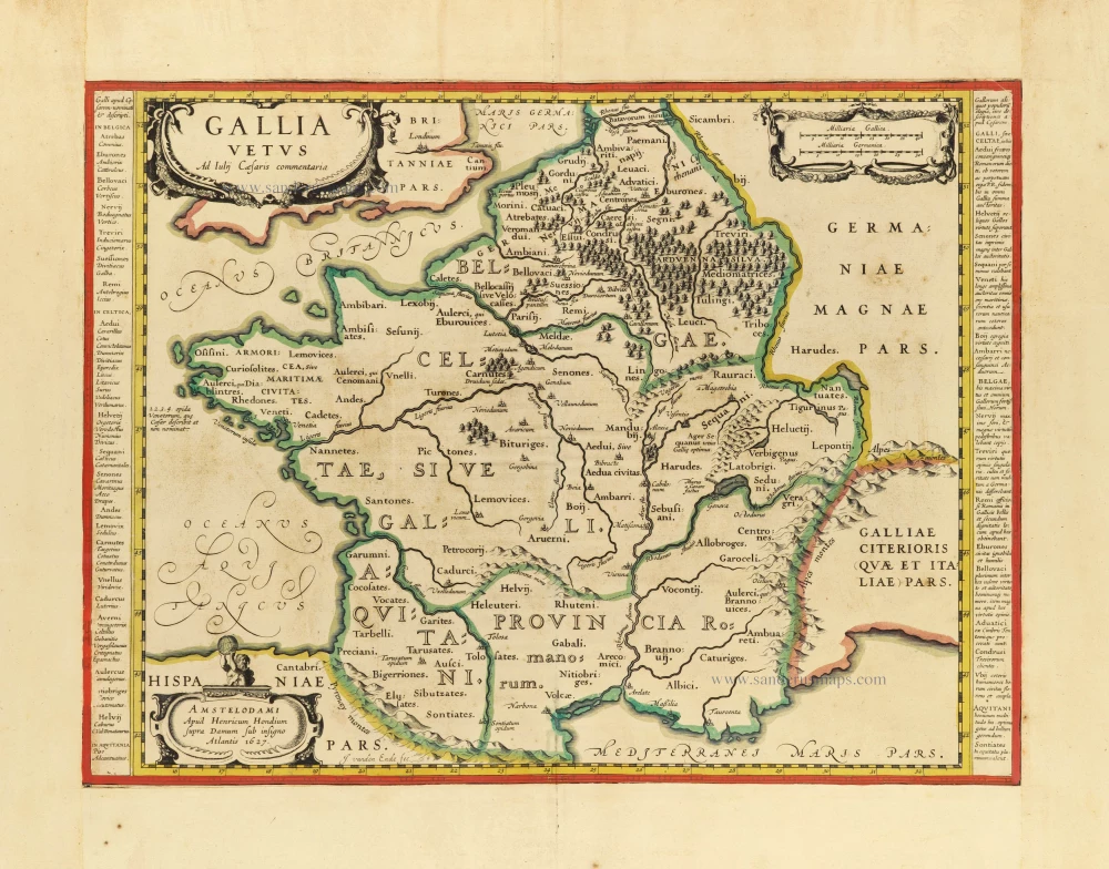
Gallia Vetus, ad Julii Caesaris commentaria. 1595
Ancient France by Ortelius A.
[Item number: 30941]
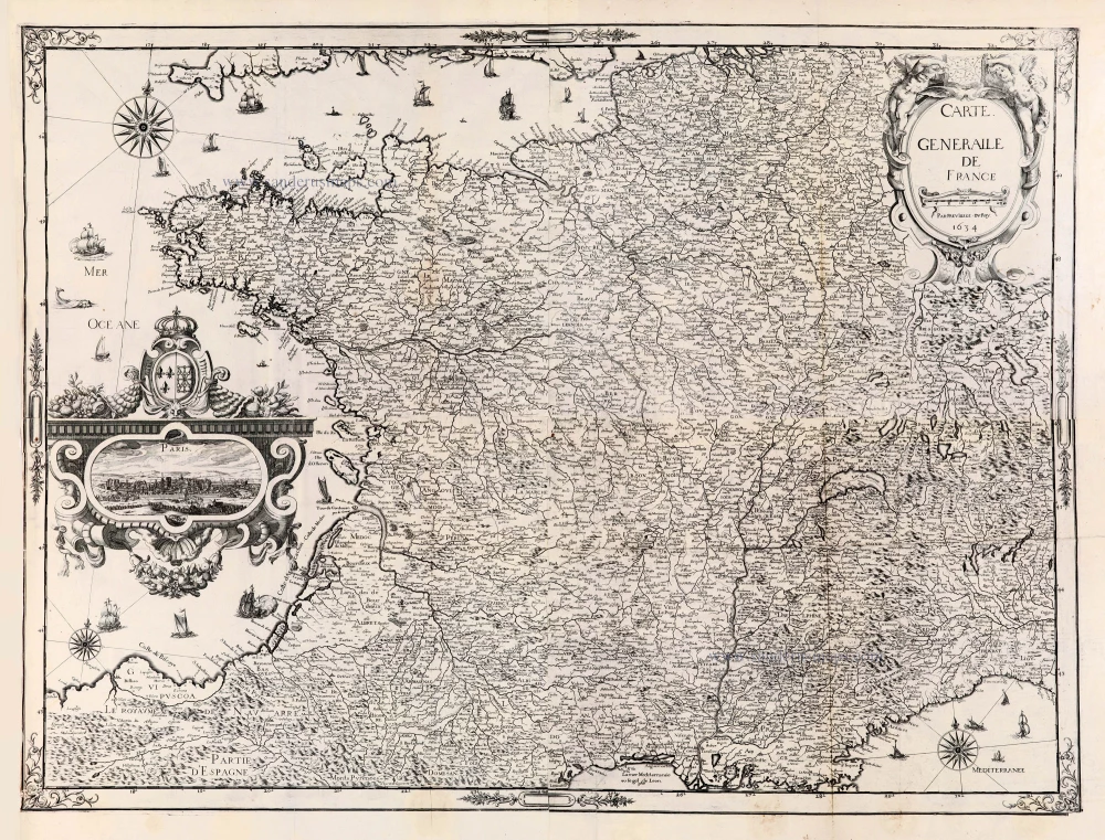
Extremely rare wall-map of France by C. Tassin, in four sheets
Carte Generalle [sic] de France. 1634-37
France, Christophe Tassin, with a panoramic view of Paris.
[Item number: 30989]

Galliae Veteris. 1624
Ancient France, by Ortelius A.
[Item number: 31191]

Gallia - Nova totius Galliae geographica descriptio, ... Ineaque archiepiscopatus, episcopatus omnes, academiae item et parlamenta singula suis quaequae notis distincta a Iuodoco Hondio. c. 1610-1650
France by Jodocus Hondius, published by Melchior Tavernier.
[Item number: 31308]

Galliae Veteris Typus. c. 1610-1650
Ancient France by Jodocus Hondius
[Item number: 31312]
Gallia Vetus. c. 1630-1650
Ancient France by Henricus Hondius.
[Item number: 31599]
Gallia - Le Royaume de France. 1642-43
France, by Willem Blaeu.
[Item number: 32434]