
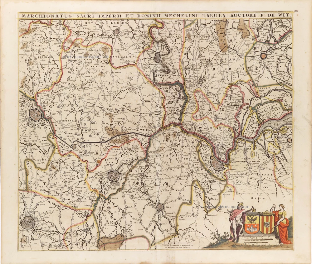
The marquisate of Antwerp and the manor of Mechelen, by Frederick de Wit. c. 1705


Frederick de Wit (1630-1706)
The engraver and map-seller, Frederick de Wit, was born in Gouda (Netherlands) in 1630 as a son of Hendrick Fredericksz de Wit. Through his marriage with Maria van der Waag of Amsterdam in 1661, he obtained citizenship of the city where he had been working since 1648 and where he became one of the most famous engravers of maps of the second half of the 17th century. Although De Wit was a Catholic, which meant that he was not favoured at the time by the city council, he was awarded the honour of being listed as one of the "excellent citizens" on the roll of the city council in the years 1694-1704. However, his name was not written in the Guild of St. Luke book before 1664. At that time, he lived on the Kalverstraat "in de Witte Pascaert", where he stayed until his death in 1706. His earliest dates on maps engraved are 1659 (Regni Daniae) and 1660 (World map).
Frederick de Wit published several world atlases, a sea atlas, and an atlas of the Netherlands.
The dating of the maps is difficult. However, as a privilege was granted in 1689, the annotation 'cum privilegio' marks an edition after 1688.
Around 1700, Frederick de Wit entered the market with a town atlas. He produced two volumes with a total of 260 plans and views. Most were printed from plates used for Janssonius and Blaeu town atlases.
After he died in 1706, his widow continued the shop until 1709. The plates and stock of De Wit's atlas were sold to Covens & Mortier in 1710, who sold the atlas for an extended period.
Marchionatus Sacri Imperiit Dominii Mechelini Tabula.
Item Number: 28997 Authenticity Guarantee
Category: Antique maps > Europe > Belgium
Antique map of the marquisate of Antwerp and the manor of Mechelen, by Frederick de Wit.
Title: Marchionatus Sacri Imperiit Dominii Mechelini Tabula.
Auctore F. De Wit.
Gedrukt tot Amsterdam by Frederick de Wit inde Kalverstraet inde Witte Paskaert.
Oriented to the west.
Date of the first edition: ca. 1666-67.
Date of this map: c. 1705.
Copper engraving, printed on paper.
Map size: 490 x 565mm (19.29 x 22.24 inches).
Sheet size: 540 x 630mm (21.26 x 24.8 inches).
Verso: Blank.
Condition: Original coloured, vertical crease along centrefold.
Condition Rating: A.
From: Atlas. Amsterdam, Frederick de Wit, after 1705. (Koeman, III p. 202, Wit16; Carhart p. 159 A157)
Frederick de Wit (1630-1706)
The engraver and map-seller, Frederick de Wit, was born in Gouda (Netherlands) in 1630 as a son of Hendrick Fredericksz de Wit. Through his marriage with Maria van der Waag of Amsterdam in 1661, he obtained citizenship of the city where he had been working since 1648 and where he became one of the most famous engravers of maps of the second half of the 17th century. Although De Wit was a Catholic, which meant that he was not favoured at the time by the city council, he was awarded the honour of being listed as one of the "excellent citizens" on the roll of the city council in the years 1694-1704. However, his name was not written in the Guild of St. Luke book before 1664. At that time, he lived on the Kalverstraat "in de Witte Pascaert", where he stayed until his death in 1706. His earliest dates on maps engraved are 1659 (Regni Daniae) and 1660 (World map).
Frederick de Wit published several world atlases, a sea atlas, and an atlas of the Netherlands.
The dating of the maps is difficult. However, as a privilege was granted in 1689, the annotation 'cum privilegio' marks an edition after 1688.
Around 1700, Frederick de Wit entered the market with a town atlas. He produced two volumes with a total of 260 plans and views. Most were printed from plates used for Janssonius and Blaeu town atlases.
After he died in 1706, his widow continued the shop until 1709. The plates and stock of De Wit's atlas were sold to Covens & Mortier in 1710, who sold the atlas for an extended period.
Related items
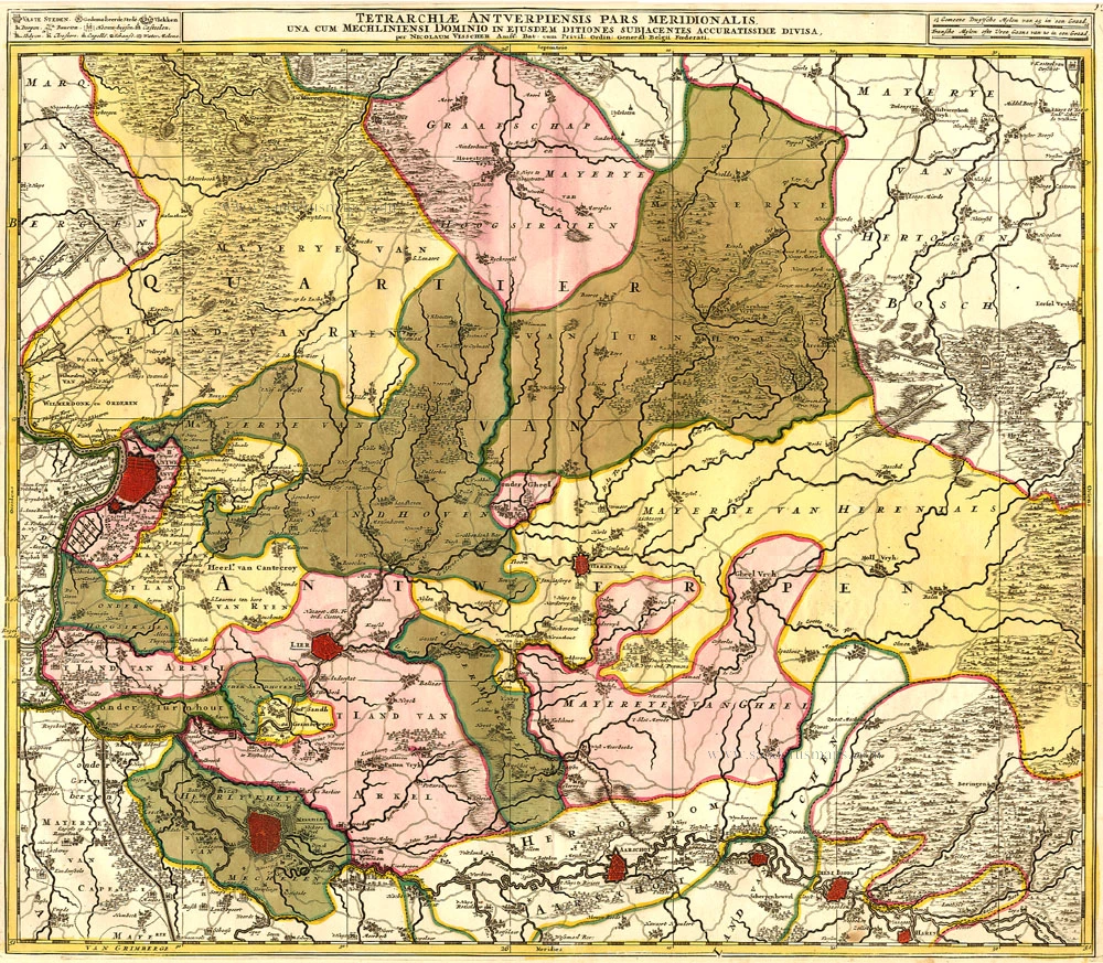
Tetrarchiae Antverpiensis Pars Meridionalis 1683-1696
Antwerpen - Mechelen by Visscher N. II.
[Item number: 14777]

Tertia Pars Brabantiae qua continetur Marchionat S.R.I. horum urbs primaria Antverpia. 1641-42
The Marquisate of Antwerp, by Willem Blaeu.
[Item number: 17537]

Marchionatus Sacri Imperiit Dominii Mechelini Tabula 1721-41
Mechelen - Antwerpen, by Covens & Mortier.
[Item number: 23690]

Dioecesis Episcopatus Anverpiensis. Before 1678
Diocese of Antwerp by Petrus Verbiest.
[Item number: 30172]

Mechlinia. 1617
Mechelen by Petrus Van den Keere (Kaerius).
[Item number: 30655]

One of Antwerp's most beautiful maps
Marchionatus Sacri Romani Imperii. c. 1760
Antwerp, by Nicolaes Visscher I, published by Petrus Schenk Jr.
[Item number: 31137]

Antwerpen. 1686
Antwerpen by Christoph Riegel.
[Item number: 31503]

Le Pourtraict de la tres noble ville d'Anvers, ainsi qu'elle se comporte a present. 1575
Antwerp (Antwerpen), by François de Belleforest.
[Item number: 31871]

Carte de la Seigneyrie de Malines. 1633
Mechelen by Christophe Tassin.
[Item number: 31931]

Marchionatus Sacri Romani Imperii. 1617
Antwerp (Antwerpen), by Petrus Kaerius.
[Item number: 32003]

Spectacular view by Hoefnagel
Antverpia. 1596
Antwerp, by Georg Braun and Frans Hogenberg, after G. Hoefnagel.
[Item number: 32468]

Port d'Anvers 1823
Antwerpen, lithograph by Dewasme, after Prosper de la Barrière.
[Item number: 33108]
new

Marché aux Poissons, à Anvers. 1823
Antwerpen - Vismarkt, lithograph by Dewasme, after Prosper de la Barrière.
[Item number: 33109]