
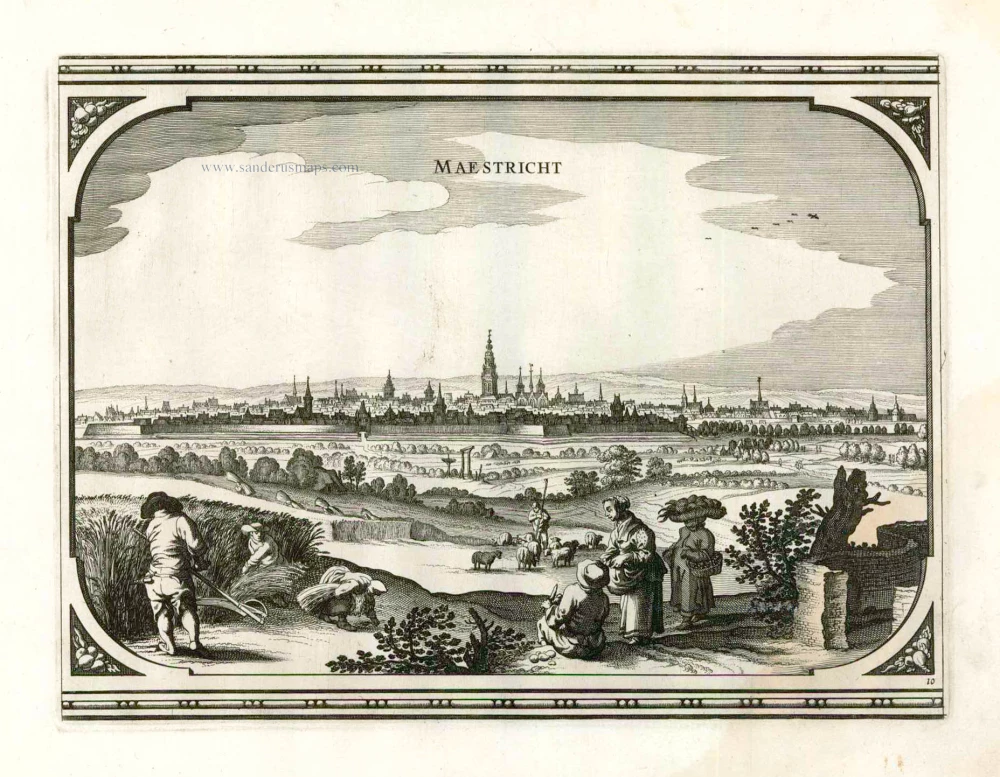
Maastricht, by Georg Braun and Frans Hogenberg. 1581

COMMENTARY BY BRAUN: "Turning proudly to our age, our founder and the name of our patron saint, we must point out that we were founded around the year 78 BC and owe our origins to Julius Caesar and our name [Lat. Traiectum ad Mosam, "Meuse crossing"] to the fact that the River Meuse can be crossed here [...] and that we also owe much to St Servatius, the first to hold the office of bishop in this city."
Maastricht is presented in a topographically accurate bird's-eye view from the south that affords a clear view of the city centre. Rising on Vrijthof square is the dominant complex of Sint-Servaas, in front of which - seen here in a distorted perspective - is the church of Sint-Jan.
Braun G. & Hogenberg F. and the Civitates Orbis Terrarum.
The Civitates Orbis Terrarum, also known as the 'Braun & Hogenberg', is a six-volume town atlas and the most excellent book of town views and plans ever published: 363 engravings, sometimes beautifully coloured. It was one of the best-selling works in the last quarter of the 16th century. Georg Braun, a skilled writer, wrote the text accompanying the plans and views on the verso. Many plates were engraved after the original drawings of a professional artist, Joris Hoefnagel (1542-1600). The first volume was published in Latin in 1572 and the sixth in 1617. Frans Hogenberg, a talented engraver, created the tables for volumes I through IV, and Simon van den Neuwel made those for volumes V and VI. Other contributors were cartographers Daniel Freese and Heinrich Rantzau, who provided valuable geographical information. Works by Jacob van Deventer, Sebastian Münster, and Johannes Stumpf were also used as references. Translations appeared in German and French, making the atlas accessible to a broader audience.
Since its original publication of volume 1 in 1572, the Civitates Orbis Terrarum has left an indelible mark on the history of cartography. Seven more editions followed the first volume in 1575, 1577, 1582, 1588, 1593, 1599, and 1612. Vol.2, initially released in 1575, saw subsequent editions in 1597 and 1612. The subsequent volumes, each a treasure trove of historical insights, graced the world in 1581, 1588, 1593, 1599, and 1606. The German translation of the first volume, a testament to its widespread appeal, debuted in 1574, followed by the French edition in 1575.
Several printers were involved: Theodor Graminaeus, Heinrich von Aich, Gottfried von Kempen, Johannis Sinniger, Bertram Buchholtz, and Peter von Brachel, all of whom worked in Cologne.
Georg Braun (1541-1622)
Georg Braun, the author of the text accompanying the plans and views in the Civitates Orbis Terrarum, was born in Cologne in 1541. After his studies in Cologne, he entered the Jesuit Order as a novice, indicating his commitment to learning and intellectual pursuits. In 1561, he obtained his bachelor's degree; in 1562, he received his Magister Artium, further demonstrating his academic achievements. Although he left the Jesuit Order, he continued his studies in theology, gaining a licentiate in theology. His theological background likely influenced the content and tone of the text in the Civitates Orbis Terrarum, adding a unique perspective to the work.
Frans Hogenberg (1535-1590)
Frans Hogenberg was a Flemish and German painter, engraver, and mapmaker. He was born in Mechelen as the son of Nicolaas Hogenberg.
By the end of the 1560s, Frans Hogenberg was employed upon Abraham Ortelius's Theatrum Orbis Terrarum, published in 1570; he is named an engraver of numerous maps. In 1568, he was banned from Antwerp by the Duke of Alva and travelled to London, where he stayed a few years before emigrating to Cologne. He immediately embarked on his two most important works, the Civitates, published in 1572 and the Geschichtsblätter, which appeared in several series from 1569 until about 1587.
Thanks to large-scale projects like the Geschichtsblätter and the Civitates, Hogenberg's social circumstances improved with each passing year. He died as a wealthy man in Cologne in 1590.
Maestricht - Traiectum ad Mosam.
Item Number: 21546 Authenticity Guarantee
Category: Antique maps > Europe > The Netherlands - Cities
Antique map - Bird's-eye view plan of Maastricht by Braun and Hogenberg.
Title: Maestricht - Traiectum ad Mosam.
Date of the first edition: 1581.
Date of this map: 1581.
Copper engraving, printed on paper.
Size (not including margins): 355 x 415mm (13.98 x 16.34 inches).
Verso: Latin text.
Condition: Uncoloured, excellent.
Condition Rating: A.
From: Civitates Orbis Terrarum. . Liber tertius. Cologne, Gottfried von Kempen, 1581. (Van der Krogt 4, 41:1.3)
COMMENTARY BY BRAUN: "Turning proudly to our age, our founder and the name of our patron saint, we must point out that we were founded around the year 78 BC and owe our origins to Julius Caesar and our name [Lat. Traiectum ad Mosam, "Meuse crossing"] to the fact that the River Meuse can be crossed here [...] and that we also owe much to St Servatius, the first to hold the office of bishop in this city."
Maastricht is presented in a topographically accurate bird's-eye view from the south that affords a clear view of the city centre. Rising on Vrijthof square is the dominant complex of Sint-Servaas, in front of which - seen here in a distorted perspective - is the church of Sint-Jan.
Braun G. & Hogenberg F. and the Civitates Orbis Terrarum.
The Civitates Orbis Terrarum, also known as the 'Braun & Hogenberg', is a six-volume town atlas and the most excellent book of town views and plans ever published: 363 engravings, sometimes beautifully coloured. It was one of the best-selling works in the last quarter of the 16th century. Georg Braun, a skilled writer, wrote the text accompanying the plans and views on the verso. Many plates were engraved after the original drawings of a professional artist, Joris Hoefnagel (1542-1600). The first volume was published in Latin in 1572 and the sixth in 1617. Frans Hogenberg, a talented engraver, created the tables for volumes I through IV, and Simon van den Neuwel made those for volumes V and VI. Other contributors were cartographers Daniel Freese and Heinrich Rantzau, who provided valuable geographical information. Works by Jacob van Deventer, Sebastian Münster, and Johannes Stumpf were also used as references. Translations appeared in German and French, making the atlas accessible to a broader audience.
Since its original publication of volume 1 in 1572, the Civitates Orbis Terrarum has left an indelible mark on the history of cartography. Seven more editions followed the first volume in 1575, 1577, 1582, 1588, 1593, 1599, and 1612. Vol.2, initially released in 1575, saw subsequent editions in 1597 and 1612. The subsequent volumes, each a treasure trove of historical insights, graced the world in 1581, 1588, 1593, 1599, and 1606. The German translation of the first volume, a testament to its widespread appeal, debuted in 1574, followed by the French edition in 1575.
Several printers were involved: Theodor Graminaeus, Heinrich von Aich, Gottfried von Kempen, Johannis Sinniger, Bertram Buchholtz, and Peter von Brachel, all of whom worked in Cologne.
Georg Braun (1541-1622)
Georg Braun, the author of the text accompanying the plans and views in the Civitates Orbis Terrarum, was born in Cologne in 1541. After his studies in Cologne, he entered the Jesuit Order as a novice, indicating his commitment to learning and intellectual pursuits. In 1561, he obtained his bachelor's degree; in 1562, he received his Magister Artium, further demonstrating his academic achievements. Although he left the Jesuit Order, he continued his studies in theology, gaining a licentiate in theology. His theological background likely influenced the content and tone of the text in the Civitates Orbis Terrarum, adding a unique perspective to the work.
Frans Hogenberg (1535-1590)
Frans Hogenberg was a Flemish and German painter, engraver, and mapmaker. He was born in Mechelen as the son of Nicolaas Hogenberg.
By the end of the 1560s, Frans Hogenberg was employed upon Abraham Ortelius's Theatrum Orbis Terrarum, published in 1570; he is named an engraver of numerous maps. In 1568, he was banned from Antwerp by the Duke of Alva and travelled to London, where he stayed a few years before emigrating to Cologne. He immediately embarked on his two most important works, the Civitates, published in 1572 and the Geschichtsblätter, which appeared in several series from 1569 until about 1587.
Thanks to large-scale projects like the Geschichtsblätter and the Civitates, Hogenberg's social circumstances improved with each passing year. He died as a wealthy man in Cologne in 1590.
Related items
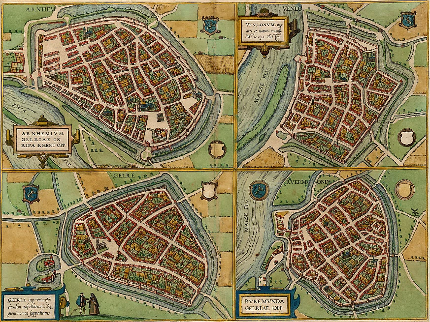
Arnhemium (on sheet with) Venlonum (and) Gelria (and) Ruremunda 1588
Arnhem, Venlo, Gelre, Roermond, by Georg Braun and Frans Hogenberg.
[Item number: 2009]
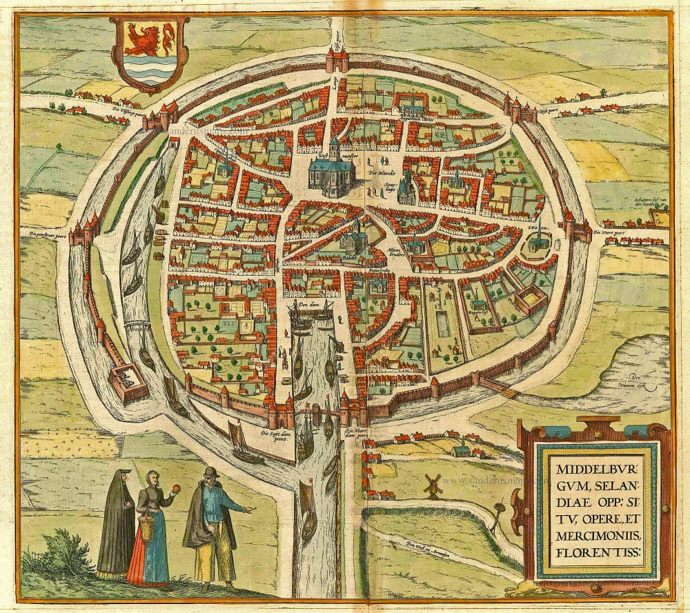
Middelburgum, Selandiae Opp: Situ, Opere, et Mercimoniis, Florentiss: 1575
Middelburg by Braun & Hogenberg
[Item number: 4669]

Groninga, opulenta, populosa, et valide contra hostiles insultus munita Phrisie urbs, ... 1575
Groningen, by Georg Braun and Frans Hogenberg.
[Item number: 8108]
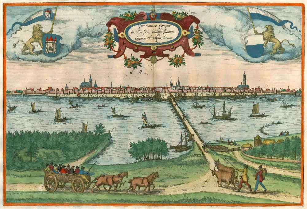
Icon civitatis Campensis, cuius situs Isulam fluvium, eleganti venustate, decorat 1575
Kampen, by Georg Braun and Frans Hogenberg.
[Item number: 9364]
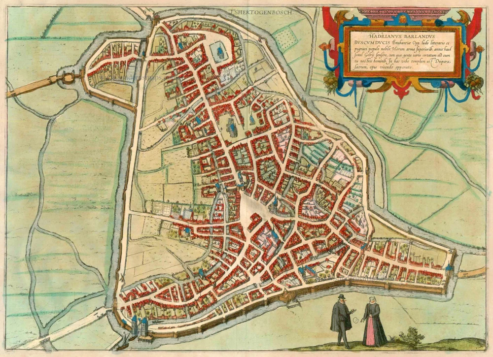
t's Hertogenbosch 1612
s-Hertogenbosch by Braun & Hogenberg
[Item number: 13655]

Urbis Campensis ad Isalam Fluvium Icon. 1581-88
Kampen, by Georg Braun and Frans Hogenberg.
[Item number: 22215]

Roterodamum. 1588-97
Rotterdam, by Georg Braun and Frans Hogenberg.
[Item number: 22257]
Maestricht. 1656
Maastricht, by Visscher N. - Schut P.H.
[Item number: 25378]
Mastricht 1721-33
Maastricht by David Fassmann.
[Item number: 28167]