Newfoundland by James Cook and Michael Lane, published by Thomas Jefferys. 1775
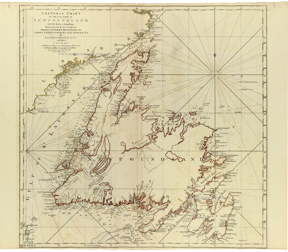
An important and highly detailed nautical chart of Newfoundland, based on the pioneering hydrographic surveys of James Cook (1728–1779) and Michael Lane, published in London by Thomas Jefferys in 1775.
The map depicts the entire island of Newfoundland, together with the surrounding coastal waters, extending from the Strait of Belle Isle in the north to Cape Race and Cape Breton in the south. The coastline is represented with remarkable precision, identifying numerous bays, harbours, capes, islands, rocks, shoals, and navigational hazards. Particularly detailed are the western and northern coasts, the Bay of Islands, St. George's Bay, Notre Dame Bay, Bonavista Bay, Trinity Bay, Placentia Bay, and the Avalon Peninsula.
The chart incorporates an extensive network of rhumb lines radiating from compass centres, together with numerous soundings and indications of offshore banks and fishing grounds. The interior of Newfoundland remains relatively sparsely mapped, reflecting the predominantly maritime purpose of the surveys and the limited European geographical knowledge of the island's interior during the eighteenth century.
The map is of particular historical importance because of its association with James Cook, who, before achieving worldwide fame through his Pacific voyages, spent several years surveying the coasts of Newfoundland. Between 1763 and 1767, Cook carried out extensive hydrographic surveys under the authority of the British Admiralty, producing some of the most accurate charts of the region then available. His work was subsequently continued and supplemented by Michael Lane, who had served under Cook and became an accomplished hydrographic surveyor in his own right.
These surveys were of considerable strategic and economic importance. Following the Treaty of Paris in 1763, Newfoundland became an increasingly significant centre of British maritime activity, particularly in connection with the lucrative North Atlantic fisheries. Accurate coastal charts were essential for navigation, naval operations, and the protection of British commercial interests.
The chart was published by Thomas Jefferys, Geographer to King George III, and subsequently appeared in The American Atlas, issued by Robert Sayer and John Bennett in London. The map represents an important achievement in eighteenth-century British hydrography and is among the notable cartographic works associated with Cook's early career.
A fine and historically significant chart, documenting James Cook's pioneering surveys of Newfoundland before his celebrated voyages of exploration in the Pacific.
Thomas Jefferys (c. 1719-1771)
Thomas Jefferys was an outstanding English cartographer who was the leading map supplier of his day. He engraved and printed maps for government and other official bodies and produced a wide range of commercial maps and atlases. He made some of the finest maps of the time of North America and the West Indies.
He was appointed Geographer to the Prince of Wales and George II. However, in 1766, he became bankrupt and subsequently, the publication of his maps was managed by Robert Sayer, who in 1774 was joined in partnership by John Bennett and William Faden.
A General Chart of the Island of Newfoundland with the Rocks & Soundings.
Item Number: 33364 new Authenticity Guarantee
Category: Antique maps > America > North America
Newfoundland by James Cook and Michael Lane, published by Thomas Jefferys.
Title: A General Chart of the Island of Newfoundland with the Rocks & Soundings.
Drawn from Surveys taken by Order of the Right Honourable the Lords Commissioners of the Admiralty by James Cook and Michael Lane, Surveyors and Others.
London. Published according to Act of Parliament, 10th May 1775.
By Thomas Jefferys Geographer to the King.
Printed for Rob.t Sayer & Jn Bennett. N° 53 in Fleet Street.
Date of the first edition: 1770.
Date of this map: 1775.
Date on map: 1775.
Copper engraving, printed on paper.
Image size: 545 x 560mm (21½ x 22 inches).
Sheet size: 555 x 745mm (21¾ x 29¼ inches).
Verso: Blank.
Condition: Original coloured in outline, some light offsetting.
Condition Rating: A+.
From: Jefferys Thomas, The American Atlas. London, 1775. (Tooley (Brit.Lib.), T.JEF-2b).
An important and highly detailed nautical chart of Newfoundland, based on the pioneering hydrographic surveys of James Cook (1728–1779) and Michael Lane, published in London by Thomas Jefferys in 1775.
The map depicts the entire island of Newfoundland, together with the surrounding coastal waters, extending from the Strait of Belle Isle in the north to Cape Race and Cape Breton in the south. The coastline is represented with remarkable precision, identifying numerous bays, harbours, capes, islands, rocks, shoals, and navigational hazards. Particularly detailed are the western and northern coasts, the Bay of Islands, St. George's Bay, Notre Dame Bay, Bonavista Bay, Trinity Bay, Placentia Bay, and the Avalon Peninsula.
The chart incorporates an extensive network of rhumb lines radiating from compass centres, together with numerous soundings and indications of offshore banks and fishing grounds. The interior of Newfoundland remains relatively sparsely mapped, reflecting the predominantly maritime purpose of the surveys and the limited European geographical knowledge of the island's interior during the eighteenth century.
The map is of particular historical importance because of its association with James Cook, who, before achieving worldwide fame through his Pacific voyages, spent several years surveying the coasts of Newfoundland. Between 1763 and 1767, Cook carried out extensive hydrographic surveys under the authority of the British Admiralty, producing some of the most accurate charts of the region then available. His work was subsequently continued and supplemented by Michael Lane, who had served under Cook and became an accomplished hydrographic surveyor in his own right.
These surveys were of considerable strategic and economic importance. Following the Treaty of Paris in 1763, Newfoundland became an increasingly significant centre of British maritime activity, particularly in connection with the lucrative North Atlantic fisheries. Accurate coastal charts were essential for navigation, naval operations, and the protection of British commercial interests.
The chart was published by Thomas Jefferys, Geographer to King George III, and subsequently appeared in The American Atlas, issued by Robert Sayer and John Bennett in London. The map represents an important achievement in eighteenth-century British hydrography and is among the notable cartographic works associated with Cook's early career.
A fine and historically significant chart, documenting James Cook's pioneering surveys of Newfoundland before his celebrated voyages of exploration in the Pacific.
Thomas Jefferys (c. 1719-1771)
Thomas Jefferys was an outstanding English cartographer who was the leading map supplier of his day. He engraved and printed maps for government and other official bodies and produced a wide range of commercial maps and atlases. He made some of the finest maps of the time of North America and the West Indies.
He was appointed Geographer to the Prince of Wales and George II. However, in 1766, he became bankrupt and subsequently, the publication of his maps was managed by Robert Sayer, who in 1774 was joined in partnership by John Bennett and William Faden.