
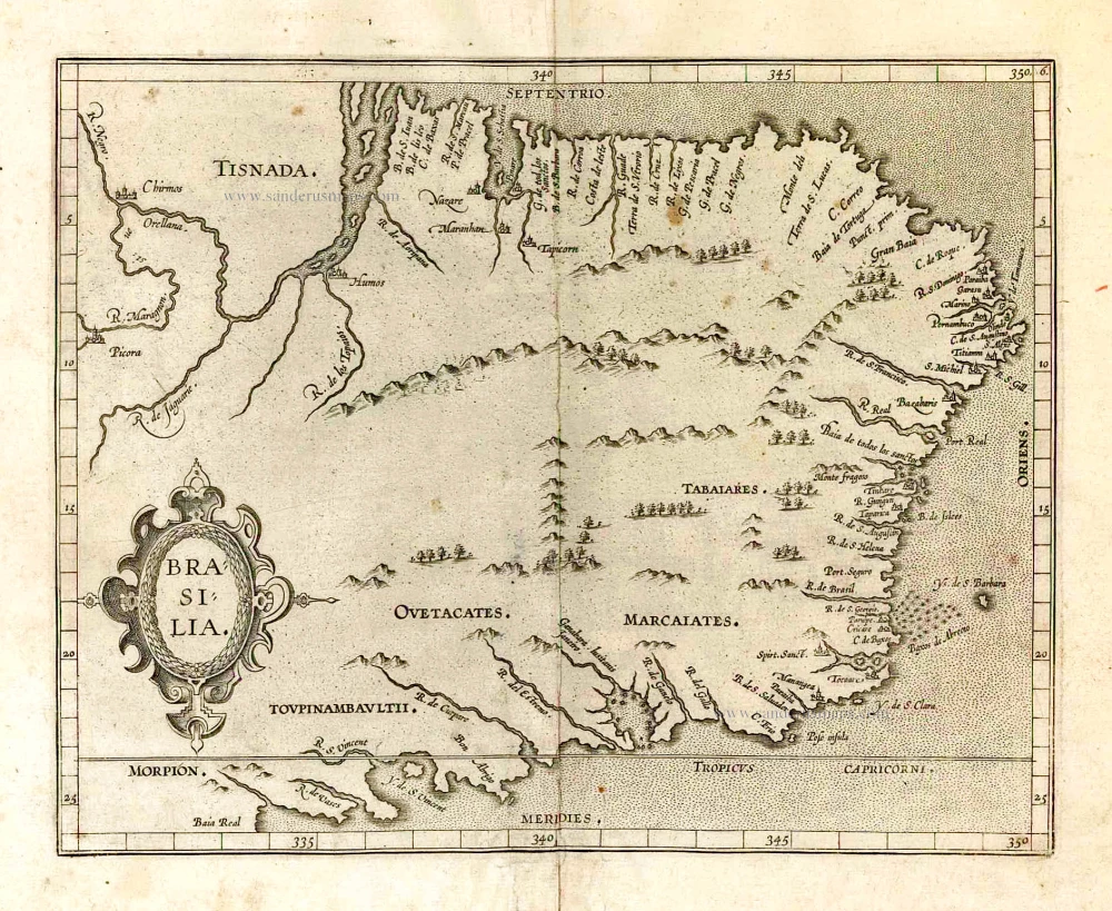
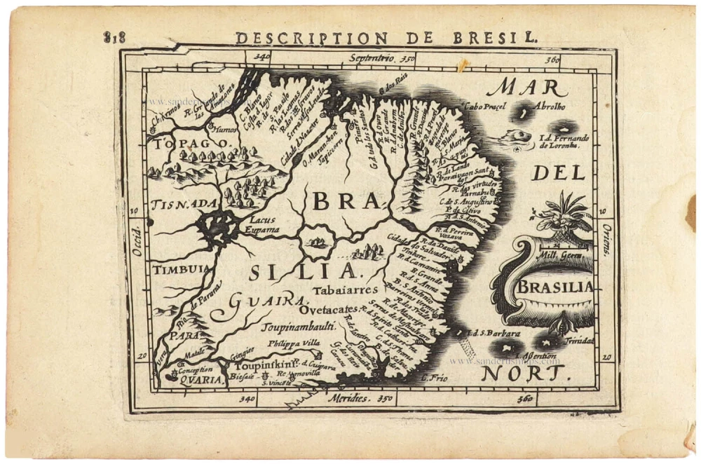
Brazil by Girolamo Ruscelli. 1598

Shows a scene with cannibals roasting a human leg on a spit.
Girolamo Ruscelli (1504 (1518?) -1566)
Girolamo Ruscelli was an Italian mathematician and cartographer who worked in Venice in the early 16th century. He was also an alchemist who wrote pseudonymously as Alessio Piemontese.
He published a translation of the Geografia of Ptolemy, printed in Venice by Vincenzo Valgrisi in 1561. It was a quarto edition with Ptolemaic and modern maps. The engravers may have been the brothers Giulio and Livio Sanuto. Among the 69 copperplate maps were 40 based on maps by Giacomo Gastaldi. The maps were re-issued in 1562, 1564, 1574 and 1598.
Brasil Nuova Tavola.
Item Number: 28430 Authenticity Guarantee
Category: Antique maps > America > South America
Old, antique map of Brazil, by Ruscelli Girolamo.
Title: Brasil Nuova Tavola.
Oriented to the west.
Date of the first edition: 1561.
Date of this map: 1598.
Copper engraving, printed on paper.
Map size: 190 x 260mm (7.48 x 10.24 inches).
Sheet size: 245 x 350mm (9.65 x 13.78 inches).
Verso: Italian text.
Condition: Sharp impression, excellent.
Condition Rating: A+.
From: La Geografia di Claudio Tolomeo Alessandrino, Tradotta di Greco nell'Idioma Volgare Italiano da M. Girolamo Ruscelli, et hora nouvamente ampliata da Gioseffo Rosaccio ... In Venetia, MDXCVIII [1598]. (Shirley (Brit. Lib.), T.PTOL-10f)
Shows a scene with cannibals roasting a human leg on a spit.
Girolamo Ruscelli (1504 (1518?) -1566)
Girolamo Ruscelli was an Italian mathematician and cartographer who worked in Venice in the early 16th century. He was also an alchemist who wrote pseudonymously as Alessio Piemontese.
He published a translation of the Geografia of Ptolemy, printed in Venice by Vincenzo Valgrisi in 1561. It was a quarto edition with Ptolemaic and modern maps. The engravers may have been the brothers Giulio and Livio Sanuto. Among the 69 copperplate maps were 40 based on maps by Giacomo Gastaldi. The maps were re-issued in 1562, 1564, 1574 and 1598.
Related items
Important map in excellent condition
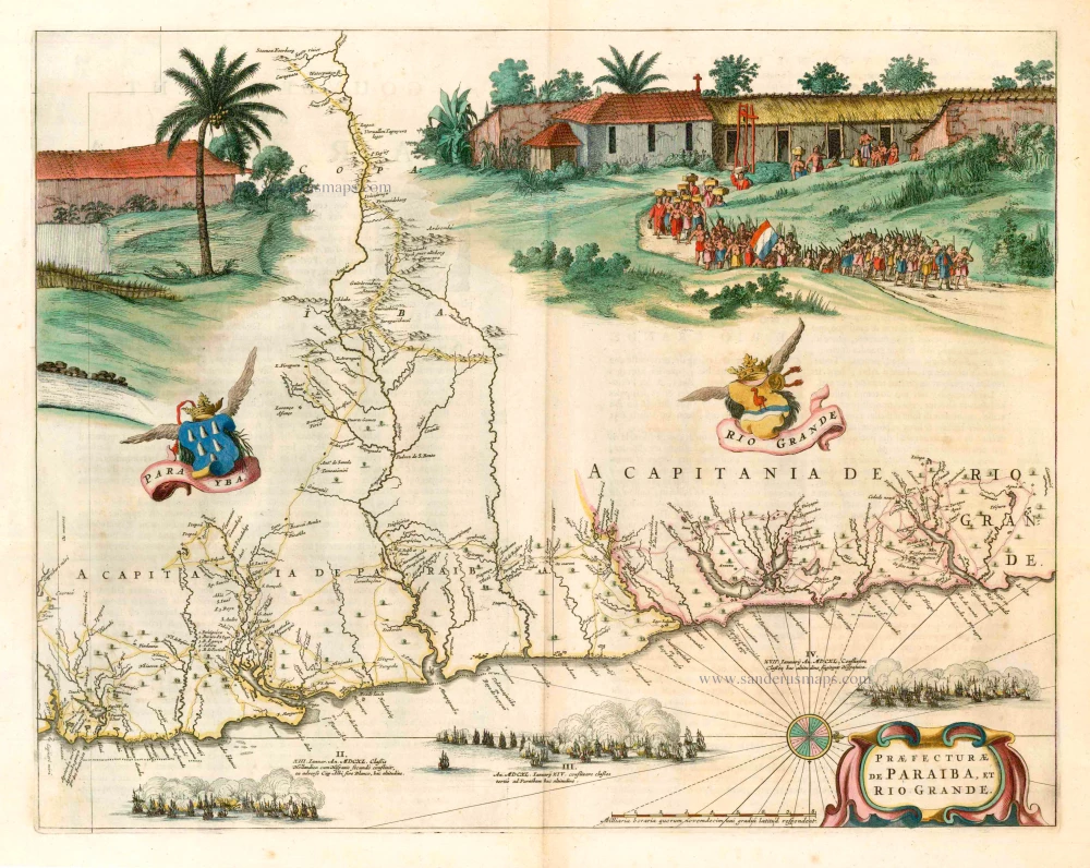
Praefecturae de Paraiba, et Rio Grande. 1663
Brazil - Paraiba, by Joan Blaeu.
[Item number: 25258]

Provincia de Brasil cum Adiacentibus Provinciis. 1630
Brazil, by Johannes de Laet.
[Item number: 25390]

Brasil. 1563
Brazil, by Ramusio G.B.
[Item number: 26186]
Brasilia. 1607
Brazil, by C. van Wytfliet.
[Item number: 26509]

With cannibals
Brasilia. 1602
Brazil by Langenes, published by Bertius P.
[Item number: 26537]

Brasilia. 1645
Brazil, by Joan Blaeu.
[Item number: 29707]
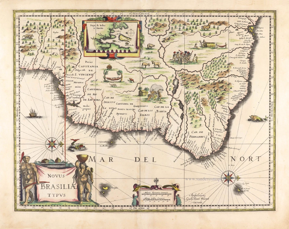
Novus Brasiliae Typus. c. 1640
Brazil, by Willem Blaeu.
[Item number: 29848]
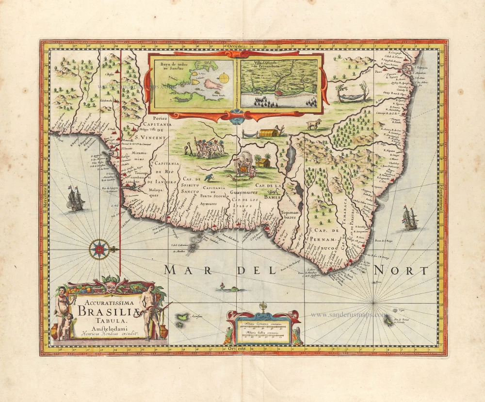
Accuratissima Brasiliae Tabula. 1638
Brazil by Henricus Hondius.
[Item number: 29851]
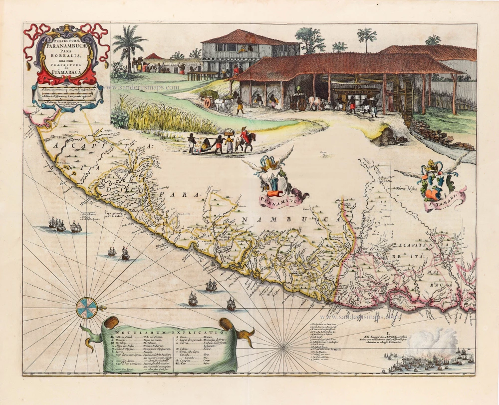
Praefecturae Paranambucae, pars Borealis, una cum Praefectura de Itâmarcâ. 1663
Brazil - Pernambuco (North) by Joan Blaeu.
[Item number: 30149]

Unrecorded view of Pernambuco (Brazil) by Carel Allard
Paranbuca. 1673
View of Pernambuco (Brazil) by Carel Allard.
[Item number: 30558]

Portugalliae et Algarbiae cumfinitimis Hispaniae Regnis: Castiliae, Legionis, Andalusiae, Extrematurae, Galliciae & Granatae Novissima Tabula c. 1720
Portugal & Brazil, by J.B. Homann.
[Item number: 32161]

Rio Iavero 1631
Rio De Janeiro by de Bry Theodore, published by J.L. Gottfried.
[Item number: 32443]

The Fleet of Joris van Spilbergen reaching Brazil
St Vincent 1631
Sao Vicente, by de Bry Theodore, published by J.L. Gottfried.
[Item number: 32444]
Brasilia. 1618
Brazil by Petrus Bertius.
[Item number: 33184]
new