
With cannibals
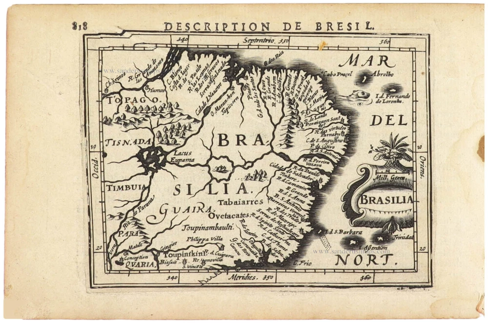
Brazil by Langenes, published by Bertius P. 1602

Petrus Bertius (1565-1629)
Petrus Bertius, born at Beveren, Flanders, in 1565, was related to Pieter van den Keere (Kaerius) and Jodocus Hondius. Both famous cartographers were brothers-in-law of Petrus Bertius. As a refugee, he settled in Amsterdam, and after finishing his studies, he became a professor of mathematics and librarian at the University of Leiden. In 1618, he became a cosmographer and historiographer for Louis XIII of France. He lived in Paris, where he died in 1629.
Petrus Bertius's remarkable work ethic is evident in the numerous geographical and theological works he produced. His contributions to the works of Clüver and Herrera further solidified his reputation in geography.
His fame among geographers was established by his text in the pocket atlas Tabularum Geographicarum and by his edition of Ptolemy’s Geographia.
The origin of the Tabularum Geographicum lies in the well-known miniature atlas Caert thresoor, published by Barent Langenes in 1598 in Middelburg. Bertius engraved 169 maps for this small but attractive atlas, sold for the first time in 1599 by Cornelis Claesz in Amsterdam. In 1600, Claesz published the pocket atlas with a Latin text composed by Petrus Bertius. From then on, new editions, often enlarged with new maps, regularly appeared, subsequently published by Cornelis Claesz, Jodocus Hondius, Johannes Janssonius and ultimately, in 1649, by Claes Jansz. Visscher.
Koeman divides this series of pocketbooks into two atlases: The Caert-thresoor, published by Langenes and Claesz., with five editions between 1598 and 1609, and the Tabularum Geographicarum Contractarum by Petrus Bertius with ten editions between 1600 and 1650.
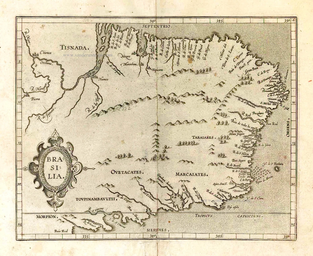
Brasilia.
Item Number: 26537 Authenticity Guarantee
Category: Antique maps > America > South America
Old, antique map of Brazil by Langenes, published by Bertius P.
Date of the first edition: 1598
Date of this map: 1602
Copper engraving
Size: 8.5 x 12.5cm (3.3 x 4.9 inches)
Verso text: Latin
Condition: Excellent.
Condition Rating: A+
References: Van der Krogt 3, 9850:341
From: BERTIUS P. Tabulae Geographicae contractae, ... Amsterdam, C. Claesz., 1602/03.
Petrus Bertius (1565-1629)
Petrus Bertius, born at Beveren, Flanders, in 1565, was related to Pieter van den Keere (Kaerius) and Jodocus Hondius. Both famous cartographers were brothers-in-law of Petrus Bertius. As a refugee, he settled in Amsterdam, and after finishing his studies, he became a professor of mathematics and librarian at the University of Leiden. In 1618, he became a cosmographer and historiographer for Louis XIII of France. He lived in Paris, where he died in 1629.
Petrus Bertius's remarkable work ethic is evident in the numerous geographical and theological works he produced. His contributions to the works of Clüver and Herrera further solidified his reputation in geography.
His fame among geographers was established by his text in the pocket atlas Tabularum Geographicarum and by his edition of Ptolemy’s Geographia.
The origin of the Tabularum Geographicum lies in the well-known miniature atlas Caert thresoor, published by Barent Langenes in 1598 in Middelburg. Bertius engraved 169 maps for this small but attractive atlas, sold for the first time in 1599 by Cornelis Claesz in Amsterdam. In 1600, Claesz published the pocket atlas with a Latin text composed by Petrus Bertius. From then on, new editions, often enlarged with new maps, regularly appeared, subsequently published by Cornelis Claesz, Jodocus Hondius, Johannes Janssonius and ultimately, in 1649, by Claes Jansz. Visscher.
Koeman divides this series of pocketbooks into two atlases: The Caert-thresoor, published by Langenes and Claesz., with five editions between 1598 and 1609, and the Tabularum Geographicarum Contractarum by Petrus Bertius with ten editions between 1600 and 1650.
Related items
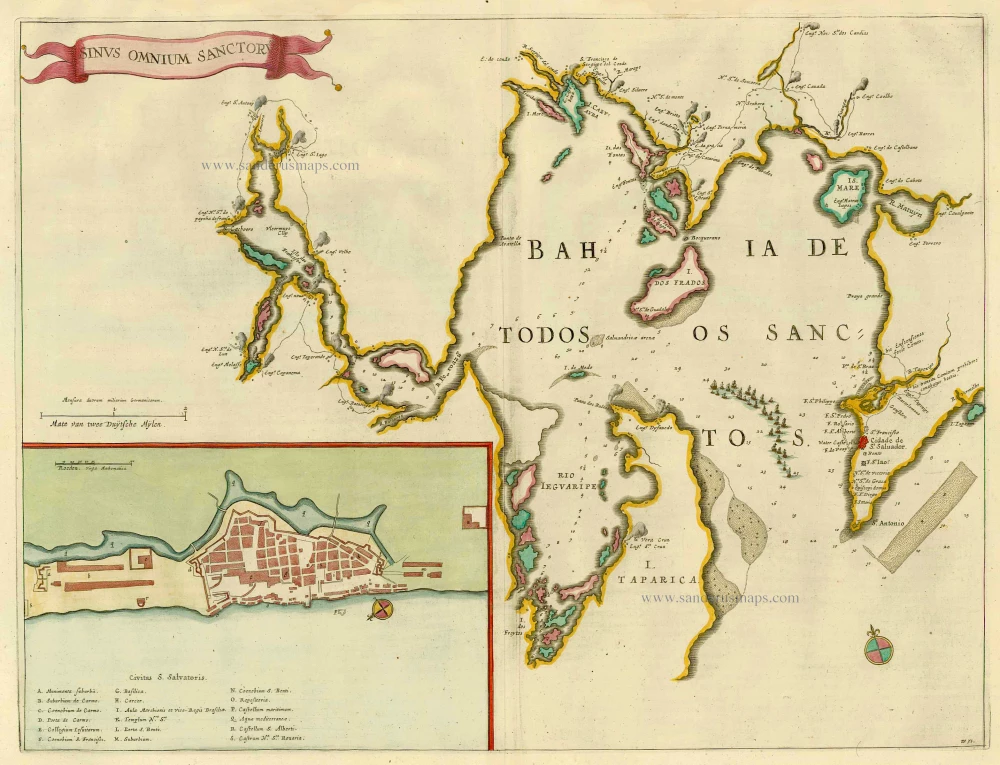
Sinus Omnium Sanctoru. 1664-65
Bahia de Todos los Sanctos, by J. Blaeu.
[Item number: 21226]
Important map in excellent condition
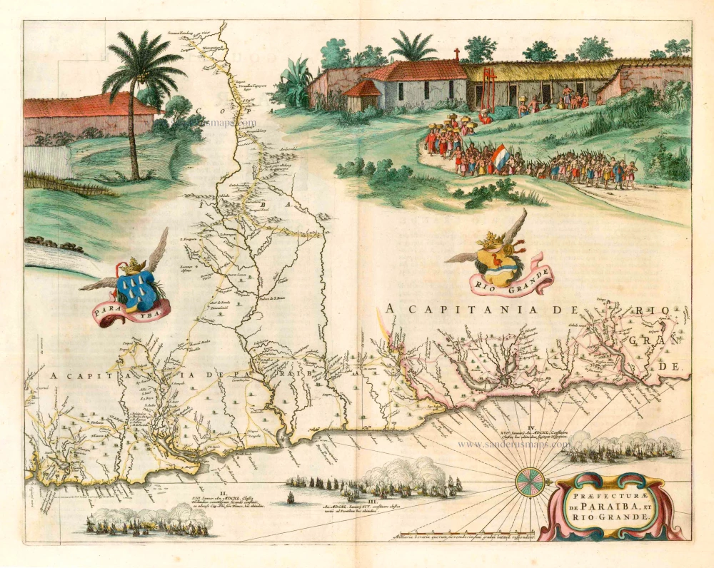
Praefecturae de Paraiba, et Rio Grande. 1663
Brazil - Paraiba, by Joan Blaeu.
[Item number: 25258]

Provincia de Brasil cum Adiacentibus Provinciis. 1630
Brazil, by Johannes de Laet.
[Item number: 25390]

Brasil. 1563
Brazil, by Ramusio G.B.
[Item number: 26186]
Brasilia. 1607
Brazil, by C. van Wytfliet.
[Item number: 26509]

Brasil Nuova Tavola. 1598
Brazil by Girolamo Ruscelli.
[Item number: 28430]

Brasilia. 1645
Brazil, by Joan Blaeu.
[Item number: 29707]
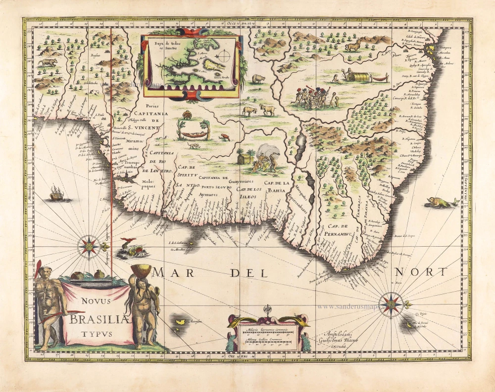
Novus Brasiliae Typus. c. 1640
Brazil, by Willem Blaeu.
[Item number: 29848]
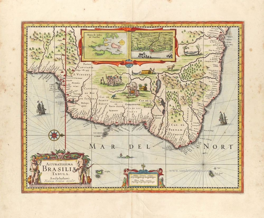
Accuratissima Brasiliae Tabula. 1638
Brazil by Henricus Hondius.
[Item number: 29851]
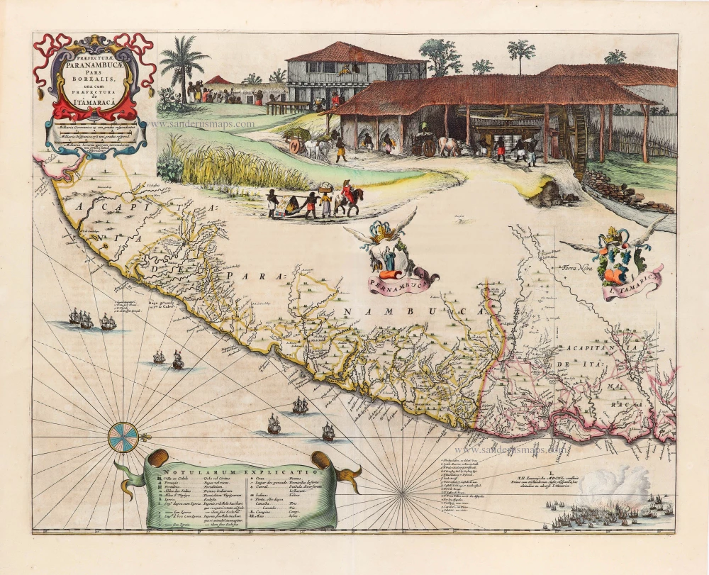
Praefecturae Paranambucae, pars Borealis, una cum Praefectura de Itâmarcâ. 1663
Brazil - Pernambuco (North) by Joan Blaeu.
[Item number: 30149]

Unrecorded view of Pernambuco (Brazil) by Carel Allard
Paranbuca. 1673
View of Pernambuco (Brazil) by Carel Allard.
[Item number: 30558]

Portugalliae et Algarbiae cumfinitimis Hispaniae Regnis: Castiliae, Legionis, Andalusiae, Extrematurae, Galliciae & Granatae Novissima Tabula c. 1720
Portugal & Brazil, by J.B. Homann.
[Item number: 32161]

Rio Iavero 1631
Rio De Janeiro by de Bry Theodore, published by J.L. Gottfried.
[Item number: 32443]

The Fleet of Joris van Spilbergen reaching Brazil
St Vincent 1631
Sao Vicente, by de Bry Theodore, published by J.L. Gottfried.
[Item number: 32444]
Brasilia. 1618
Brazil by Petrus Bertius.
[Item number: 33184]
new