
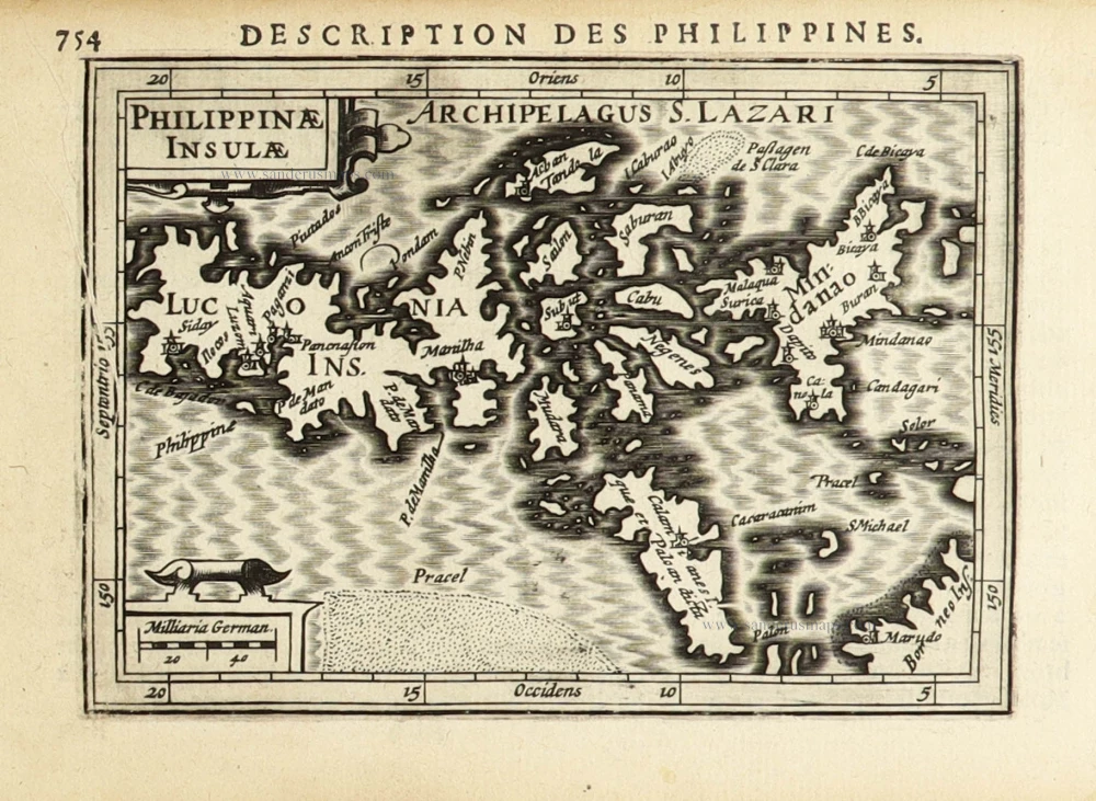
First printed map of the Philippines.
Philippines by Langenes Barent 1600

Petrus Bertius (1565-1629)
Petrus Bertius, born at Beveren, Flanders, in 1565, was related to Pieter van den Keere (Kaerius) and Jodocus Hondius. Both famous cartographers were brothers-in-law of Petrus Bertius. As a refugee, he settled in Amsterdam, and after finishing his studies, he became a professor of mathematics and librarian at the University of Leiden. In 1618, he became a cosmographer and historiographer for Louis XIII of France. He lived in Paris, where he died in 1629.
Petrus Bertius's remarkable work ethic is evident in the numerous geographical and theological works he produced. His contributions to the works of Clüver and Herrera further solidified his reputation in geography.
His fame among geographers was established by his text in the pocket atlas Tabularum Geographicarum and by his edition of Ptolemy’s Geographia.
The origin of the Tabularum Geographicum lies in the well-known miniature atlas Caert thresoor, published by Barent Langenes in 1598 in Middelburg. Bertius engraved 169 maps for this small but attractive atlas, sold for the first time in 1599 by Cornelis Claesz in Amsterdam. In 1600, Claesz published the pocket atlas with a Latin text composed by Petrus Bertius. From then on, new editions, often enlarged with new maps, regularly appeared, subsequently published by Cornelis Claesz, Jodocus Hondius, Johannes Janssonius and ultimately, in 1649, by Claes Jansz. Visscher.
Koeman divides this series of pocketbooks into two atlases: The Caert-thresoor, published by Langenes and Claesz., with five editions between 1598 and 1609, and the Tabularum Geographicarum Contractarum by Petrus Bertius with ten editions between 1600 and 1650.
The Caert-Thresoor.
The Caert-Thresoor of 1598 set a new standard for minor atlases. Scholars like Petrus Bertius and Jacobus Viverius edited the text. The small maps are exceptionally well engraved, neat, clear, and elegantly composed. They served many purposes in other books published in Amsterdam. Their contents reflect the level of cartography in Amsterdam at the turn of the century, where up-to-date information on newly discovered regions was readily available. The Caert-Thresoor is a collection of maps to which the text was adapted and not the other way around, as is the case with many geographical studies.
The first edition was published in 1598 by Barent Langenes, a bookseller and publisher in Middelburg.
The book was reissued under the title P. Bertii Tabularum Geographicarum Libri quatuor, in 1600. Bertius recomposed the contents, following Ptolemy's arrangement. Secondly, in 1609, Jacobus Viverius wrote an entirely revised Dutch text, published under the title Handboeck of Cort Begrijp des Caerten. In or after 1609, the year of Cornelis Claesz.'s death, a French edition appeared, printed by Matthaeus Becker for Hendrik Laurensz., the successor of Cornelis Claesz. Finally, an entirely new small atlas was created in 1616 by Jodocus Hondius Jr. All the maps were re-made, and the text by Bertius was revised.
The original maps from the Caert-Thresoor were used to illustrate many of the books on voyages and geography published in Amsterdam in 1596-1600. (Van der Krogt)
Insulae Philippinae.
Item Number: 32282 Authenticity Guarantee
Category: Antique maps > Asia > Southeast Asia
Philippines by Langenes Barent.
Title: Insulae Philippinae.
Oriented to the east.
Date of the first edition: 1598.
Date of this map: 1600.
Copper engraving, printed on paper.
Image size: 90 x 125mm (3½ x 5 inches).
Sheet size: 110 x 175mm (4¼ x 7 inches).
Verso: French text.
Condition: Excellent.
Condition Rating: A+.
From: Barent Langenes. Thrésor de Chartes. Den Haag, Albert Henry for Cornelis Claesz., c. 1600. (Van der Krogt 3, 341:11)
Petrus Bertius (1565-1629)
Petrus Bertius, born at Beveren, Flanders, in 1565, was related to Pieter van den Keere (Kaerius) and Jodocus Hondius. Both famous cartographers were brothers-in-law of Petrus Bertius. As a refugee, he settled in Amsterdam, and after finishing his studies, he became a professor of mathematics and librarian at the University of Leiden. In 1618, he became a cosmographer and historiographer for Louis XIII of France. He lived in Paris, where he died in 1629.
Petrus Bertius's remarkable work ethic is evident in the numerous geographical and theological works he produced. His contributions to the works of Clüver and Herrera further solidified his reputation in geography.
His fame among geographers was established by his text in the pocket atlas Tabularum Geographicarum and by his edition of Ptolemy’s Geographia.
The origin of the Tabularum Geographicum lies in the well-known miniature atlas Caert thresoor, published by Barent Langenes in 1598 in Middelburg. Bertius engraved 169 maps for this small but attractive atlas, sold for the first time in 1599 by Cornelis Claesz in Amsterdam. In 1600, Claesz published the pocket atlas with a Latin text composed by Petrus Bertius. From then on, new editions, often enlarged with new maps, regularly appeared, subsequently published by Cornelis Claesz, Jodocus Hondius, Johannes Janssonius and ultimately, in 1649, by Claes Jansz. Visscher.
Koeman divides this series of pocketbooks into two atlases: The Caert-thresoor, published by Langenes and Claesz., with five editions between 1598 and 1609, and the Tabularum Geographicarum Contractarum by Petrus Bertius with ten editions between 1600 and 1650.
The Caert-Thresoor.
The Caert-Thresoor of 1598 set a new standard for minor atlases. Scholars like Petrus Bertius and Jacobus Viverius edited the text. The small maps are exceptionally well engraved, neat, clear, and elegantly composed. They served many purposes in other books published in Amsterdam. Their contents reflect the level of cartography in Amsterdam at the turn of the century, where up-to-date information on newly discovered regions was readily available. The Caert-Thresoor is a collection of maps to which the text was adapted and not the other way around, as is the case with many geographical studies.
The first edition was published in 1598 by Barent Langenes, a bookseller and publisher in Middelburg.
The book was reissued under the title P. Bertii Tabularum Geographicarum Libri quatuor, in 1600. Bertius recomposed the contents, following Ptolemy's arrangement. Secondly, in 1609, Jacobus Viverius wrote an entirely revised Dutch text, published under the title Handboeck of Cort Begrijp des Caerten. In or after 1609, the year of Cornelis Claesz.'s death, a French edition appeared, printed by Matthaeus Becker for Hendrik Laurensz., the successor of Cornelis Claesz. Finally, an entirely new small atlas was created in 1616 by Jodocus Hondius Jr. All the maps were re-made, and the text by Bertius was revised.
The original maps from the Caert-Thresoor were used to illustrate many of the books on voyages and geography published in Amsterdam in 1596-1600. (Van der Krogt)
Related items

Carte du Canal des Iles Philippines par lequel Passe le Galion de Manille et les Iles Voisines de ce Canal. 1749
Philippines by Bonne Rigobert
[Item number: 26611]
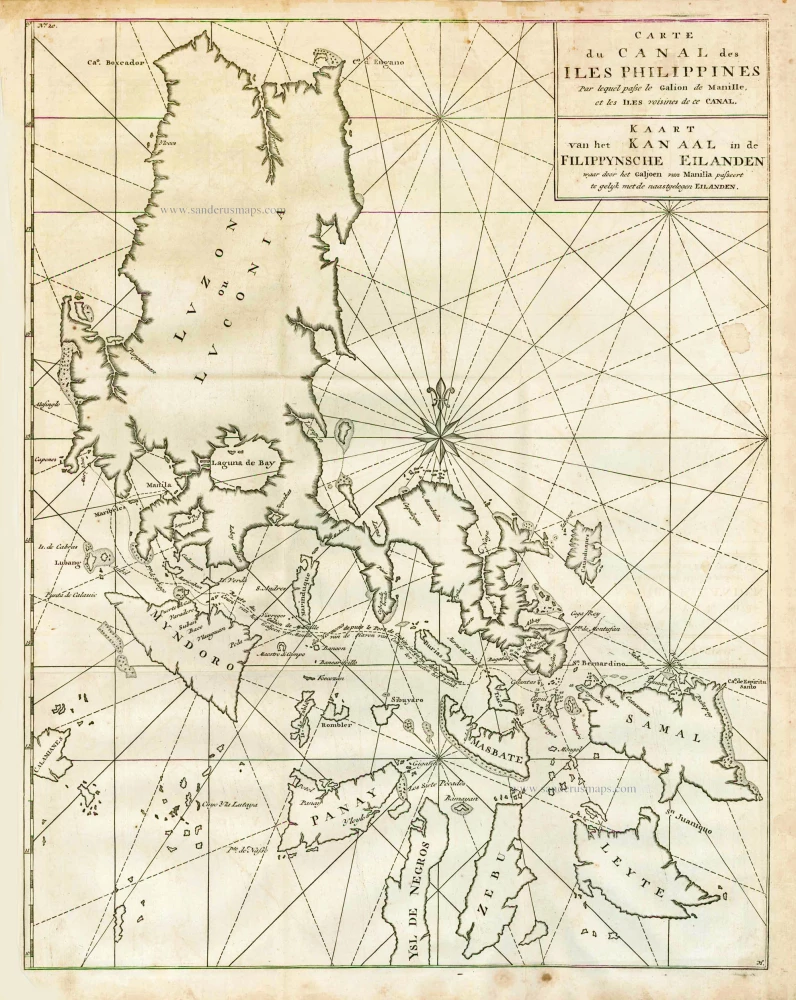
Carte du Canal des Iles Philippines par lequel Passe le Galion de Manille et les Iles Voisines de ce Canal. - Kaart van het Kanaal in de Filippynsche Eilanden waar door het Galjoen van Manilla passeert, tegelijk met de naast gelegen Eilanden. 1748
The Philippines, by George Anson.
[Item number: 27036]
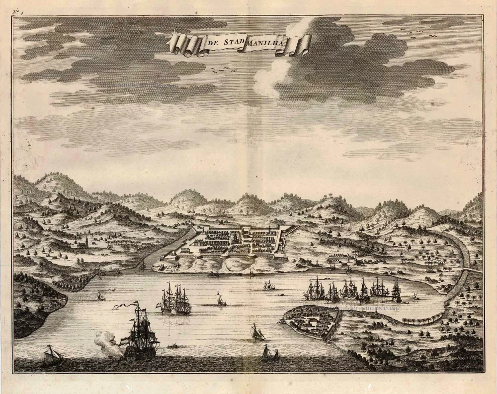
De Stad Manilha. 1726
Philippines - Manilla by François Valentyn (Valentijn)
[Item number: 27894]

Lucon of Luconia. 1726
Philippines, by Valentyn François
[Item number: 27895]

Typus Freti Manilensis. - Détroit de Manilles. 1725
Philippines - Manila Strait by René Augustin Constantin de Renneville.
[Item number: 28370]
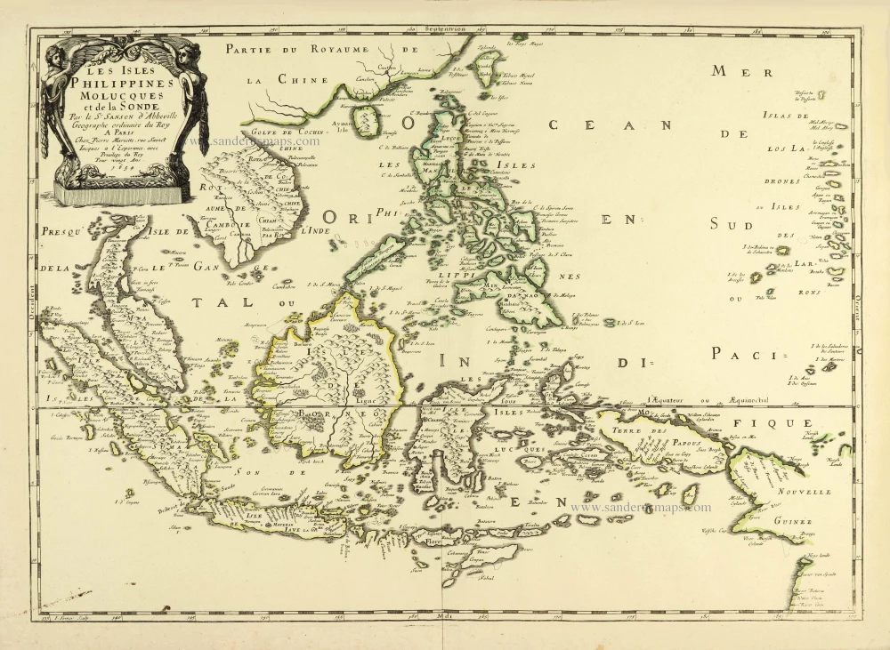
Les Isles Philippines Molucques et de la Sonde. 1658
Southeast Asia par Nicolas Sanson.
[Item number: 28378]
Rare
[No title] - 'Mar di India'. 1645
East Indies by van Spilbergen Joris.
[Item number: 30057]
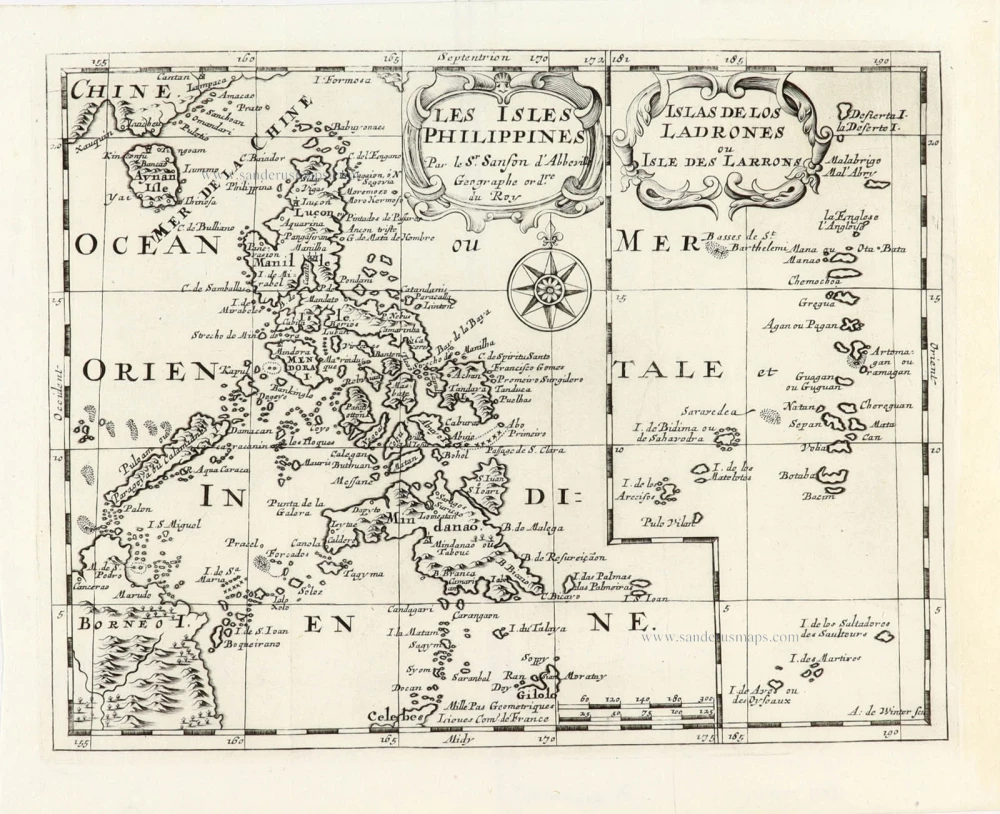
Les Isles Philippines [on sheet with] Islas de los Ladrones ou Isle des Larrons. 1747-74
Philippines, by Nicolas Sanson, published by Prevost d'Exiles.
[Item number: 30304]
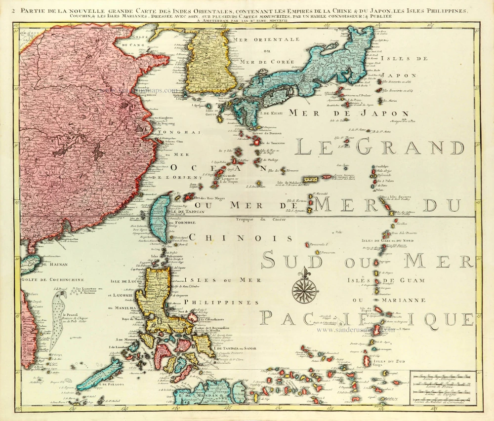
Partie de la Nouvelle Grande Carte des Indes Orientales Contenant les Empires de la Chine, du Japon, les Isles Philippines, Couchin, & les Isles Marianes, 1792
East Asia (Japan - Philippines) by J.B. Elwe.
[Item number: 31803]

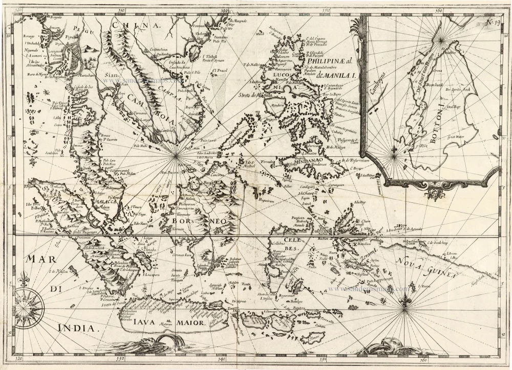
Carte des Isles Philippines Celebes et Moluqes. 1747
Philippines, Moluccas, Borneo, and Sulawesi after J.N. Bellin, published by A.F. Prévost.
[Item number: 31881]
Scarce and important map
Philippinae Insulae. 1618
Philippines by Petrus Bertius.
[Item number: 32158]

Rare
Manual del viajero en Filipinas. 1875
Philippines, travel book by Ramon Gonzalez Fernandez & Federico Moreno y Jeréz
[Item number: 32605]