
Southeast Asia, by Emanuel Bowen. 1747

Emanuel Bowen (c. 1693/94 – 1767)
Emanuel Bowen was an accomplished engraver who became a leading mid-century map and atlas-maker, engraving many maps for contemporary magazines and books. He achieved the unique distinction of becoming Royal Mapmaker to King George II of Great Britain and Louis XV of France.
The earliest work associated with Bowen, the Britannia Depicta (1720), is essentially a strip road atlas based on Ogilby’s maps, with a set of small county maps. Bowen’s co-publisher was Thomas Bowles, and the antiquary who compiled and edited the text was John Owen. The maps are, therefore, sometimes known as ‘Owen-Bowens’.
By 1726 he was noted as one of the leading London engravers. He published A Complete System of Geography, 1744–47; an English Atlas, with a new set of maps, 1745; a Complete Atlas ... in sixty-eight Maps, 1752; Atlas Minimus, 1758; and a series of separate maps of the English counties, of Germany, Asia Minor, and Persia, between 1736 and 1776.
He died in poverty in 1767. His son, Thomas Bowen (1733-1790) would carry on the business until he died in 1790.
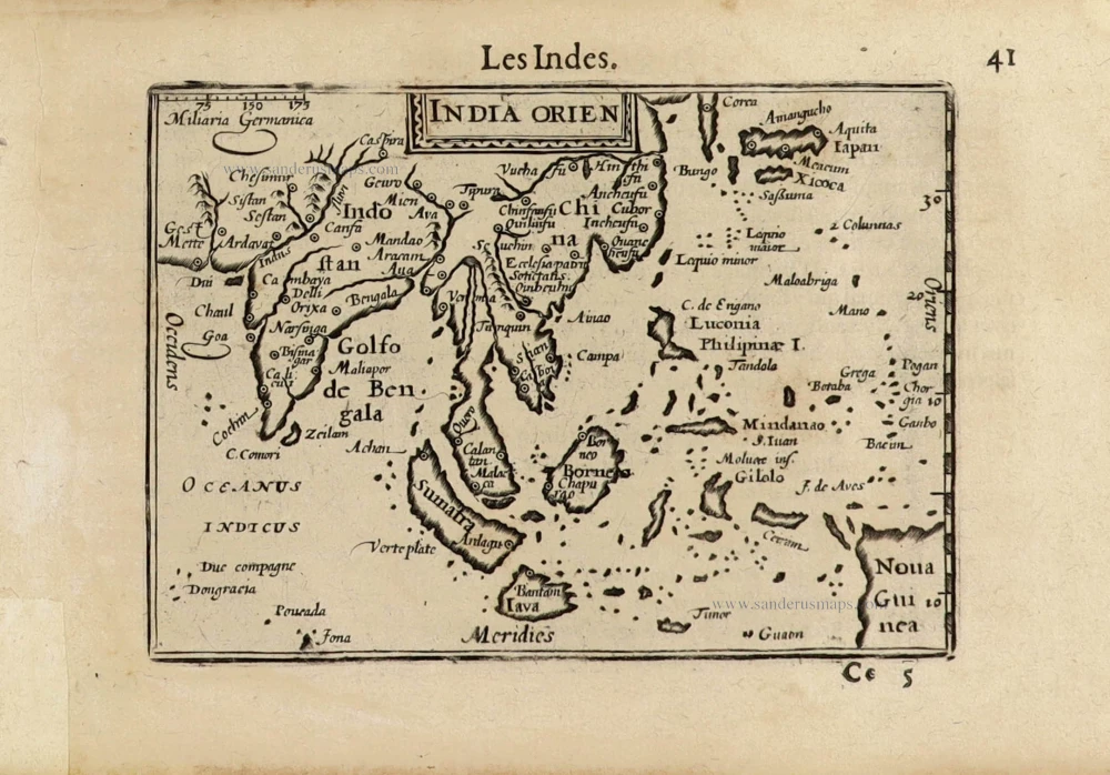
A New and Accurate Map of the East India Islands.
Item Number: 28012 Authenticity Guarantee
Category: Antique maps > Asia > Southeast Asia
Old, antique map of Southeast Asia, by Emanuel Bowen.
Title: A New and Accurate Map of the East India Islands.
Laid down according to the latest discoveries, and agreeable to the most approved Maps & Charts.
The whole being regulated by Astronl Observations.
By Eman Bowen.
Date of the first edition: 1747.
Date of this map: 1747.
Copper engraving, printed on paper.
Size (not including margins): 345 x 425mm (13.58 x 16.73 inches).
Verso: Blank.
Condition: Folds as issued, tear in left margin running 6 cm into the image (reinforced).
Condition Rating: B+.
References: Shirley (Brit.Lib.), T.BOW-2a, #44
From: A complete system of geography. Being a description of all the countries, islands, cities, chief towns, harbours, lakes, and rivers, mountains, mines, &c. of the known world ... In two volumes. The whole illustrated with seventy maps, by Emanuel Bowen, Geographer to His Majesty, being all new-drawn and ingraved according to the latest discoveries and surveys; making, of themselves, a complete atlas, for the sse of gentlemen, merchants, mariners, and others, who delight in history and geography ... London, 1747.
Emanuel Bowen (c. 1693/94 – 1767)
Emanuel Bowen was an accomplished engraver who became a leading mid-century map and atlas-maker, engraving many maps for contemporary magazines and books. He achieved the unique distinction of becoming Royal Mapmaker to King George II of Great Britain and Louis XV of France.
The earliest work associated with Bowen, the Britannia Depicta (1720), is essentially a strip road atlas based on Ogilby’s maps, with a set of small county maps. Bowen’s co-publisher was Thomas Bowles, and the antiquary who compiled and edited the text was John Owen. The maps are, therefore, sometimes known as ‘Owen-Bowens’.
By 1726 he was noted as one of the leading London engravers. He published A Complete System of Geography, 1744–47; an English Atlas, with a new set of maps, 1745; a Complete Atlas ... in sixty-eight Maps, 1752; Atlas Minimus, 1758; and a series of separate maps of the English counties, of Germany, Asia Minor, and Persia, between 1736 and 1776.
He died in poverty in 1767. His son, Thomas Bowen (1733-1790) would carry on the business until he died in 1790.
Related items

Archipel des Indes Orientales qui Comprend les Isles de la Sonde, Moluques et Philippines. c. 1757
Southeast Asia, par Robert de Vaugondy.
[Item number: 4751]

The most accurate and one of the most elegant 17th c. maps of the East Indies
Indiae Orientalis Nova Descriptio. 1644-58
Southeast Asia by Janssonius, Johannes
[Item number: 10013]

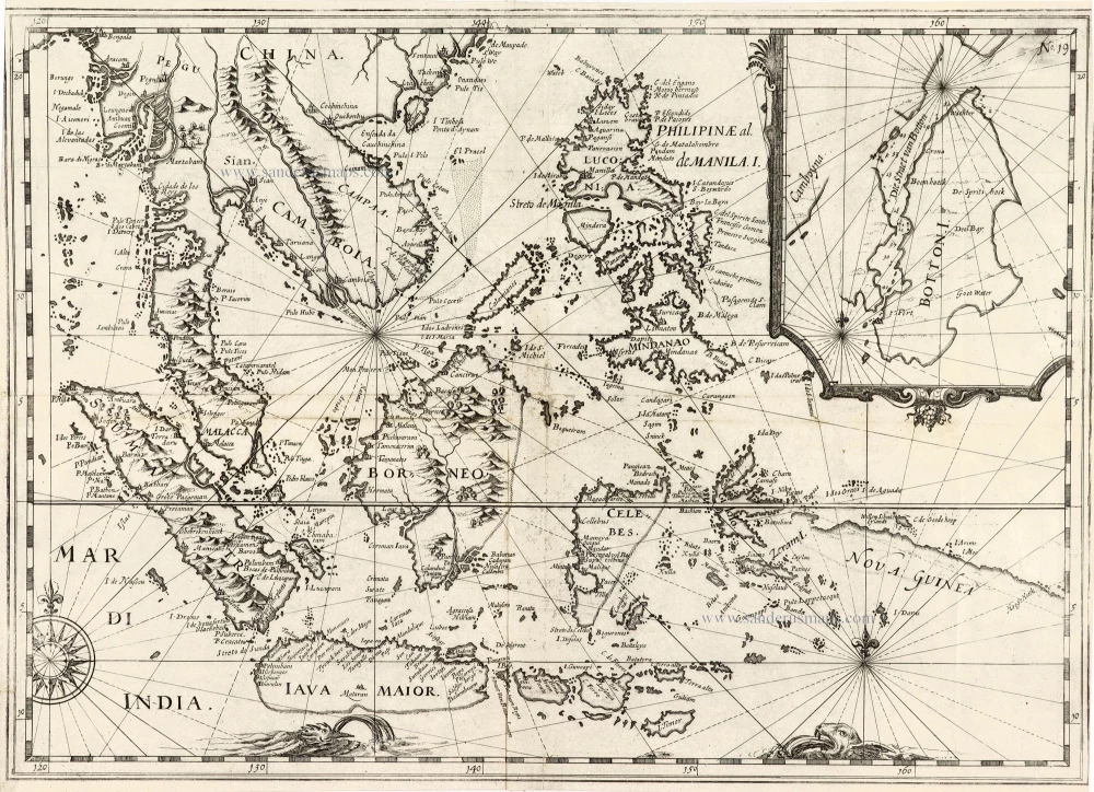
India Orientalis. 1607
Southeast Asia, by G. Mercator - J. Hondius (small)
[Item number: 25186]

From the Cloppenburg edition
Insulae Indiae Orientalis. 1630
Southeast Asia, by G. Mercator - J. Hondius.
[Item number: 25234]

Le Royaume de Siam avec les Royaumes qui luy sont Tributaires, et les Isles de Sumatra, Andemaon, etc. et les Isles Voisine. c. 1700
Southeast Asia, by J. Ottens.
[Item number: 25716]

Indiae Orientalis nec non Insularum Adiacentium Nova Descriptio. c. 1740
Southeast Asia by Nicolaes Visscher, published by Petrus Schenk.
[Item number: 25718]
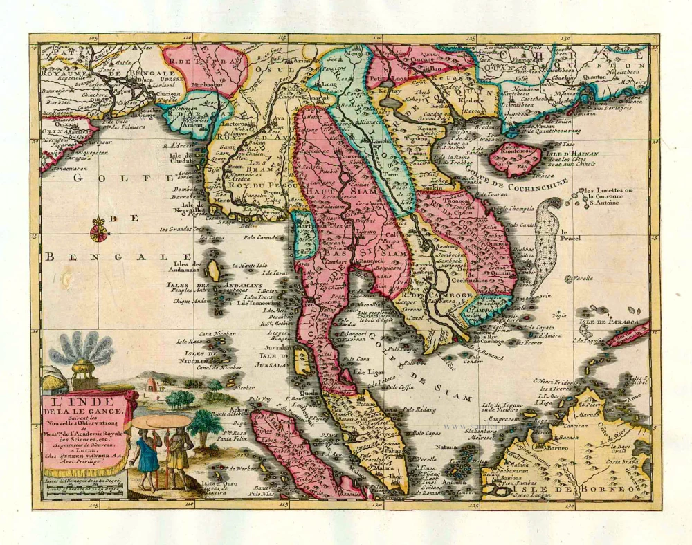
L'Inde de la le Gange, 1713
Southeast Asia, by Pieter van der Aa.
[Item number: 26097]

India Orientalis. 1597
Southeast Asia, by Giovanni Magini.
[Item number: 26521]
This map has the first accurate depiction of the Philippines
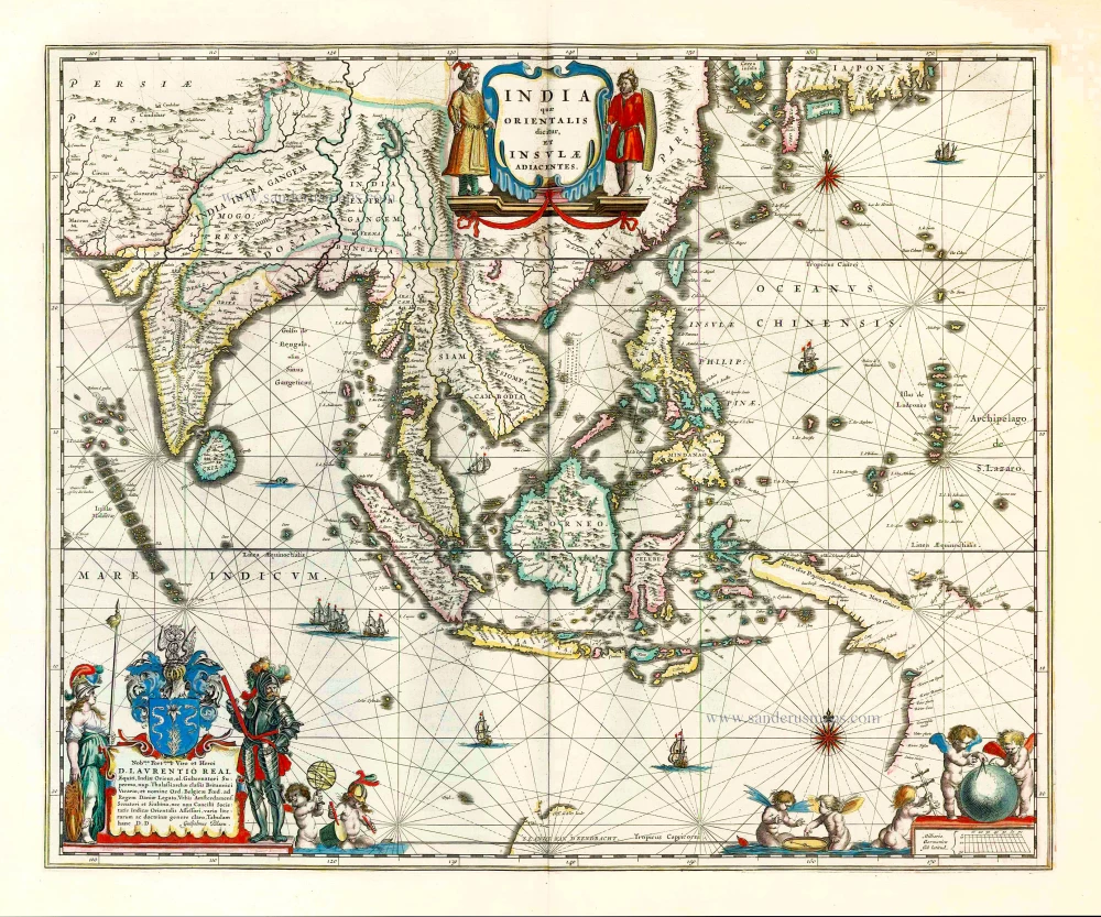
India quae Orientalis dicitur et Insulae Adiacentes. 1640-43
Southeast Asia by Willem & Joan Blaeu
[Item number: 26566]

Archipel des Indes Orientales qui comprend les Isles de la Sonde, Moluques et Philippines. 1776-79
Southeast Asia, by Francesco Santini.
[Item number: 26977]

Seconde Partie de la Carte d'Asie Contenant la Chine et Partie de la Tartarie, l'Inde au Deca du Gange, les Isles Sumatra, Java, Borneo, Moluques, Philippines, et du Japo 1746-53
Southeast Asia, by J.B. d'Anville.
[Item number: 27401]

Suite de L'Ocean Oriental Contenant Les Isles de la Sonde Les Costes de Tunquin et de la Chine Les Isles du Japon les Philippines Moluques. 1747
Southeast Asia by Jacques Nicolas Bellin.
[Item number: 28189]

Carte des Indes en deçà et au dela du Gange; avec les Isles de la Sonde, Borneo, les Moluques et les Philippines. Partie Orientale. 1690
Southeast Asia by Rigobert Bonne.
[Item number: 28304]

Scarce
Tabula Asiae XI. 1548
Southeast Asia by Giacomo Gastaldi / Ptolemy.
[Item number: 28362]

Penisola Dell India di la dal Gange Divisa ne i Regni, che in essasi contengono et accresciuta di varie notizie. 1692
Indochina by Cantelli da Vignola, published by Giovanni Giacomo de Rossi.
[Item number: 28371]

Indiae Orientalis nec non Insularum Adiacentium Nova Descriptio. 1678
Southeast Asia by Nicolaes Visscher I.
[Item number: 28555]

Le Royaume de Siam avec les Royaumes qui luy sont Tributaires et les Isles de Sumatra Andemaon etc. et les isles voisines. 1719
Antique map of Southeast Asia by Châtelain
[Item number: 29372]
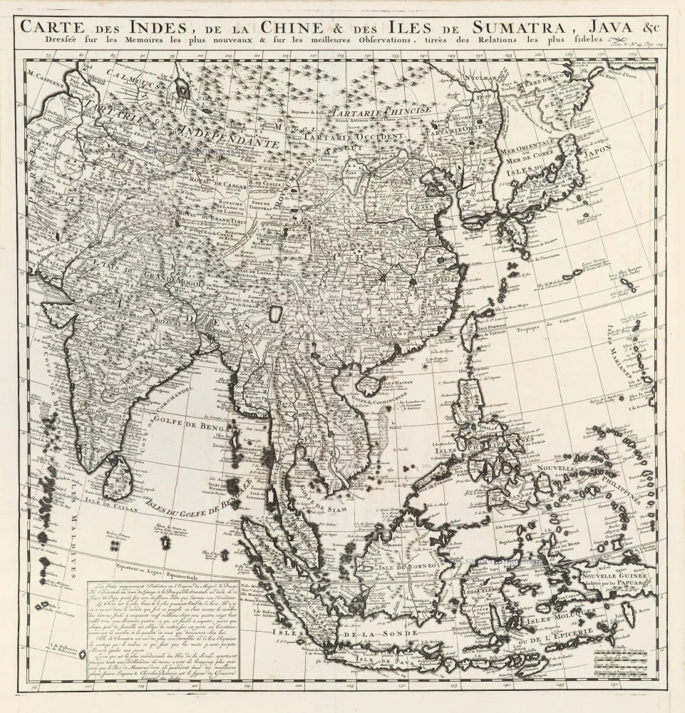
Carte des Indes, de la Chine & des Iles de Sumatra, Java &c. 1719
Southeast Asia, by Z. Châtelain.
[Item number: 29376]
Rare
[No title] - 'Mar di India'. 1645
East Indies by van Spilbergen Joris.
[Item number: 30057]

Two early modern maps of Southeast Asia by L. Fries and M. Waldseemüller
Tabu. Moder. Indiae [together with] India Orien talis. 1535
South Asia by Lorens Fries
[Item number: 30141]

Very rare first 1570 A edition.
Indiae Orientalis Insularumque Adiacientium Typus. 1570
Southeast Asia, by Abraham Ortelius.
[Item number: 30592]
India Orien. c. 1600
Southeast Asia by Barent Langenes.
[Item number: 32298]

Scarce
Zee-togt van Alfonso d'Albuquerque na de Roode Zee, d'Arabize en Persize kusten, met die van Ormus, Guzaratte, Goa, Malacca en Verder Indien tot aan't Eiland Iava. 1707
Indian Ocean & Southeast Asia by Pieter Van der Aa.
[Item number: 32321]

Scarce
De Kusten van Guzaratte, Malabar, Bengale en Malacca met die van't Magtig Koninkryk Siam, tot aan China bestevend. 1707
Indian Ocean, India, Thailand, and Siam by Pieter Van der Aa.
[Item number: 32323]