
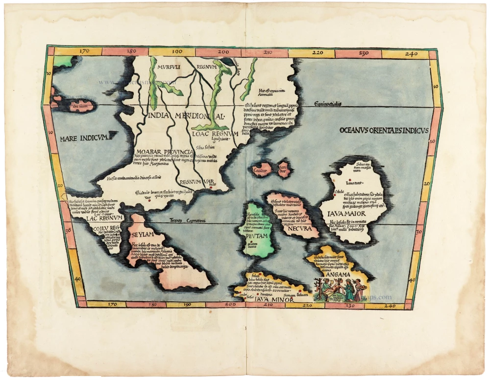
Southeast Asia, by J.B. d'Anville. 1746-53

Nicolas de Fer (1646-1720)
Nicolas de Fer was one of the greatest map producers of the 17th century. At the age of twelve, he had been apprenticed to the etcher Louis Spirinx in Paris. He quickly turned to the actual making of geography maps and edited very current and "useful" documents: border maps, towns fortified by Vauban, voyages of discovery, etc.
His father, Antoine de Fer, a modest print merchant, died in June 1673. His widow, Geneviève Hourlier, continued to operate the fund during the years following the death of her husband.
The career of Nicolas de Fer did not begin until 1687, when his mother gave up her business in maps. After several difficult years, he achieved high prosperity and notoriety. He was appointed as a geographer of the Grand Dauphin and published his first atlases, the Côtes de France and the Introduction à la fortification.
When the Grand Dauphin died in 1711, he became "Géographe des rois de France et d'Espagne" (Geographer of the kings of France and Spain). After the disappearance of Louis XIV, we found him, in 1720, with the sole title of "Géographe ordinaire de Sa Majesté Catholique".
At the time that he received this official support, N. de Fer continued to publish atlases which, both by their number and by the importance of their content, significantly contributed to the success of his publishing career. He published numerous successful atlases and other works. Dutch publishers copied several of these atlases. In 1695 Pieter Mortier published the Atlas Royal, and Carel Allard published the Théatre de la Guerre du Pais Bas Catholique in the following years. He also published 26 large wall maps.
The sign of De Fer's shop was the "Sphère Royale", an emblem to which he was very attached because we find the image of this armillary sphere on many of his publications.
Seconde Partie de la Carte d'Asie Contenant la Chine et Partie de la Tartarie, l'Inde au Deca du Gange, les Isles Sumatra, Java, Borneo, Moluques, Philippines, et du Japo
Item Number: 27401 Authenticity Guarantee
Category: Antique maps > Asia > Southeast Asia
Old, antique map of Southeast Asia, by J.B. d'Anville.
Title: Seconde Partie de la Carte d'Asie Contenant la Chine et Partie de la Tartarie, l'Inde au Deca du Gange, les Isles Sumatra, Java, Borneo, Moluques, Philippines, et du Japo
Cartographer: d'Anville J.B..
Date of the first edition: 1752.
Date of this map: 1746-53.
Copper engraving, printed on paper.
Size (not including margins): 960 x 690mm (37.8 x 27.17 inches).
Verso: Blank.
Condition: Coloured in outline, excellent.
Condition Rating: A+.
From: Atlas ou receil de cartes géographiques, dressées sur les nouvelles observations de Mrs de L'Académie Toyale des Sciences, par N. de Fer. Paris, Desbois, fils post-hume de l'auteur, 1746-[53].
Nicolas de Fer (1646-1720)
Nicolas de Fer was one of the greatest map producers of the 17th century. At the age of twelve, he had been apprenticed to the etcher Louis Spirinx in Paris. He quickly turned to the actual making of geography maps and edited very current and "useful" documents: border maps, towns fortified by Vauban, voyages of discovery, etc.
His father, Antoine de Fer, a modest print merchant, died in June 1673. His widow, Geneviève Hourlier, continued to operate the fund during the years following the death of her husband.
The career of Nicolas de Fer did not begin until 1687, when his mother gave up her business in maps. After several difficult years, he achieved high prosperity and notoriety. He was appointed as a geographer of the Grand Dauphin and published his first atlases, the Côtes de France and the Introduction à la fortification.
When the Grand Dauphin died in 1711, he became "Géographe des rois de France et d'Espagne" (Geographer of the kings of France and Spain). After the disappearance of Louis XIV, we found him, in 1720, with the sole title of "Géographe ordinaire de Sa Majesté Catholique".
At the time that he received this official support, N. de Fer continued to publish atlases which, both by their number and by the importance of their content, significantly contributed to the success of his publishing career. He published numerous successful atlases and other works. Dutch publishers copied several of these atlases. In 1695 Pieter Mortier published the Atlas Royal, and Carel Allard published the Théatre de la Guerre du Pais Bas Catholique in the following years. He also published 26 large wall maps.
The sign of De Fer's shop was the "Sphère Royale", an emblem to which he was very attached because we find the image of this armillary sphere on many of his publications.
Related items

A New and Accurate Map of the East India Islands. 1747
Southeast Asia, by Emanuel Bowen.
[Item number: 28012]

Suite de L'Ocean Oriental Contenant Les Isles de la Sonde Les Costes de Tunquin et de la Chine Les Isles du Japon les Philippines Moluques. 1747
Southeast Asia by Jacques Nicolas Bellin.
[Item number: 28189]

Carte des Indes en deçà et au dela du Gange; avec les Isles de la Sonde, Borneo, les Moluques et les Philippines. Partie Orientale. 1690
Southeast Asia by Rigobert Bonne.
[Item number: 28304]

Scarce
Tabula Asiae XI. 1548
Southeast Asia by Giacomo Gastaldi / Ptolemy.
[Item number: 28362]

Penisola Dell India di la dal Gange Divisa ne i Regni, che in essasi contengono et accresciuta di varie notizie. 1692
Indochina by Cantelli da Vignola, published by Giovanni Giacomo de Rossi.
[Item number: 28371]

Indiae Orientalis nec non Insularum Adiacentium Nova Descriptio. 1678
Southeast Asia by Nicolaes Visscher I.
[Item number: 28555]
In rare original colour.
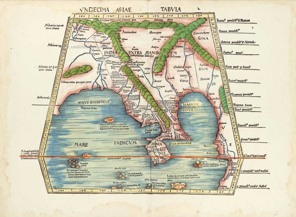
Undecima Asiae Tabula. 1513
South Asia by Waldseemüller Martin
[Item number: 29249]

Le Royaume de Siam avec les Royaumes qui luy sont Tributaires et les Isles de Sumatra Andemaon etc. et les isles voisines. 1719
Antique map of Southeast Asia by Châtelain
[Item number: 29372]
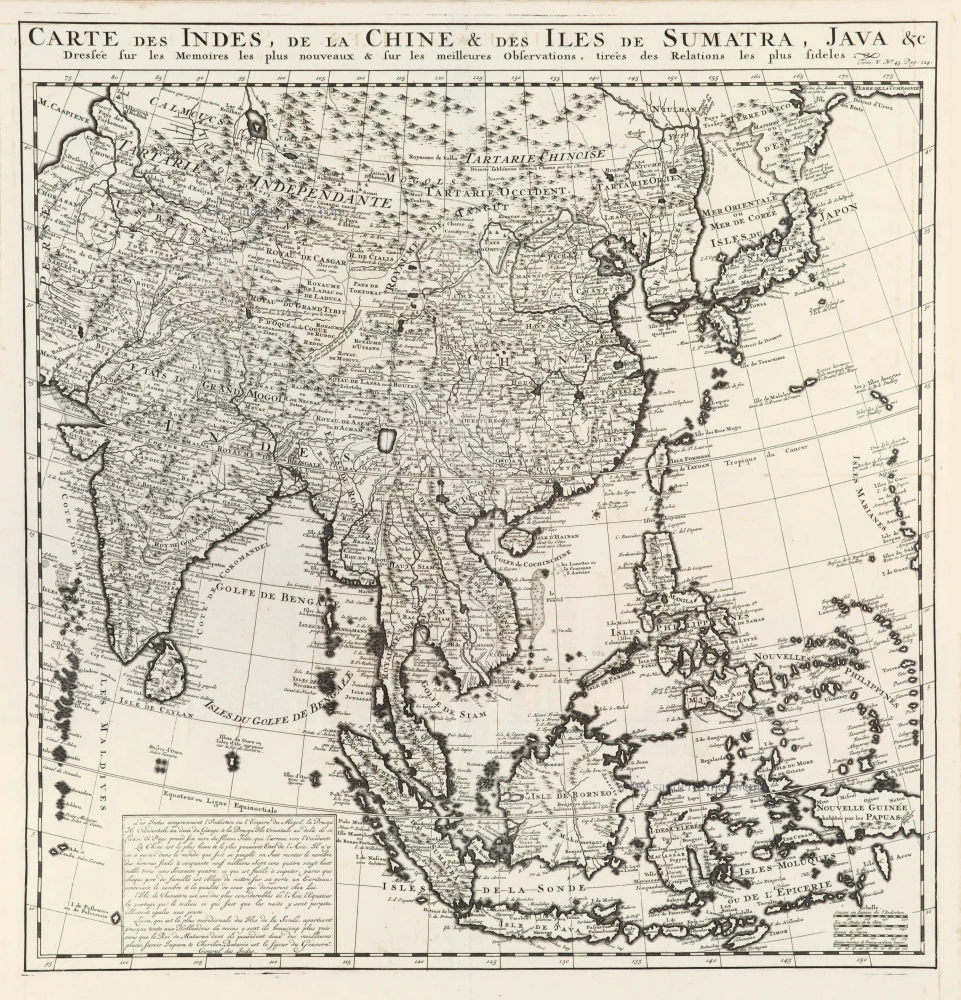
Carte des Indes, de la Chine & des Iles de Sumatra, Java &c. 1719
Southeast Asia, by Z. Châtelain.
[Item number: 29376]

Isole Molucche.- [Above map :] Descrittione del l'Isole Molucche. 1590
Southeast Asia by Tommaso Porcacchi.
[Item number: 29788]
The most elegant and decorative map of the region
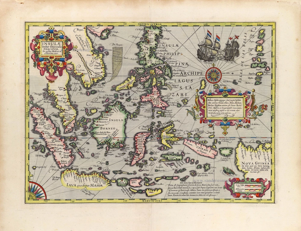
Insulae Indiae Orientalis Praecipuae, in quibus Moluccae celeberrimae sunt. 1630
East Indian Archipelago by Jodocus Hondius.
[Item number: 29863]
Rare
[No title] - 'Mar di India'. 1645
East Indies by van Spilbergen Joris.
[Item number: 30057]

Two early modern maps of Southeast Asia by L. Fries and M. Waldseemüller
Tabu. Moder. Indiae [together with] India Orien talis. 1535
South Asia by Lorens Fries
[Item number: 30141]

Very rare first 1570 A edition.
Indiae Orientalis Insularumque Adiacientium Typus. 1570
Southeast Asia, by Abraham Ortelius.
[Item number: 30592]
Rare 1525 edition in nice old colour.
[No title - on verso:] Tabula Moder. Indiae Orientalis. 1525
Ptolemy map of Southeast Asia by Lorenz Fries, after Martin Waldseemüller.
[Item number: 30658]

Scarce
D'Indize kusten van Bengale, Pegu, Malacca en Siam tot in China, met d'Eylanden Sumatra, Iava, Borneo, Moluccos en andere. [with:] De vaste kusten en eylanden van Indien, van Pegu en Malacca af, tot aan de Moluccos, etc. 1714
Southeast Asia by Pieter Vander Aa, two maps.
[Item number: 31123]
India Orien. c. 1600
Southeast Asia by Barent Langenes.
[Item number: 32298]

Scarce
Zee-togt van Alfonso d'Albuquerque na de Roode Zee, d'Arabize en Persize kusten, met die van Ormus, Guzaratte, Goa, Malacca en Verder Indien tot aan't Eiland Iava. 1707
Indian Ocean & Southeast Asia by Pieter Van der Aa.
[Item number: 32321]

Scarce
De Kusten van Guzaratte, Malabar, Bengale en Malacca met die van't Magtig Koninkryk Siam, tot aan China bestevend. 1707
Indian Ocean, India, Thailand, and Siam by Pieter Van der Aa.
[Item number: 32323]

Beautiful example of this important map
Indiae Orientalis Insularumque Adiacientium Typus. 1587
Southeast Asia, by Abraham Ortelius.
[Item number: 32831]