
Southeast Asia by Tommaso Porcacchi. 1590

Thomaso (Tommaso) Porcacchi (c. 1530-1585)
Thomaso Porcacchi was born in Castiglion Fiorentino (Arentino), Tuscany, into a poor family. Through the patronage of Duke Cosimo I de' Medici, he was able to pursue his studies; afterwards, he embarked on a career as a translator, editor and author, initially in Florence, often working with the humanist scholar Lodovico Domenichi. His speciality was classical texts, particularly of a geographical and historical nature. Through this work, he came into contact with the prominent Venetian publisher Gabriel Giolito de' Ferrari and, in 1559, he moved to Venice to form a fruitful association with Giolito, who had produced several books containing maps.
Later in his career, Porcacchi composed an isolario, L'isole piu famose del mondo ..., published by Simone Galignani de Karera and Girolamo Porro in 1572. In 1574 Porro engraved the plates for another Porcachi volume, Funerali antichi di diversi popoli, et nationi ..., and he later contributed the maps to a new edition of Claudius Prolemy's Geographiae universae tum veteris tum novae ..., edited by Giovanni Antonio Magini and published by the Heirs of Simone Galignani de Karera.
The first edition of Porcacchi's L'isole piu famose contained 30 engraved maps, set in text. The coverage was worldwide, albeit concentrated on the Mediterranean. For the second edition, the text was rewritten, and 17 additional maps were inserted, to make a total of 47.
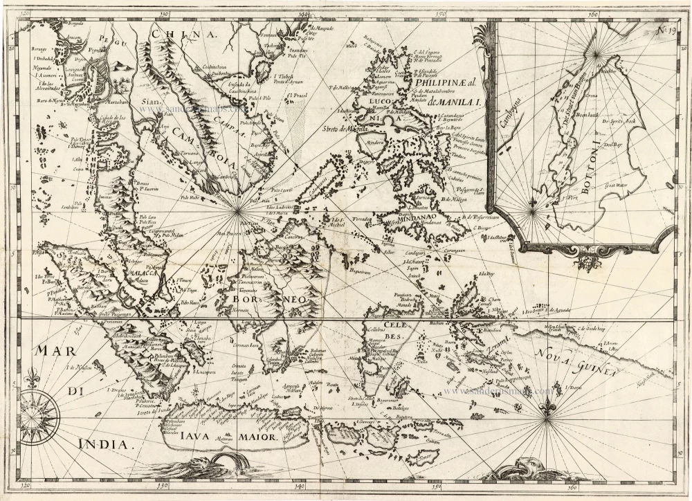
Isole Molucche.- [Above map :] Descrittione del l'Isole Molucche.
Item Number: 29788 Authenticity Guarantee
Category: Antique maps > Asia > Southeast Asia
Old, antique map of Southeast Asia by Tommaso Porcacchi.
Title: Isole Molucche.- [Above map :] Descrittione del l'Isole Molucche.
Engraver: Girolamo Porro.
Date of the first edition: 1572.
Date of this map: 1590.
Copper engraving, printed on paper.
Image size: 105 x 145mm (4.13 x 5.71 inches).
Sheet size: 295 x 195mm (11.61 x 7.68 inches).
Verso: Italian text.
Condition: Excellent.
Condition Rating: A+.
From: Porcacchi T. L'Isole Piu Famose Del Mondo. Venice, Giorgio Angelieri for the Heirs of Simone Galignani, 1590.
Thomaso (Tommaso) Porcacchi (c. 1530-1585)
Thomaso Porcacchi was born in Castiglion Fiorentino (Arentino), Tuscany, into a poor family. Through the patronage of Duke Cosimo I de' Medici, he was able to pursue his studies; afterwards, he embarked on a career as a translator, editor and author, initially in Florence, often working with the humanist scholar Lodovico Domenichi. His speciality was classical texts, particularly of a geographical and historical nature. Through this work, he came into contact with the prominent Venetian publisher Gabriel Giolito de' Ferrari and, in 1559, he moved to Venice to form a fruitful association with Giolito, who had produced several books containing maps.
Later in his career, Porcacchi composed an isolario, L'isole piu famose del mondo ..., published by Simone Galignani de Karera and Girolamo Porro in 1572. In 1574 Porro engraved the plates for another Porcachi volume, Funerali antichi di diversi popoli, et nationi ..., and he later contributed the maps to a new edition of Claudius Prolemy's Geographiae universae tum veteris tum novae ..., edited by Giovanni Antonio Magini and published by the Heirs of Simone Galignani de Karera.
The first edition of Porcacchi's L'isole piu famose contained 30 engraved maps, set in text. The coverage was worldwide, albeit concentrated on the Mediterranean. For the second edition, the text was rewritten, and 17 additional maps were inserted, to make a total of 47.
Related items

The most accurate and one of the most elegant 17th c. maps of the East Indies
Indiae Orientalis Nova Descriptio. 1644-58
Southeast Asia by Janssonius, Johannes
[Item number: 10013]

India Orientalis. 1607
Southeast Asia, by G. Mercator - J. Hondius (small)
[Item number: 25186]

From the Cloppenburg edition
Insulae Indiae Orientalis. 1630
Southeast Asia, by G. Mercator - J. Hondius.
[Item number: 25234]

Le Royaume de Siam avec les Royaumes qui luy sont Tributaires, et les Isles de Sumatra, Andemaon, etc. et les Isles Voisine. c. 1700
Southeast Asia, by J. Ottens.
[Item number: 25716]

Indiae Orientalis nec non Insularum Adiacentium Nova Descriptio. c. 1740
Southeast Asia by Nicolaes Visscher, published by Petrus Schenk.
[Item number: 25718]
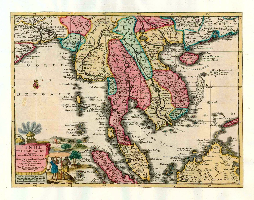
L'Inde de la le Gange, 1713
Southeast Asia, by Pieter van der Aa.
[Item number: 26097]

India Orientalis. 1597
Southeast Asia, by Giovanni Magini.
[Item number: 26521]
This map has the first accurate depiction of the Philippines
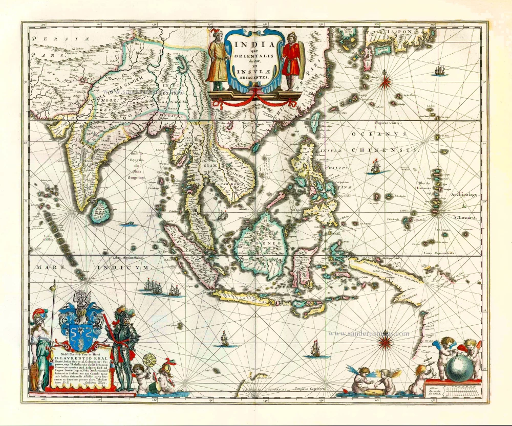
India quae Orientalis dicitur et Insulae Adiacentes. 1640-43
Southeast Asia by Willem & Joan Blaeu
[Item number: 26566]

Archipel des Indes Orientales qui comprend les Isles de la Sonde, Moluques et Philippines. 1776-79
Southeast Asia, by Francesco Santini.
[Item number: 26977]

Seconde Partie de la Carte d'Asie Contenant la Chine et Partie de la Tartarie, l'Inde au Deca du Gange, les Isles Sumatra, Java, Borneo, Moluques, Philippines, et du Japo 1746-53
Southeast Asia, by J.B. d'Anville.
[Item number: 27401]

Suite de L'Ocean Oriental Contenant Les Isles de la Sonde Les Costes de Tunquin et de la Chine Les Isles du Japon les Philippines Moluques. 1747
Southeast Asia by Jacques Nicolas Bellin.
[Item number: 28189]

Carte des Indes en deçà et au dela du Gange; avec les Isles de la Sonde, Borneo, les Moluques et les Philippines. Partie Orientale. 1690
Southeast Asia by Rigobert Bonne.
[Item number: 28304]

Scarce
Tabula Asiae XI. 1548
Southeast Asia by Giacomo Gastaldi / Ptolemy.
[Item number: 28362]

Indiae Orientalis nec non Insularum Adiacentium Nova Descriptio. 1678
Southeast Asia by Nicolaes Visscher I.
[Item number: 28555]

Isole dell'Indie, Divise in Filippine, Molucche, e della Sonda. 1696
Southeast Asia and Northwest Australia by Vincenzo Coronelli.
[Item number: 28670]

Le Royaume de Siam avec les Royaumes qui luy sont Tributaires et les Isles de Sumatra Andemaon etc. et les isles voisines. 1719
Antique map of Southeast Asia by Châtelain
[Item number: 29372]
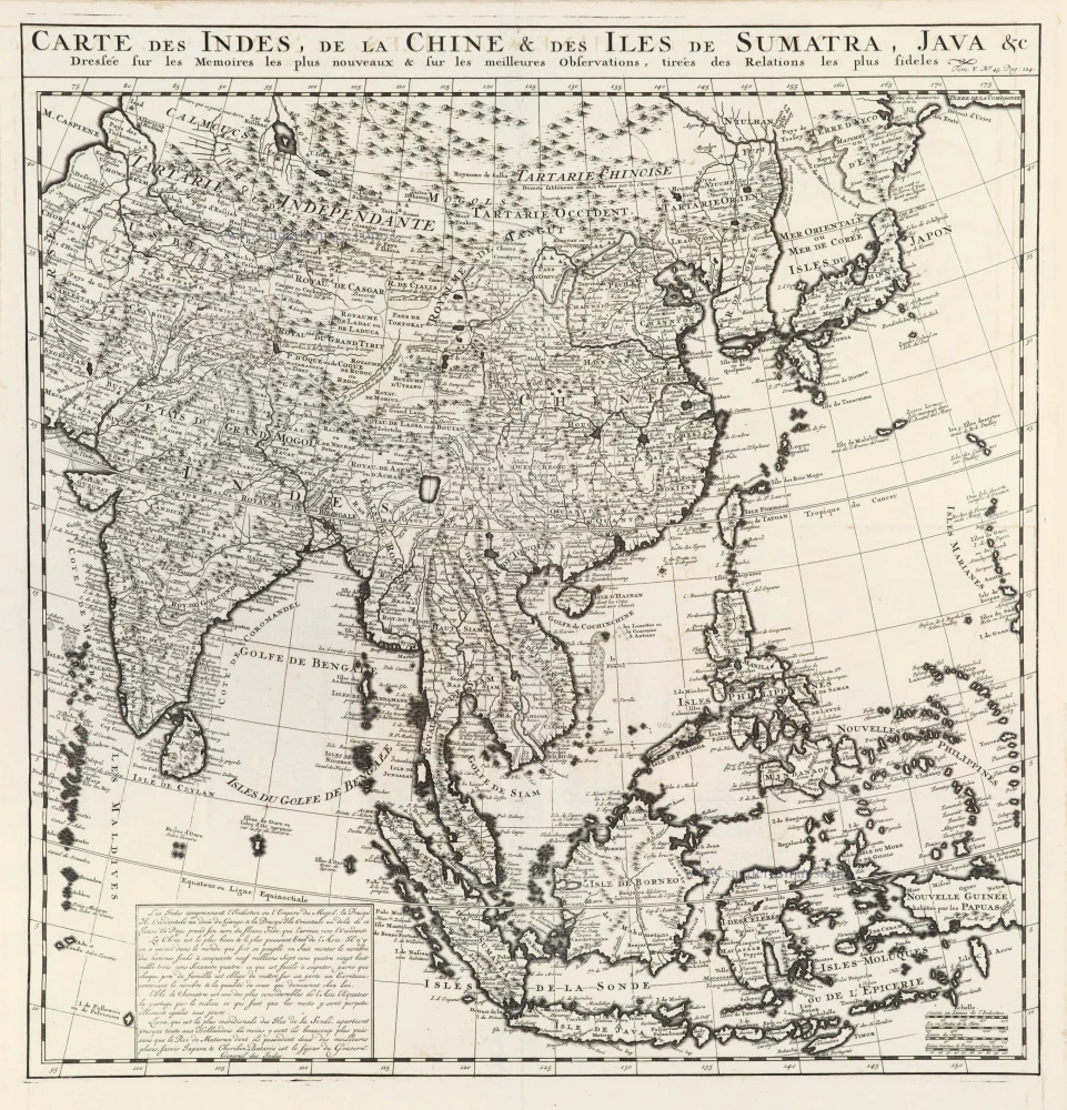
Carte des Indes, de la Chine & des Iles de Sumatra, Java &c. 1719
Southeast Asia, by Z. Châtelain.
[Item number: 29376]
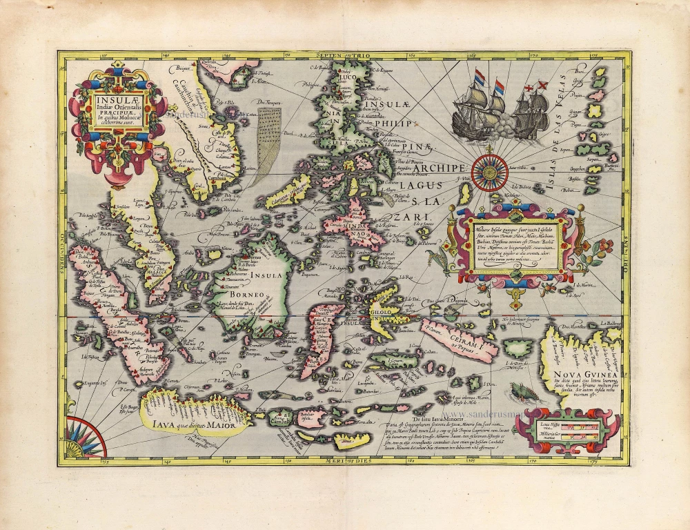
The most elegant and decorative map of the region
Insulae Indiae Orientalis Praecipuae, in quibus Moluccae celeberrimae sunt. 1630
East Indian Archipelago by Jodocus Hondius.
[Item number: 29863]
Rare
[No title] - 'Mar di India'. 1645
East Indies by van Spilbergen Joris.
[Item number: 30057]

Two early modern maps of Southeast Asia by L. Fries and M. Waldseemüller
Tabu. Moder. Indiae [together with] India Orien talis. 1535
South Asia by Lorens Fries
[Item number: 30141]

Very rare first 1570 A edition.
Indiae Orientalis Insularumque Adiacientium Typus. 1570
Southeast Asia, by Abraham Ortelius.
[Item number: 30592]

Scarce
D'Indize kusten van Bengale, Pegu, Malacca en Siam tot in China, met d'Eylanden Sumatra, Iava, Borneo, Moluccos en andere. [with:] De vaste kusten en eylanden van Indien, van Pegu en Malacca af, tot aan de Moluccos, etc. 1714
Southeast Asia by Pieter Vander Aa, two maps.
[Item number: 31123]
India Orien. c. 1600
Southeast Asia by Barent Langenes.
[Item number: 32298]

Scarce
Zee-togt van Alfonso d'Albuquerque na de Roode Zee, d'Arabize en Persize kusten, met die van Ormus, Guzaratte, Goa, Malacca en Verder Indien tot aan't Eiland Iava. 1707
Indian Ocean & Southeast Asia by Pieter Van der Aa.
[Item number: 32321]

Scarce
De Kusten van Guzaratte, Malabar, Bengale en Malacca met die van't Magtig Koninkryk Siam, tot aan China bestevend. 1707
Indian Ocean, India, Thailand, and Siam by Pieter Van der Aa.
[Item number: 32323]

Beautiful example of this important map
Indiae Orientalis Insularumque Adiacientium Typus. 1587
Southeast Asia, by Abraham Ortelius.
[Item number: 32831]

An extremely decorative sea chart (Norwhich)
Nieuwe Pascaert van Oost Indien Verthoonende hen van C. De Bona Esperanca tot aen het Landt van Eso. 1683
Indian Ocean - Southeast Asia - Australia by Johannes Van Keulen
[Item number: 33150]
new