
Regensburg by Georg Braun & Frans Hogenberg. 1596
The item displayed on this page has been sold. However, we have a similar map in stock:
Regensburg by Georg Braun & Frans Hogenberg. c. 1610
Ratisbona.
[Item number: 29953]


COMMENTARY BY BRAUN: There is also a world-famous stone bridge to be seen in Regensburg, which was built of very large dressed stones and which links the city with the suburb [...]. It is said that the bridge and Regensburg cathedral were built at the same time, but by two architects of different abilities, who strove to outdo each other [...]. Regensburg has very well-built private and public buildings, and also churches; this can be seen particularly clearly in the case of the great cathedral."
This engraving emphasizes the political and economic significance of the Free Imperial City of Regensburg. The city is viewed from the north, from a hilltop, looking across a wide stretch of countryside in the foreground, the suburb of Stadt am Hof and the two Islands of Upper and Lower Wörth in the Danube. The cathedral (H) rises above the sea of houses and the city's other churches. The draughtsman has included himself in the right-hand foreground and has signed and dated his work. Regensburg retains much of its medieval character even today and the most narrow, crooked streets of its Old Town still evoke a 16th-century atmosphere. The city's political importance increased from 1663 when Regensburg was chosen as the permanent location of the imperial diet, which had already convened in the city on several occasions in the 15th century. (Taschen)
Braun G. & Hogenberg F. and the Civitates Orbis Terrarum.
The Civitates Orbis Terrarum, also known as the 'Braun & Hogenberg', is a six-volume town atlas and the most excellent book of town views and plans ever published: 363 engravings, sometimes beautifully coloured. It was one of the best-selling works in the last quarter of the 16th century. Georg Braun, a skilled writer, wrote the text accompanying the plans and views on the verso. Many plates were engraved after the original drawings of a professional artist, Joris Hoefnagel (1542-1600). The first volume was published in Latin in 1572 and the sixth in 1617. Frans Hogenberg, a talented engraver, created the tables for volumes I through IV, and Simon van den Neuwel made those for volumes V and VI. Other contributors were cartographers Daniel Freese and Heinrich Rantzau, who provided valuable geographical information. Works by Jacob van Deventer, Sebastian Münster, and Johannes Stumpf were also used as references. Translations appeared in German and French, making the atlas accessible to a broader audience.
Since its original publication of volume 1 in 1572, the Civitates Orbis Terrarum has left an indelible mark on the history of cartography. Seven more editions followed the first volume in 1575, 1577, 1582, 1588, 1593, 1599, and 1612. Vol.2, initially released in 1575, saw subsequent editions in 1597 and 1612. The subsequent volumes, each a treasure trove of historical insights, graced the world in 1581, 1588, 1593, 1599, and 1606. The German translation of the first volume, a testament to its widespread appeal, debuted in 1574, followed by the French edition in 1575.
Several printers were involved: Theodor Graminaeus, Heinrich von Aich, Gottfried von Kempen, Johannis Sinniger, Bertram Buchholtz, and Peter von Brachel, all of whom worked in Cologne.
Georg Braun (1541-1622)
Georg Braun, the author of the text accompanying the plans and views in the Civitates Orbis Terrarum, was born in Cologne in 1541. After his studies in Cologne, he entered the Jesuit Order as a novice, indicating his commitment to learning and intellectual pursuits. In 1561, he obtained his bachelor's degree; in 1562, he received his Magister Artium, further demonstrating his academic achievements. Although he left the Jesuit Order, he continued his studies in theology, gaining a licentiate in theology. His theological background likely influenced the content and tone of the text in the Civitates Orbis Terrarum, adding a unique perspective to the work.
Frans Hogenberg (1535-1590)
Frans Hogenberg was a Flemish and German painter, engraver, and mapmaker. He was born in Mechelen as the son of Nicolaas Hogenberg.
By the end of the 1560s, Frans Hogenberg was employed upon Abraham Ortelius's Theatrum Orbis Terrarum, published in 1570; he is named an engraver of numerous maps. In 1568, he was banned from Antwerp by the Duke of Alva and travelled to London, where he stayed a few years before emigrating to Cologne. He immediately embarked on his two most important works, the Civitates, published in 1572 and the Geschichtsblätter, which appeared in several series from 1569 until about 1587.
Thanks to large-scale projects like the Geschichtsblätter and the Civitates, Hogenberg's social circumstances improved with each passing year. He died as a wealthy man in Cologne in 1590.
Ratisbona.
Item Number: 23390 Authenticity Guarantee
Category: Antique maps > Europe > Germany - Cities
Old antique map - bird's-eye view of Regensburg by Braun and Hogenberg, drawn and engraved by J. Hoefnagel in 1594.
Title: Ratisbona.
Effigiavit Jacobus Houfnaglius Geor: fil: in Comitijs Ratisbonensibus Anno 1594.
Oriented to the south.
Date of the first edition: 1596.
Date of this map: 1596.
Date on map: 1594.
Copper engraving, printed on paper.
Map size: 350 x 490mm (13.78 x 19.29 inches).
Sheet size: 410 x 540mm (16.14 x 21.26 inches).
Verso: Latin text.
Condition: Two small holes filled, else excellent, superb old colour.
Condition Rating: A.
References: Van der Krogt 4, 3540; Taschen, Br. Hog., p. 403; Fauser, #11523
From: Urbium Praecipuarum Mundi Theatrum Quintum Auctore Georgio Braunio Agrippinate. Part 5. Köln, 1596/97. (Van der Krogt 4, 41:1.5)
COMMENTARY BY BRAUN: There is also a world-famous stone bridge to be seen in Regensburg, which was built of very large dressed stones and which links the city with the suburb [...]. It is said that the bridge and Regensburg cathedral were built at the same time, but by two architects of different abilities, who strove to outdo each other [...]. Regensburg has very well-built private and public buildings, and also churches; this can be seen particularly clearly in the case of the great cathedral."
This engraving emphasizes the political and economic significance of the Free Imperial City of Regensburg. The city is viewed from the north, from a hilltop, looking across a wide stretch of countryside in the foreground, the suburb of Stadt am Hof and the two Islands of Upper and Lower Wörth in the Danube. The cathedral (H) rises above the sea of houses and the city's other churches. The draughtsman has included himself in the right-hand foreground and has signed and dated his work. Regensburg retains much of its medieval character even today and the most narrow, crooked streets of its Old Town still evoke a 16th-century atmosphere. The city's political importance increased from 1663 when Regensburg was chosen as the permanent location of the imperial diet, which had already convened in the city on several occasions in the 15th century. (Taschen)
Braun G. & Hogenberg F. and the Civitates Orbis Terrarum.
The Civitates Orbis Terrarum, also known as the 'Braun & Hogenberg', is a six-volume town atlas and the most excellent book of town views and plans ever published: 363 engravings, sometimes beautifully coloured. It was one of the best-selling works in the last quarter of the 16th century. Georg Braun, a skilled writer, wrote the text accompanying the plans and views on the verso. Many plates were engraved after the original drawings of a professional artist, Joris Hoefnagel (1542-1600). The first volume was published in Latin in 1572 and the sixth in 1617. Frans Hogenberg, a talented engraver, created the tables for volumes I through IV, and Simon van den Neuwel made those for volumes V and VI. Other contributors were cartographers Daniel Freese and Heinrich Rantzau, who provided valuable geographical information. Works by Jacob van Deventer, Sebastian Münster, and Johannes Stumpf were also used as references. Translations appeared in German and French, making the atlas accessible to a broader audience.
Since its original publication of volume 1 in 1572, the Civitates Orbis Terrarum has left an indelible mark on the history of cartography. Seven more editions followed the first volume in 1575, 1577, 1582, 1588, 1593, 1599, and 1612. Vol.2, initially released in 1575, saw subsequent editions in 1597 and 1612. The subsequent volumes, each a treasure trove of historical insights, graced the world in 1581, 1588, 1593, 1599, and 1606. The German translation of the first volume, a testament to its widespread appeal, debuted in 1574, followed by the French edition in 1575.
Several printers were involved: Theodor Graminaeus, Heinrich von Aich, Gottfried von Kempen, Johannis Sinniger, Bertram Buchholtz, and Peter von Brachel, all of whom worked in Cologne.
Georg Braun (1541-1622)
Georg Braun, the author of the text accompanying the plans and views in the Civitates Orbis Terrarum, was born in Cologne in 1541. After his studies in Cologne, he entered the Jesuit Order as a novice, indicating his commitment to learning and intellectual pursuits. In 1561, he obtained his bachelor's degree; in 1562, he received his Magister Artium, further demonstrating his academic achievements. Although he left the Jesuit Order, he continued his studies in theology, gaining a licentiate in theology. His theological background likely influenced the content and tone of the text in the Civitates Orbis Terrarum, adding a unique perspective to the work.
Frans Hogenberg (1535-1590)
Frans Hogenberg was a Flemish and German painter, engraver, and mapmaker. He was born in Mechelen as the son of Nicolaas Hogenberg.
By the end of the 1560s, Frans Hogenberg was employed upon Abraham Ortelius's Theatrum Orbis Terrarum, published in 1570; he is named an engraver of numerous maps. In 1568, he was banned from Antwerp by the Duke of Alva and travelled to London, where he stayed a few years before emigrating to Cologne. He immediately embarked on his two most important works, the Civitates, published in 1572 and the Geschichtsblätter, which appeared in several series from 1569 until about 1587.
Thanks to large-scale projects like the Geschichtsblätter and the Civitates, Hogenberg's social circumstances improved with each passing year. He died as a wealthy man in Cologne in 1590.
Related items
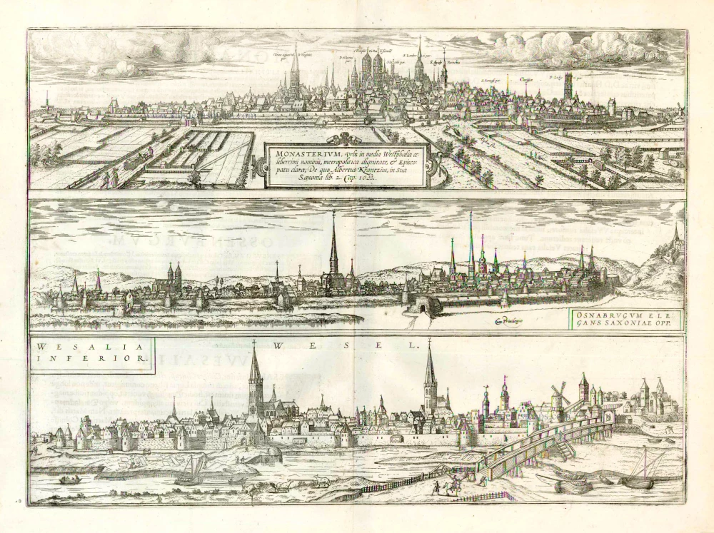
Monasterium, Urbs in Media Westphalia Celeberrimi Nominis ... [on sheet with] Osnabrugum Elegans Saxoniae Opp. [and] Wesalia Inferior. 1612
Münster, Osnabrück and Wesel, by Georg Braun and Frans Hogenberg.
[Item number: 22320]
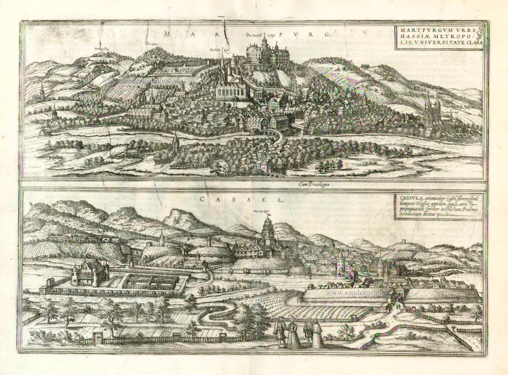
Marpurg. - Martpurgum Urbs Hassiae Metropolis, Universitate Clara [on sheet with] Cassel. - Cassula, Communiter Cassel, Florentissimu Lanigerae Oppidum 1612
Marburg and Cassel, by Georg Braun and Frans Hogenberg.
[Item number: 22324]

Dresden - Dresa Florentissimum Misniae Opp. Illust: Saxoniae Ducum Sedes [on sheet with] Leibzigk - Lipsia Litterarum Studiis et Mercatura Celebre Misniae Oppidum 1612
Dresden and Leipzig, by Georg Braun and Frans Hogenberg.
[Item number: 22326]
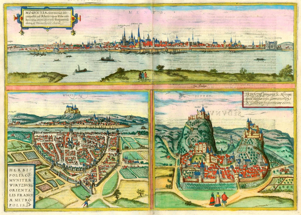
Moguntia, Germaniae Metropolis, ... [on sheet with] Herbipolis, comuniter Wirtzburg, ... [and] Sedunum, primaria & Metropolitica ... 1635
Mainz, Würzburg and Sitten, by Georg Braun and Frans Hogenberg.
[Item number: 22335]
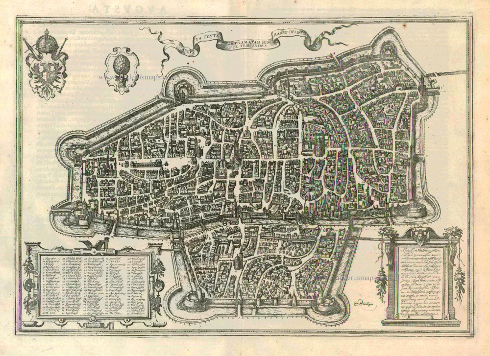
Augusta Iuxta Figuram ... 1612
Augsburg, by Georg Braun and Frans Hogenberg.
[Item number: 22337]
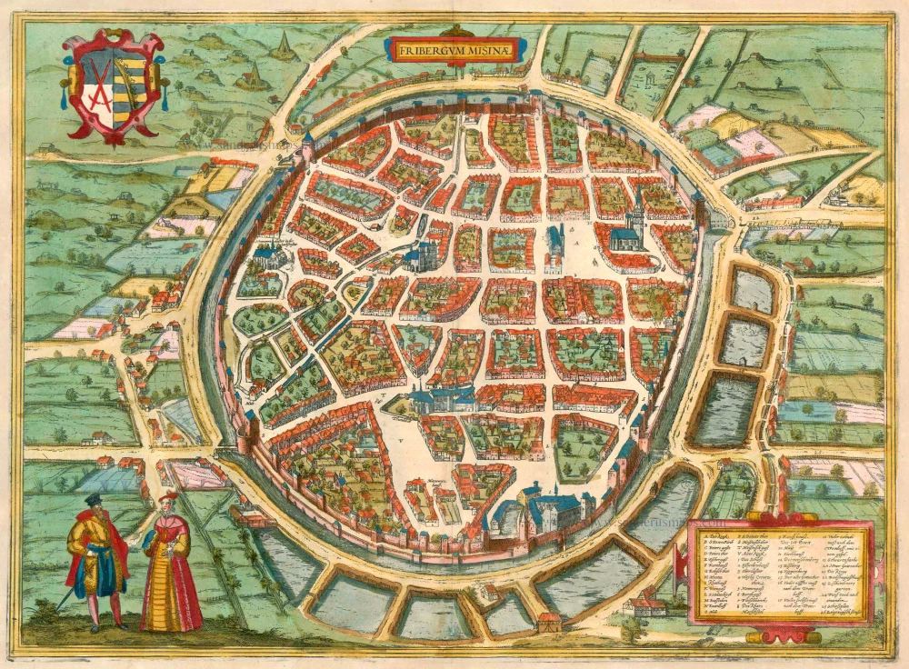
Fribergum Misinae 1575-1612
Freiberg (Saxony), by Georg Braun and Frans Hogenberg.
[Item number: 23279]
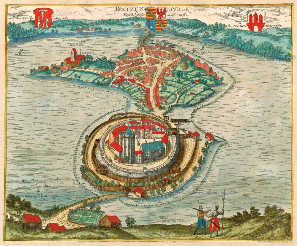
Ratzenburgk 1596
Ratzeburg, by Braun & Hogenberg.
[Item number: 23384]
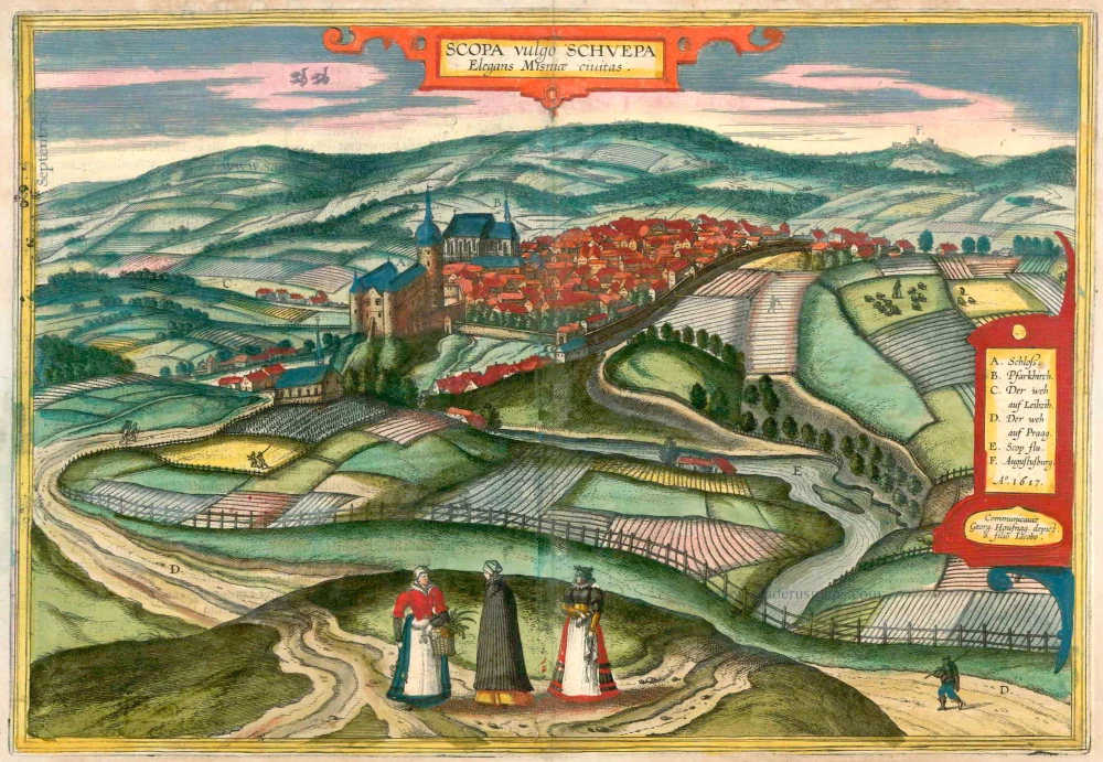
Scopa vulgo Schuepa Elegans Misniae Civitas 1618
Zschopau, by Braun & Hogenberg
[Item number: 23419]
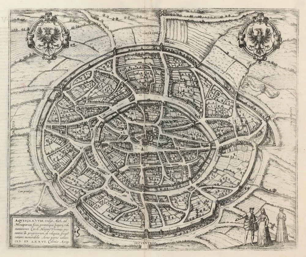
Aquisgranum, vulgo Aich, ad Menapiorum fines, perantiqua Imperij Urbs, M0onumento Caroli Magni, ... 1599
Aachen, by Georg Braun and Frans Hogenberg.
[Item number: 23907]
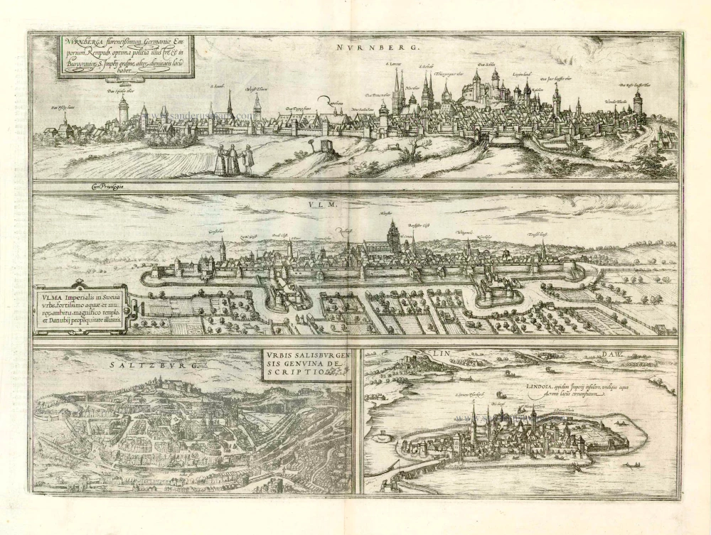
Nurnberga Florentissimum Germaniae Emporium, ... [on sheet with] Ulma Imperialis in Suevia [and] Saltzburg Urbis Salisburgensis Genvina Descriptio [and] Lindaw - Lindoia, Oppidum Imperij insulare, ... 1599
Nürnberg, Ulm, Salzburg, and Lindau, by Georg Braun and Frans Hogenberg.
[Item number: 23926]
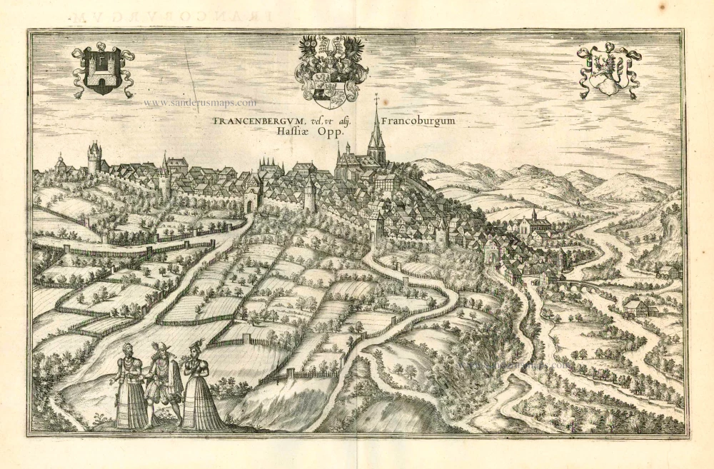
Francenbergum, vel ut alij Francoburgum Hassiae Opp. 1599
Frankenberg, by Georg Braun and Frans Hogenberg.
[Item number: 24053]

Penigk Misniae Oppidum. c. 1625
Penig by Georg Braun & Frans Hogenberg after Georg Hoefnagel.
[Item number: 24587]
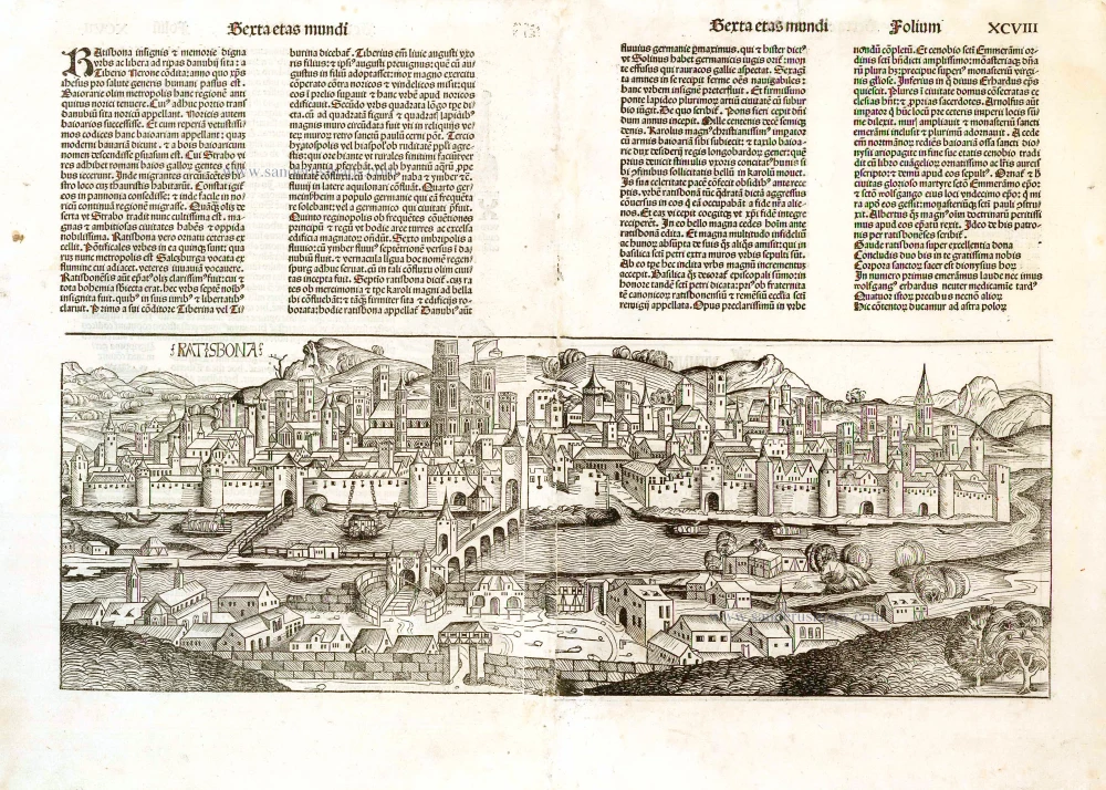
Ratisbona. 1493
Regensburg, by H. Schedel.
[Item number: 26582]
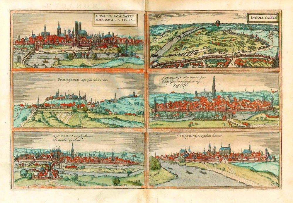
Monacum, nominatis sima Bavariae, Civitas [on sheet with] Ingolstadium [and] Frisingensis ... [and] Nordlinga ... [and] Ratispona ... [and] Straubinga ...
1577
München, Ingolstadt, Freissing, Nördlingen, Regensburg and Straubing, by Georg Braun and Frans Hogenberg.
[Item number: 26679]
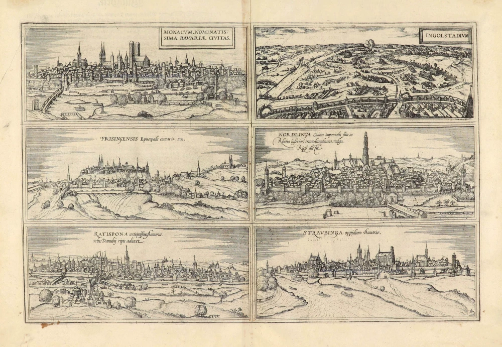
Monacum, nominatis sima Bavariae, Civitas. [on sheet with] Ingolstadium. [and] Frisingensis Episcopalis civitatis icon. [and] Nordlinga Civitas imperialis sita in Rhetia inferioris transdanubiana, vulgo Rieß dicta. [and] Ratispona antiquissima Bavariae urbs, Danubij ripis adiacet. [and] Straubinga oppidum Bavariae. 1574
München, Ingolstadt, Freising, Nördlingen, Regensburg and Straubing, by Georg Braun & Frans Hogenberg.
[Item number: 28041]