
The most mystical world map of all time.
Daniel's Dream Map. The Wittenberg world map. 1560-1600
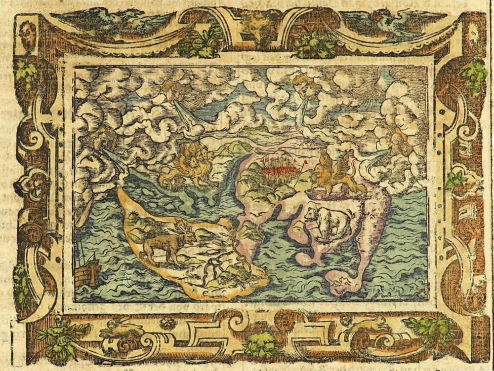
A somewhat curious map of Europe, Africa, and Asia is found in apocalyptic literature originally emanating from Wittenberg in 1530 or even 1529. One of the first impressions of the map was used by the printer Hans Lufft to illustrate two works: one a commentary on the prophet Daniel by Martin Luther (1530) and another linking the vision of Daniel with the assaults of the Turks on the perimeters of Christian Europe at the time. Later, a smaller block was cut, and the map from this was used in editions of Luther's Wittenberg Bible from 1534 onwards.
The map is a crude woodcut showing the four beasts of Daniel's dream and the simplified continents of Europe, Africa and Asia. It is known as the 'Wittenberg World Map' or 'Daniel's Dream Map'.
The engraver's initials, Virgil Solis, are at the bottom of the map.
[No title]
Item Number: 28159 Authenticity Guarantee
Category: Antique maps > World
Old, antique world map, Daniel's Dream Map, by Lufft Hans.
Title: [No title]
Date of the first edition: 1530.
Date of this map: c. 1560.
See link: https://daniels-dream-map.com
version 7, block 1.
Woodcut, printed on paper.
Size (not including margins): 80 x 120mm (3.15 x 4.72 inches).
Verso: German text.
Condition: Hand coloured, good.
Condition Rating: A+.
References: Shirley (World), 65A
From: German Luther Bible, c. 1560.
A somewhat curious map of Europe, Africa, and Asia is found in apocalyptic literature originally emanating from Wittenberg in 1530 or even 1529. One of the first impressions of the map was used by the printer Hans Lufft to illustrate two works: one a commentary on the prophet Daniel by Martin Luther (1530) and another linking the vision of Daniel with the assaults of the Turks on the perimeters of Christian Europe at the time. Later, a smaller block was cut, and the map from this was used in editions of Luther's Wittenberg Bible from 1534 onwards.
The map is a crude woodcut showing the four beasts of Daniel's dream and the simplified continents of Europe, Africa and Asia. It is known as the 'Wittenberg World Map' or 'Daniel's Dream Map'.
The engraver's initials, Virgil Solis, are at the bottom of the map.
Related items

Rare variant.
Cosmographia Universalis. 1592
World map by H. Bünting - D.A. Veleslavina.
[Item number: 26356]

Mapmonde ou description generale du Globe Terrestre. 1713
World map by Zacharias Châtelain.
[Item number: 29555]
Typus Orbis Terrarum. 1589
The world by Abraham Ortelius / Philippe Galle.
[Item number: 29605]

Mercator projection
Discorso Intorno alla Carta da Navigare. 1590
World by Thomaso Porcacchi.
[Item number: 29786]

Rare original colour.
Typus Orbis Terrarum - Globus Terrestris. 1609
Two world maps by A. Ortelius, published by J.B. Vrients.
[Item number: 29861]

'One of the supreme examples of map maker's art' (Shirley)
Nova Totius Terrarum Orbis Geographica ac Hydrographica. 1643
World by Willem Blaeu, in Mercator projection.
[Item number: 30271]
Orbis Terrae Compendiosa Descriptio. 1613
World by Mercator Rumold, double hemisphere.
[Item number: 30942]

Mappe-Monde Geo-Hydrographique, ou Description Generale du Globe Terrestre et Aquatique en Deux Plans-Hemispheres ... 1692
World map by Nicolas Sanson, so-called published by Hubert Jaillot. (Pirated edition by Pierre Mortier).
[Item number: 31136]

Typus Orbis Terrarum. 1618
World by Petrus Bertius, published by Jodocus Hondius II.
[Item number: 31520]

Gottfried's first edition 1631
[no title] 1631
Willem C. Schouten, world map published by Gottfried.
[Item number: 31560]

Rare first edition
[no title] 1618
World map in two hemispheres by Willem W. Schouten.
[Item number: 31601]

An Essay of a New and Compact Map, containing the known parts of the Terrestrial Globe. 1750
World map by Jacques-Nicolas Bellin, published by A.F. Prévost.
[Item number: 31883]

Beautiful example of this important world map
Typus Orbis Terrarum. 1584
World by Abraham Ortelius.
[Item number: 32090]

Planiglobii Terrestris cum Utroq Hemisphaerio Caelesti Generalis Repraesentatio. c. 1720
World by Homann J.B., double hemisphere.
[Item number: 32099]

Early Mercator projection
Universi Orbis Descriptio Ad Usum Navigantium. 1597
World by Giovanni Magini.
[Item number: 32281]

Carta Marina Nuova Tavola. 1574
World chart by Girolamo Ruscelli.
[Item number: 32432]

Orbis Descriptio. 1574
World in two hemisperes, by Girolamo Ruscelli.
[Item number: 32433]

Mappa Mondo O Vero Carta Generale Del Globo Terestre 1677
World in two hemisphers by Giovanni De Rossi, after Nicolas Sanson.
[Item number: 32885]

Typus Orbis Terrarum. 1618
World by Petrus Bertius.
[Item number: 33183]
new