
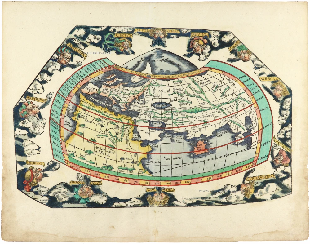
Old antique map of the World by Sebastian Münster 1568
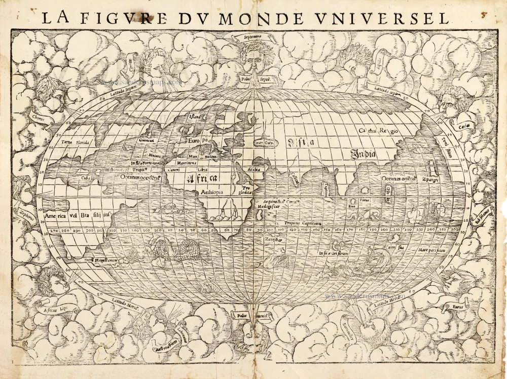
"Munster's 'modern' map of the world is an oval projection with a vigorous surround of clouds and lusty windheads. The east and west heads are placed inside the oval circumference. It is a woodcut, like all the maps he produced, and most of the type of the lettering has been set separately in rectangular inserts. The continents are shown in rough outline only, with the Americas taking on an unusual shape, Florida and Francisca are almost separated by a deep cleft of water, and, further north, the Terra nova sive de Bacalhos is part of a huge promontory extending as far as and joining onto Scandinavia. The channel between this land mass and Francisca bears the legend 'This strait leads to the Moluccas'. It would appear that Münster's map is based on a combination of information derived from Verrazzano's explorations of 1522-24 when the waters of Chesapeake Bay were mistaken for the Indian Ocean, and reports of Cartier's voyages of 1534-35 up the St. Lawrence seaway into the Great Lakes vainly searching for the north-west passage. The west coast of North America, hypothetically drawn, carries the name Temistitan, generally used to denote Mexico. In Africa, the course of the Nile is prominent, with its twin sources terminating in a range of mountains. Unidentified islands Grisonum and Calensuan are placed in proximity to Australia, while for the first time on a printed map, the Pacific Ocean (Mare Pacificum) receives its name." (Shirley)
The woodcut border surrounding the type on the verso of the map is the work of Hans Holbein.
Sebastian Münster (1488-1552)
Sebastian Münster, a German geographer, cartographer, Hebraist, and theologian, was born in Ingelheim, near Mainz In 1505, he went to Heidelberg to enter the Franciscan order. In 1507 he went to Louvain, where he studied mathematics, geography, and astronomy. In 1509 Münster became a student of Konrad Pelikan, who taught Hebrew and Greek as well as mathematics and cosmography. In 1518 he completed his studies at the University of Tübingen. He was the favorite of the famous mathematician and astronomer Johann Stöffler.
In 1524 Münster was appointed professor of Hebrew at Heidelberg University. In 1525 he published his first map as part of a broadside: The Instrument of the Suns combined a map, calendar, astrological almanac, sundial, and nocturnal on one attractive sheet, suitable for wall mounting.
In 1540 he published a Latin edition of Ptolemy's Geographia with illustrations. He based this edition on the Latin translation by Willibald Pirkheimer and produced new maps to supplement the Ptolemaic maps. The twenty-seven maps of the Ptolemaic canon are supplemented by twenty-one new maps. Further editions appeared in 1541 and 1542.
In 1544 he published the Cosmographia, a bulky book with 659 pages and some 520 woodcuts. Maps in this edition included three maps from the Ptolemaic canon and fourteen modern maps (from previous editions of the Geographia), as well as nine new maps. Later editions (1545, 1546, 1548) enlarged the Cosmographia. The 1550 edition contains cities, portraits, and costumes. These editions in both Latin and German constitute the full fruition of Münster's dream of a comprehensive geography.
The Cosmographia was one of the most successful works of the 16th century. It passed through 24 editions in 100 years, in different languages, including Latin, French, Italian, English, and even Czech. The last German edition was published in 1628.
He died at Basel of the plague in 1552.
As a cartographer, Münster deserves special recognition for formulating a plan for a comprehensive and uniform map of a country. As a geographer, his greatest achievement was the Cosmographia. (Karrow).
La Figure du Monde Universel
Item Number: 30533 Authenticity Guarantee
Category: Antique maps > World
Old antique map of the World by Sebastian Münster.
Title: La Figure du Monde Universel
Woodcutter: David Kandel (his monogram in the bottom left corner).
Date of the first edition: 1550.
Date of this map: 1568.
Woodcut, printed on paper.
Image size: 260 x 380mm (10.24 x 14.96 inches).
Sheet size: 300 x 395mm (11.81 x 15.55 inches).
Verso: French text.
Condition: Small repair at lower centrefold, light stained, right margin frayed.
Condition Rating: A.
From: Münster S. Cosmographie universelle, contenant la situation de toutes les parties du monde ... Basel, Henry Pierre, 1568.
"Munster's 'modern' map of the world is an oval projection with a vigorous surround of clouds and lusty windheads. The east and west heads are placed inside the oval circumference. It is a woodcut, like all the maps he produced, and most of the type of the lettering has been set separately in rectangular inserts. The continents are shown in rough outline only, with the Americas taking on an unusual shape, Florida and Francisca are almost separated by a deep cleft of water, and, further north, the Terra nova sive de Bacalhos is part of a huge promontory extending as far as and joining onto Scandinavia. The channel between this land mass and Francisca bears the legend 'This strait leads to the Moluccas'. It would appear that Münster's map is based on a combination of information derived from Verrazzano's explorations of 1522-24 when the waters of Chesapeake Bay were mistaken for the Indian Ocean, and reports of Cartier's voyages of 1534-35 up the St. Lawrence seaway into the Great Lakes vainly searching for the north-west passage. The west coast of North America, hypothetically drawn, carries the name Temistitan, generally used to denote Mexico. In Africa, the course of the Nile is prominent, with its twin sources terminating in a range of mountains. Unidentified islands Grisonum and Calensuan are placed in proximity to Australia, while for the first time on a printed map, the Pacific Ocean (Mare Pacificum) receives its name." (Shirley)
The woodcut border surrounding the type on the verso of the map is the work of Hans Holbein.
Sebastian Münster (1488-1552)
Sebastian Münster, a German geographer, cartographer, Hebraist, and theologian, was born in Ingelheim, near Mainz In 1505, he went to Heidelberg to enter the Franciscan order. In 1507 he went to Louvain, where he studied mathematics, geography, and astronomy. In 1509 Münster became a student of Konrad Pelikan, who taught Hebrew and Greek as well as mathematics and cosmography. In 1518 he completed his studies at the University of Tübingen. He was the favorite of the famous mathematician and astronomer Johann Stöffler.
In 1524 Münster was appointed professor of Hebrew at Heidelberg University. In 1525 he published his first map as part of a broadside: The Instrument of the Suns combined a map, calendar, astrological almanac, sundial, and nocturnal on one attractive sheet, suitable for wall mounting.
In 1540 he published a Latin edition of Ptolemy's Geographia with illustrations. He based this edition on the Latin translation by Willibald Pirkheimer and produced new maps to supplement the Ptolemaic maps. The twenty-seven maps of the Ptolemaic canon are supplemented by twenty-one new maps. Further editions appeared in 1541 and 1542.
In 1544 he published the Cosmographia, a bulky book with 659 pages and some 520 woodcuts. Maps in this edition included three maps from the Ptolemaic canon and fourteen modern maps (from previous editions of the Geographia), as well as nine new maps. Later editions (1545, 1546, 1548) enlarged the Cosmographia. The 1550 edition contains cities, portraits, and costumes. These editions in both Latin and German constitute the full fruition of Münster's dream of a comprehensive geography.
The Cosmographia was one of the most successful works of the 16th century. It passed through 24 editions in 100 years, in different languages, including Latin, French, Italian, English, and even Czech. The last German edition was published in 1628.
He died at Basel of the plague in 1552.
As a cartographer, Münster deserves special recognition for formulating a plan for a comprehensive and uniform map of a country. As a geographer, his greatest achievement was the Cosmographia. (Karrow).
Related items

Rare variant.
Cosmographia Universalis. 1592
World map by H. Bünting - D.A. Veleslavina.
[Item number: 26356]

Universi Orbis Descriptio. 1597
World by Giovanni Magini
[Item number: 27837]
The most mystical world map of all time.
[No title] 1560-1600
Daniel's Dream Map. The Wittenberg world map.
[Item number: 28159]
Descrittione Del Mappamondo. 1572
World by Porcacchi Tommaso.
[Item number: 28910]
Mercator projection
Discorso Intorno alla Carta da Navigare. 1590
World by Thomaso Porcacchi.
[Item number: 29786]
Rare 1525 edition in nice old colour.
[No title] 1525
Ptolemaic world by Lorenz Fries after Martin Waldseemüller.
[Item number: 30649]
Orbis Terrae Compendiosa Descriptio. 1613
World by Mercator Rumold, double hemisphere.
[Item number: 30942]

Mappe-Monde Geo-Hydrographique, ou Description Generale du Globe Terrestre et Aquatique en Deux Plans-Hemispheres ... 1692
World map by Nicolas Sanson, so-called published by Hubert Jaillot. (Pirated edition by Pierre Mortier).
[Item number: 31136]
Typus Orbis Terrarum. 1618
World by Petrus Bertius, published by Jodocus Hondius II.
[Item number: 31520]

Gottfried's first edition 1631
[no title] 1631
Willem C. Schouten, world map published by Gottfried.
[Item number: 31560]

Rare first edition
[no title] 1618
World map in two hemispheres by Willem W. Schouten.
[Item number: 31601]

An Essay of a New and Compact Map, containing the known parts of the Terrestrial Globe. 1750
World map by Jacques-Nicolas Bellin, published by A.F. Prévost.
[Item number: 31883]

Beautiful example of this important world map
Typus Orbis Terrarum. 1584
World by Abraham Ortelius.
[Item number: 32090]
Planiglobii Terrestris cum Utroq Hemisphaerio Caelesti Generalis Repraesentatio. c. 1720
World by Homann J.B., double hemisphere.
[Item number: 32099]

Early Mercator projection
Universi Orbis Descriptio Ad Usum Navigantium. 1597
World by Giovanni Magini.
[Item number: 32281]

Carta Marina Nuova Tavola. 1574
World chart by Girolamo Ruscelli.
[Item number: 32432]

Orbis Descriptio. 1574
World in two hemisperes, by Girolamo Ruscelli.
[Item number: 32433]

Mappa Mondo O Vero Carta Generale Del Globo Terestre 1677
World in two hemisphers by Giovanni De Rossi, after Nicolas Sanson.
[Item number: 32885]
new