
Parergon map
The Holy Land by Abraham Ortelius. 1612
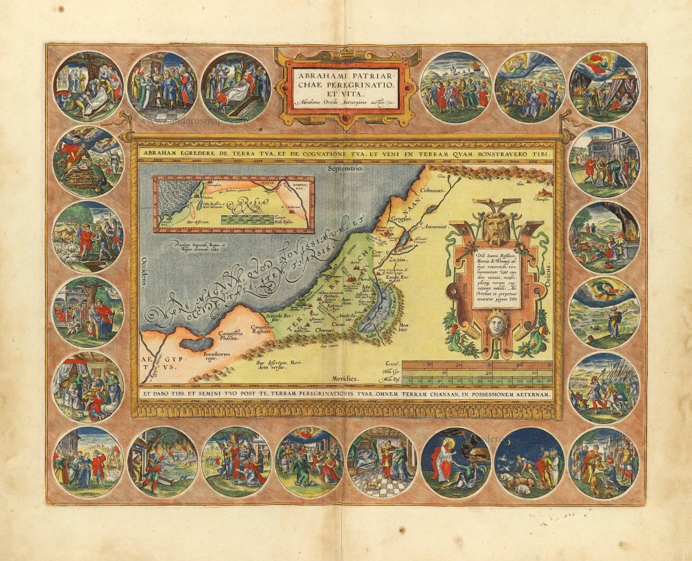


Ortelius included this map, illustrating the land of Canaan in the time of the Patriarchs, in the fourth addition to his atlas in 1590. It became part of the expanding supplement of historical maps, entitled Parergon, that Ortelius appended to his atlas of modern maps. Largely the work of the master himself, the maps in the Parergon, and this one, are the best engravings reflecting the widespread sixteenth-century interest in classical geography.
The delineation follows closely the familiar map of Tilleman Stella, the first map of the Holy Land to be included in an Ortelius atlas. However, territorial divisions are taken from Abraham's story in Genesis. Ancient tribal names are preserved in the regions of the Philistines, Amalekites, Jebusites, Cenezites, and Gergesenes. The cities of Sodom and Gomorrah still drive along southern Jordan in the "Valley of the Forest of Salt," which was to become the Dead Sea. An inset shows the stages in the wanderings of Abraham, from Ur of the Chaldees, in the lower Euphrates Valley, to Shechem, Bethel, Damascus, Egypt, and Hebron.
In keeping with the title and biblical theme of the engraving, twenty-two medallions depicting scenes from the life of Abraham surround the map. The map is framed by an inscription containing the promise to Abraham.
The Wanderings of Abraham is among the most elaborate of Ortelius's compositions. It demonstrates his combined skills as a cartographer and an artist and his accomplishment as a historian. Ortelius imaginatively enlivened the earliest period of biblical history for the readers of his Parergon.
The medallions have been engraved after designs drawn by Maarten de Vos.
Abraham Ortelius (1527-1598)
The maker of the 'first atlas', the Theatrum Orbis Terrarum (1570), was born on 4 April 1527 into an old Antwerp family. He learned Latin and studied Greek and mathematics.
Abraham and his sisters Anne and Elizabeth took up map colouring. Ortelius was admitted to the Guild of St. Luke as an "illuminator of maps." In addition to colouring maps, Ortelius was a dealer in antiques, coins, maps, and books, and the book and map trade gradually became his primary occupation.
Business went well because his means permitted him to start an extensive collection of medals, coins, antiques, and a library of many volumes. In addition, he travelled a lot, visited Italy and France, made contacts everywhere with scholars and editors, and maintained extensive correspondence with them.
In 1564, he published his first map, a large and ambitious world wall map. The inspiration for this map may well have been Gastaldi's large world map. In 1565, he published a map of Egypt and a map of the Holy Land; a large map of Asia followed.
In 1568, the production of individual maps for his atlas Theatrum Orbis Terrarum was already in full swing. He completed the atlas in 1569, and in May 1570, it was available for sale. It was one of the most expensive books ever published.
This first edition contained seventy maps on fifty-three sheets. Franciscus Hogenberg engraved the maps.
Later editions included Additamenta (additions), resulting in Ortelius' historical atlas, the Parergon, which is mainly bound together with the atlas. The Parergon can be considered a truly original work by Ortelius, who drew the maps based on his research.
The importance of the Theatrum Orbis Terrarum for geographical knowledge in the last quarter of the sixteenth century is difficult to overemphasize. Nothing was like it until Mercator's atlas appeared twenty-five years later. Demand for the Theatrum was remarkable. Some 24 editions appeared during Ortelius's lifetime and another 10 after he died in 1598. Editions were published in Dutch, German, French, Spanish, English, and Italian. The number of map sheets grew from 53 in 1570 to 167 in 1612 in the last edition.
In 1577, engraver Philip Galle and poet-translator Pieter Heyns published the first pocket-sized edition of the Theatrum, the Epitome. The work was trendy. Over thirty editions of this Epitome were published in different languages.
Abrahami Patriarchae Peregrinatio, et Vita.
Item Number: 28921 Authenticity Guarantee
Category: Antique maps > Asia > Holy Land
Old, antique map of the Holy Land, by Abraham Ortelius.
Title: Abrahami Patriarchae Peregrinatio, et Vita.
Abrahamo Ortelio Antverpianoauctore.
Privilegio Imperiali, Rego et Belgico decennali. 1586.
Cartographer: Abraham Ortelius.
Date of the first edition: 1590.
Date of this map: 1612.
Date on map: Privilege for ten years: 1586.
Copper engraving, printed on paper.
Map size: 360 x 465mm (14.17 x 18.31 inches).
Sheet size: 480 x 540mm (18.9 x 21.26 inches).
Verso: Italian text.
Condition: Original coloured, excellent.
Condition Rating: A+.
From: Theatro del Mondo di Abrahamo Ortelio. Antwerpen, Plantin Press (J.&B. Moretus), 1612. (Van der Krogt 3, 1:652)
Ortelius included this map, illustrating the land of Canaan in the time of the Patriarchs, in the fourth addition to his atlas in 1590. It became part of the expanding supplement of historical maps, entitled Parergon, that Ortelius appended to his atlas of modern maps. Largely the work of the master himself, the maps in the Parergon, and this one, are the best engravings reflecting the widespread sixteenth-century interest in classical geography.
The delineation follows closely the familiar map of Tilleman Stella, the first map of the Holy Land to be included in an Ortelius atlas. However, territorial divisions are taken from Abraham's story in Genesis. Ancient tribal names are preserved in the regions of the Philistines, Amalekites, Jebusites, Cenezites, and Gergesenes. The cities of Sodom and Gomorrah still drive along southern Jordan in the "Valley of the Forest of Salt," which was to become the Dead Sea. An inset shows the stages in the wanderings of Abraham, from Ur of the Chaldees, in the lower Euphrates Valley, to Shechem, Bethel, Damascus, Egypt, and Hebron.
In keeping with the title and biblical theme of the engraving, twenty-two medallions depicting scenes from the life of Abraham surround the map. The map is framed by an inscription containing the promise to Abraham.
The Wanderings of Abraham is among the most elaborate of Ortelius's compositions. It demonstrates his combined skills as a cartographer and an artist and his accomplishment as a historian. Ortelius imaginatively enlivened the earliest period of biblical history for the readers of his Parergon.
The medallions have been engraved after designs drawn by Maarten de Vos.
Abraham Ortelius (1527-1598)
The maker of the 'first atlas', the Theatrum Orbis Terrarum (1570), was born on 4 April 1527 into an old Antwerp family. He learned Latin and studied Greek and mathematics.
Abraham and his sisters Anne and Elizabeth took up map colouring. Ortelius was admitted to the Guild of St. Luke as an "illuminator of maps." In addition to colouring maps, Ortelius was a dealer in antiques, coins, maps, and books, and the book and map trade gradually became his primary occupation.
Business went well because his means permitted him to start an extensive collection of medals, coins, antiques, and a library of many volumes. In addition, he travelled a lot, visited Italy and France, made contacts everywhere with scholars and editors, and maintained extensive correspondence with them.
In 1564, he published his first map, a large and ambitious world wall map. The inspiration for this map may well have been Gastaldi's large world map. In 1565, he published a map of Egypt and a map of the Holy Land; a large map of Asia followed.
In 1568, the production of individual maps for his atlas Theatrum Orbis Terrarum was already in full swing. He completed the atlas in 1569, and in May 1570, it was available for sale. It was one of the most expensive books ever published.
This first edition contained seventy maps on fifty-three sheets. Franciscus Hogenberg engraved the maps.
Later editions included Additamenta (additions), resulting in Ortelius' historical atlas, the Parergon, which is mainly bound together with the atlas. The Parergon can be considered a truly original work by Ortelius, who drew the maps based on his research.
The importance of the Theatrum Orbis Terrarum for geographical knowledge in the last quarter of the sixteenth century is difficult to overemphasize. Nothing was like it until Mercator's atlas appeared twenty-five years later. Demand for the Theatrum was remarkable. Some 24 editions appeared during Ortelius's lifetime and another 10 after he died in 1598. Editions were published in Dutch, German, French, Spanish, English, and Italian. The number of map sheets grew from 53 in 1570 to 167 in 1612 in the last edition.
In 1577, engraver Philip Galle and poet-translator Pieter Heyns published the first pocket-sized edition of the Theatrum, the Epitome. The work was trendy. Over thirty editions of this Epitome were published in different languages.
Related items
Tribus Aser 1590
The Holy Land, by Adrichomius C.
[Item number: 1891]
Tribus Zabulon, Isachar, Et, Dimidia Manasse ... 1590
Holy Land, by Adrichomius C.
[Item number: 1902]
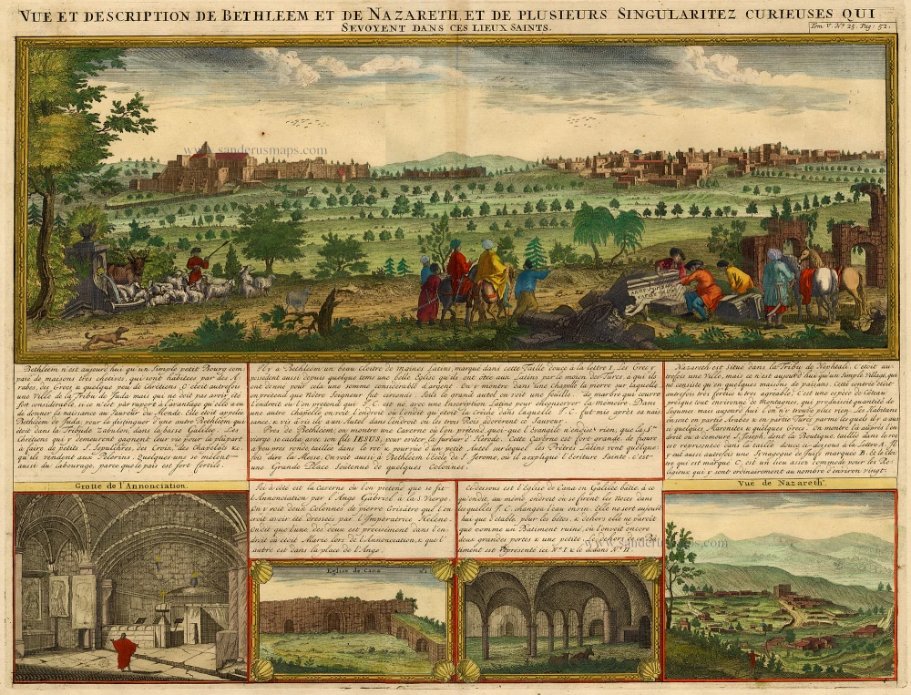
Vue et Description de Bethleem et de Nazareth et de Plusieurs Singularitez Curieuses .. 1719
Holy Land - Bethlehem - Nazareth, by Z. Châtelain.
[Item number: 16855]

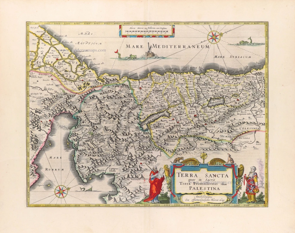
Terra Sancta quae in Sacris Terra Promissionis ol: Palestina 1630
HOLY LAND by Mercator - Janssonius
[Item number: 17710]
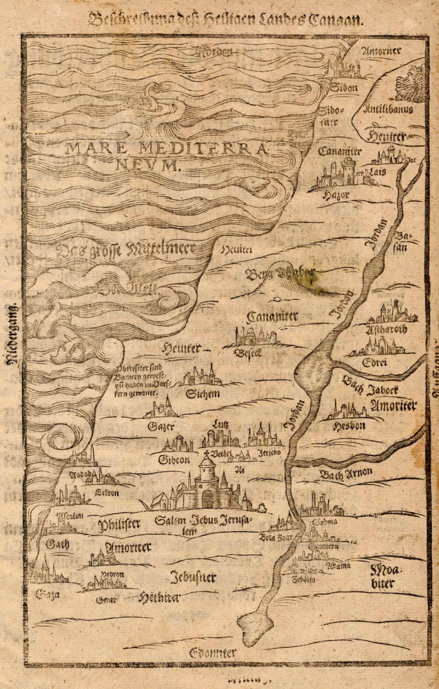
Beschreibung des Heiligen Landes Canaan. 1581
The Holy Land, by Bünting H.
[Item number: 18420]
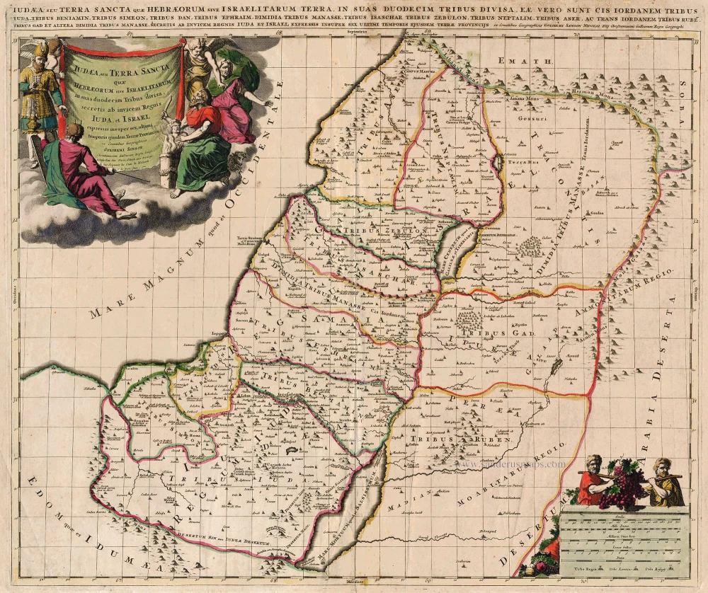
Iudaea, seu Terra Sancta quae Hebraeorum sive Israelitarum ... c. 1700
HOLY LAND by Schenk P.
[Item number: 19146]
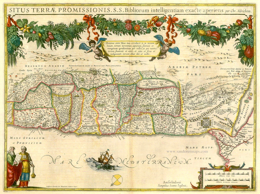
Situs Terrae Promissionis. S.S. Bibliorum intelligentiam exacte aperiens per Chr. Adrichom. c. 1658
The Holy Land, by Janssonius J.
[Item number: 19521]
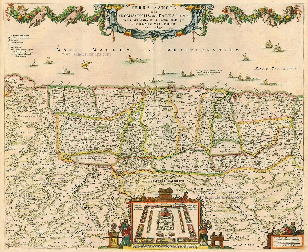
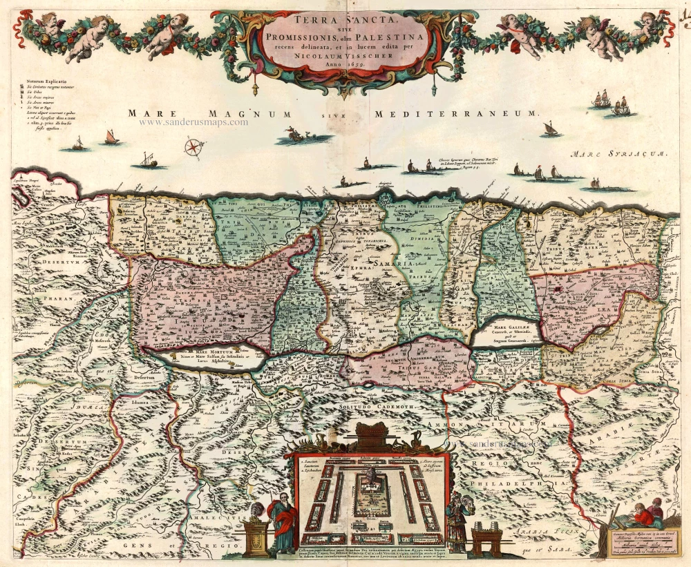
Terra Sancta, sive Promissionis, olim Palestina recens delineata. 1683-1696
The Holy Land, by Visscher N.
[Item number: 19522]
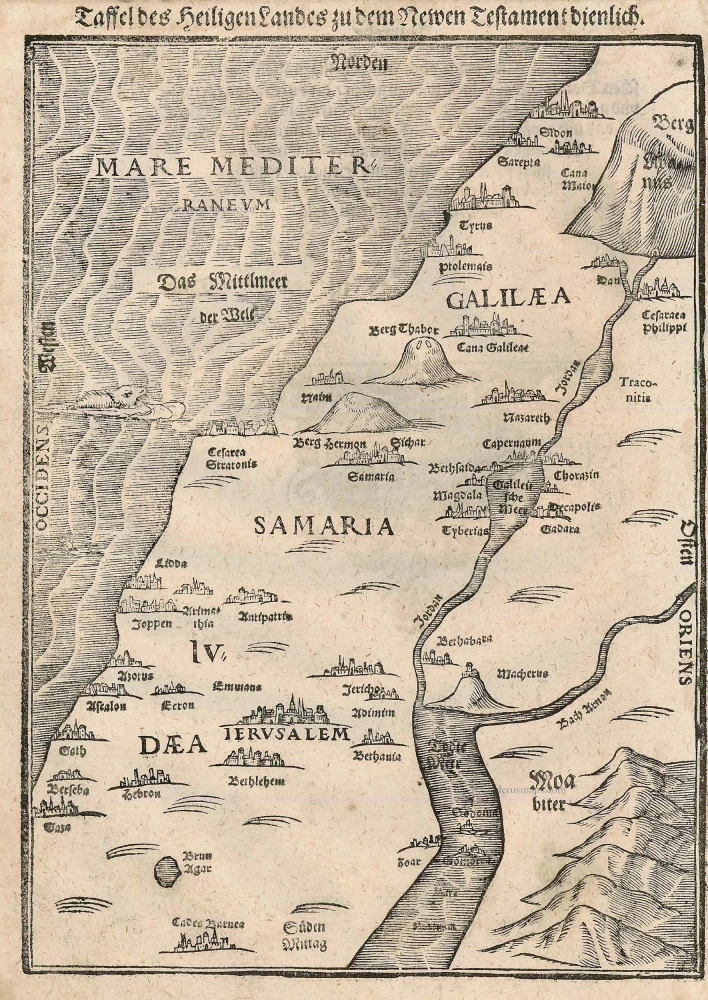
Taffel des Heiligen Landes zu dem Newen Testament dienlich. 1582
Holy Land, by Bünting H.
[Item number: 22640]
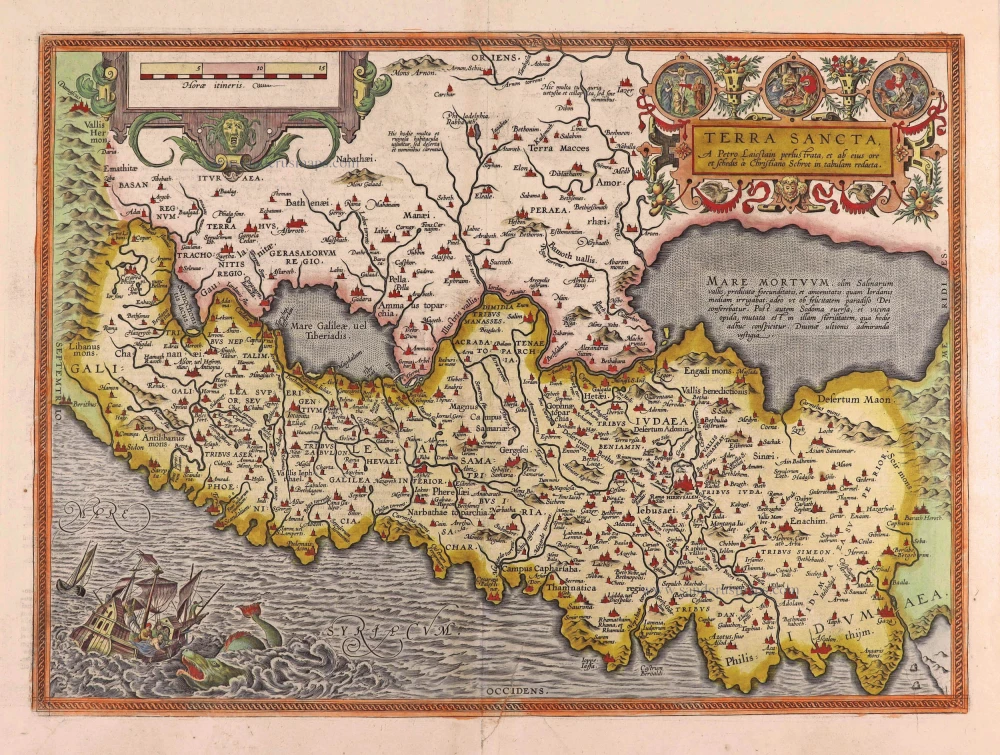
Terra Sancta, A Petro Laicstain perlustrata, et ab eius ore et schedisà Chistino Schrot in tabulam redacta. 1612
Holy Land by Abraham Ortelius.
[Item number: 23099]
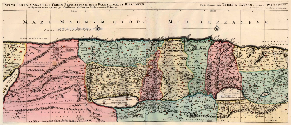
Situs Terrae Canaan sive Terrae Promissionis, hodie Palestinae, ... 1710
The Holy Land, by Jaillot - Covens & Mortier.
[Item number: 23600]
Terra Sancta, sive Promissionis, olim Palestina recens delineata. 1683-1696
The Holy Land by Nicolaas Visscher
[Item number: 24441]
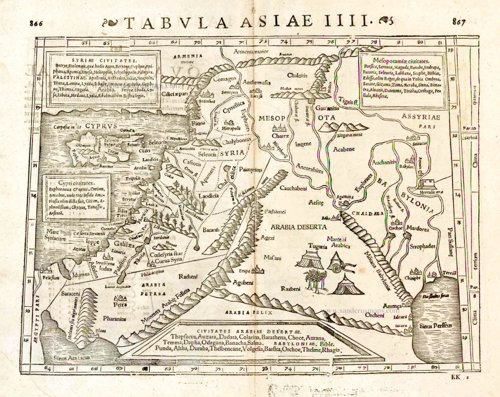
Tabula Asiae IIII. 1571
Middle East - Cyprus - Holy Land by Strabo - Sebastian Münster
[Item number: 25653]
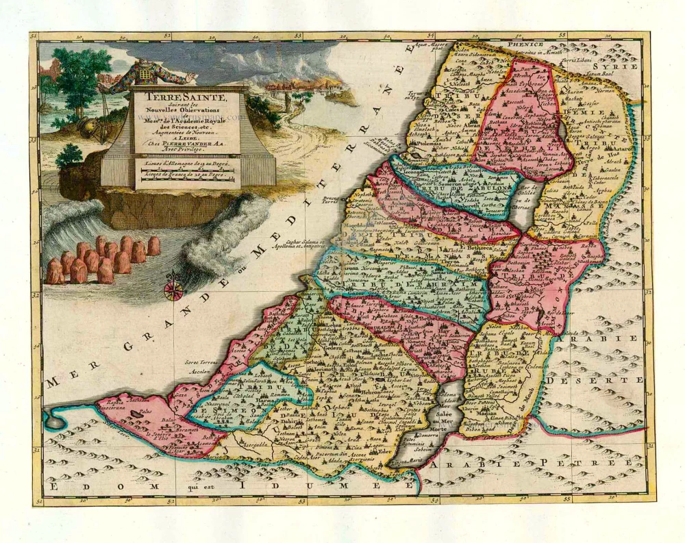
Terre Sainte Suivant les Nouvelles Observations. 1713
The Holy Land, by Pieter van der Aa.
[Item number: 26110]
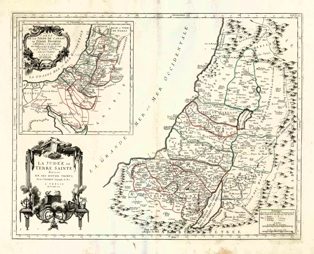
La Judée ou Terre Sainte divisée en ses Douze Tribus. 1776-79
Holy Land, by Paolo Santini.
[Item number: 27015]
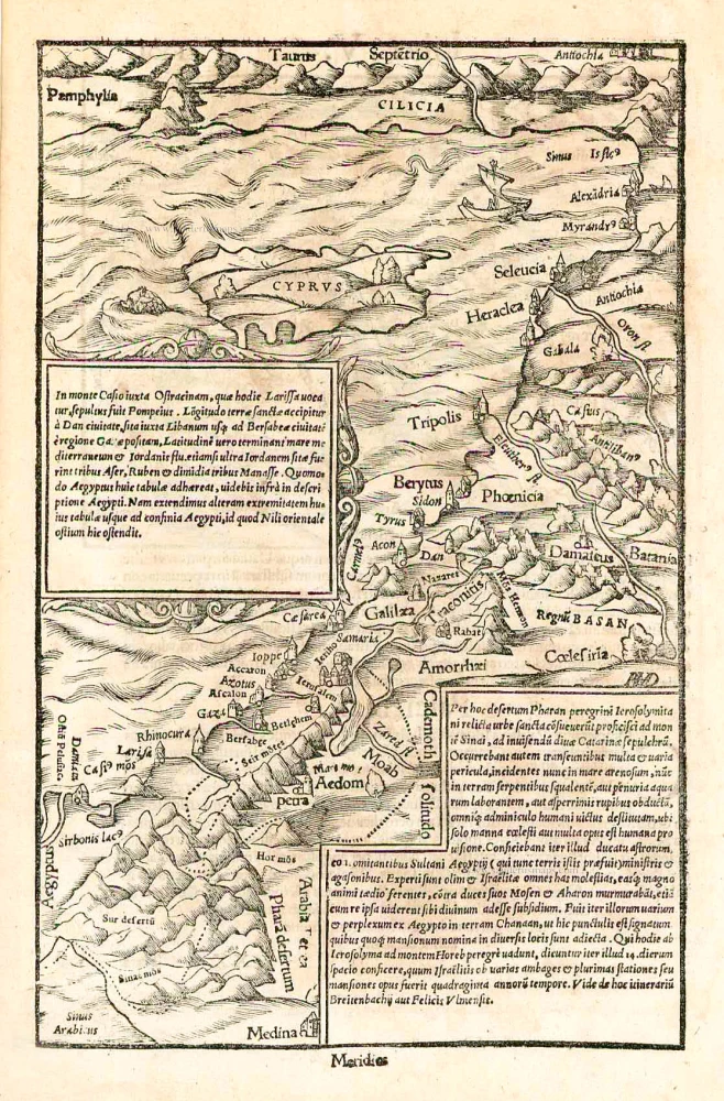
In monte Casio iuxta Ostracinam, ... 1550
Cyprus and the Holy Land, by Sebastian Münster.
[Item number: 27073]
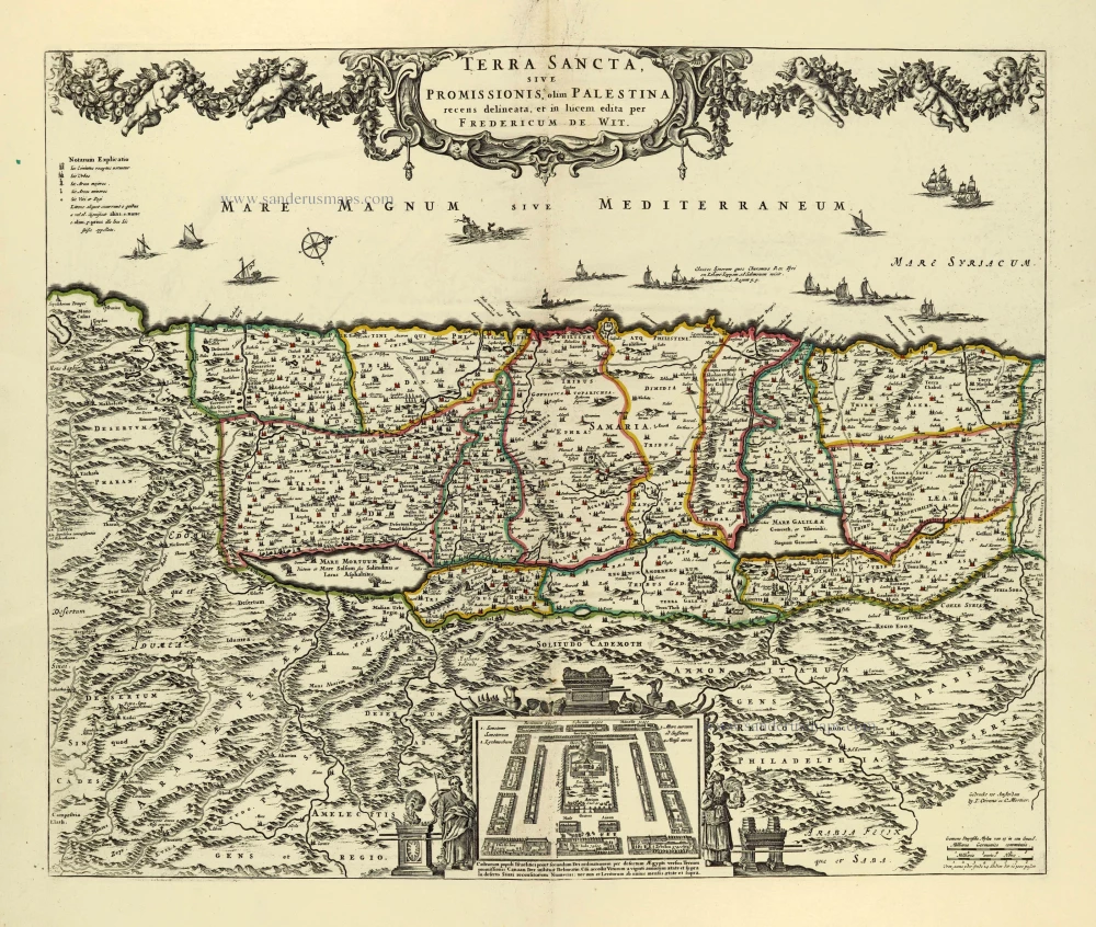
Terra Sancta, sive Promissionis, olim Palestina. after 1721
Holy Land by Frederik de Wit, published by Covens & Mortier.
[Item number: 28329]
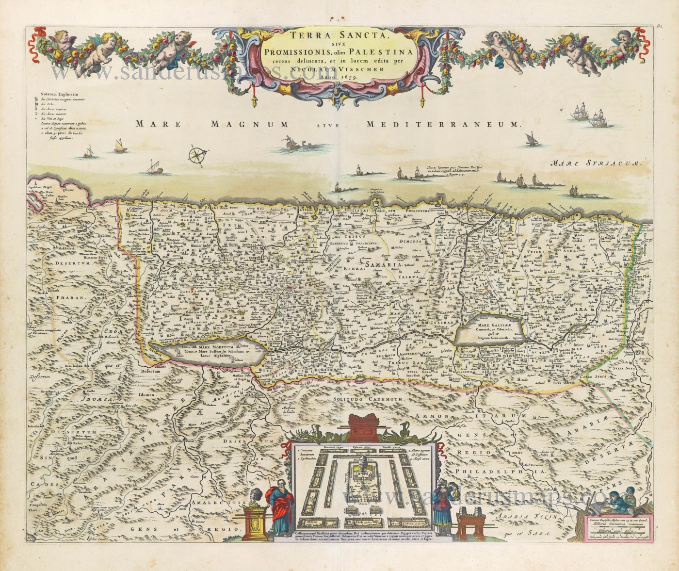
Terra Sancta, sive Promissionis, olim Palestina recens delineata. 1664-80
The Holy Land by Nicolaas Visscher.
[Item number: 28582]

Terra Sancta, A Petro Laicstain perlustrata, et ab eius ore et schedisà Chistino Schrot in tabulam redacta. 1601
Holy Land by Abraham Ortelius.
[Item number: 28669]
Parergon map
Abrahami Patriarchae Peregrinatio, et Vita. 1612
The Holy Land by Abraham Ortelius.
[Item number: 28921]
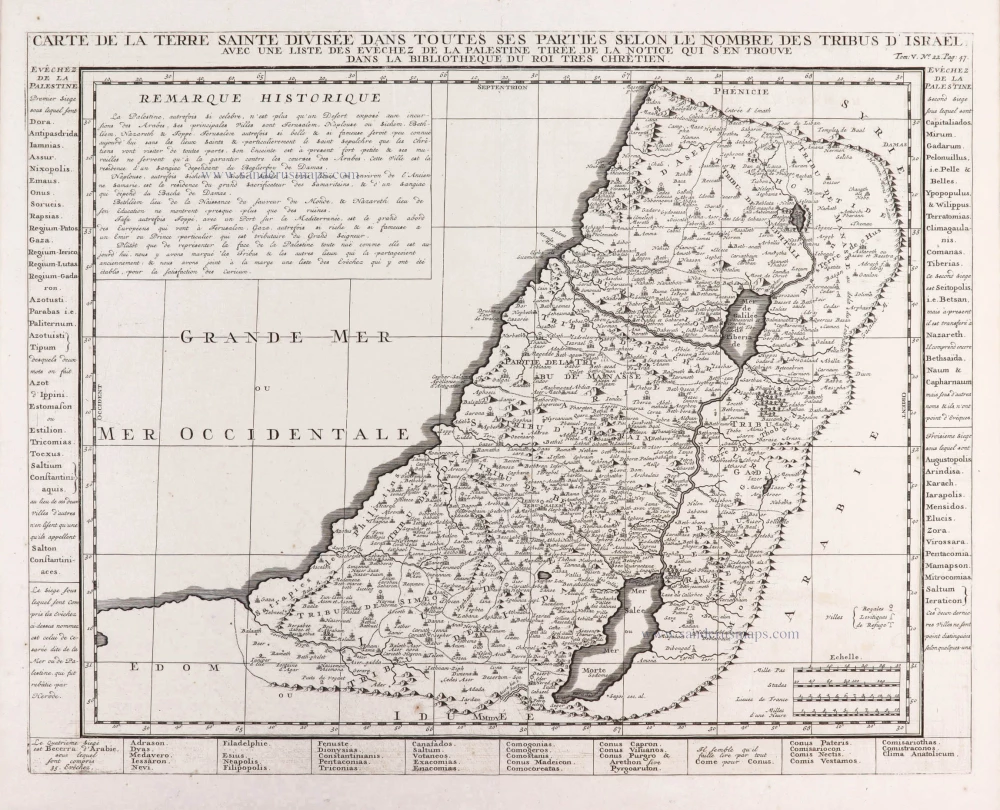
Carte de la Terre Sainte Divisée dans Toutes ses Parties selon le nombre des Tribus d'Israel. 1719
Holy Land, by Zacharias Châtelain.
[Item number: 29383]
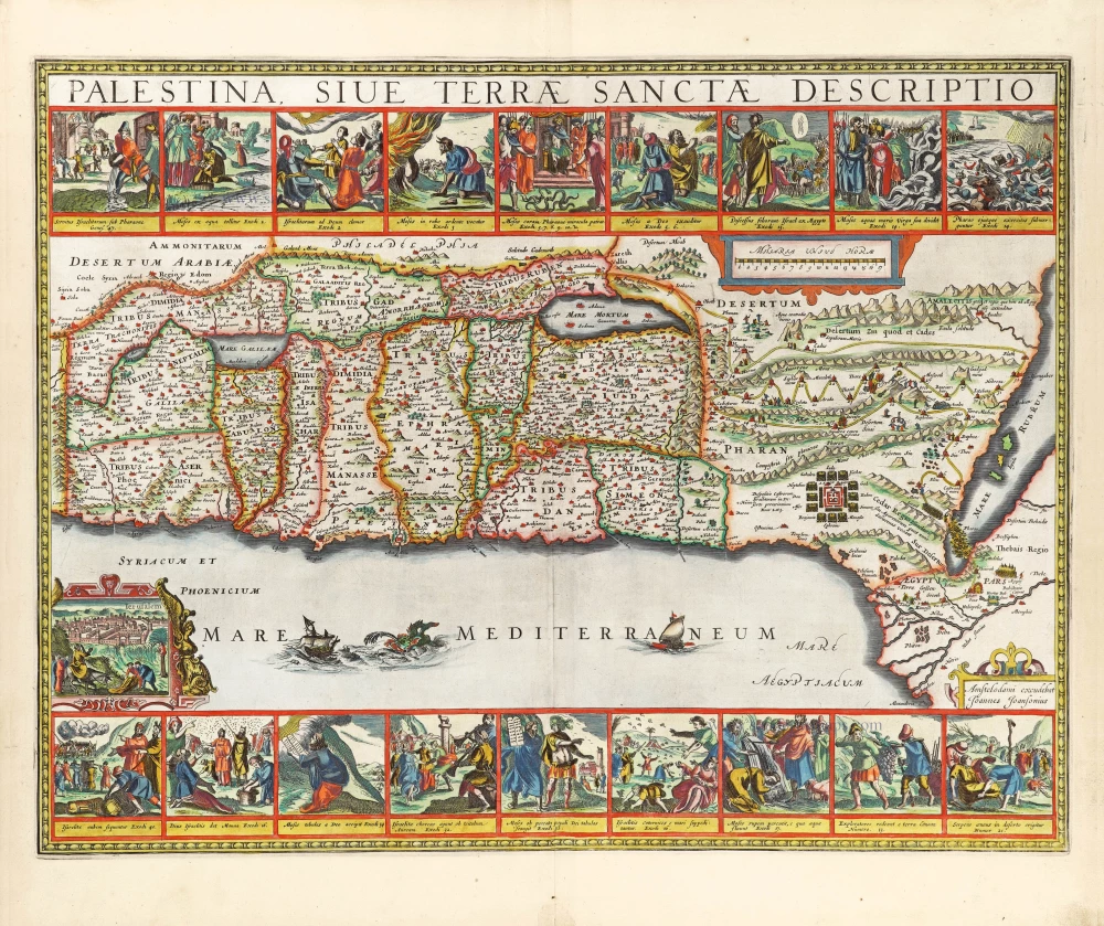
The most decorative map of the Holy Land to be included in a seventeenth century atlas
Palestina, sive Terrae Sanctae Descriptio. 1666
The Holy Land by Joannes Janssonius.
[Item number: 29972]
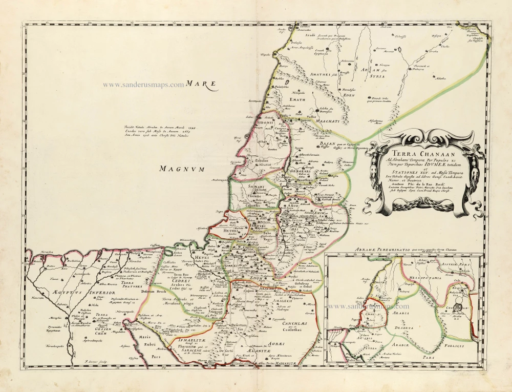
Terra Chanaan Ad Abrahami tempora, per populos XI Item per toparchias Idumeae Totidem et Stationes XLV. ad Mosis Tempora Seu Tabula digesta ad libros Genes. Exodi. Levit. Numer. et Deuteron. 1651
Historic map of the Land of Canaan from the time of Abraham up to the time of Moses, by Philippe de la Rue, published by Pierre Mariette.
[Item number: 30053]
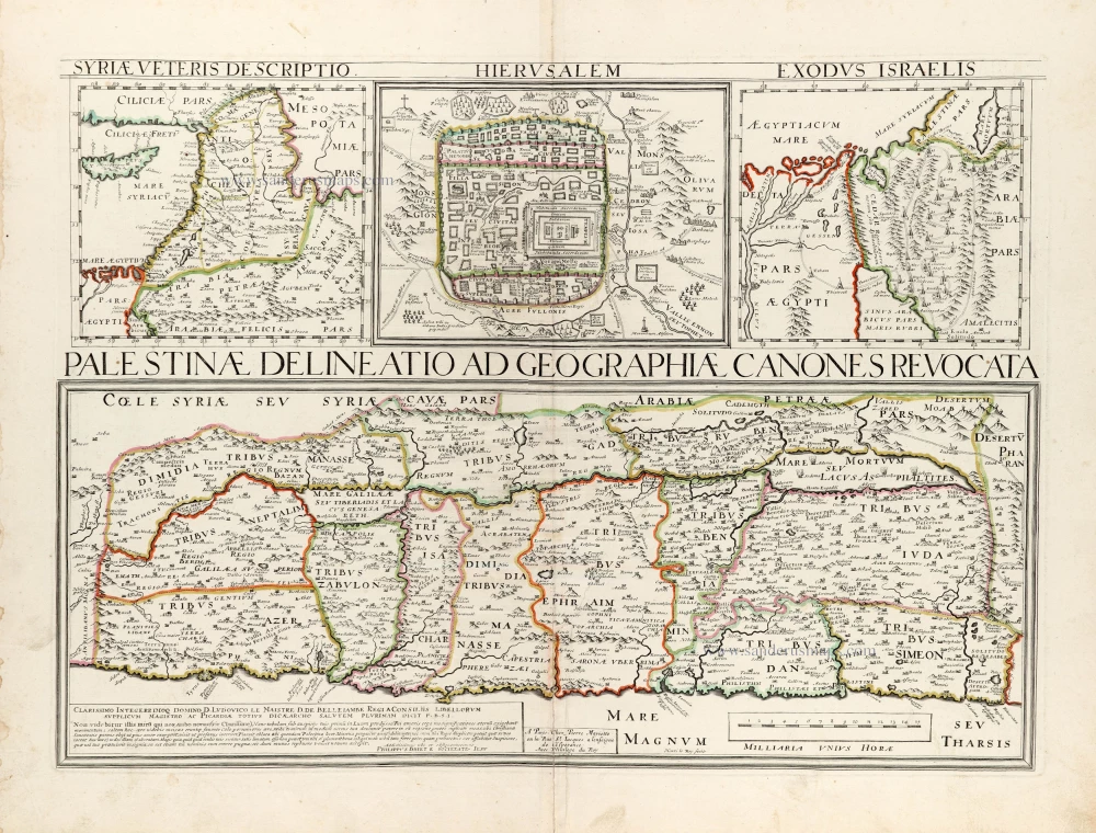
Palestinae Delineatio Ad Geographiae Canones Revocata. 1641
Holy Land - Jerusalem by Philippe Briet, published by Pierre Mariette.
[Item number: 30056]
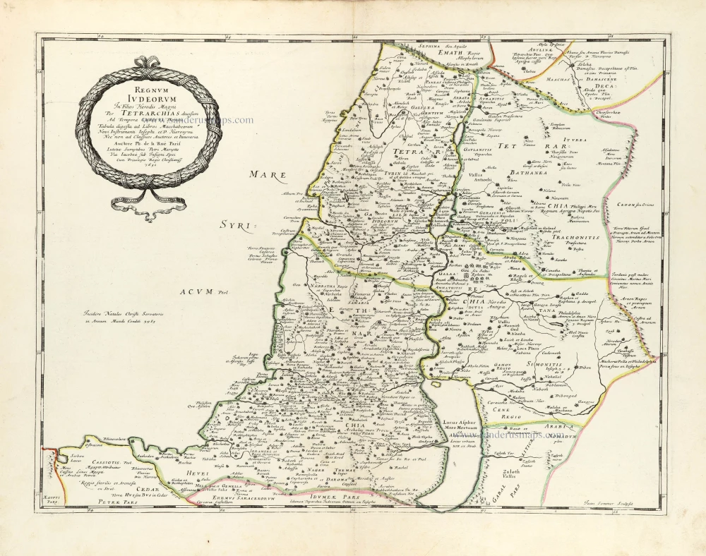
Regnum Iudeorum In Filios Herodis Magni. 1651
Historic map of the Kingdom of Judea in the time of Christ, by Philippe de la Rue, published by Pierre Mariette.
[Item number: 30060]
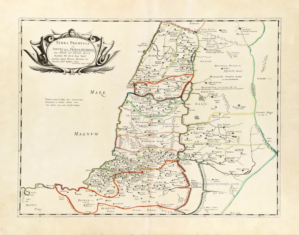
Terra Promissa in Sortes seu Tribus XII Distincta. 1651
The Promised Land divided among the 12 Tribes, by Philippe de la Rue, published by Pierre Mariette.
[Item number: 30061]
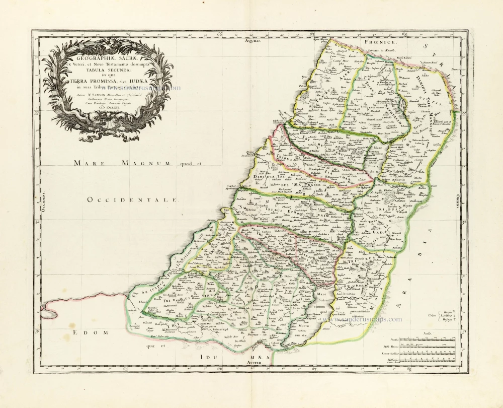
Geographiae Sacrae ex Veteri et Novo Testamento desumptae Tabula Secunda: in qua Terra Promissa, sive Iudaea in suas Tribus Partesq, distincta. 1665
Holy Land by Nicolas Sanson.
[Item number: 30105]
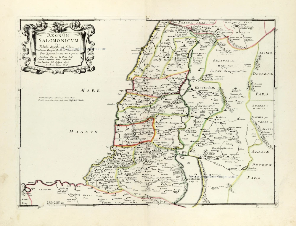
Regnum Salomonicum Seu Tabula digesta ad Libros Judicum, Regum, Paral. et Prophetarum. 1651
Historic map of the Kingdom of Solomon divided into 12 provinces, by Philippe de la Rue, published by Pierre Mariette.
[Item number: 30106]
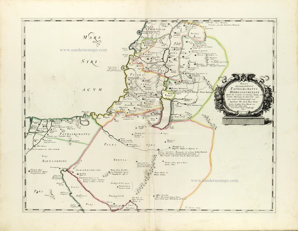
Pinax Geogpaphicus [sic] Patriarchatus Hierosolymitani [...] 1651
The Patriarchate of Jerusalem, by Philippe de la Rue, published by Pierre Mariette.
[Item number: 30120]
Superb old colouring, heightened with gold.
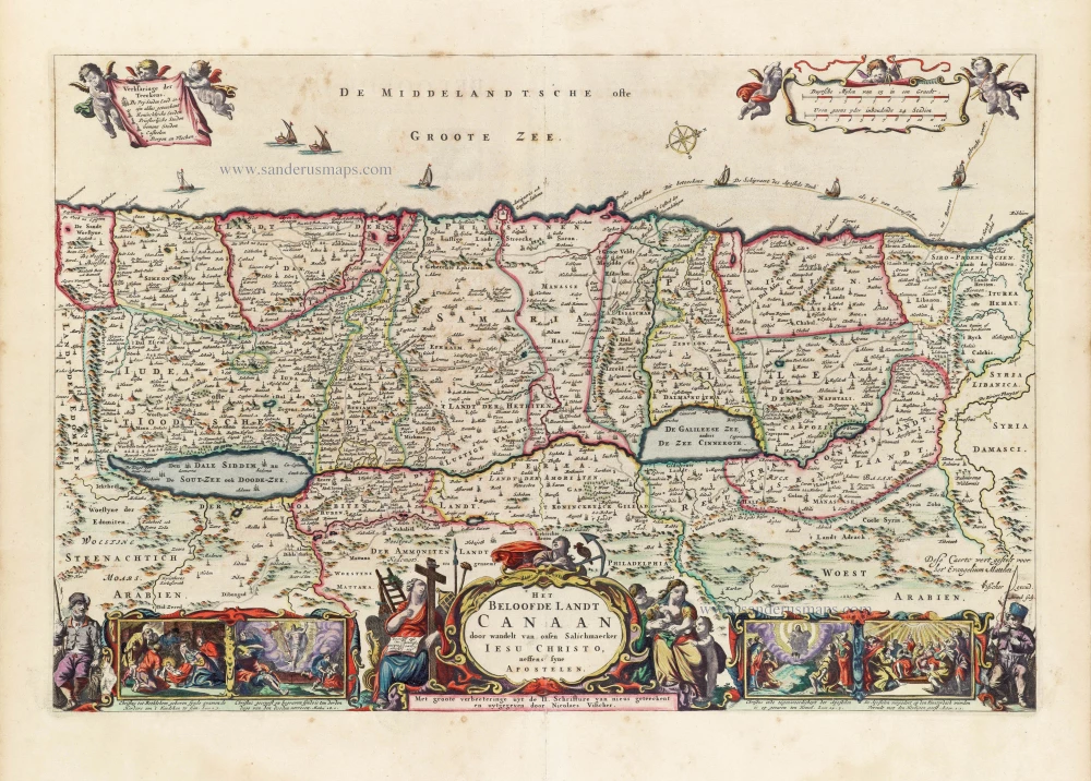
Het Beloofde Landt Canaan door wandelt van onsen Salichmaeker Iesu Christo, neffens syne Apostelen. 1663
Holy Land by Nicolaas Visscher.
[Item number: 30535]
Superb old colouring, heightened with gold.
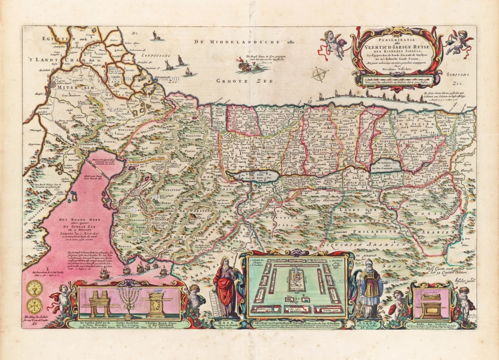
Perigrinatie ofte Veertigh-Iarige Reyse der Kinderen Israëls. 1663
Holy Land, by Nicolaes Visscher I.
[Item number: 30538]
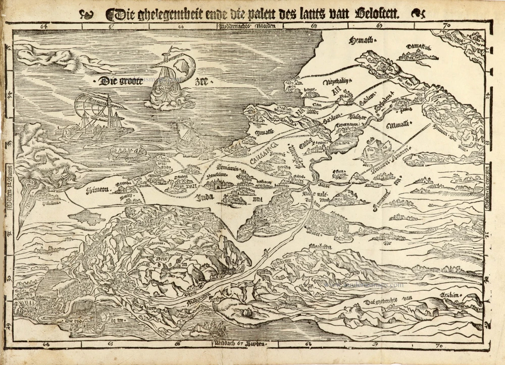
Holy Land map from the very rare van Liesveldt Bible
Die ghelegentheit ende die palen des lants van Beloften. 1532-1560
Holy Land by van Jacob van Liesveldt.
[Item number: 30549]
Terra Sancta quae in Sacris Terra Promissionis olim Palestina. 1645
Holy Land, by Willem Blaeu.
[Item number: 30914]
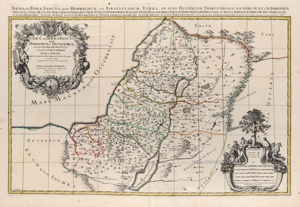
Iudaea seu Terra Sancta quae Hebraeorum sive Israelitarum in suas duodecim Tribus divisa; secretis ab invicem Regnis Iuda et Israel. 1692
Holy Land by N. Sanson, so-called published by Hubert Jaillot. (Pirated edition by Pierre Mortier).
[Item number: 31200]

Tabula Cananaeae prout tempore Christi et Apostolorum divisa fuit 1618
Holy Land by Petrus Bertius, published by Jodocus Hondius II.
[Item number: 32140]
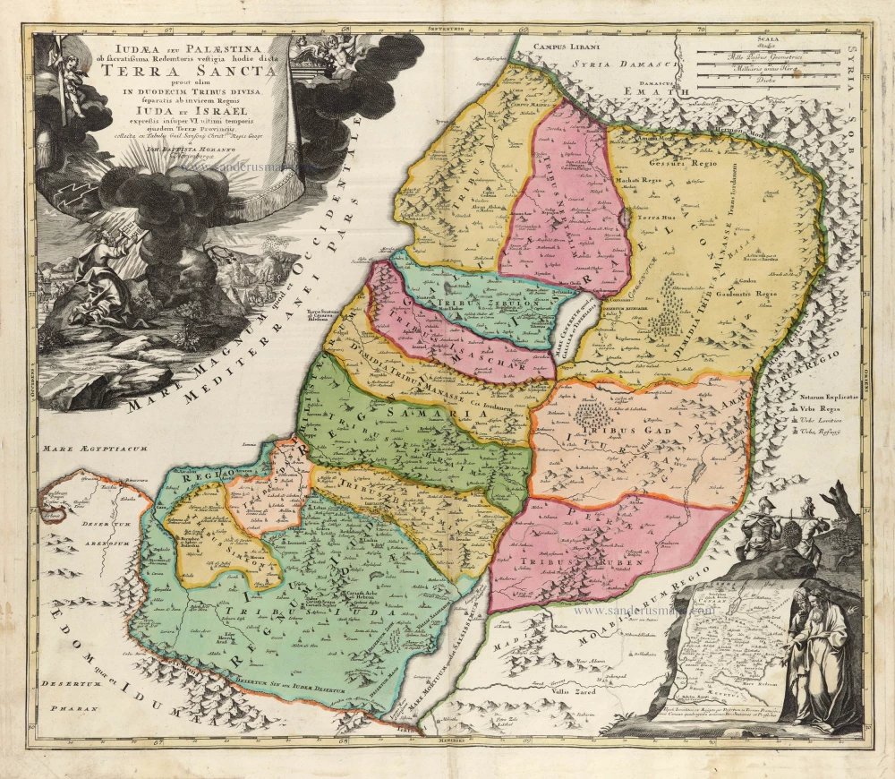
Iudaea seu Palaestina ob Sacratißima Redemtoris vestigia hodie dicta Terra Sancta prout olim in Duodecim Tribus Divisa separatis ab Invicem Regnis Iuda et Israel expreßis insuper VI ultimi temporis ejusdem Terrae Procinciis. c. 1720
Holy Land, by J.B. Homann.
[Item number: 32192]
Terra Sancta sive Promissionis, olim Palestina, in duo divisa Regna, Israel, et Iuda, et in sex subdivisa Provincias ... 1687
Holy Land, by Guillaume Sanson, adapted by Giacomo Cantelli da Vignola, and published by Giovanni de Rossi.
[Item number: 32957]
new