
Philippines by Antonio Zatta. 1779-1785

Antonio Zatta (ca. 1722-1804)
Antonio Zatta was an influential Italian cartographer and publisher based in Venice during the 18th century. As one of the last great mapmakers of the Italian Enlightenment, Zatta played a crucial role in preserving and advancing the art of cartography at a time when Venice's status as a centre for mapmaking was in decline.
Little is known about his early life, but Zatta established himself as a prolific publisher and printer, producing a wide range of works including atlases, city plans, and historical maps. His most celebrated achievement is the Atlante Novissimo, published between 1775 and 1785. This monumental four-volume atlas is considered one of the finest Italian cartographic productions of its time. It combined contemporary geographical knowledge with elegant artistry, featuring detailed hand-coloured maps, elaborate title cartouches, and decorative embellishments characteristic of the late Baroque style.
Zatta’s work is notable for incorporating the latest geographical discoveries alongside classical and historical information, reflecting the Enlightenment's emphasis on reason, exploration, and empirical knowledge. He published maps covering all parts of the known world, including detailed representations of Europe, the Americas, and Asia, often updating older cartographic models with new data from explorers and diplomats.
Among his notable contributions is one of the earliest printed maps depicting the newly independent United States after the American Revolutionary War. Zatta's 1778 map, "Gli Stati Uniti della America Settentrionale," adapted English and French sources, marking a significant moment in the cartographic recognition of the United States.
Antonio Zatta's legacy endures through the beauty and precision of his maps, which continue to be prized by collectors and historians alike for their artistic merit and historical value. His works offer a window into the geographical understanding and visual culture of the 18th century, securing his place among the notable figures of cartographic history.
Isole Filippine.
Item Number: 31559 Authenticity Guarantee
Category: Antique maps > Asia > Southeast Asia
Philippines, by Antonio Zatta.
Title: Isole Filippine.
Venezia 1785 | presso Antonio Zatta e Figli.
Cum Privilegio dell' Eccino Senato.
Oriented to the north.
Date: 1779-1785.
Copper engraving, printed on paper.
Image size: 405 x 315mm (16 x 12½ inches).
Sheet size: 535 x 400mm (21 x 15¾ inches).
Verso: Blank.
Condition: excellent.
Condition Rating: A+
From: Atlante novissimo, illustrato ed accresciuto sulle osservazioni, e scoperte fatte dai più celebri e più recenti geografi, che ora per la prima volta si produce. Venice, Antonio Zatta, 1779-1785.
Antonio Zatta (ca. 1722-1804)
Antonio Zatta was an influential Italian cartographer and publisher based in Venice during the 18th century. As one of the last great mapmakers of the Italian Enlightenment, Zatta played a crucial role in preserving and advancing the art of cartography at a time when Venice's status as a centre for mapmaking was in decline.
Little is known about his early life, but Zatta established himself as a prolific publisher and printer, producing a wide range of works including atlases, city plans, and historical maps. His most celebrated achievement is the Atlante Novissimo, published between 1775 and 1785. This monumental four-volume atlas is considered one of the finest Italian cartographic productions of its time. It combined contemporary geographical knowledge with elegant artistry, featuring detailed hand-coloured maps, elaborate title cartouches, and decorative embellishments characteristic of the late Baroque style.
Zatta’s work is notable for incorporating the latest geographical discoveries alongside classical and historical information, reflecting the Enlightenment's emphasis on reason, exploration, and empirical knowledge. He published maps covering all parts of the known world, including detailed representations of Europe, the Americas, and Asia, often updating older cartographic models with new data from explorers and diplomats.
Among his notable contributions is one of the earliest printed maps depicting the newly independent United States after the American Revolutionary War. Zatta's 1778 map, "Gli Stati Uniti della America Settentrionale," adapted English and French sources, marking a significant moment in the cartographic recognition of the United States.
Antonio Zatta's legacy endures through the beauty and precision of his maps, which continue to be prized by collectors and historians alike for their artistic merit and historical value. His works offer a window into the geographical understanding and visual culture of the 18th century, securing his place among the notable figures of cartographic history.
Related items

Carte du Canal des Iles Philippines par lequel Passe le Galion de Manille et les Iles Voisines de ce Canal. 1749
Philippines by Bonne Rigobert
[Item number: 26611]
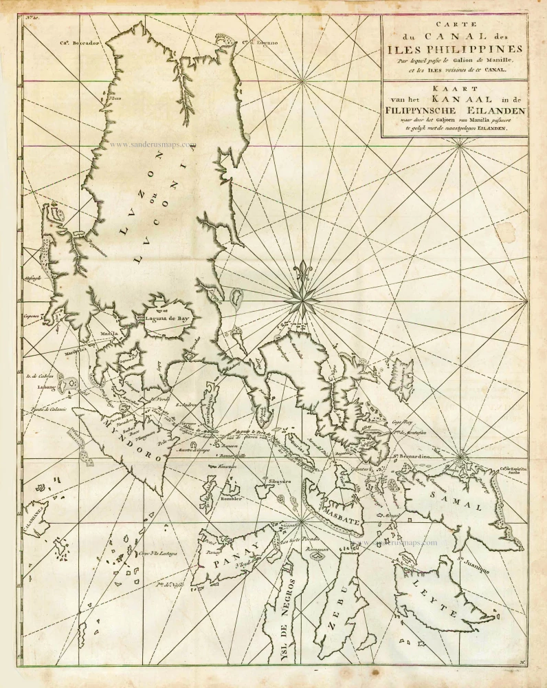
Carte du Canal des Iles Philippines par lequel Passe le Galion de Manille et les Iles Voisines de ce Canal. - Kaart van het Kanaal in de Filippynsche Eilanden waar door het Galjoen van Manilla passeert, tegelijk met de naast gelegen Eilanden. 1748
The Philippines, by George Anson.
[Item number: 27036]
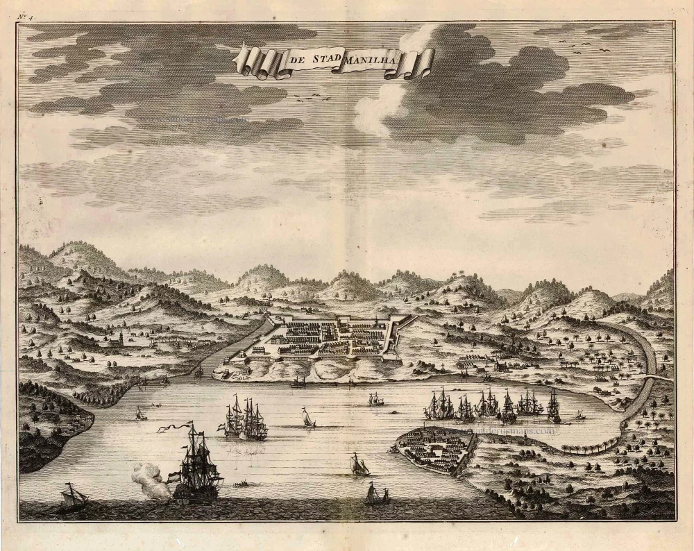
De Stad Manilha. 1726
Philippines - Manilla by François Valentyn (Valentijn)
[Item number: 27894]

Lucon of Luconia. 1726
Philippines, by Valentyn François
[Item number: 27895]

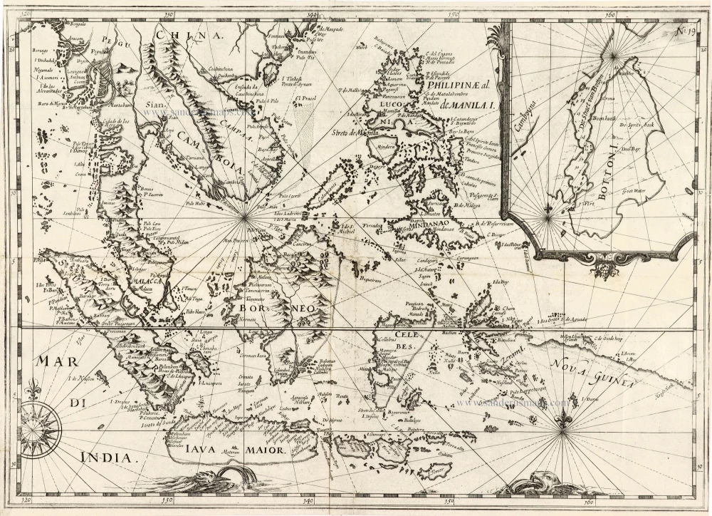
Typus Freti Manilensis. - Détroit de Manilles. 1725
Philippines - Manila Strait by René Augustin Constantin de Renneville.
[Item number: 28370]
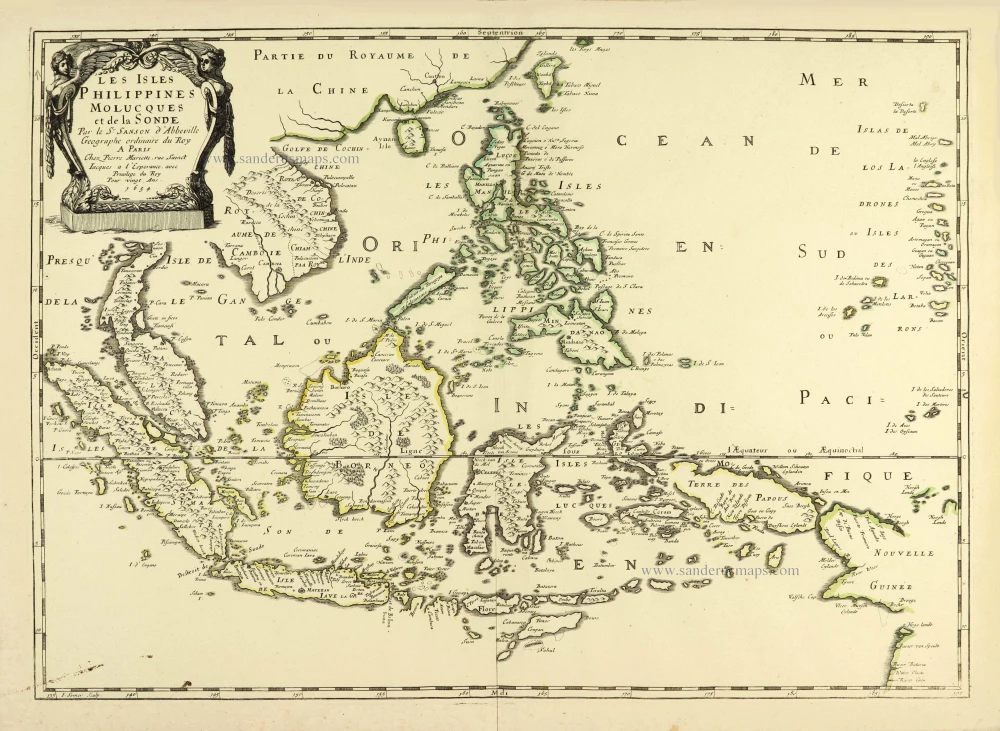
Les Isles Philippines Molucques et de la Sonde. 1658
Southeast Asia par Nicolas Sanson.
[Item number: 28378]
Rare
[No title] - 'Mar di India'. 1645
East Indies by van Spilbergen Joris.
[Item number: 30057]
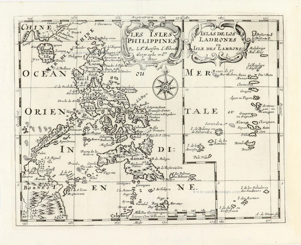
Les Isles Philippines [on sheet with] Islas de los Ladrones ou Isle des Larrons. 1747-74
Philippines, by Nicolas Sanson, published by Prevost d'Exiles.
[Item number: 30304]
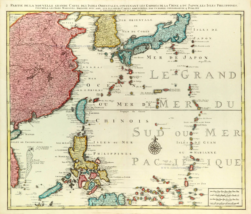
Partie de la Nouvelle Grande Carte des Indes Orientales Contenant les Empires de la Chine, du Japon, les Isles Philippines, Couchin, & les Isles Marianes, 1792
East Asia (Japan - Philippines) by J.B. Elwe.
[Item number: 31803]

Carte des Isles Philippines Celebes et Moluqes. 1747
Philippines, Moluccas, Borneo, and Sulawesi after J.N. Bellin, published by A.F. Prévost.
[Item number: 31881]