
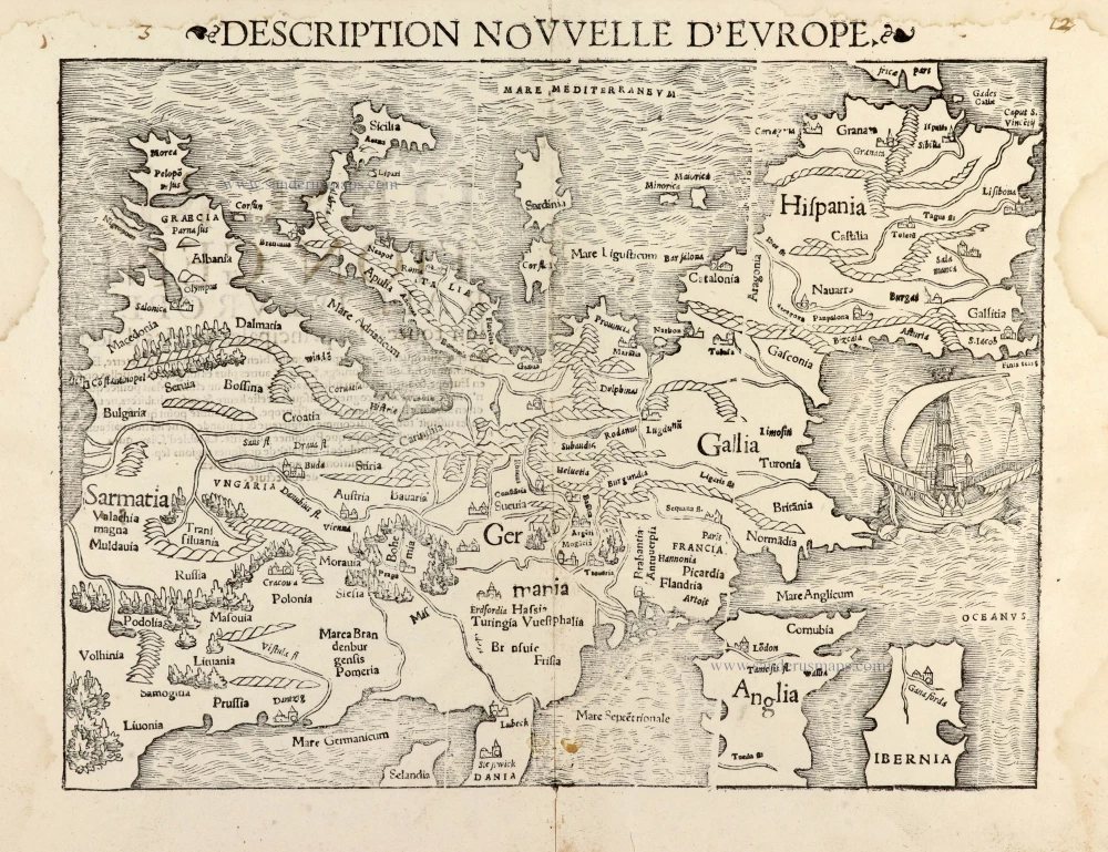
Scarce woodcut map
Europe, by François de Belleforest. 1575

The Cosmographie Universelle of F. de Belleforest was published in a shared edition by Nicolas Chesneau and Michel Sonnius. The objective of the two partners was to reprint Sébastien Münster's Cosmographie in French. Münster's work, published in Basel from 1544, had indeed been a great success and had known multiple reissues. It had been published in French in 1552, but Chesneau and Sonnius, noting that Münster had mainly treated his own country, Germany, wanted to satisfy the tastes of their compatriots more.
They appealed for the text of the work to François de Belleforest (1530-1583). Belleforest probably helped Chesneau and Sonnius in their quest for new city plans.
Belleforest's Cosmographie is presented in two parts, the first of which is divided into two volumes; each of the three volumes has its own title. Some copies bear the imprint of Chesneau, and others that of Sonnius.
Of the 163 plates in the Cosmographie, only 49 are copied from the work of Sebastian Münster. Little is known about the engravers of the Cosmographie. The name of Cruche appears only once, at the bottom of the plate of Paris. Raymont Rancurel is the second known engraver in the Cosmographie. In 1572 appeared the first volume of the Civitates Orbis Terrarum of Braun and Hogenberg. Twenty of these plates were copied by the Cosmographie of Belleforest. The later volumes of the Civitates, on the other hand, borrowed eleven cities from Belleforest's work. From the Theatrum Orbis Terrarum of Abraham Ortelius (1570), Chesneau and Sonnius have retained more modern maps than those of Münster. Other plans have been copied from the Plantz and Pourtraitz by Antoine Du Pinet or from the small maps of Camocio.
Europae. [Above the map :] La Carte d'Europe.
Item Number: 27270 Authenticity Guarantee
Category: Antique maps > Europe > Europe Continent
Old, antique map of Europe, by François de Belleforest.
Title: Europae. [Above the map :] La Carte d'Europe.
Date of the first edition: 1575.
Date of this map: 1575.
Woodcut, printed on paper.
Size (not including margins): 340 x 465mm (13.39 x 18.31 inches).
Verso: Blank.
Condition: Folds as issued, light stain in the middle.
Condition Rating: A+.
From: La Cosmographie Universelle de tout le Monde. Paris, Nicolas Chesneau - Michel Sonnius, 1575. (= French edition of Münster's Cosmographia).
The Cosmographie Universelle of F. de Belleforest was published in a shared edition by Nicolas Chesneau and Michel Sonnius. The objective of the two partners was to reprint Sébastien Münster's Cosmographie in French. Münster's work, published in Basel from 1544, had indeed been a great success and had known multiple reissues. It had been published in French in 1552, but Chesneau and Sonnius, noting that Münster had mainly treated his own country, Germany, wanted to satisfy the tastes of their compatriots more.
They appealed for the text of the work to François de Belleforest (1530-1583). Belleforest probably helped Chesneau and Sonnius in their quest for new city plans.
Belleforest's Cosmographie is presented in two parts, the first of which is divided into two volumes; each of the three volumes has its own title. Some copies bear the imprint of Chesneau, and others that of Sonnius.
Of the 163 plates in the Cosmographie, only 49 are copied from the work of Sebastian Münster. Little is known about the engravers of the Cosmographie. The name of Cruche appears only once, at the bottom of the plate of Paris. Raymont Rancurel is the second known engraver in the Cosmographie. In 1572 appeared the first volume of the Civitates Orbis Terrarum of Braun and Hogenberg. Twenty of these plates were copied by the Cosmographie of Belleforest. The later volumes of the Civitates, on the other hand, borrowed eleven cities from Belleforest's work. From the Theatrum Orbis Terrarum of Abraham Ortelius (1570), Chesneau and Sonnius have retained more modern maps than those of Münster. Other plans have been copied from the Plantz and Pourtraitz by Antoine Du Pinet or from the small maps of Camocio.
Related items
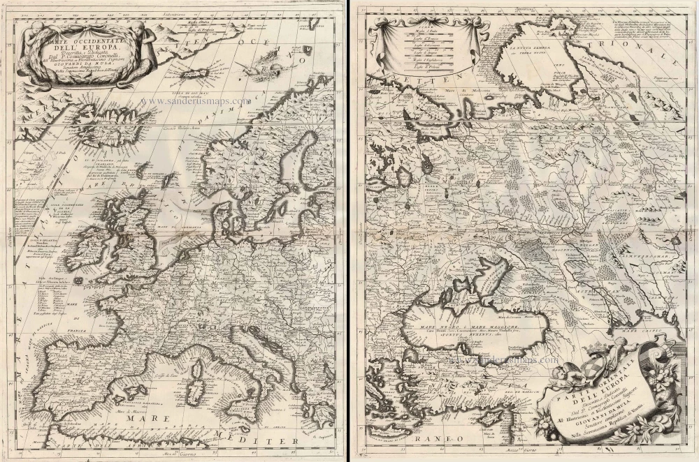
Parte Occidentale dell'Europa ... [in set with] Parte Orientale dell'Europa ... 1691
Europe, by V.M. Coronelli.
[Item number: 23186]

Europa Pars Tenet haec Mundi Reliquas Celeberrima Partes c. 1730.
Europe by G.& L. Valk.
[Item number: 24536]

Europa. 1600
Europe, by Matthias Quad.
[Item number: 26666]
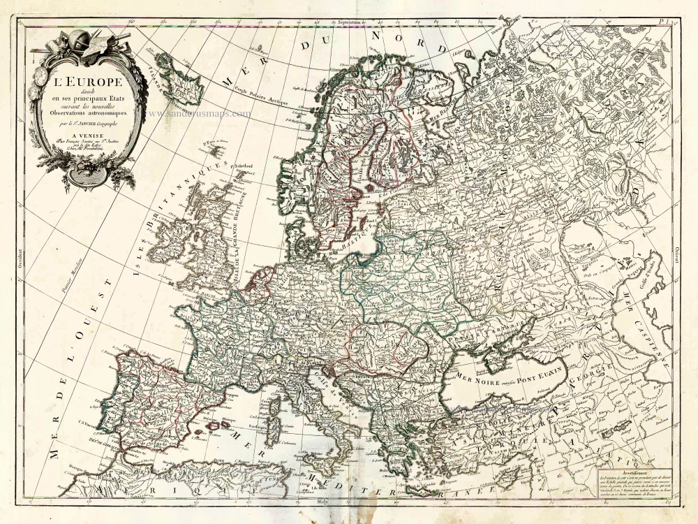
L'Europe Divisee en ses Principaux Etats. 1776-79
Europe, by Francesco Santini.
[Item number: 26947]

Europa delineata et recens edita. 1683-1696
Europe by Nicolaas Visscher II.
[Item number: 28712]

Europa Vetus. 1667-69
Ancient Europe by Nicolas & Guillaume Sanson.
[Item number: 30000]
Description Nouvelle d'Europe. 1568
Europe by Sebastian Münster
[Item number: 30523]

Nobilis Hannoniae Com. Descriptio. 1634
Hainaut by Petrus Kaerius (Pieter Van den Keere), published by Claes Jansz. Visscher.
[Item number: 30736]

Europae. 1612
Europe, by Abraham Ortelius.
[Item number: 30944]

Rare
Nova Totius Europae Tabula ex magnis Gerardi de Iudaeis P. desumpta 1593
Europe by Cornelis de Jode
[Item number: 30946]

L'Europe Divisée Suivant l'Estendue de ses Principaux Estats subdivisés en leurs principales Provinces. 1692
Europe, by N. Sanson, so-called published by Hubert Jaillot. (Pirated edition by Pierre Mortier).
[Item number: 31138]

Europa Christiani Orbis Domina in sua Imperia, Regna, et Styatus exacte divisa c. 1720
Europe by J.B. Homann
[Item number: 32098]
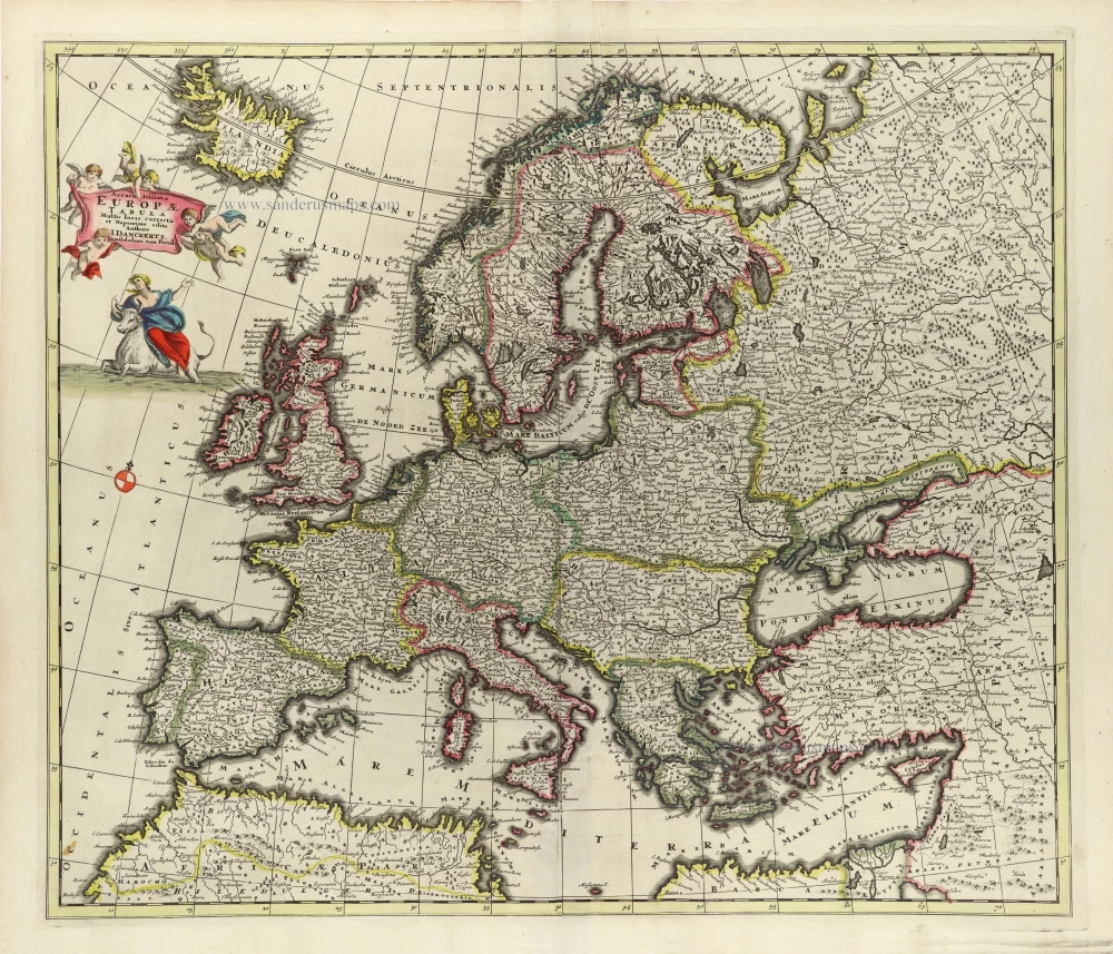
Accuratissima Europae Tabula. 1696-1713
Europe by J. Danckerts.
[Item number: 32457]

L' Europa. 1677
Europe by Giovanni De Rossi, after Nicolas Sanson.
[Item number: 32886]

Europa, ad Magnae Europae Gerardi Mercatoris P. Imitationem, Rumoldi Mercatoris F. Cura Edita, Seruato Tamen Initio Longitudinis ex Ratione Magnetis, quod Pater in Magna sua Universali Posuit. 1613
Europe by Gerard Mercator.
[Item number: 32928]

Scarce
Nova Europa Descriptio. 1689-90
Europe by Frederick de Wit
[Item number: 32974]

Carte de L'Europe, corrigée et augmentée dessus toutes les autres cy devant faictes c. 1630-1650
Europe by Petrus Bertius, published by Melchior Tavernier.
[Item number: 33121]
new