
Liège - Namur, by Frederick de Wit. c. 1705-06

Frederick de Wit (1630-1706)
The engraver and map-seller, Frederick de Wit, was born in Gouda (Netherlands) in 1630 as a son of Hendrick Fredericksz de Wit. Through his marriage with Maria van der Waag of Amsterdam in 1661, he obtained citizenship of the city where he had been working since 1648 and where he became one of the most famous engravers of maps of the second half of the 17th century. Although De Wit was a Catholic, which meant that he was not favoured at the time by the city council, he was awarded the honour of being listed as one of the "excellent citizens" on the roll of the city council in the years 1694-1704. However, his name was not written in the Guild of St. Luke book before 1664. At that time, he lived on the Kalverstraat "in de Witte Pascaert", where he stayed until his death in 1706. His earliest dates on maps engraved are 1659 (Regni Daniae) and 1660 (World map).
Frederick de Wit published several world atlases, a sea atlas, and an atlas of the Netherlands.
The dating of the maps is difficult. However, as a privilege was granted in 1689, the annotation 'cum privilegio' marks an edition after 1688.
Around 1700, Frederick de Wit entered the market with a town atlas. He produced two volumes with a total of 260 plans and views. Most were printed from plates used for Janssonius and Blaeu town atlases.
After he died in 1706, his widow continued the shop until 1709. The plates and stock of De Wit's atlas were sold to Covens & Mortier in 1710, who sold the atlas for an extended period.
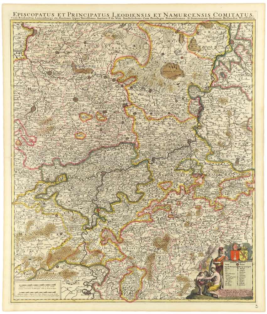
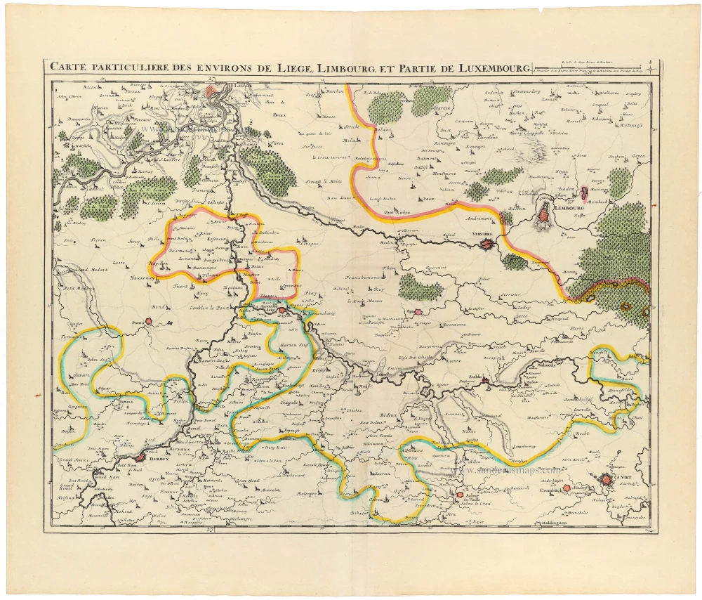
Episcopatus et Principatus Leodiensis et Namurcensis Comitatus, Cum Brabantiae, Luxemburgi etc.
Item Number: 33158 Authenticity Guarantee
Category: Antique maps > Europe > Belgium
Liège - Namur, by Frederick de Wit.
Title: Episcopatus et Principatus Leodiensis et Namurcensis Comitatus, Cum Brabantiae, Luxemburgi etc.
Finitimus typus Novissimus Auctore F. de Witt Amstelodami Cum Privilegio Potentissimor: D: Dominorum Ordinium Hollandiae Westfrisiaeq.
Date of the first edition: c. 1705.
Date of this map: c. 1705-06.
Copper engraving, printed on paper.
Image size: 590 x 505mm (23¼ x 20 inches).
Sheet size: 630 x 540mm (24¾ x 21¼ inches).
Verso: Blank.
Condition: Original coloured, excellent.
Condition Rating: A+.
From: Composite Atlas by F. De Wit, c. 1705-06.
Frederick de Wit (1630-1706)
The engraver and map-seller, Frederick de Wit, was born in Gouda (Netherlands) in 1630 as a son of Hendrick Fredericksz de Wit. Through his marriage with Maria van der Waag of Amsterdam in 1661, he obtained citizenship of the city where he had been working since 1648 and where he became one of the most famous engravers of maps of the second half of the 17th century. Although De Wit was a Catholic, which meant that he was not favoured at the time by the city council, he was awarded the honour of being listed as one of the "excellent citizens" on the roll of the city council in the years 1694-1704. However, his name was not written in the Guild of St. Luke book before 1664. At that time, he lived on the Kalverstraat "in de Witte Pascaert", where he stayed until his death in 1706. His earliest dates on maps engraved are 1659 (Regni Daniae) and 1660 (World map).
Frederick de Wit published several world atlases, a sea atlas, and an atlas of the Netherlands.
The dating of the maps is difficult. However, as a privilege was granted in 1689, the annotation 'cum privilegio' marks an edition after 1688.
Around 1700, Frederick de Wit entered the market with a town atlas. He produced two volumes with a total of 260 plans and views. Most were printed from plates used for Janssonius and Blaeu town atlases.
After he died in 1706, his widow continued the shop until 1709. The plates and stock of De Wit's atlas were sold to Covens & Mortier in 1710, who sold the atlas for an extended period.
Related items

Leodiensis Dioecesis Typus. 1598
Liège, by Abraham Ortelius.
[Item number: 6346]

Leodiensis Episcopatus in omnes subjacentes Provincias distincte divisus. 1683-1696
Liège, by N. Visscher II.
[Item number: 10967]

Hannonia Namurcum Comitatus. 1619
Hainaut - Namur, by G. Mercator
[Item number: 12182]

Leodiensis Episcopatus pars Media 1683-1696
Liège, by N. Visscher.
[Item number: 13094]

Comitatuum Hannoniae Et Namurci Descriptio 1640-43
Hainaut - Namur, by Blaeu W. & J.
[Item number: 13985]

Namurcum Comitatus. Na 1612.
Namur, by Ortelius A. - Galle Th.
[Item number: 15490]

Namurcum, Comitatus 1612
Namur by Abraham Ortelius.
[Item number: 22940]

Carte Particulière des environs de Liège, Limbourg et Partie de Luxembourg. 1721-41
Liège, by Covens & Mortier.
[Item number: 23682]

Comitatus Namurci 1683-1696
Namur, by N. Visscher
[Item number: 24453]

Tractus Inter Sabim Et Mosam 1683-1696
Namur by Visscher N. II.
[Item number: 24460]

Plan qui représente les Environs et la Circonvallation de Namur, du 4. Septembre au 6. Octobre. Avec les differentes positions de l'Armée du Roy et de celle des Alliés, depuis le 30. Juillet jusqu'au 19. Aoust 1746. Levé Geometriquement. 1746
Military manuscript map of the western vicinity of Namur.
[Item number: 24865]

Hannonia. Namurcum Comitatus 1623
Hainaut and Namur, by G. Mercator.
[Item number: 24919]

Nieuwe Kaart van 't Graafschap Namen, met een groot gedeelte van 't Hertogdom Brabant, ... 1720-30
Namur by N. Visscher II, published by P. Schenk.
[Item number: 25921]

Leodiensis Dioecesis Typus. 1623
Liège, by Jodocus Hondius.
[Item number: 27964]

Leodiensis Dioecesis Typus. After 1612
Liège, by Abraham Ortelius.
[Item number: 28111]

In luxury colouring.
La Ville de Namur avec son Chateau et autres Fortifications. - De sterke Stadt Namen met syn Casteel en andere Fortificatien. 1721-41
Namur by Covens & Mortier.
[Item number: 29495]

Carte contenant le Duché de Limbourg et partie du Diocèse de Liège. c. 1709
Limburg - Liège by Pierre Husson.
[Item number: 29590]

Leodiensis Dioecesis. 1643
Diocese of Liège, by Willem Blaeu.
[Item number: 29933]

Dioecesis Leodiensis Accurata Tabula. 1653
Diocese of Liège by Johannes Janssonius.
[Item number: 30372]

Namurcum. 1617
Namur by Pieter Van den Keere (Petrus Kaerius).
[Item number: 30654]

Leodiensis Dioecesis Typus. c. 1610-1650
Liège, by Jodocus Hondius.
[Item number: 31214]

Dioecesis Leodiensis Accurata Tabula. c. 1630-1650
Diocese of Liège by Henricus Hondius.
[Item number: 31215]
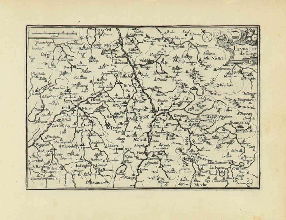
L'Evesché de Liège. 1633
Liège by Christophe Tassin.
[Item number: 31935]
Carte Particulière des environs de Liège, Limbourg, et partie de Luxembourg. 1712
Liège - Verviers - Durbuy, by E.H. Fricx.
[Item number: 32829]