
Cordoba, by Georg Braun and Frans Hogenberg. c. 1625


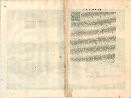
COMMENTARY BY BRAUN: "This is a very noble and extremely interesting city. [...] But in particular the soil on the northern side, where the mountains begin, is so fertile that it produces not only oil, wine, cherries, figs, peaches, plums, bitter oranges, lemons and similar delicious fruits, but also many beautiful wild trees grow on the highest peaks and precipitous rocks, as if out of the stone, especially of the kind that is called lotos in Latin, whose fruit is so sweet that anyone who has eaten of it can no longer resist the desire to eat more."
This slightly elevated view from the southeast shows the city before the backdrop of the Sierra de Cordoba. In the foreground the 14th-century Torre de la Calahorra (D) can be seen, behind which is the Roman bridge (H) that crosses the Quadalquivir and leads to the cathedral (A). Built in the 8th century as a mosque and enlarged in the 9th/10th centuries, it was converted into a Christian church after the Spanish recaptured the city. On the left is the Alcazar de los Reyes Cristianos (G), begun under Alfonso XI in 1328, the residence of the Spanish kings; from the end of the 16th century the Inquisition had its seat here. Once the capital of the wealthy Roman province of Baetica, Cordoba was conquered by the Moors in AD 711 and as the residence of the Umayyad Caliphate it was one of the biggest cities in the world at that time. In 1236 Cordoba became Christian again in the course of the Reconquista. (Taschen)
Braun G. & Hogenberg F. and the Civitates Orbis Terrarum.
The Civitates Orbis Terrarum, also known as the 'Braun & Hogenberg', is a six-volume town atlas and the most excellent book of town views and plans ever published: 363 engravings, sometimes beautifully coloured. It was one of the best-selling works in the last quarter of the 16th century. Georg Braun, a skilled writer, wrote the text accompanying the plans and views on the verso. Many plates were engraved after the original drawings of a professional artist, Joris Hoefnagel (1542-1600). The first volume was published in Latin in 1572 and the sixth in 1617. Frans Hogenberg, a talented engraver, created the tables for volumes I through IV, and Simon van den Neuwel made those for volumes V and VI. Other contributors were cartographers Daniel Freese and Heinrich Rantzau, who provided valuable geographical information. Works by Jacob van Deventer, Sebastian Münster, and Johannes Stumpf were also used as references. Translations appeared in German and French, making the atlas accessible to a broader audience.
Since its original publication of volume 1 in 1572, the Civitates Orbis Terrarum has left an indelible mark on the history of cartography. Seven more editions followed the first volume in 1575, 1577, 1582, 1588, 1593, 1599, and 1612. Vol.2, initially released in 1575, saw subsequent editions in 1597 and 1612. The subsequent volumes, each a treasure trove of historical insights, graced the world in 1581, 1588, 1593, 1599, and 1606. The German translation of the first volume, a testament to its widespread appeal, debuted in 1574, followed by the French edition in 1575.
Several printers were involved: Theodor Graminaeus, Heinrich von Aich, Gottfried von Kempen, Johannis Sinniger, Bertram Buchholtz, and Peter von Brachel, all of whom worked in Cologne.
Georg Braun (1541-1622)
Georg Braun, the author of the text accompanying the plans and views in the Civitates Orbis Terrarum, was born in Cologne in 1541. After his studies in Cologne, he entered the Jesuit Order as a novice, indicating his commitment to learning and intellectual pursuits. In 1561, he obtained his bachelor's degree; in 1562, he received his Magister Artium, further demonstrating his academic achievements. Although he left the Jesuit Order, he continued his studies in theology, gaining a licentiate in theology. His theological background likely influenced the content and tone of the text in the Civitates Orbis Terrarum, adding a unique perspective to the work.
Frans Hogenberg (1535-1590)
Frans Hogenberg was a Flemish and German painter, engraver, and mapmaker. He was born in Mechelen as the son of Nicolaas Hogenberg.
By the end of the 1560s, Frans Hogenberg was employed upon Abraham Ortelius's Theatrum Orbis Terrarum, published in 1570; he is named an engraver of numerous maps. In 1568, he was banned from Antwerp by the Duke of Alva and travelled to London, where he stayed a few years before emigrating to Cologne. He immediately embarked on his two most important works, the Civitates, published in 1572 and the Geschichtsblätter, which appeared in several series from 1569 until about 1587.
Thanks to large-scale projects like the Geschichtsblätter and the Civitates, Hogenberg's social circumstances improved with each passing year. He died as a wealthy man in Cologne in 1590.
Corduba.
Item Number: 16385 Authenticity Guarantee
Category: Antique maps > Europe > Spain and Portugal
Old, antique bird’s-eye view plan of Cordoba, by Georg Braun and Frans Hogenberg.
Title: Corduba.
Date of the first edition: 1617.
Date of this map: c. 1625.
Copper engraving, printed on paper.
Size (not including margins): 335 x 505mm (13.19 x 19.88 inches).
Verso: French text.
Condition: Original coloured, excellent.
Condition Rating: A+.
From: Théatre des Principales Villes de tout l'Univers Vol. VI. c. 1625. (Van der Krogt 4, 41:3.6)
COMMENTARY BY BRAUN: "This is a very noble and extremely interesting city. [...] But in particular the soil on the northern side, where the mountains begin, is so fertile that it produces not only oil, wine, cherries, figs, peaches, plums, bitter oranges, lemons and similar delicious fruits, but also many beautiful wild trees grow on the highest peaks and precipitous rocks, as if out of the stone, especially of the kind that is called lotos in Latin, whose fruit is so sweet that anyone who has eaten of it can no longer resist the desire to eat more."
This slightly elevated view from the southeast shows the city before the backdrop of the Sierra de Cordoba. In the foreground the 14th-century Torre de la Calahorra (D) can be seen, behind which is the Roman bridge (H) that crosses the Quadalquivir and leads to the cathedral (A). Built in the 8th century as a mosque and enlarged in the 9th/10th centuries, it was converted into a Christian church after the Spanish recaptured the city. On the left is the Alcazar de los Reyes Cristianos (G), begun under Alfonso XI in 1328, the residence of the Spanish kings; from the end of the 16th century the Inquisition had its seat here. Once the capital of the wealthy Roman province of Baetica, Cordoba was conquered by the Moors in AD 711 and as the residence of the Umayyad Caliphate it was one of the biggest cities in the world at that time. In 1236 Cordoba became Christian again in the course of the Reconquista. (Taschen)
Braun G. & Hogenberg F. and the Civitates Orbis Terrarum.
The Civitates Orbis Terrarum, also known as the 'Braun & Hogenberg', is a six-volume town atlas and the most excellent book of town views and plans ever published: 363 engravings, sometimes beautifully coloured. It was one of the best-selling works in the last quarter of the 16th century. Georg Braun, a skilled writer, wrote the text accompanying the plans and views on the verso. Many plates were engraved after the original drawings of a professional artist, Joris Hoefnagel (1542-1600). The first volume was published in Latin in 1572 and the sixth in 1617. Frans Hogenberg, a talented engraver, created the tables for volumes I through IV, and Simon van den Neuwel made those for volumes V and VI. Other contributors were cartographers Daniel Freese and Heinrich Rantzau, who provided valuable geographical information. Works by Jacob van Deventer, Sebastian Münster, and Johannes Stumpf were also used as references. Translations appeared in German and French, making the atlas accessible to a broader audience.
Since its original publication of volume 1 in 1572, the Civitates Orbis Terrarum has left an indelible mark on the history of cartography. Seven more editions followed the first volume in 1575, 1577, 1582, 1588, 1593, 1599, and 1612. Vol.2, initially released in 1575, saw subsequent editions in 1597 and 1612. The subsequent volumes, each a treasure trove of historical insights, graced the world in 1581, 1588, 1593, 1599, and 1606. The German translation of the first volume, a testament to its widespread appeal, debuted in 1574, followed by the French edition in 1575.
Several printers were involved: Theodor Graminaeus, Heinrich von Aich, Gottfried von Kempen, Johannis Sinniger, Bertram Buchholtz, and Peter von Brachel, all of whom worked in Cologne.
Georg Braun (1541-1622)
Georg Braun, the author of the text accompanying the plans and views in the Civitates Orbis Terrarum, was born in Cologne in 1541. After his studies in Cologne, he entered the Jesuit Order as a novice, indicating his commitment to learning and intellectual pursuits. In 1561, he obtained his bachelor's degree; in 1562, he received his Magister Artium, further demonstrating his academic achievements. Although he left the Jesuit Order, he continued his studies in theology, gaining a licentiate in theology. His theological background likely influenced the content and tone of the text in the Civitates Orbis Terrarum, adding a unique perspective to the work.
Frans Hogenberg (1535-1590)
Frans Hogenberg was a Flemish and German painter, engraver, and mapmaker. He was born in Mechelen as the son of Nicolaas Hogenberg.
By the end of the 1560s, Frans Hogenberg was employed upon Abraham Ortelius's Theatrum Orbis Terrarum, published in 1570; he is named an engraver of numerous maps. In 1568, he was banned from Antwerp by the Duke of Alva and travelled to London, where he stayed a few years before emigrating to Cologne. He immediately embarked on his two most important works, the Civitates, published in 1572 and the Geschichtsblätter, which appeared in several series from 1569 until about 1587.
Thanks to large-scale projects like the Geschichtsblätter and the Civitates, Hogenberg's social circumstances improved with each passing year. He died as a wealthy man in Cologne in 1590.
Related items
Palacios [on sheet with:] Alcanerilla [and] Cabecas. 1623
Palacios - Alcantarilla - Cabecas by Georg Braun & Frans Hogenberg.
[Item number: 103]
Hardales [on sheet with] Cartama. 1596
Ardales & Cartama by Georg Braun & Frans Hogenberg.
[Item number: 229]

Toletum [on sheet with] Vallisoletum ... Nobilis. Totius Hispania Oppidum 1572-1624
Toledo & Valladolid by Georg Braun & Frans Hogenberg.
[Item number: 2067]

Burgos celebris et antiqua Hispaniae civitas, ... [on sheet with] Sanct. Sebastianum vulgo Donosien ad Occanum ... 1582
Burgos - San Sebastian by Braun & Hogenberg
[Item number: 14159]

Loxa 1593
Loja, by Georg Braun and Frans Hogenberg.
[Item number: 14706]

Alhama 1593
Alhama de Granada by Georg Braun & Frans Hogenberg
[Item number: 14714]

Vegel [on sheet with] Velis Malaga. 1575-1612
Vejer de la Frontera and Vélez-Málaga, by Georg Braun and Frans Hogenberg.
[Item number: 14895]

Granata. 1623
Granada by Georg Braun & Frans Hogenberg.
[Item number: 16665]

Palacios [on sheet with:] Alcanerilla [and] Cabecas. c. 1610
Los Palacios y Villafranca - Las Alcantarillas - Las Cabezas de San Juan, by Georg Braun and Frans Hogenberg.
[Item number: 16715]

Illustris Civitati Conimbriae In Lusitania ad flumen Illundam effigies. 1596-1640
Coimbra by Braun & Hogenberg.
[Item number: 21345]