
Ardales & Cartama by Georg Braun & Frans Hogenberg. 1596
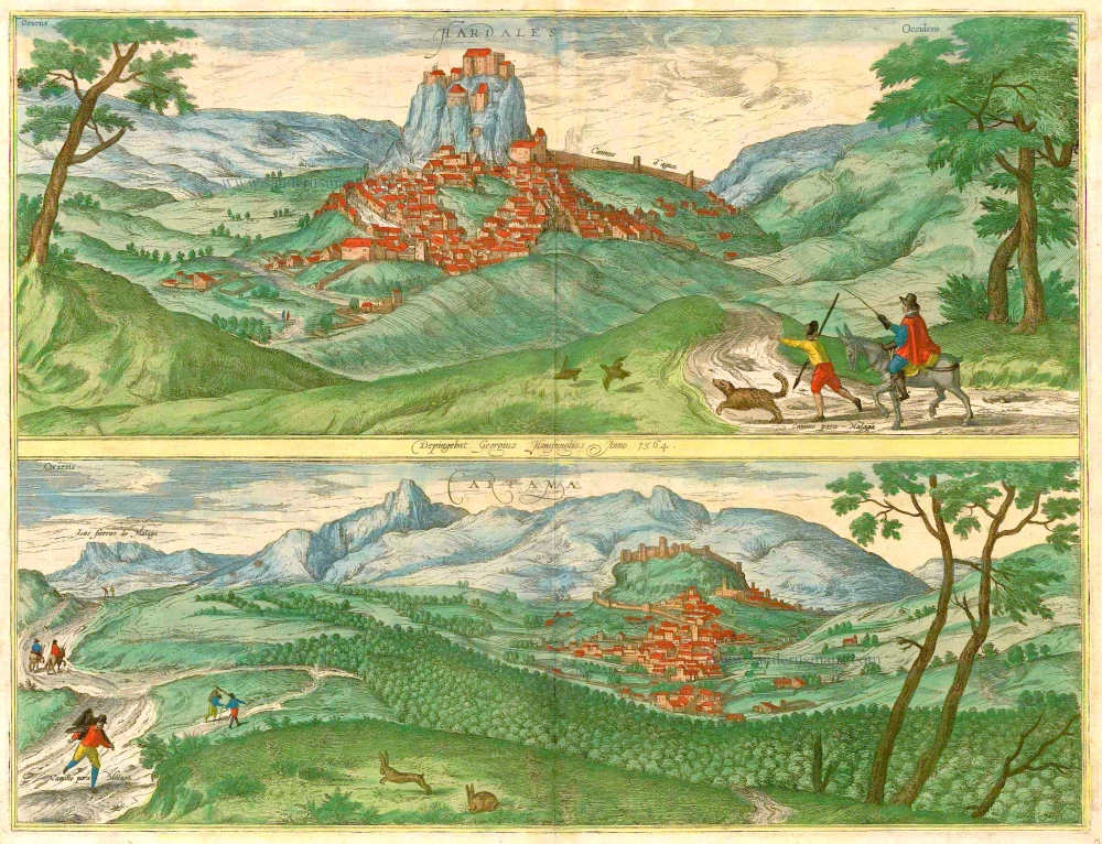
ARDALES
COMMENTARY BY BRAUN: "On a high cliff above Ardales stands a fortress that was built by the Moors in earlier times on the border with Seville. The fortress was later furnished with additional buildings by the Christians, victors over the Moors. There is an irrigation channel here along which clear, pure water is conducted from the neighbouring mountain to the fortress and on to the town and which brings the inhabitants an abundance of water with its many advantages."
The view shows Ardales situated on a tributary of the River Guadalhorce between Ronda and Antequera. High above the town is the fortress, perched on one of the foothills of the Sierra de Peñarruba at an elevation of some 500 m. It was built towards the end of the 9th century by rebellious Moors and served as a stronghold for the insurgents grouped around Umar inbn-Hafsun, who revolted against the Emirate of Córdoba and later converted to Christianity. The revolt ended in AD 928 with the capture of the rebels' headquarters - the nearby fortress of Bobastro - by the eighth Emir of Córdoba, 'Abd ar-Rahman III. After the successful campaign of the Reconquista by Ferdinand III, Ardales found itself on the border between Christian Seville and Moorish Granada and was occupied by both sides alternately, until finally falling to the Christians in 1453/54. It was the latter, in the 15th and 16th centuries, who constructed the irrigation channel (Cannos d'agua, right) that brings water to the city from the nearby Sierra de Alcaparain.
CÁRTAMA
COMMENTARY BY BRAUN: "Cártama lies two miles from Malaga at the foot of a large mountain that runs all the way to the Mediterranean. It is a small town with a fortress and whose inhabitants live from arable farming and cattle breeding. In the vicinity, there are many oaks and trees with walnuts, which are used for ink, for dyeing leather and also for medicines. Capers also grow there in great numbers, which are collected by the common people, taken to the capital of Málaga and from there exported across the sea to the Netherlands and other countries."
The view shows Cártama, which lies west of Málaga. Due to its strategic location on the right bank of the Guadalhorce and along a natural route from the coast into the interior, it was settled early on by the Iberians. Over the following centuries, it was occupied by the Phoenicians and in 195 BC by the Romans, who left many archaeological traces of their 600-year rule. The fortress, originally established by the Iberians and considerably enlarged by the Romans, was rebuilt by the Visigoths. It assumed key importance, however, only after the invasion of the Moors, who in the 10th century gave the castle its present form and for whom it served as one of Málaga's most important defences. It was finally conquered by the Catholic king in 1485. (Taschen)
Braun G. & Hogenberg F. and the Civitates Orbis Terrarum.
The Civitates Orbis Terrarum, also known as the 'Braun & Hogenberg', is a six-volume town atlas and the most excellent book of town views and plans ever published: 363 engravings, sometimes beautifully coloured. It was one of the best-selling works in the last quarter of the 16th century. Georg Braun, a skilled writer, wrote the text accompanying the plans and views on the verso. Many plates were engraved after the original drawings of a professional artist, Joris Hoefnagel (1542-1600). The first volume was published in Latin in 1572 and the sixth in 1617. Frans Hogenberg, a talented engraver, created the tables for volumes I through IV, and Simon van den Neuwel made those for volumes V and VI. Other contributors were cartographers Daniel Freese and Heinrich Rantzau, who provided valuable geographical information. Works by Jacob van Deventer, Sebastian Münster, and Johannes Stumpf were also used as references. Translations appeared in German and French, making the atlas accessible to a broader audience.
Since its original publication of volume 1 in 1572, the Civitates Orbis Terrarum has left an indelible mark on the history of cartography. Seven more editions followed the first volume in 1575, 1577, 1582, 1588, 1593, 1599, and 1612. Vol.2, initially released in 1575, saw subsequent editions in 1597 and 1612. The subsequent volumes, each a treasure trove of historical insights, graced the world in 1581, 1588, 1593, 1599, and 1606. The German translation of the first volume, a testament to its widespread appeal, debuted in 1574, followed by the French edition in 1575.
Several printers were involved: Theodor Graminaeus, Heinrich von Aich, Gottfried von Kempen, Johannis Sinniger, Bertram Buchholtz, and Peter von Brachel, all of whom worked in Cologne.
Georg Braun (1541-1622)
Georg Braun, the author of the text accompanying the plans and views in the Civitates Orbis Terrarum, was born in Cologne in 1541. After his studies in Cologne, he entered the Jesuit Order as a novice, indicating his commitment to learning and intellectual pursuits. In 1561, he obtained his bachelor's degree; in 1562, he received his Magister Artium, further demonstrating his academic achievements. Although he left the Jesuit Order, he continued his studies in theology, gaining a licentiate in theology. His theological background likely influenced the content and tone of the text in the Civitates Orbis Terrarum, adding a unique perspective to the work.
Frans Hogenberg (1535-1590)
Frans Hogenberg was a Flemish and German painter, engraver, and mapmaker. He was born in Mechelen as the son of Nicolaas Hogenberg.
By the end of the 1560s, Frans Hogenberg was employed upon Abraham Ortelius's Theatrum Orbis Terrarum, published in 1570; he is named an engraver of numerous maps. In 1568, he was banned from Antwerp by the Duke of Alva and travelled to London, where he stayed a few years before emigrating to Cologne. He immediately embarked on his two most important works, the Civitates, published in 1572 and the Geschichtsblätter, which appeared in several series from 1569 until about 1587.
Thanks to large-scale projects like the Geschichtsblätter and the Civitates, Hogenberg's social circumstances improved with each passing year. He died as a wealthy man in Cologne in 1590.
Hardales [on sheet with] Cartama.
Item Number: 229 Authenticity Guarantee
Category: Antique maps > Europe > Spain and Portugal
Old, antique bird’s-eye view plan of Ardales & Cartama, by Georg Braun & Frans Hogenberg.
Title: Hardales [on sheet with] Cartama.
Date of the first edition: 1596.
Date of this map: 1596.
Copper engraving, printed on paper.
Map size: 375 x 490mm (14.76 x 19.29 inches).
Sheet size: 410 x 530mm (16.14 x 20.87 inches).
Verso: Latin text.
Condition: Original coloured, excellent.
Condition Rating: A+.
References: Van der Krogt 4, #229 State 1; Taschen, Br. Hog., p. 357; Fauser, #632 & #2358
From: Urbium Praecipuarum Mundi Theatrum Quintum Auctore Georgio Braunio Agrippinate. Part 5. Köln, 1596/97. (Van der Krogt 4, 41:1.5)
ARDALES
COMMENTARY BY BRAUN: "On a high cliff above Ardales stands a fortress that was built by the Moors in earlier times on the border with Seville. The fortress was later furnished with additional buildings by the Christians, victors over the Moors. There is an irrigation channel here along which clear, pure water is conducted from the neighbouring mountain to the fortress and on to the town and which brings the inhabitants an abundance of water with its many advantages."
The view shows Ardales situated on a tributary of the River Guadalhorce between Ronda and Antequera. High above the town is the fortress, perched on one of the foothills of the Sierra de Peñarruba at an elevation of some 500 m. It was built towards the end of the 9th century by rebellious Moors and served as a stronghold for the insurgents grouped around Umar inbn-Hafsun, who revolted against the Emirate of Córdoba and later converted to Christianity. The revolt ended in AD 928 with the capture of the rebels' headquarters - the nearby fortress of Bobastro - by the eighth Emir of Córdoba, 'Abd ar-Rahman III. After the successful campaign of the Reconquista by Ferdinand III, Ardales found itself on the border between Christian Seville and Moorish Granada and was occupied by both sides alternately, until finally falling to the Christians in 1453/54. It was the latter, in the 15th and 16th centuries, who constructed the irrigation channel (Cannos d'agua, right) that brings water to the city from the nearby Sierra de Alcaparain.
CÁRTAMA
COMMENTARY BY BRAUN: "Cártama lies two miles from Malaga at the foot of a large mountain that runs all the way to the Mediterranean. It is a small town with a fortress and whose inhabitants live from arable farming and cattle breeding. In the vicinity, there are many oaks and trees with walnuts, which are used for ink, for dyeing leather and also for medicines. Capers also grow there in great numbers, which are collected by the common people, taken to the capital of Málaga and from there exported across the sea to the Netherlands and other countries."
The view shows Cártama, which lies west of Málaga. Due to its strategic location on the right bank of the Guadalhorce and along a natural route from the coast into the interior, it was settled early on by the Iberians. Over the following centuries, it was occupied by the Phoenicians and in 195 BC by the Romans, who left many archaeological traces of their 600-year rule. The fortress, originally established by the Iberians and considerably enlarged by the Romans, was rebuilt by the Visigoths. It assumed key importance, however, only after the invasion of the Moors, who in the 10th century gave the castle its present form and for whom it served as one of Málaga's most important defences. It was finally conquered by the Catholic king in 1485. (Taschen)
Braun G. & Hogenberg F. and the Civitates Orbis Terrarum.
The Civitates Orbis Terrarum, also known as the 'Braun & Hogenberg', is a six-volume town atlas and the most excellent book of town views and plans ever published: 363 engravings, sometimes beautifully coloured. It was one of the best-selling works in the last quarter of the 16th century. Georg Braun, a skilled writer, wrote the text accompanying the plans and views on the verso. Many plates were engraved after the original drawings of a professional artist, Joris Hoefnagel (1542-1600). The first volume was published in Latin in 1572 and the sixth in 1617. Frans Hogenberg, a talented engraver, created the tables for volumes I through IV, and Simon van den Neuwel made those for volumes V and VI. Other contributors were cartographers Daniel Freese and Heinrich Rantzau, who provided valuable geographical information. Works by Jacob van Deventer, Sebastian Münster, and Johannes Stumpf were also used as references. Translations appeared in German and French, making the atlas accessible to a broader audience.
Since its original publication of volume 1 in 1572, the Civitates Orbis Terrarum has left an indelible mark on the history of cartography. Seven more editions followed the first volume in 1575, 1577, 1582, 1588, 1593, 1599, and 1612. Vol.2, initially released in 1575, saw subsequent editions in 1597 and 1612. The subsequent volumes, each a treasure trove of historical insights, graced the world in 1581, 1588, 1593, 1599, and 1606. The German translation of the first volume, a testament to its widespread appeal, debuted in 1574, followed by the French edition in 1575.
Several printers were involved: Theodor Graminaeus, Heinrich von Aich, Gottfried von Kempen, Johannis Sinniger, Bertram Buchholtz, and Peter von Brachel, all of whom worked in Cologne.
Georg Braun (1541-1622)
Georg Braun, the author of the text accompanying the plans and views in the Civitates Orbis Terrarum, was born in Cologne in 1541. After his studies in Cologne, he entered the Jesuit Order as a novice, indicating his commitment to learning and intellectual pursuits. In 1561, he obtained his bachelor's degree; in 1562, he received his Magister Artium, further demonstrating his academic achievements. Although he left the Jesuit Order, he continued his studies in theology, gaining a licentiate in theology. His theological background likely influenced the content and tone of the text in the Civitates Orbis Terrarum, adding a unique perspective to the work.
Frans Hogenberg (1535-1590)
Frans Hogenberg was a Flemish and German painter, engraver, and mapmaker. He was born in Mechelen as the son of Nicolaas Hogenberg.
By the end of the 1560s, Frans Hogenberg was employed upon Abraham Ortelius's Theatrum Orbis Terrarum, published in 1570; he is named an engraver of numerous maps. In 1568, he was banned from Antwerp by the Duke of Alva and travelled to London, where he stayed a few years before emigrating to Cologne. He immediately embarked on his two most important works, the Civitates, published in 1572 and the Geschichtsblätter, which appeared in several series from 1569 until about 1587.
Thanks to large-scale projects like the Geschichtsblätter and the Civitates, Hogenberg's social circumstances improved with each passing year. He died as a wealthy man in Cologne in 1590.
Related items
Palacios [on sheet with:] Alcanerilla [and] Cabecas. 1623
Palacios - Alcantarilla - Cabecas by Georg Braun & Frans Hogenberg.
[Item number: 103]

Toletum [on sheet with] Vallisoletum ... Nobilis. Totius Hispania Oppidum 1572-1624
Toledo & Valladolid by Georg Braun & Frans Hogenberg.
[Item number: 2067]

Conil [on sheet with] Xeres de la Frontera 1576
Conil de la Frontera and Jerez de la Frontera, by Georg Braun and Frans Hogenberg, after Georg Hoefnagel.
[Item number: 4133]

Burgos celebris et antiqua Hispaniae civitas, ... [on sheet with] Sanct. Sebastianum vulgo Donosien ad Occanum ... 1582
Burgos - San Sebastian by Braun & Hogenberg
[Item number: 14159]

Loxa 1593
Loja, by Georg Braun and Frans Hogenberg.
[Item number: 14706]

Alhama 1593
Alhama de Granada by Georg Braun & Frans Hogenberg
[Item number: 14714]

Vegel [on sheet with] Velis Malaga. 1575-1612
Vejer de la Frontera and Vélez-Málaga, by Georg Braun and Frans Hogenberg.
[Item number: 14895]

Corduba. c. 1625
Cordoba, by Georg Braun and Frans Hogenberg.
[Item number: 16385]

Granata. 1623
Granada by Georg Braun & Frans Hogenberg.
[Item number: 16665]

Palacios [on sheet with:] Alcanerilla [and] Cabecas. c. 1610
Los Palacios y Villafranca - Las Alcantarillas - Las Cabezas de San Juan, by Georg Braun and Frans Hogenberg.
[Item number: 16715]
Antequera 1597
Antiquera, by Georg Braun and Frans Hogenberg.
[Item number: 23958]

Granada 1563. 1582
Granada, by Georg Braun and Frans Hogenberg.
[Item number: 25487]