
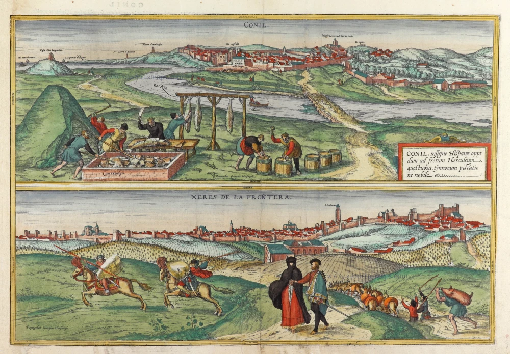
Conil de la Frontera and Jerez de la Frontera, by Georg Braun and Frans Hogenberg, after Georg Hoefnagel. 1576

CONIL DE LA FRONTERA
TRANSLATION OF CARTOUCHE TEXT: Conil, important Spanish town on the Strait of Hercules; well known due to its lucrative tuna fishing.
COMMENTARY BY BRAUN: "Conil, an attractive little town in Spain, well known due to its abundance of fish, especially tuna, which is caught there in large quantities. This town seems to have been destined by nature for fishing. [...] It has a baronial castle and next to it a very big house called La chauca de Ducque, where the fish are cut into pieces, salted and then exported in unbelievable quantities to Italy and the whole of the Mediterranean region with big ships."
The view of the small Atlantic port Conil de la Frontera is pushed into the background by the depiction of fishermen at work. On the bank of the river fishermen are bringing in their nets, and in the foreground fish are being dried and cut up. The mountain of salt on the left is used to cure the fish, which is then stored in wooden barrels. After Alfonso X succeeded in recapturing Conil from the Moors in 1265, the fishing monopoly was granted to the nobleman Alonso Pérez de Guzman in 1295. Tuna fishing continued to be the town's most important source of income for a long time. This southern Spanish town in the province of Cadiz in Andalusia lies on the popular Costa de la Luz, and is one of the much frequented pueblos blancos, or white villages.
JEREZ DE LA FRONTERA
COMMENTARY BY BRAUN: "Jerez is a famous and splendid city in Andalusia. [...] From here a strong and delectable wine is exported to Germany, Italy, England, Scotland, the Orient, even as far as India and other countries of the world. [...] This is where the very best and fastest horses in the whole of Spain, which are called Genets, can be found. The nobles know how to train them expertly."
The engraving shows the Andalusian city of Jerez de la Frontera in the background. The strongly fortified city walls indicate the role that Jerez played as a frontier town between the Moorish and Christian areas of sovereignty. After its recapture in 1264 by Alfonso X, King of the Romans, the church of San Salvador was built on the site of the old mosque, and it can be seen in the engraving to the right of the centre. Jerez attained world fame mainly through the production of sherry, the name being derived from the pronunciation of the town's earlier Arabic name, "Sherish". After the final defeat of the Moors in 1492, horse breeding flourished. Today the city of Jerez is still well known for its "vino Jerez" (sherry), and because of the Royal Andalusian School of Equestrian Art. (Taschen) !
Braun G. & Hogenberg F. and the Civitates Orbis Terrarum.
The Civitates Orbis Terrarum, also known as the 'Braun & Hogenberg', is a six-volume town atlas and the most excellent book of town views and plans ever published: 363 engravings, sometimes beautifully coloured. It was one of the best-selling works in the last quarter of the 16th century. Georg Braun, a skilled writer, wrote the text accompanying the plans and views on the verso. Many plates were engraved after the original drawings of a professional artist, Joris Hoefnagel (1542-1600). The first volume was published in Latin in 1572 and the sixth in 1617. Frans Hogenberg, a talented engraver, created the tables for volumes I through IV, and Simon van den Neuwel made those for volumes V and VI. Other contributors were cartographers Daniel Freese and Heinrich Rantzau, who provided valuable geographical information. Works by Jacob van Deventer, Sebastian Münster, and Johannes Stumpf were also used as references. Translations appeared in German and French, making the atlas accessible to a broader audience.
Since its original publication of volume 1 in 1572, the Civitates Orbis Terrarum has left an indelible mark on the history of cartography. Seven more editions followed the first volume in 1575, 1577, 1582, 1588, 1593, 1599, and 1612. Vol.2, initially released in 1575, saw subsequent editions in 1597 and 1612. The subsequent volumes, each a treasure trove of historical insights, graced the world in 1581, 1588, 1593, 1599, and 1606. The German translation of the first volume, a testament to its widespread appeal, debuted in 1574, followed by the French edition in 1575.
Several printers were involved: Theodor Graminaeus, Heinrich von Aich, Gottfried von Kempen, Johannis Sinniger, Bertram Buchholtz, and Peter von Brachel, all of whom worked in Cologne.
Georg Braun (1541-1622)
Georg Braun, the author of the text accompanying the plans and views in the Civitates Orbis Terrarum, was born in Cologne in 1541. After his studies in Cologne, he entered the Jesuit Order as a novice, indicating his commitment to learning and intellectual pursuits. In 1561, he obtained his bachelor's degree; in 1562, he received his Magister Artium, further demonstrating his academic achievements. Although he left the Jesuit Order, he continued his studies in theology, gaining a licentiate in theology. His theological background likely influenced the content and tone of the text in the Civitates Orbis Terrarum, adding a unique perspective to the work.
Frans Hogenberg (1535-1590)
Frans Hogenberg was a Flemish and German painter, engraver, and mapmaker. He was born in Mechelen as the son of Nicolaas Hogenberg.
By the end of the 1560s, Frans Hogenberg was employed upon Abraham Ortelius's Theatrum Orbis Terrarum, published in 1570; he is named an engraver of numerous maps. In 1568, he was banned from Antwerp by the Duke of Alva and travelled to London, where he stayed a few years before emigrating to Cologne. He immediately embarked on his two most important works, the Civitates, published in 1572 and the Geschichtsblätter, which appeared in several series from 1569 until about 1587.
Thanks to large-scale projects like the Geschichtsblätter and the Civitates, Hogenberg's social circumstances improved with each passing year. He died as a wealthy man in Cologne in 1590.
Conil [on sheet with] Xeres de la Frontera
Item Number: 4133 Authenticity Guarantee
Category: Antique maps > Europe > Spain and Portugal
Two antique bird’s-eye view plans of Conil de la Frontera and Jerez de la Frontera, by Georg Braun and Frans Hogenberg, after Georg Hoefnagel.
Title: Conil [on sheet with] Xeres de la Frontera
Date of the first edition: 1575.
Date of this map: 1576.
Copper engraving, printed on paper.
Size (not including margins): 315 x 460mm (12.4 x 18.11 inches).
Verso: German text.
Condition: Uncoloured, light browned at centre.
Condition Rating: A.
From: Beschreibung und Contrafactur von den vornembsten Stetten der Welt. Dass ander Buch. Köln, 1576. (Van der Krogt 4, 41:2.2)
CONIL DE LA FRONTERA
TRANSLATION OF CARTOUCHE TEXT: Conil, important Spanish town on the Strait of Hercules; well known due to its lucrative tuna fishing.
COMMENTARY BY BRAUN: "Conil, an attractive little town in Spain, well known due to its abundance of fish, especially tuna, which is caught there in large quantities. This town seems to have been destined by nature for fishing. [...] It has a baronial castle and next to it a very big house called La chauca de Ducque, where the fish are cut into pieces, salted and then exported in unbelievable quantities to Italy and the whole of the Mediterranean region with big ships."
The view of the small Atlantic port Conil de la Frontera is pushed into the background by the depiction of fishermen at work. On the bank of the river fishermen are bringing in their nets, and in the foreground fish are being dried and cut up. The mountain of salt on the left is used to cure the fish, which is then stored in wooden barrels. After Alfonso X succeeded in recapturing Conil from the Moors in 1265, the fishing monopoly was granted to the nobleman Alonso Pérez de Guzman in 1295. Tuna fishing continued to be the town's most important source of income for a long time. This southern Spanish town in the province of Cadiz in Andalusia lies on the popular Costa de la Luz, and is one of the much frequented pueblos blancos, or white villages.
JEREZ DE LA FRONTERA
COMMENTARY BY BRAUN: "Jerez is a famous and splendid city in Andalusia. [...] From here a strong and delectable wine is exported to Germany, Italy, England, Scotland, the Orient, even as far as India and other countries of the world. [...] This is where the very best and fastest horses in the whole of Spain, which are called Genets, can be found. The nobles know how to train them expertly."
The engraving shows the Andalusian city of Jerez de la Frontera in the background. The strongly fortified city walls indicate the role that Jerez played as a frontier town between the Moorish and Christian areas of sovereignty. After its recapture in 1264 by Alfonso X, King of the Romans, the church of San Salvador was built on the site of the old mosque, and it can be seen in the engraving to the right of the centre. Jerez attained world fame mainly through the production of sherry, the name being derived from the pronunciation of the town's earlier Arabic name, "Sherish". After the final defeat of the Moors in 1492, horse breeding flourished. Today the city of Jerez is still well known for its "vino Jerez" (sherry), and because of the Royal Andalusian School of Equestrian Art. (Taschen) !
Braun G. & Hogenberg F. and the Civitates Orbis Terrarum.
The Civitates Orbis Terrarum, also known as the 'Braun & Hogenberg', is a six-volume town atlas and the most excellent book of town views and plans ever published: 363 engravings, sometimes beautifully coloured. It was one of the best-selling works in the last quarter of the 16th century. Georg Braun, a skilled writer, wrote the text accompanying the plans and views on the verso. Many plates were engraved after the original drawings of a professional artist, Joris Hoefnagel (1542-1600). The first volume was published in Latin in 1572 and the sixth in 1617. Frans Hogenberg, a talented engraver, created the tables for volumes I through IV, and Simon van den Neuwel made those for volumes V and VI. Other contributors were cartographers Daniel Freese and Heinrich Rantzau, who provided valuable geographical information. Works by Jacob van Deventer, Sebastian Münster, and Johannes Stumpf were also used as references. Translations appeared in German and French, making the atlas accessible to a broader audience.
Since its original publication of volume 1 in 1572, the Civitates Orbis Terrarum has left an indelible mark on the history of cartography. Seven more editions followed the first volume in 1575, 1577, 1582, 1588, 1593, 1599, and 1612. Vol.2, initially released in 1575, saw subsequent editions in 1597 and 1612. The subsequent volumes, each a treasure trove of historical insights, graced the world in 1581, 1588, 1593, 1599, and 1606. The German translation of the first volume, a testament to its widespread appeal, debuted in 1574, followed by the French edition in 1575.
Several printers were involved: Theodor Graminaeus, Heinrich von Aich, Gottfried von Kempen, Johannis Sinniger, Bertram Buchholtz, and Peter von Brachel, all of whom worked in Cologne.
Georg Braun (1541-1622)
Georg Braun, the author of the text accompanying the plans and views in the Civitates Orbis Terrarum, was born in Cologne in 1541. After his studies in Cologne, he entered the Jesuit Order as a novice, indicating his commitment to learning and intellectual pursuits. In 1561, he obtained his bachelor's degree; in 1562, he received his Magister Artium, further demonstrating his academic achievements. Although he left the Jesuit Order, he continued his studies in theology, gaining a licentiate in theology. His theological background likely influenced the content and tone of the text in the Civitates Orbis Terrarum, adding a unique perspective to the work.
Frans Hogenberg (1535-1590)
Frans Hogenberg was a Flemish and German painter, engraver, and mapmaker. He was born in Mechelen as the son of Nicolaas Hogenberg.
By the end of the 1560s, Frans Hogenberg was employed upon Abraham Ortelius's Theatrum Orbis Terrarum, published in 1570; he is named an engraver of numerous maps. In 1568, he was banned from Antwerp by the Duke of Alva and travelled to London, where he stayed a few years before emigrating to Cologne. He immediately embarked on his two most important works, the Civitates, published in 1572 and the Geschichtsblätter, which appeared in several series from 1569 until about 1587.
Thanks to large-scale projects like the Geschichtsblätter and the Civitates, Hogenberg's social circumstances improved with each passing year. He died as a wealthy man in Cologne in 1590.
Related items
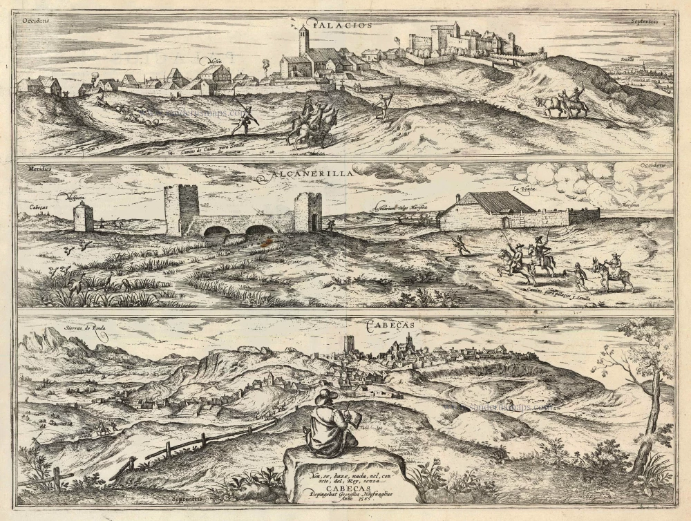
Palacios [on sheet with:] Alcanerilla [and] Cabecas. 1623
Palacios - Alcantarilla - Cabecas by Georg Braun & Frans Hogenberg.
[Item number: 103]
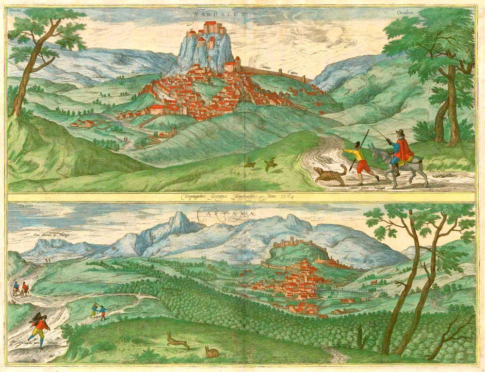
Hardales [on sheet with] Cartama. 1596
Ardales & Cartama by Georg Braun & Frans Hogenberg.
[Item number: 229]

Toletum [on sheet with] Vallisoletum ... Nobilis. Totius Hispania Oppidum 1572-1624
Toledo & Valladolid by Georg Braun & Frans Hogenberg.
[Item number: 2067]
Conil [on sheet with] Xeres de la Frontera 1576
Conil de la Frontera and Jerez de la Frontera, by Georg Braun and Frans Hogenberg, after Georg Hoefnagel.
[Item number: 4133]

Burgos celebris et antiqua Hispaniae civitas, ... [on sheet with] Sanct. Sebastianum vulgo Donosien ad Occanum ... 1582
Burgos - San Sebastian by Braun & Hogenberg
[Item number: 14159]

Granata. 1623
Granada by Georg Braun & Frans Hogenberg.
[Item number: 16665]

Marchena [on sheet with] Onchuna. 1588-97
Marchena and Osuna, by Georg Braun and Frans Hogenberg.
[Item number: 22247]

Loxa. 1623
Loja, by Georg Braun and Frans Hogenberg.
[Item number: 22365]
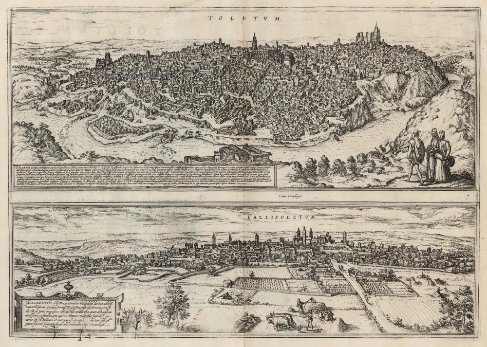
Toletum [on sheet with] Vallisoletum ... Nobilis. Totius Hispania Oppidum 1599
Toledo and Valladolid, by Georg Braun and Frans Hogenberg.
[Item number: 23899]
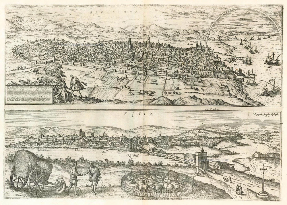
Barcelona, Barcino, que vulgo Barcelona Dicitur [on sheet with] Ecija 1599
Barcelona and Ecija, by Georg Braun and Frans Hogenberg.
[Item number: 23901]
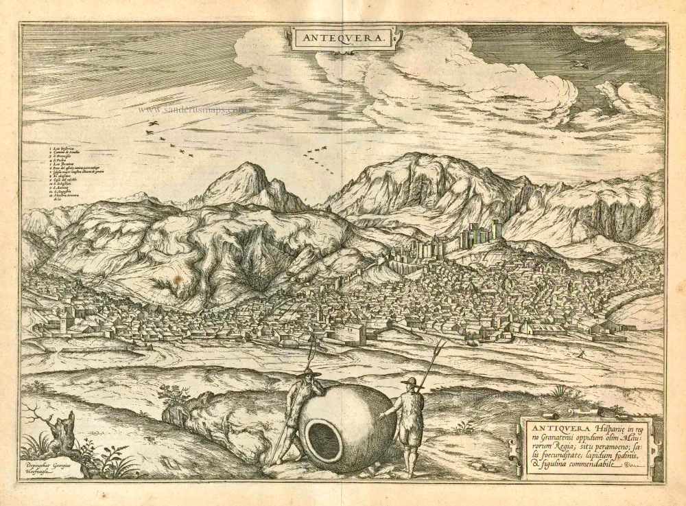
Antequera 1597
Antiquera, by Georg Braun and Frans Hogenberg.
[Item number: 23958]

Vegel [on sheet with] Velis Malaga 1597
Vejer de la Frontera and Vélez-Málaga, by Georg Braun and Frans Hogenberg.
[Item number: 23959]

Le Brixa [on sheet with] Settenil. 1599
Lebrija & Settenil de las Bodegas, by Georg Braun and Frans Hogenberg.
[Item number: 24018]

La Penna de los Enamorados - Archidona 1596
The mountain La Peña de los Enamorados and the village Archidona, by Georg Braun and Frans Hogenberg.
[Item number: 24140]

Hardales [on sheet with] Cartama 1596
Ardales and Cartama, by Georg Braun and Frans Hogenberg.
[Item number: 24142]

Bornnes [on sheet with] Zahara 1596
Bornes and Zahara, by Georg Braun and Frans Hogenberg.
[Item number: 24143]

Granada 1563. 1582
Granada, by Georg Braun and Frans Hogenberg.
[Item number: 25487]
Conil [on sheet with] Xeres de la Frontera. 1575
Conil de la Frontera - Jerez de la Frontera, by Braun & Hogenberg after Georg Hoefnagel.
[Item number: 31260]