
An outstanding example of late seventeenth-century Italian cartography
Africa by Coronelli V.M. 1691
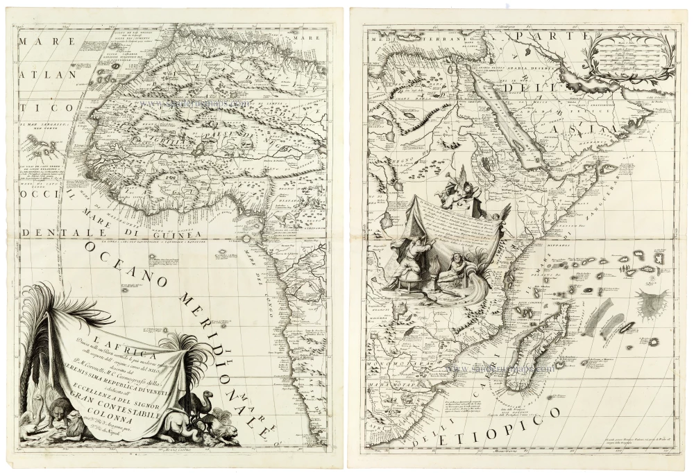
A magnificent and highly detailed two-sheet map of Africa by Vincenzo Maria Coronelli, one of the most celebrated Italian cartographers of the late seventeenth century. Published in Venice in 1691, this impressive map combines the latest geographical knowledge available to European cartographers with elaborate Baroque decoration.
The map depicts the African continent in two separate, unjoined sheets, extending from the Mediterranean coast in the north to the Cape of Good Hope in the south. Coronelli presents an exceptionally rich geographical image, incorporating numerous place names, rivers, mountain ranges, kingdoms, provinces, and indigenous territories. The coastlines are depicted with considerable detail, reflecting the accumulated knowledge of Portuguese, Dutch, and other European navigators, while the interior preserves a mixture of contemporary geographical information, travellers' accounts, and traditional cartographic conjecture.
Of particular interest is Coronelli's treatment of the Nile and its sources, a geographical question that continued to fascinate European scholars throughout the seventeenth century. As indicated in the title, the map incorporates recent accounts concerning the origin and course of the river. The Nile is shown flowing north through Nubia and Egypt, while its upper reaches reflect Europe's still imperfect understanding of northeastern Africa's interior. The depiction of the great lakes and river systems illustrates the transitional character of African cartography at the end of the seventeenth century, when traditional geographical concepts were gradually being reconsidered in the light of new reports.
The western sheet encompasses northwestern and western Africa, including the Barbary Coast, the Sahara, Guinea, and the Atlantic islands, together with part of west-central Africa. The eastern sheet covers northeastern, eastern, and southern Africa, including Egypt, Nubia, Abyssinia, the Horn of Africa, the East African coast, Madagascar, and the Cape of Good Hope. The surrounding seas are extensively labelled, and numerous explanatory notes provide additional geographical and historical information.
The map is distinguished by its magnificent decorative engraving. On the western sheet, an elaborate dedicatory cartouche takes the form of a large draped banner, surrounded by palm fronds and an assortment of African animals, including lions, an elephant, and a camel. The dedication is addressed to Colonna, Gran Contestabile, a prominent member of the Roman aristocracy. On the eastern sheet, a large allegorical composition features female figures, putti, and a flowing vessel that supports a richly ornamented explanatory panel. A further decorative cartouche, framed by graceful foliage, occupies the upper right corner.
Coronelli's characteristic engraving style is evident throughout, particularly in the finely delineated mountain ranges, carefully rendered coastlines, dense geographical nomenclature, and elegant lettering. The combination of geographical detail and theatrical Baroque ornament makes this one of the most impressive representations of Africa produced in late seventeenth-century Venice.
An outstanding example of late seventeenth-century Italian cartography, combining Coronelli's remarkable geographical scholarship with the decorative splendour of Venetian Baroque engraving.
Vincenzo Coronelli (1650-1718)
Vincenzo Coronelli was born in Venice on 16 August 1650 and primarily brought up in Ravenna. He returned to Venice in 1665 and joined the convent of the Minor Conventuals. Five years later, he was sent to Rome to study, and by 1673, he was already a doctor of theology.
Having achieved fame by constructing two globes for the Duke of Parma, he was invited to Paris for three years in 1681 and made two enormous examples for Louis XIV. On his return to Venice, he assiduously collected cartographic material and founded the Academy of the Argonauts. In 1685, he was appointed Cosmographer to the Republic of Venice and authorised to publish a large atlas. He became a geography lecturer at the University of Venice and brought out an Atlante Veneto the following year.
In 1696, he visited Germany, Holland and southern England. During intervals in compiling his vast encyclopaedia, he continued with cartographic projects up to 1709. He died in his native Venice on 9 December 1718.
Coronelli became famous for his globes. In addition, he was a renowned encyclopaedist, mapmaker and geographer. Most of his maps and other material are gathered in his Atlante Veneto (13 vols, 1690-1705). The first volume, subtitled Descrizione generale istorica geografica, was his masterpiece, planned as an extension of Blaeu’s atlas.
Other volumes of the atlas which contain maps are Isolario, two parts (1696-8), with detailed maps and plans, mostly of islands; Corso geografico, two parts based on the edition 1694-7; Libro de’ globi (1697); and Lo Specchio del Mare, a reprint of Levanto's Lo Specchio del Mare Mediterraneo of 1664.
The other vital aspects of his mapping are those arising from the Venetian conquest and his travels. His most extensive military compilation was the Teatro della Guerra, in more than 30 volumes.
L'Africa Divisa nelle sue Parti Secondo le Piu Moderne Relationi colle scoperte dell' origine, e corso del Nilo,
Item Number: 33307 new Authenticity Guarantee
Category: Antique maps > Africa
Africa by Coronelli V.M.
Title: L'Africa Divisa nelle sue Parti Secondo le Piu Moderne Relationi colle scoperte dell' origine, e corso del Nilo,
descritta dal P.M. Coronelli M.C. Cosmografo della Serenissima Repubblica di Venetia, ...
Date of the first edition: 1691.
Date of this map: 1691.
Copper engravings, printed on paper, two double sheets, unjoined.
Image size each: 605 x 455mm (23¾ x 18 inches).
Sheet size each: 650 x 475mm (25½ x 18¾ inches).
Verso: Blank.
Condition: Excellent.
Condition Rating: A+.
From: Atlante Veneto, nel quale si contiene la descrittione... degl' Imperii, Regni, Provincie, e Stati dell' Universo. Venice: Girolamo Albrizzi, 1691. Shirley (Brit.Lib.), T.CORO-7a
A magnificent and highly detailed two-sheet map of Africa by Vincenzo Maria Coronelli, one of the most celebrated Italian cartographers of the late seventeenth century. Published in Venice in 1691, this impressive map combines the latest geographical knowledge available to European cartographers with elaborate Baroque decoration.
The map depicts the African continent in two separate, unjoined sheets, extending from the Mediterranean coast in the north to the Cape of Good Hope in the south. Coronelli presents an exceptionally rich geographical image, incorporating numerous place names, rivers, mountain ranges, kingdoms, provinces, and indigenous territories. The coastlines are depicted with considerable detail, reflecting the accumulated knowledge of Portuguese, Dutch, and other European navigators, while the interior preserves a mixture of contemporary geographical information, travellers' accounts, and traditional cartographic conjecture.
Of particular interest is Coronelli's treatment of the Nile and its sources, a geographical question that continued to fascinate European scholars throughout the seventeenth century. As indicated in the title, the map incorporates recent accounts concerning the origin and course of the river. The Nile is shown flowing north through Nubia and Egypt, while its upper reaches reflect Europe's still imperfect understanding of northeastern Africa's interior. The depiction of the great lakes and river systems illustrates the transitional character of African cartography at the end of the seventeenth century, when traditional geographical concepts were gradually being reconsidered in the light of new reports.
The western sheet encompasses northwestern and western Africa, including the Barbary Coast, the Sahara, Guinea, and the Atlantic islands, together with part of west-central Africa. The eastern sheet covers northeastern, eastern, and southern Africa, including Egypt, Nubia, Abyssinia, the Horn of Africa, the East African coast, Madagascar, and the Cape of Good Hope. The surrounding seas are extensively labelled, and numerous explanatory notes provide additional geographical and historical information.
The map is distinguished by its magnificent decorative engraving. On the western sheet, an elaborate dedicatory cartouche takes the form of a large draped banner, surrounded by palm fronds and an assortment of African animals, including lions, an elephant, and a camel. The dedication is addressed to Colonna, Gran Contestabile, a prominent member of the Roman aristocracy. On the eastern sheet, a large allegorical composition features female figures, putti, and a flowing vessel that supports a richly ornamented explanatory panel. A further decorative cartouche, framed by graceful foliage, occupies the upper right corner.
Coronelli's characteristic engraving style is evident throughout, particularly in the finely delineated mountain ranges, carefully rendered coastlines, dense geographical nomenclature, and elegant lettering. The combination of geographical detail and theatrical Baroque ornament makes this one of the most impressive representations of Africa produced in late seventeenth-century Venice.
An outstanding example of late seventeenth-century Italian cartography, combining Coronelli's remarkable geographical scholarship with the decorative splendour of Venetian Baroque engraving.
Vincenzo Coronelli (1650-1718)
Vincenzo Coronelli was born in Venice on 16 August 1650 and primarily brought up in Ravenna. He returned to Venice in 1665 and joined the convent of the Minor Conventuals. Five years later, he was sent to Rome to study, and by 1673, he was already a doctor of theology.
Having achieved fame by constructing two globes for the Duke of Parma, he was invited to Paris for three years in 1681 and made two enormous examples for Louis XIV. On his return to Venice, he assiduously collected cartographic material and founded the Academy of the Argonauts. In 1685, he was appointed Cosmographer to the Republic of Venice and authorised to publish a large atlas. He became a geography lecturer at the University of Venice and brought out an Atlante Veneto the following year.
In 1696, he visited Germany, Holland and southern England. During intervals in compiling his vast encyclopaedia, he continued with cartographic projects up to 1709. He died in his native Venice on 9 December 1718.
Coronelli became famous for his globes. In addition, he was a renowned encyclopaedist, mapmaker and geographer. Most of his maps and other material are gathered in his Atlante Veneto (13 vols, 1690-1705). The first volume, subtitled Descrizione generale istorica geografica, was his masterpiece, planned as an extension of Blaeu’s atlas.
Other volumes of the atlas which contain maps are Isolario, two parts (1696-8), with detailed maps and plans, mostly of islands; Corso geografico, two parts based on the edition 1694-7; Libro de’ globi (1697); and Lo Specchio del Mare, a reprint of Levanto's Lo Specchio del Mare Mediterraneo of 1664.
The other vital aspects of his mapping are those arising from the Venetian conquest and his travels. His most extensive military compilation was the Teatro della Guerra, in more than 30 volumes.
Related items

Africa Ex magna orbis terre 1633
Africa, by G. Mercator.
[Item number: 1452]

Africae Antiquae, et quarundam Europae, Asiaeque Adiacentium Regionum, 1684
Africa, by Janssonius à Waesberghe.
[Item number: 10916]

Africa Tertia Pars Terrae. 1581
Africa, by H. Bünting.
[Item number: 26228]

Scarce
Africae Tabula Nova. 1575
Africa, by François de Belleforest.
[Item number: 27380]

Affricae Tabula Nova. 1598
Africa, by Sebastian Münster.
[Item number: 27416]

Big and beautiful map.
L'Afrique Selon les Nouvelles Observations de Messrs. de l'Academie des Sciences, etc. Before 1713
Africa, by François Halma.
[Item number: 27853]
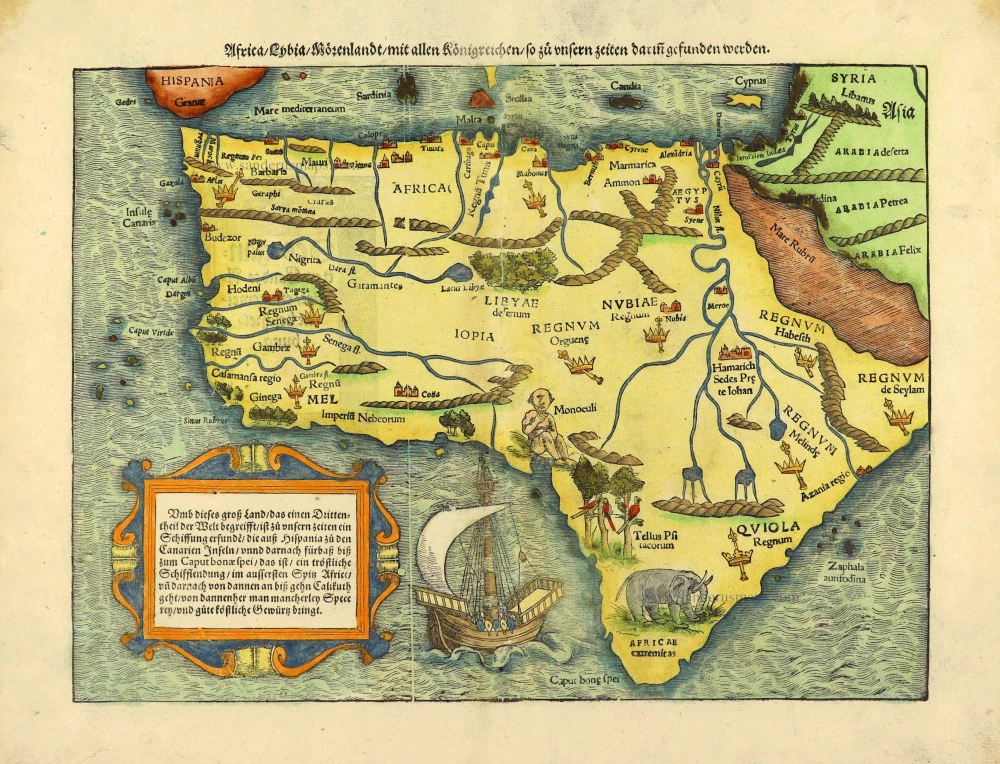
Africa / Lybia / Morenland / mit allen Künigreichen / so zu unsern zeiten darin gefunden werden. 1572
Africa by Sebastian Münster.
[Item number: 28142]

Rare
Africa. 1725-50.
Allegorical title page of Africa by Joan Blaeu, published by Reinier & Josua Ottens.
[Item number: 28506]

Africae Accurata Tabula. c. 1660
Africa by Nicolaes Visscher I.
[Item number: 28551]

Africa Ex magna orbis terre. 1623
Africa by Gerard Mercator.
[Item number: 28678]

Africae Antiquae, et quarundam Europae, Asiaeque Adiacentium Regionum, 1684
Africa, by Janssonius à Waesberghe.
[Item number: 29053]

Totius Africae Accuratissima Tabula, c. 1697-1704
Africa, by Frederick De Wit.
[Item number: 29289]

SCARCE !
Kuching. 1685/90
View of Tianjin (Tientsin - China), by Carel Allard.
[Item number: 30585]

Africa 1621
Africa by Giovanni Magini.
[Item number: 30775]

Important map
Africae Tabula Nova. 1575
Africa by Abraham Ortelius
[Item number: 30948]

L'Afrique divisée suivant l'estendue de ses principales parties ou sont distingués les uns des autres, Les Empires, Monarchies, Royaumes, Estats et Peuples qui partagent aujourd'huy l'Afrique sur les Relations les plus Nouvelles. 1692
Africa, by N. Sanson, so-called published by Hubert Jaillot. (Pirated edition by Pierre Mortier).
[Item number: 31141]

Beautiful
Tabula Quarta Africae 1513
Ptolemy map of Africa by Martin Waldseemüller
[Item number: 31187]

Africae nova descriptio. 1640
Africa by Willem Blaeu.
[Item number: 31334]

Totius Africae Accuratissima Tabula Authore I. Danckerts Amstelodami 1683-1690
Africa by Justus Danckerts.
[Item number: 31787]

Africa. 1618
Africa by Petrus Bertius, published by Jodocus Hondius II.
[Item number: 32060]

Totius Africae Nova Repraesentatio qua Practer Diversos in ea Status et Regiones, etiam Origo Nili 1712
Africa by Homann J.B.
[Item number: 32097]

Novissima et Perfectissima Africae 1696-1713
Africa by Danckerts J.
[Item number: 32459]
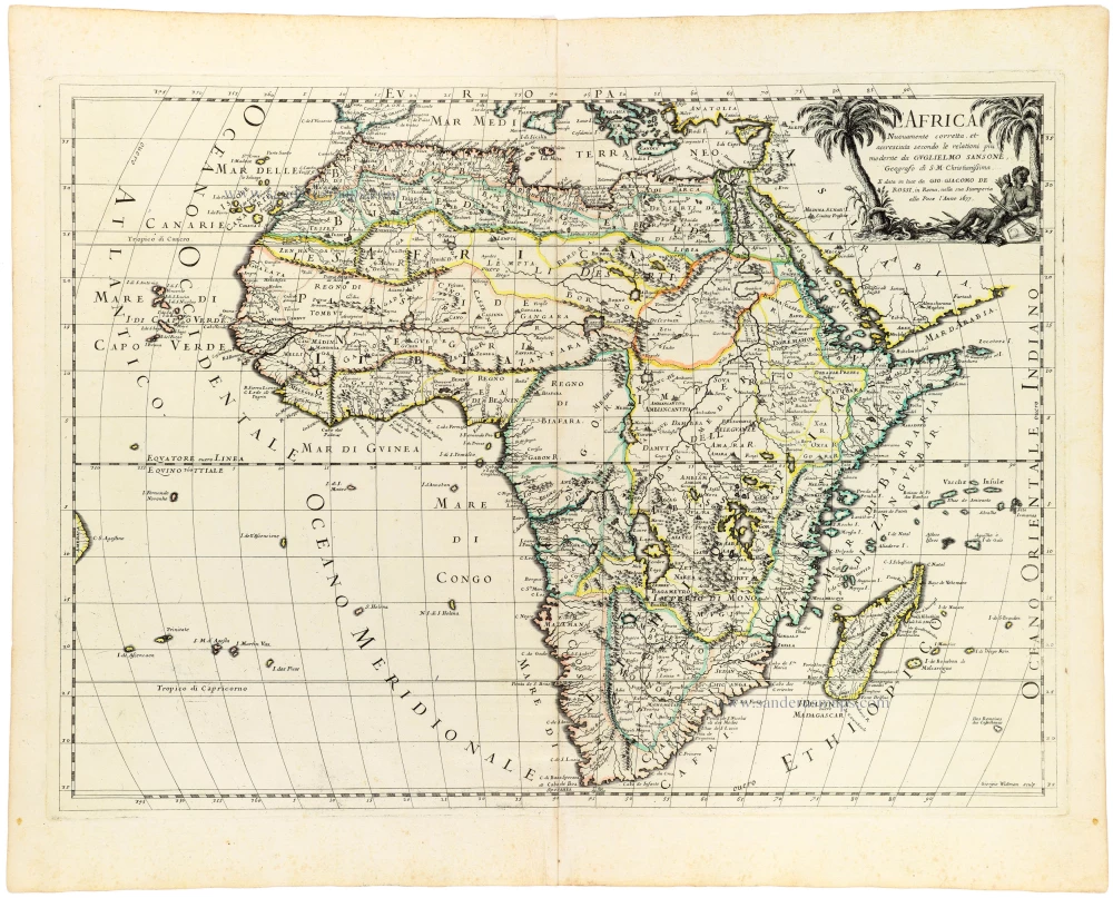
L' Africa. 1677
Africa by Giovanni De Rossi, after Nicolas Sanson.
[Item number: 32888]

L'Afrique divisée en ses principaux Etats. 1762
Africa by Jean Denis Janvier, published by Jean Lattré.
[Item number: 33071]

Afrique. 1659
Africa by Nicolas Sanson.
[Item number: 33215]
new