
World by Zürner A.F., double hemisphere. c. 1700
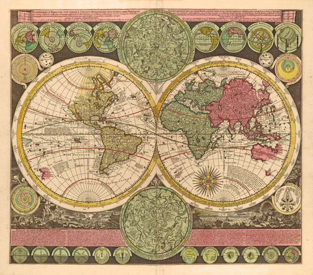
This striking map shows explorers' routes, including Magellan, Dampier, Tasman, Gaetani and Chaumont. Nova Britannia, an island adjacent to New Guinea, is shown with an inscription saying Dampier discovered it in 1700. Encircling the hemispheres are markings of the winds and climates. According to different projections, set around the border are no less than twenty-six smaller astronomical diagrams and hemispheres of the world. In addition, there are two larger celestial hemispheres and, at the bottom, a panorama illustrating storms, earthquakes, tides, vortices etc. Below, there is a textual commentary on the natural phenomena depicted.
Adam Friedrich Zürner (1679-1742)
A.F. Zürner made his first maps during his studies in Leipzig. In 1713, Elector August dem Starken gave him the order to bring all offices of the Electorate of Saxony in the same way as the two maps of the offices of Großenhain and Dresden. Zürner was supposed to complete the electorate survey, which was begun in 1586 by Matthias Oeder under Elector Christian I.
In 1716 he was awarded the title of "Electoral Saxon and Royal Polish Geographer". In the same year, he was appointed a member of the Prussian Academy of Sciences. Finally, in the late autumn of 1718, he presented his "New Chursächsische Post-Charte".
The geographer Johann Gottfried Gregorii alias Melissantes and the copper engraver Johann Christoph Weigel from Nuremberg used the good map material and Zürner's signature system as early as 1723 to create the continuous Atlas Portatilis Germanicus.
In addition to his surveying work, Zürner wrote several travel guides in the last years of his life. He worked, among others, with the Homann Heirs firm and the Schenk family. He died on December 18, 1742, in Dresden.
Today he is considered a well-known German cartographer. His best-known works were the Neue Chursächsische Post-Charte (16 sheets) and the Atlas Augusteus der Chursächsische Lande (Atlas Augusteus Saxonicus: 40 general and 40 special maps).
Planisphaerium Terrestre cum utroque Coelesti Hemisphaerio, sive Diversa Orbis Terraquei,
Item Number: 28229 Authenticity Guarantee
Category: Antique maps > World
Old, antique world map - double hemisphere, by Zürner A.F..
Title: Planisphaerium Terrestre cum utroque Coelesti Hemisphaerio, sive Diversa Orbis Terraquei,
pro variatis divisionis, conspectus variarumque positionum et observationum circumstantiis, multis in locis correcta, ...
Opera et studio A.F. Zürneri. ...
Ex Officina Petri Schenkii in Platea vulgo
With numerous polar & celestial spheres, astronomical diagrams, etc. Insular California.
Date of the first edition: c. 1700.
Date of this map: c. 1700.
Copper engraving, printed on paper.
Size (not including margins): 500 x 575mm (19.69 x 22.64 inches).
Verso: Blank.
Condition: Original hand coloured, excellent.
Condition Rating: A+.
References: Shirley (World) #639
From: Schenk, Atlas Contractus sive Mapparum Geographicarum Sansoniarum auctarum et Correctarum. Amsterdam, c. 1700. (Koeman, Sche 2)
This striking map shows explorers' routes, including Magellan, Dampier, Tasman, Gaetani and Chaumont. Nova Britannia, an island adjacent to New Guinea, is shown with an inscription saying Dampier discovered it in 1700. Encircling the hemispheres are markings of the winds and climates. According to different projections, set around the border are no less than twenty-six smaller astronomical diagrams and hemispheres of the world. In addition, there are two larger celestial hemispheres and, at the bottom, a panorama illustrating storms, earthquakes, tides, vortices etc. Below, there is a textual commentary on the natural phenomena depicted.
Adam Friedrich Zürner (1679-1742)
A.F. Zürner made his first maps during his studies in Leipzig. In 1713, Elector August dem Starken gave him the order to bring all offices of the Electorate of Saxony in the same way as the two maps of the offices of Großenhain and Dresden. Zürner was supposed to complete the electorate survey, which was begun in 1586 by Matthias Oeder under Elector Christian I.
In 1716 he was awarded the title of "Electoral Saxon and Royal Polish Geographer". In the same year, he was appointed a member of the Prussian Academy of Sciences. Finally, in the late autumn of 1718, he presented his "New Chursächsische Post-Charte".
The geographer Johann Gottfried Gregorii alias Melissantes and the copper engraver Johann Christoph Weigel from Nuremberg used the good map material and Zürner's signature system as early as 1723 to create the continuous Atlas Portatilis Germanicus.
In addition to his surveying work, Zürner wrote several travel guides in the last years of his life. He worked, among others, with the Homann Heirs firm and the Schenk family. He died on December 18, 1742, in Dresden.
Today he is considered a well-known German cartographer. His best-known works were the Neue Chursächsische Post-Charte (16 sheets) and the Atlas Augusteus der Chursächsische Lande (Atlas Augusteus Saxonicus: 40 general and 40 special maps).
Related items

Mappemonde en deux Hémisphères. c. 1797
World map, double hemisphere by Pierre Grégoire Chanlaire.
[Item number: 28209]

Mapmonde ou description generale du Globe Terrestre. 1713
World map by Zacharias Châtelain.
[Item number: 29555]
Mappe-Monde, ou Carte Generale du Monde, 1652
Double hemisphere world map by Nicolas Sanson.
[Item number: 29612]

Mercator projection
Discorso Intorno alla Carta da Navigare. 1590
World by Thomaso Porcacchi.
[Item number: 29786]

Mappe-Monde 1766-1780
World map by Louis Brion de la Tour, published by L.C Desnos.
[Item number: 30100]

'One of the supreme examples of map maker's art' (Shirley)
Nova Totius Terrarum Orbis Geographica ac Hydrographica. 1643
World by Willem Blaeu, in Mercator projection.
[Item number: 30271]
Rare 1525 edition in nice old colour.
[No title] 1525
Ptolemaic world by Lorenz Fries after Martin Waldseemüller.
[Item number: 30649]

Mappe-Monde Geo-Hydrographique, ou Description Generale du Globe Terrestre et Aquatique en Deux Plans-Hemispheres ... 1692
World map by Nicolas Sanson, so-called published by Hubert Jaillot. (Pirated edition by Pierre Mortier).
[Item number: 31136]

Typus Orbis Terrarum. 1618
World by Petrus Bertius, published by Jodocus Hondius II.
[Item number: 31520]

Gottfried's first edition 1631
[no title] 1631
Willem C. Schouten, world map published by Gottfried.
[Item number: 31560]

Rare first edition
[no title] 1618
World map in two hemispheres by Willem W. Schouten.
[Item number: 31601]

An Essay of a New and Compact Map, containing the known parts of the Terrestrial Globe. 1750
World map by Jacques-Nicolas Bellin, published by A.F. Prévost.
[Item number: 31883]

Beautiful example of this important world map
Typus Orbis Terrarum. 1584
World by Abraham Ortelius.
[Item number: 32090]

Planiglobii Terrestris cum Utroq Hemisphaerio Caelesti Generalis Repraesentatio. c. 1720
World by Homann J.B., double hemisphere.
[Item number: 32099]

Early Mercator projection
Universi Orbis Descriptio Ad Usum Navigantium. 1597
World by Giovanni Magini.
[Item number: 32281]

Carta Marina Nuova Tavola. 1574
World chart by Girolamo Ruscelli.
[Item number: 32432]

Orbis Descriptio. 1574
World in two hemisperes, by Girolamo Ruscelli.
[Item number: 32433]

Rare first state of Danckerts beautiful world map
Nova Totius Terrarum Orbis Tabula.. c. 1680
Double hemisphere world map by Justus Danckerts
[Item number: 32456]

The most mystical world map of all time.
[No title] 1560-1600
Daniel's Dream Map. The Wittenberg world map by Hanss Luft.
[Item number: 32507]
'One of the supreme examples of map maker's art' (Shirley)
Nova Totius Terrarum Orbis Geographica ac Hydrographica. 1635
World by Willem Blaeu, in Mercator projection.
[Item number: 32683]

Mappa Mondo O Vero Carta Generale Del Globo Terestre 1677
World in two hemisphers by Giovanni De Rossi, after Nicolas Sanson.
[Item number: 32885]

Typus Orbis Terrarum. 1618
World by Petrus Bertius.
[Item number: 33183]
new