
Europe, by V.M. Coronelli. 1691
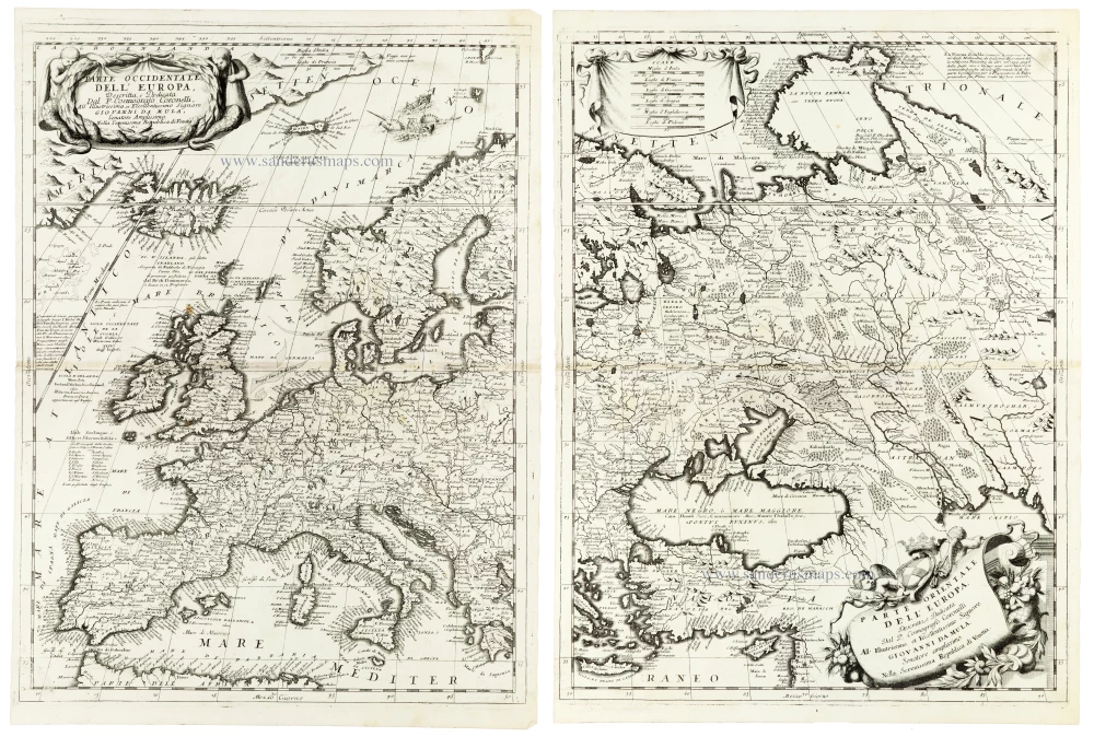
A magnificent and exceptionally detailed two-sheet map of Europe by Vincenzo Maria Coronelli, one of the most distinguished cartographers of the Italian Baroque period. Published in his celebrated Atlante Veneto in 1691, this impressive map presents an extraordinarily comprehensive geographical picture of Europe at the close of the seventeenth century.
The western sheet, Parte Occidentale dell'Europa, encompasses the British Isles, France, the Iberian Peninsula, the Low Countries, Germany, Italy, and Scandinavia, extending northwards to Iceland and the Arctic regions and southwards to the Mediterranean and the northern coast of Africa. The Atlantic Ocean occupies the northwestern portion of the composition, with numerous geographical annotations and references to maritime exploration.
The eastern sheet, Parte Orientale dell'Europa, continues eastwards across Scandinavia, the Baltic countries, Poland, Russia, and southeastern Europe, extending to the Black Sea, the Caspian Sea, the Caucasus, and parts of the Ottoman Empire. The vast territories of European Russia are represented with an impressive abundance of rivers, lakes, settlements, and regional names, illustrating both the geographical knowledge and the remaining uncertainties of the period.
The map is particularly interesting for its representation of the political geography of late seventeenth-century Europe. The complicated territorial divisions of the Holy Roman Empire, the extensive possessions of the Habsburg monarchy, the Polish-Lithuanian Commonwealth, and the Ottoman Empire are all reflected in the geographical nomenclature. The eastern sheet is especially significant as a cartographic record of southeastern Europe during a period of major political and military changes following the Ottoman defeat at Vienna in 1683 and the subsequent expansion of Habsburg influence.
Both sheets are distinguished by their exceptionally dense and meticulous engraving. Thousands of towns, villages, rivers, mountain ranges, lakes, and geographical names are recorded, demonstrating Coronelli's ambition to produce maps of exceptional geographical completeness. The coastlines, particularly those of Scandinavia, the Mediterranean, and the Black Sea, are rendered in considerable detail.
The decorative elements are equally impressive. The western sheet features a magnificent Baroque title cartouche in the upper left corner, with an elaborate draped inscription panel supported by two muscular male figures. On the eastern sheet, an equally elaborate cartouche occupies the lower right corner, embellished with allegorical figures, floral ornamentation, and flowing draperies. The cartouches contain Coronelli's dedication to Giovanni da Mula, a distinguished senator of the Venetian Republic.
The combination of monumental scale, extraordinarily rich geographical content, and elaborate Baroque ornamentation makes this map one of the most attractive representations of Europe produced in late seventeenth-century Venice.
Vincenzo Coronelli (1650-1718)
Vincenzo Coronelli was born in Venice on 16 August 1650 and primarily brought up in Ravenna. He returned to Venice in 1665 and joined the convent of the Minor Conventuals. Five years later, he was sent to Rome to study, and by 1673, he was already a doctor of theology.
Having achieved fame by constructing two globes for the Duke of Parma, he was invited to Paris for three years in 1681 and made two enormous examples for Louis XIV. On his return to Venice, he assiduously collected cartographic material and founded the Academy of the Argonauts. In 1685, he was appointed Cosmographer to the Republic of Venice and authorised to publish a large atlas. He became a geography lecturer at the University of Venice and brought out an Atlante Veneto the following year.
In 1696, he visited Germany, Holland and southern England. During intervals in compiling his vast encyclopaedia, he continued with cartographic projects up to 1709. He died in his native Venice on 9 December 1718.
Coronelli became famous for his globes. In addition, he was a renowned encyclopaedist, mapmaker and geographer. Most of his maps and other material are gathered in his Atlante Veneto (13 vols, 1690-1705). The first volume, subtitled Descrizione generale istorica geografica, was his masterpiece, planned as an extension of Blaeu’s atlas.
Other volumes of the atlas which contain maps are Isolario, two parts (1696-8), with detailed maps and plans, mostly of islands; Corso geografico, two parts based on the edition 1694-7; Libro de’ globi (1697); and Lo Specchio del Mare, a reprint of Levanto's Lo Specchio del Mare Mediterraneo of 1664.
The other vital aspects of his mapping are those arising from the Venetian conquest and his travels. His most extensive military compilation was the Teatro della Guerra, in more than 30 volumes.
Parte Occidentale dell'Europa [in set with] Parte Orientale dell'Europa
Item Number: 33305 new Authenticity Guarantee
Category: Antique maps > Europe > Europe Continent
Europe, by V.M. Coronelli.
Title: Parte Occidentale dell'Europa [in set with] Parte Orientale dell'Europa
Descritta, e Dedicata Dal P. Cosmografo Coronelli All' Illustrissimo, et Eccellentissimo Signore Giovanni da Mula, Senatore amplissimo Nella Serenissima Republica di Venetia, etc.
Date of the first edition: 1691.
Date of this map: 1691.
Copper engravings, printed on paper, two double sheets, unjoined.
Image size each: 610 x 450mm (24 x 17¾ inches).
Sheet size each: 645 x 475mm (25½ x 18¾ inches).
Verso: Blank.
Condition: Excellent.
Condition Rating: A+.
From: Atlante Veneto, nel quale si contiene la descrittione... degl' Imperii, Regni, Provincie, e Stati dell' Universo. Venice: Girolamo Albrizzi, 1691. Shirley (Brit.Lib.), T.CORO-7a
A magnificent and exceptionally detailed two-sheet map of Europe by Vincenzo Maria Coronelli, one of the most distinguished cartographers of the Italian Baroque period. Published in his celebrated Atlante Veneto in 1691, this impressive map presents an extraordinarily comprehensive geographical picture of Europe at the close of the seventeenth century.
The western sheet, Parte Occidentale dell'Europa, encompasses the British Isles, France, the Iberian Peninsula, the Low Countries, Germany, Italy, and Scandinavia, extending northwards to Iceland and the Arctic regions and southwards to the Mediterranean and the northern coast of Africa. The Atlantic Ocean occupies the northwestern portion of the composition, with numerous geographical annotations and references to maritime exploration.
The eastern sheet, Parte Orientale dell'Europa, continues eastwards across Scandinavia, the Baltic countries, Poland, Russia, and southeastern Europe, extending to the Black Sea, the Caspian Sea, the Caucasus, and parts of the Ottoman Empire. The vast territories of European Russia are represented with an impressive abundance of rivers, lakes, settlements, and regional names, illustrating both the geographical knowledge and the remaining uncertainties of the period.
The map is particularly interesting for its representation of the political geography of late seventeenth-century Europe. The complicated territorial divisions of the Holy Roman Empire, the extensive possessions of the Habsburg monarchy, the Polish-Lithuanian Commonwealth, and the Ottoman Empire are all reflected in the geographical nomenclature. The eastern sheet is especially significant as a cartographic record of southeastern Europe during a period of major political and military changes following the Ottoman defeat at Vienna in 1683 and the subsequent expansion of Habsburg influence.
Both sheets are distinguished by their exceptionally dense and meticulous engraving. Thousands of towns, villages, rivers, mountain ranges, lakes, and geographical names are recorded, demonstrating Coronelli's ambition to produce maps of exceptional geographical completeness. The coastlines, particularly those of Scandinavia, the Mediterranean, and the Black Sea, are rendered in considerable detail.
The decorative elements are equally impressive. The western sheet features a magnificent Baroque title cartouche in the upper left corner, with an elaborate draped inscription panel supported by two muscular male figures. On the eastern sheet, an equally elaborate cartouche occupies the lower right corner, embellished with allegorical figures, floral ornamentation, and flowing draperies. The cartouches contain Coronelli's dedication to Giovanni da Mula, a distinguished senator of the Venetian Republic.
The combination of monumental scale, extraordinarily rich geographical content, and elaborate Baroque ornamentation makes this map one of the most attractive representations of Europe produced in late seventeenth-century Venice.
Vincenzo Coronelli (1650-1718)
Vincenzo Coronelli was born in Venice on 16 August 1650 and primarily brought up in Ravenna. He returned to Venice in 1665 and joined the convent of the Minor Conventuals. Five years later, he was sent to Rome to study, and by 1673, he was already a doctor of theology.
Having achieved fame by constructing two globes for the Duke of Parma, he was invited to Paris for three years in 1681 and made two enormous examples for Louis XIV. On his return to Venice, he assiduously collected cartographic material and founded the Academy of the Argonauts. In 1685, he was appointed Cosmographer to the Republic of Venice and authorised to publish a large atlas. He became a geography lecturer at the University of Venice and brought out an Atlante Veneto the following year.
In 1696, he visited Germany, Holland and southern England. During intervals in compiling his vast encyclopaedia, he continued with cartographic projects up to 1709. He died in his native Venice on 9 December 1718.
Coronelli became famous for his globes. In addition, he was a renowned encyclopaedist, mapmaker and geographer. Most of his maps and other material are gathered in his Atlante Veneto (13 vols, 1690-1705). The first volume, subtitled Descrizione generale istorica geografica, was his masterpiece, planned as an extension of Blaeu’s atlas.
Other volumes of the atlas which contain maps are Isolario, two parts (1696-8), with detailed maps and plans, mostly of islands; Corso geografico, two parts based on the edition 1694-7; Libro de’ globi (1697); and Lo Specchio del Mare, a reprint of Levanto's Lo Specchio del Mare Mediterraneo of 1664.
The other vital aspects of his mapping are those arising from the Venetian conquest and his travels. His most extensive military compilation was the Teatro della Guerra, in more than 30 volumes.
Related items

Canada ou Nouvelle France. 1685
North America (Northeast), by A.M. Mallet.
[Item number: 26601]

Amerique Septentrionale. 1685
North America, by A.M. Mallet.
[Item number: 26643]

Karte von Nord-America, zur Geschichte von Neu-Frankreich. 1747-74
North America, by Jacques Nicolas Bellin.
[Item number: 26799]
Carte Générale du Canada, de la Louisiane, de la Floride, de la Caroline, de la Virginie, de la Nouvelle Angleterre etc. 1776-79
North America (East), by Paolo Santini.
[Item number: 26980]

Earliest obtainable map of North America
Mondo Nuovo - Descrittione del l'Isola et Terra di Sancta Croce, overo Mondo Nuovo. 1576
Tomaso Porcacchi., North America
[Item number: 27651]

Early 'Texas' map
Nueva Hispania Tabula Nova. 1574
North America, by Girolamo Ruscelli.
[Item number: 27755]

Amerique Septentrionale. 1748
North America by Robert de Vaugondy.
[Item number: 28157]
Amerique Septentrionale, Divisee en ses Principales Parties. 1694
North America, by Nicolas Sanson, published by Pierre Mortier after A.H. Jaillot.
[Item number: 29125]

Carte de la Nouvelle France, ou se Voit le Cours des Grandes Rivieres de S. Laurens & de Mississipi Aujourd'hui S. Louis, Aux environs des quelles se trouvent les Etats, Païs, Nations, Peuples &c. de la Floride, de la Louisiane, de la Virginie, de la Marie-Lande, de la Pensilvanie, du Nouveau Jersay, de la Nouvelle Yorck, de la Nouv. Angleterre, de l'Acadie, du Canada, des Esquimaux, des Hurons, des Iroquois, des Ilinois &c. Et de la Grande Ile de Terre Neuve:. 1719
Eastern North America (U.S.), by Zacharias Châtelain.
[Item number: 29365]

Nouvelle carte de l'Amérique Septentrionale dressée sur les plus nouvelles observations de Messieurs de l'Académie des Sciences et des meilleurs Géographes avec des tables très Instructives et Curieuses de la Division de tous les Etats et les différents souverains qui en sont possesseur. 1713
North America, by Zacharias Châtelain.
[Item number: 29445]

L'Amerique Septentrionale. 1708
North America by G. de L'Isle, published by Pierre Mortier.
[Item number: 29510]

Big and spectacular map, heightened in gold.
Amerique Septentrionale, divisée en ses principales parties, ou sont distingués les uns des autres Les Estats suivant qu'ils appartiennet Presentemet aux Francois, Castillans, Anglois, Suedois, Danois, Hollandois. 1692
North America by N. Sanson, so-called published by Hubert Jaillot. (Pirated edition by Pierre Mortier).
[Item number: 29895]

California as an island.
L'Amerique Septentrionale qui fait partie des Indes Occidentales. 1719
North America by Chiquet Jacques.
[Item number: 30085]

California as an island.
Americque Septentrionale. 1715
North America by Nicolas Sanson, published by Nicolas Chemereau.
[Item number: 30086]

From 'Diderot & d'Alembert'
Carte de la Californie Suivant I. La Carte manuscrite de l'Amérique de Mathieu Néron Pecci olen dresses à Florence en 1604. II. Sanson 1656. III. De l'Isle Amérique Sept. 1700. IV. le Pere Kino Jesuite en 1705. V. la Société des Jésuites en 1767. 1777
California by Robert de Vaugondy.
[Item number: 30091]

Carte de la Partie de l'Amérique Septentrionale, comprenant les Possessions Espagnoles. 1788
North America by Louis Brion de la Tour.
[Item number: 30144]

Carte d'Assemblage de l'Amérique Septen-le 1827
North America by Philippe Vandermaelen.
[Item number: 31099]

Amerique Septentrionale, Divisee en ses Principales Parties, ou sont Distingues les Uns des Autres les Estats Suivant qu'ils Appartiennent Presentemet aux Francois, Castillans, Anglois, Suedois, Danois, Hollandois. 1692
North America by N. Sanson, so-called published by Hubert Jaillot. (Pirated edition by Pierre Mortier).
[Item number: 31142]

L' America Settentrionale. 1677
North America by Giovanni De Rossi, after Nicolas Sanson.
[Item number: 32889]
Carte Contient Une Description des Isles & Terres Que les Anglais Possèdent Dans L'Amerique Septentrionale et es Particulier de la Jamaique 1714
Eastern North America, by Zacharias Châtelain.
[Item number: 33203]

Amerique Septentrionale. 1659
Nicolas Sanson's landmark map of North America, scarce second state.
[Item number: 33218]
new