
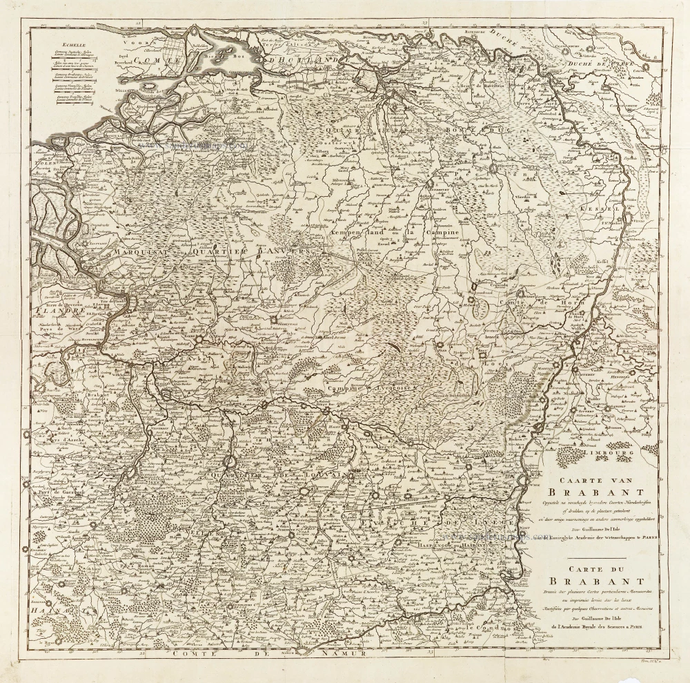
Brabant, by Guillaume De L'Isle, published by J. Dumont. 1729
Jean Dumont
Jean Dumont Baron de Carlscroon (13 January 1667 –13 May 1727) was a French writer and historian. He followed the profession of arms but, not obtaining promotion as rapidly as he expected, left the service and travelled through different parts of Europe. He stopped in Holland intending to publish an account of his travels. But in the interval, at the request of his bookseller, he wrote and published several pamphlets, which were eagerly sought after, owing to the abrupt manner in which he treated the ministry of France. Thus deprived of all hope of employment in his own country, he thought of forming a permanent establishment in Holland and commenced a course of lectures on public law. The project succeeded far beyond his expectations, and some valuable compilations he published in the same period made him well-known in other countries. The emperor appointed him his historiographer and, some time afterwards, conferred on him the title of Baron de Carlscroon. He died in Vienna. (Wikipedia)
Dumont was also the author of Histoire Militaire du prince Eugène de Savoie... published in two volumes in Den Haag in 1729.
Guillaume Delisle (Paris, 1675 – 1726)
Guillaume Delisle (de L’Isle), one of the key figures in the development of French cartography, is the son of Claude Delisle, a cartographer, and the half-brother of astronomers Joseph-Nicolas Delisle and Louis de l'Isle de la Croyère.
While his father has to be given credit for educating Guillaume, the boy showed early signs of being an exceptional talent. He soon contributed to the family workshop by drawing maps for his father's historical works. To perfect his skills, Guillaume Delisle became the student of the astronomer Jean-Dominique Cassini. Early on, he produced high-quality maps, the first being his Carte de la Nouvelle-France et des Pays Voisins in 1696. Delisle's first atlas appeared around 1700, and in 1702 he became a member of the French Académie Royale des Sciences. He taught geography to the young Louis XV, and in 1718 he received the title of Premier Géographe du Roi. On a commission from Peter the Great, he produced a map of the Caspian Sea, a region barely known. Many of the place names he gave are still in use. His Carte de la Louisiane et du cours du Mississippi (1718) is the first detailed map of this region.
A six-year-long plagiarism trial pits Delisle against Jean-Baptiste Nolin, cartographer. It is Nolin, the real plagiarist, who loses.
Delisle has remained famous for his astronomical-based corrections and the completeness of its topography. The high scientific quality of the work produced by the Delisle family contrasted with the workshop of Sanson. While Sanson knowingly published outdated facts and mistakes, Delisle constantly updated his maps to reflect widening knowledge of the world.
Caarte van Brabant - Carte du Brabant.
Item Number: 29338 Authenticity Guarantee
Category: Antique maps > Europe > Belgium
Old, antique map of Brabant, by Guillaume De L'Isle, published by J. Dumont.
Title: Caarte van Brabant - Carte du Brabant.
Opgestelt na verscheyde bysondere Caarten Handschriften of drukken op de plaatsen geteekent en door eenige waarnemingen en andere aanmerklinge opgeheldert.
Door Guillaume De l'Isle van de Koninglyke Academie der Wetenschappen te Parys.
Cartographer: Guillaume De L'Isle.
Engraver: Jan van Huchtenburg.
Date: 1729.
Copper engraving, printed on paper from two plates, joined.
Map size: 625 x 635mm (24.61 x 25 inches).
Sheet size: 670 x 690mm (26.38 x 27.17 inches).
Verso: Blank.
Condition: Folds as issued, excellent.
Condition Rating: A+.
From: Dumont. Histoire militaire du prince Eugène de Savoie... Den Haag, Vander Kloot, 1729.
Jean Dumont
Jean Dumont Baron de Carlscroon (13 January 1667 –13 May 1727) was a French writer and historian. He followed the profession of arms but, not obtaining promotion as rapidly as he expected, left the service and travelled through different parts of Europe. He stopped in Holland intending to publish an account of his travels. But in the interval, at the request of his bookseller, he wrote and published several pamphlets, which were eagerly sought after, owing to the abrupt manner in which he treated the ministry of France. Thus deprived of all hope of employment in his own country, he thought of forming a permanent establishment in Holland and commenced a course of lectures on public law. The project succeeded far beyond his expectations, and some valuable compilations he published in the same period made him well-known in other countries. The emperor appointed him his historiographer and, some time afterwards, conferred on him the title of Baron de Carlscroon. He died in Vienna. (Wikipedia)
Dumont was also the author of Histoire Militaire du prince Eugène de Savoie... published in two volumes in Den Haag in 1729.
Guillaume Delisle (Paris, 1675 – 1726)
Guillaume Delisle (de L’Isle), one of the key figures in the development of French cartography, is the son of Claude Delisle, a cartographer, and the half-brother of astronomers Joseph-Nicolas Delisle and Louis de l'Isle de la Croyère.
While his father has to be given credit for educating Guillaume, the boy showed early signs of being an exceptional talent. He soon contributed to the family workshop by drawing maps for his father's historical works. To perfect his skills, Guillaume Delisle became the student of the astronomer Jean-Dominique Cassini. Early on, he produced high-quality maps, the first being his Carte de la Nouvelle-France et des Pays Voisins in 1696. Delisle's first atlas appeared around 1700, and in 1702 he became a member of the French Académie Royale des Sciences. He taught geography to the young Louis XV, and in 1718 he received the title of Premier Géographe du Roi. On a commission from Peter the Great, he produced a map of the Caspian Sea, a region barely known. Many of the place names he gave are still in use. His Carte de la Louisiane et du cours du Mississippi (1718) is the first detailed map of this region.
A six-year-long plagiarism trial pits Delisle against Jean-Baptiste Nolin, cartographer. It is Nolin, the real plagiarist, who loses.
Delisle has remained famous for his astronomical-based corrections and the completeness of its topography. The high scientific quality of the work produced by the Delisle family contrasted with the workshop of Sanson. While Sanson knowingly published outdated facts and mistakes, Delisle constantly updated his maps to reflect widening knowledge of the world.
Related items

Novissima et Accuratissima Brabantiae Ducatus Tabula. 1638
Brabant by Henricus Hondius, published by J. Janssonius.
[Item number: 19012]

Brabantia Ducatus 1664-65
Brabant by Willem Blaeu
[Item number: 20955]

First edition, woodcut
Descrittione particulare di Brabante. 1567
Brabant by Lodovico Guicciardini.
[Item number: 29504]

Le Brabant Hollandois et Autrichien. 1747
Northwest Brabant by G.L. Le Rouge.
[Item number: 30255]
Very rare first state.
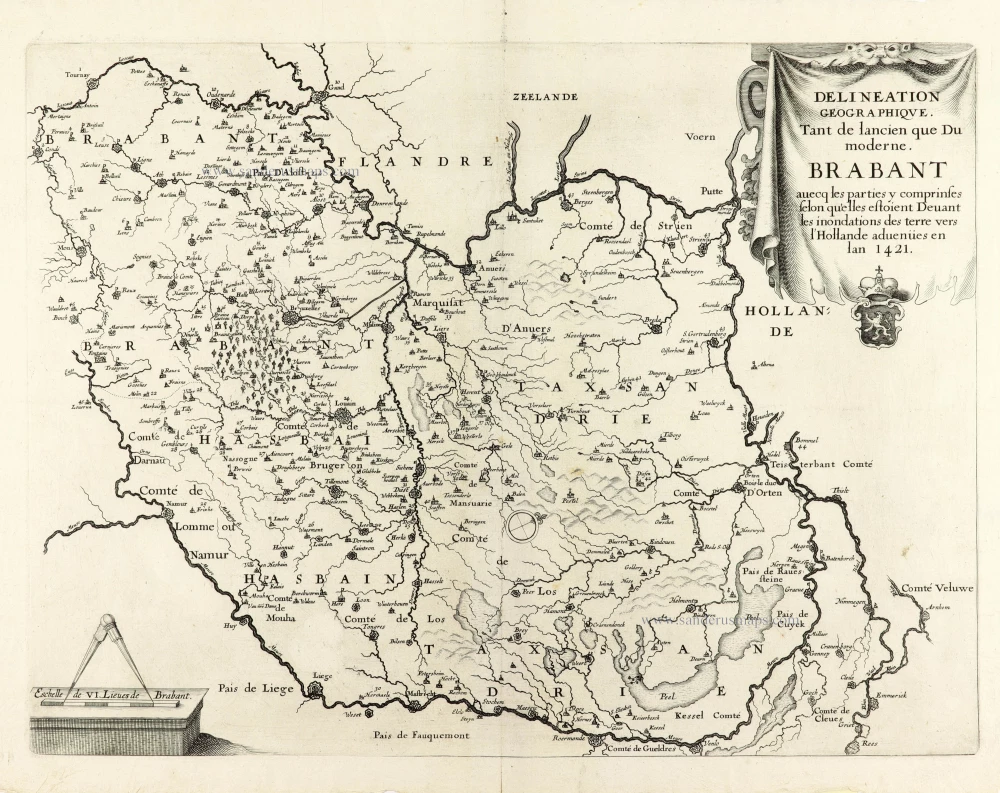
Delineation Geographique. Tant de lancien que Du moderne. Brabant avecq les parties y comprinses selon qu'elles estoient Devant les inondations des terre vers l'Hollande advenües en lan 1421. 1637
Historical map of Brabant by Christophe Butkens.
[Item number: 30291]

Partie Septentrionale du Duché de Brabant où se trouvent les Mairies de Bosleduc de Turnhout, de Santhoven, d'Herentals, les Marquisats de Berg-op-Zoom, et du St Empire, la Baronie de Bréda partie de la Seigneurie de Malines, et de l'Evêché de Lyége &c. 1757
Southern Brabant par Robert de Vaugondy.
[Item number: 30403]

Menapii. Dioecese de l'Archev[es]ché de Malines. Partie meridionale du Duché de Brabant, ou sont les quartiers de Louvain, et du Brusselles; et la seign[eu]rie de Malines. 1679-1710
Historical map of Southern Brabant, by Guillaume Sanson, published by P. Mariette.
[Item number: 30520]

Tabula Ducatus Brabantiae continens Marchionatum Sacri Imperiii et Dominium Mechliniense 1670-71
Brabant by Frederick De Wit.
[Item number: 30526]

[No Title] 1630
Brabant by Gerard Mercator.
[Item number: 30943]

Early map of the Low Countries, 1561-1574
Fiandra, Brabantia, et Holanda Nuova. 1574
Low Countries by Girolamo Ruscelli.
[Item number: 31083]

Brabantia. 1618
Brabant by Petrus Bertius, published by Jodocus Hondius II.
[Item number: 31591]

Le Duché de Brabant qui comprend les quartiers de Louvan, Brusselles, Anvers et Bos le Duc 1692
Northern Brabant, by N. Sanson, so-called published by Hubert Jaillot. (Pirated edition by Pierre Mortier).
[Item number: 31721]

Carte de Brabant. 1633
Brabant by Chistophe Tassin.
[Item number: 31930]

Ducatus Brabantiae Nova Tabula in qua Lovanii Bruxxellarum March S. Imperii Sylvae Ducis et Mechliniae Dominia in sua suasq. minores Ditiones subdivisa ostenduntur. c. 1720
Brabant, by J.B. Homann.
[Item number: 32467]

Ducatus Brabantiae Tabula continens Sacri Imperii Marchionatum et Dominium Mechliniense de novo accurate emendata. c. 1704-1706
Brabant by Johannes Danckerts.
[Item number: 32498]