
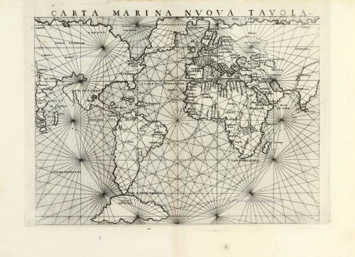
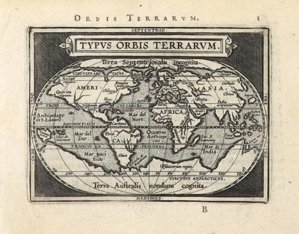
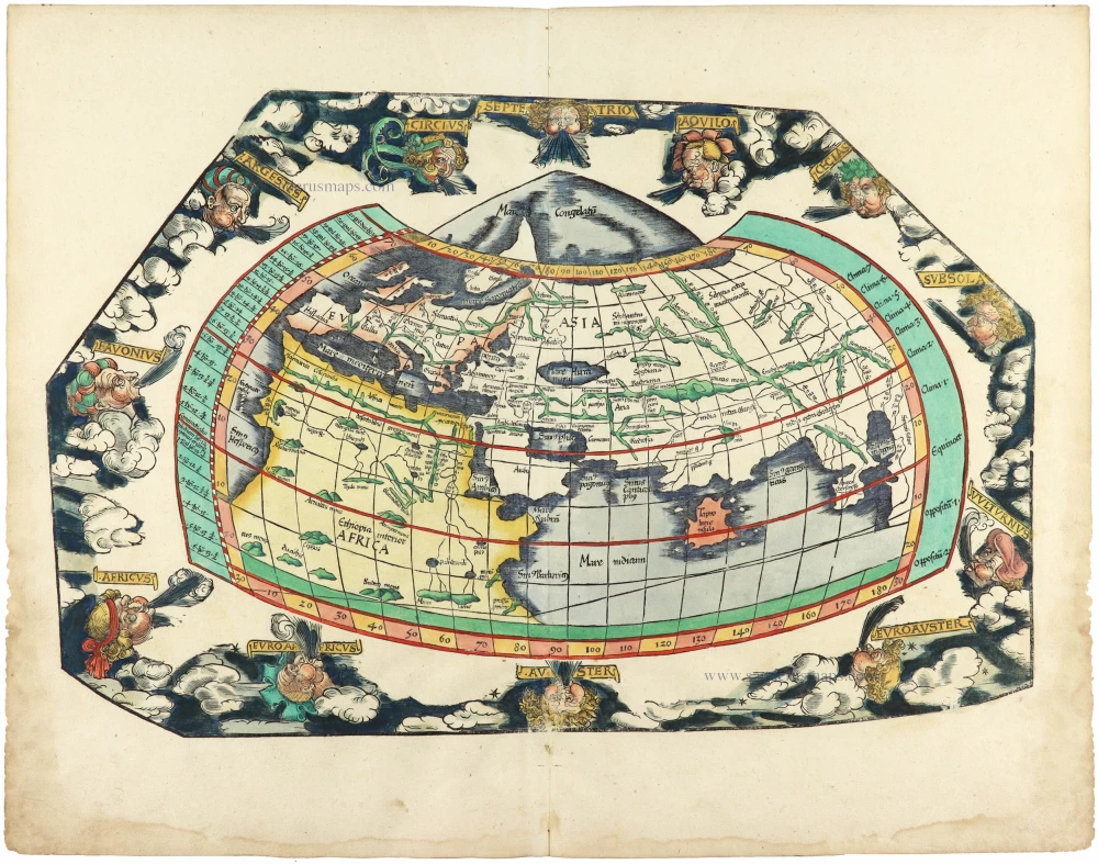
World chart by Girolamo Ruscelli. 1561


Giacomo Gastaldi (c. 1500 – 1566)
Giacomo Gastaldi was born in Villafranca, in Piedmont, to a wealthy family. Although he is considered one of the greatest cartographers of the sixteenth century, the events of his life and his professional training in the field of cartography are unknown to us until he arrives in Venice, where, in 1539, he obtained a perpetual printing privilege from the Venetian Senate.
One of the first Venetian contacts took place with the geographer and humanist Giovanni Battista Ramusio, with whom he collaborated. At the beginning of the 1540s, Gastaldi was already an established cartographer and began to work on a series of maps first published separately and then included in the Italian edition of Ptolemy's Geography of 1548 and others made from scratch.
By the 1540s, he had developed his distinctive style of copper engraving for his increasingly prolific output of maps. His maps were used as a source by many mapmakers, including Camocio, Bertelli, Forlani, Ramusio, Cock, Luchini and Ortelius.
With the support of his influential friendships, Gastaldi also obtained public positions: in 1549, the Council of Ten commissioned him to make a large map of Africa, for a wall from the armoury in the Doge's Palace and, again for the same room, one map of Asia and one of North America.
It is difficult to quantify the number of maps he produced; more than a hundred have been attributed to him.
Paolo Forlani collaborated for a long time with Gastaldi and published numerous counterfeits and not authorized editions.
Gastaldi died in Venice on 14 October 1566.
Girolamo Ruscelli (1504 (1518?) -1566)
Girolamo Ruscelli was an Italian mathematician and cartographer who worked in Venice in the early 16th century. He was also an alchemist who wrote pseudonymously as Alessio Piemontese.
He published a translation of the Geografia of Ptolemy, printed in Venice by Vincenzo Valgrisi in 1561. It was a quarto edition with Ptolemaic and modern maps. The engravers may have been the brothers Giulio and Livio Sanuto. Among the 69 copperplate maps were 40 based on maps by Giacomo Gastaldi. The maps were re-issued in 1562, 1564, 1574 and 1598.
Carta Marina Nuova Tavola.
Item Number: 30380 Authenticity Guarantee
Category: Antique maps > World
World chart by Girolamo Ruscelli.
Title: Carta Marina Nuova Tavola.
Cartographer: Giacomo Gastaldi.
Engraver: Giulo & Livio Sanuto.
Date of the first edition: 1561.
Date of this map: 1561.
Copper engraving, printed on paper.
Image size: 180 x 245mm (7.09 x 9.65 inches).
Sheet size: 230 x 320mm (9.06 x 12.6 inches).
Verso: Italian text.
Condition: Sharp impression, excellent.
Condition Rating: A+.
Giacomo Gastaldi (c. 1500 – 1566)
Giacomo Gastaldi was born in Villafranca, in Piedmont, to a wealthy family. Although he is considered one of the greatest cartographers of the sixteenth century, the events of his life and his professional training in the field of cartography are unknown to us until he arrives in Venice, where, in 1539, he obtained a perpetual printing privilege from the Venetian Senate.
One of the first Venetian contacts took place with the geographer and humanist Giovanni Battista Ramusio, with whom he collaborated. At the beginning of the 1540s, Gastaldi was already an established cartographer and began to work on a series of maps first published separately and then included in the Italian edition of Ptolemy's Geography of 1548 and others made from scratch.
By the 1540s, he had developed his distinctive style of copper engraving for his increasingly prolific output of maps. His maps were used as a source by many mapmakers, including Camocio, Bertelli, Forlani, Ramusio, Cock, Luchini and Ortelius.
With the support of his influential friendships, Gastaldi also obtained public positions: in 1549, the Council of Ten commissioned him to make a large map of Africa, for a wall from the armoury in the Doge's Palace and, again for the same room, one map of Asia and one of North America.
It is difficult to quantify the number of maps he produced; more than a hundred have been attributed to him.
Paolo Forlani collaborated for a long time with Gastaldi and published numerous counterfeits and not authorized editions.
Gastaldi died in Venice on 14 October 1566.
Girolamo Ruscelli (1504 (1518?) -1566)
Girolamo Ruscelli was an Italian mathematician and cartographer who worked in Venice in the early 16th century. He was also an alchemist who wrote pseudonymously as Alessio Piemontese.
He published a translation of the Geografia of Ptolemy, printed in Venice by Vincenzo Valgrisi in 1561. It was a quarto edition with Ptolemaic and modern maps. The engravers may have been the brothers Giulio and Livio Sanuto. Among the 69 copperplate maps were 40 based on maps by Giacomo Gastaldi. The maps were re-issued in 1562, 1564, 1574 and 1598.
Related items
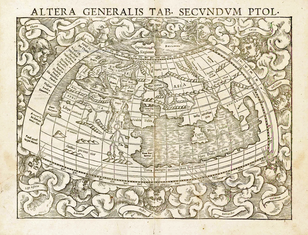
Altera Generalis Tab. Secundum Ptol. 1559
Ptolemaic world by Sebastian Münster
[Item number: 11981]
Rare first edition
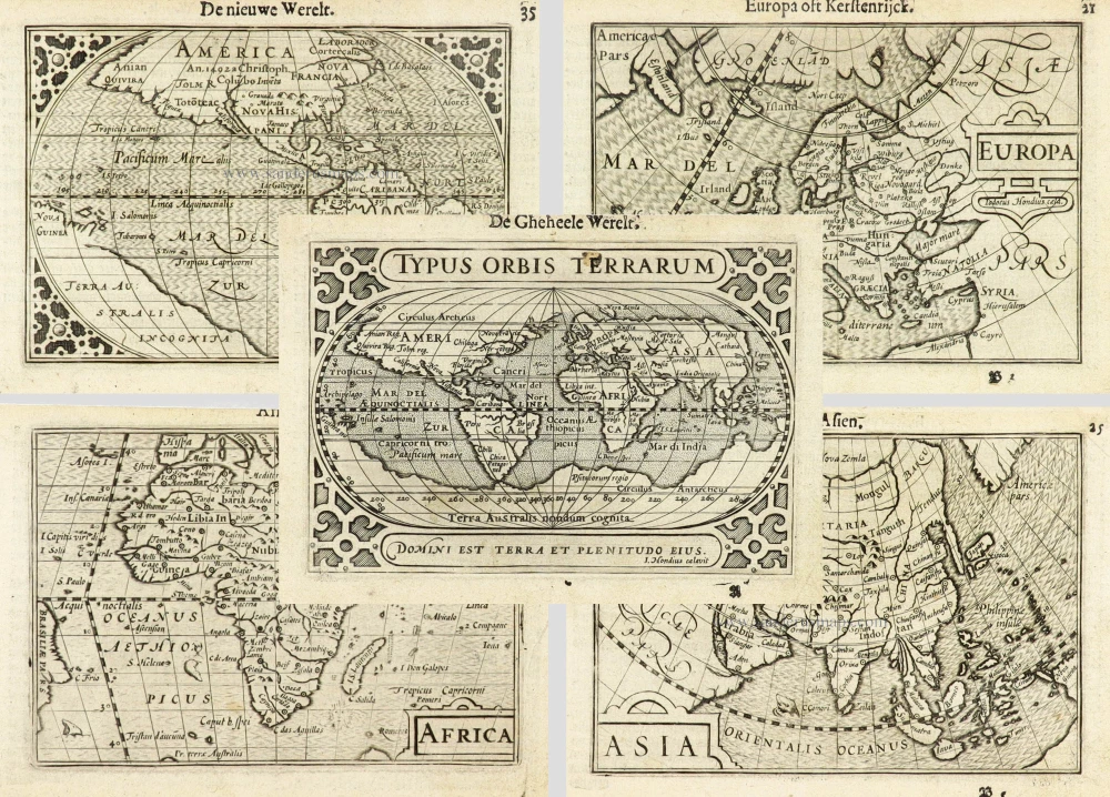
Typus Orbis Terrarum. [in set with:] America, [and] Europa, [and] Africa, [and] Asia. 1598
World and Continents by Barent Langenes & Cornelis Claesz. Five maps.
[Item number: 16457]

Rare variant.
Cosmographia Universalis. 1592
World map by H. Bünting - D.A. Veleslavina.
[Item number: 26356]

Nouvelle Mappe Monde Dediee au Progres de nos Connoissances. 1776-79
World by Francesco Santini.
[Item number: 26946]

Universi Orbis Descriptio. 1597
World by Giovanni Magini
[Item number: 27837]
The most mystical world map of all time.
[No title] 1560-1600
Daniel's Dream Map. The Wittenberg world map.
[Item number: 28159]

Mappemonde en deux Hémisphères. c. 1797
World map, double hemisphere by Pierre Grégoire Chanlaire.
[Item number: 28209]

Mappe-Monde Physique. c. 1797
World map, double hemisphere by Pierre Grégoire Chanlaire.
[Item number: 28210]
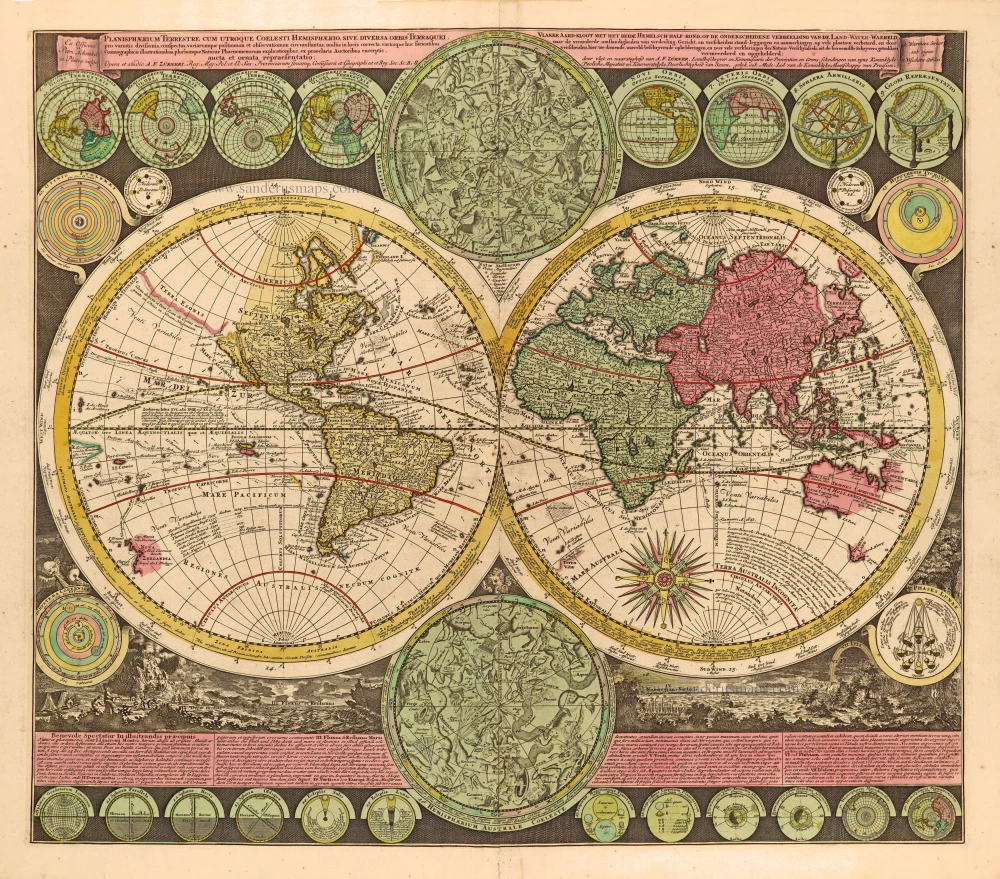
Planisphaerium Terrestre cum utroque Coelesti Hemisphaerio, sive Diversa Orbis Terraquei, c. 1700
World by Zürner A.F., double hemisphere.
[Item number: 28229]
First edition, scarce
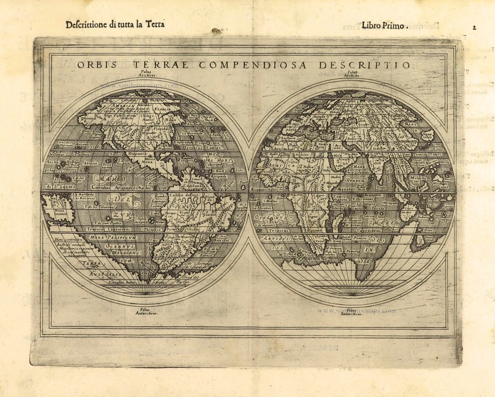
Orbis Terrae Compendiosa Descriptio. 1598
World by Giuseppe Rosaccio, double hemisphere.
[Item number: 28289]

Ptolemaei Cognita. 1598
Ptolemaic world map by Giuseppe Rosaccio.
[Item number: 28290]
The engraving and layout and elegance of decoration are all of the highest standards.
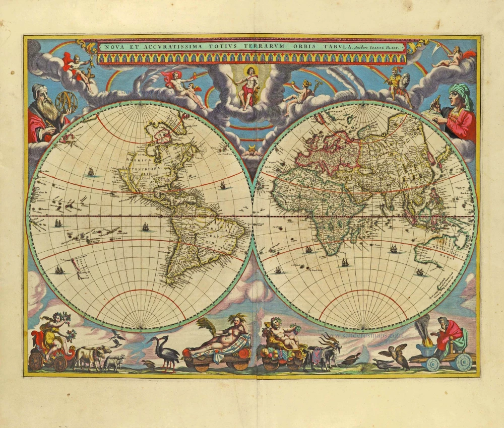
Nova Et Accuratissima Totius Terrarum Orbis Tabula. 1659
World by Joan Blaeu, double hemisphere.
[Item number: 28336]
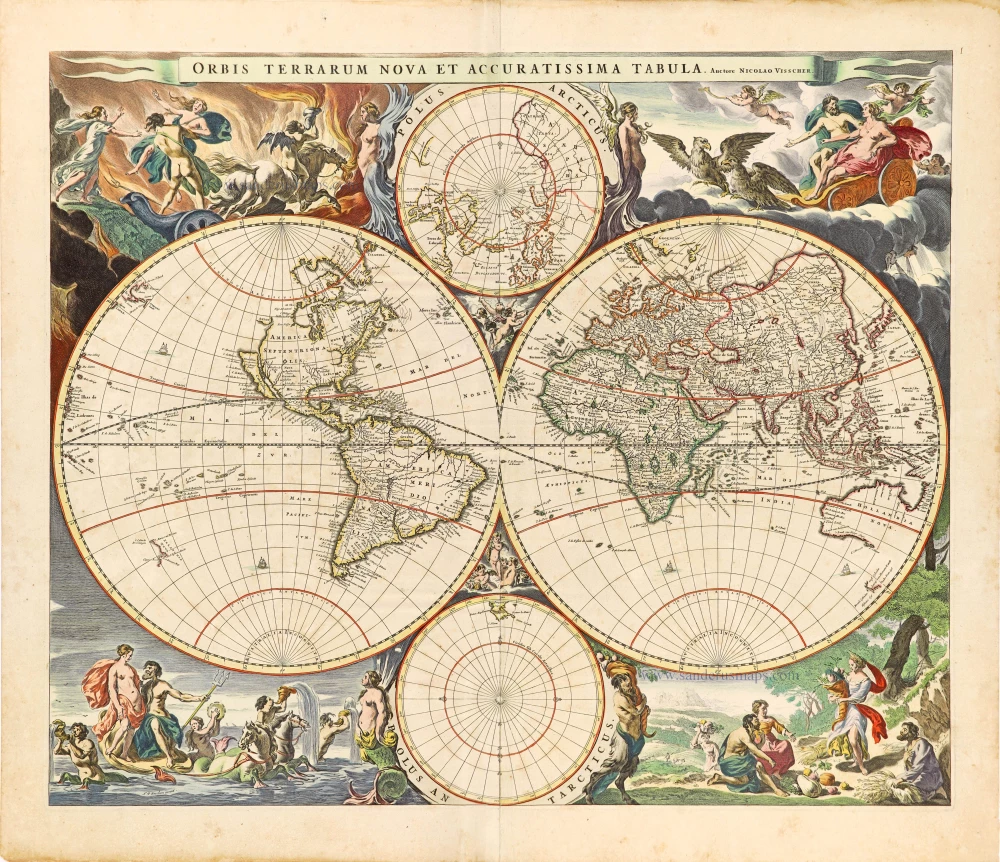
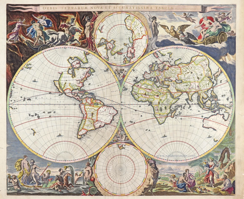
Orbis Terrarum Nova et Accuratissima Tabula. c. 1678
World by Nicolaas Visscher, double hemisphere.
[Item number: 28628]

A fine ornate example of the decorative cartography of the time.
Nova Totius Terrarum Orbis Geographica ac Hydrographica Tabula. Auct: Henr: Hondio. 1641
Double-hemisphere world map by Henricus Hondius.
[Item number: 28768]

Descrittione Del Mappamondo. 1572
World by Porcacchi Tommaso.
[Item number: 28910]
Luxury colouring.
Orbis Terrarum Nova et Accuratissima Tabula. c. 1678
Double-hemisphere world map, by Nicolaas Visscher I.
[Item number: 28934]
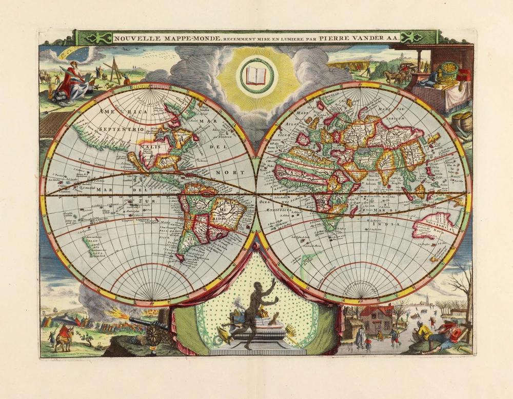
Nouvelle Mappe-Monde, 1710
World by Pieter Van der Aa, double hemisphere.
[Item number: 29136]

Nova Orbis Tabula in Lucem Edita, A. F. De Wit. c. 1690
World by Frederik De Wit, double hemisphere.
[Item number: 29231]
Superb world set.
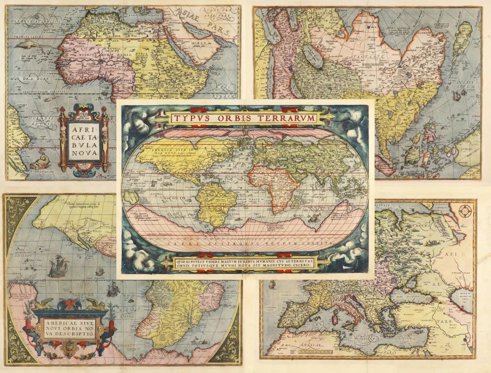
Typus Orbis Terrarum [in set with] Africae Tabula Nova [and] Americae sive Novi Orbis, Nova Descriptio [and] Asiae Nova Descriptio [and] Europae. 1584
Abraham Ortelius, 1584 World and Continents
[Item number: 29259]

Mapmonde ou description generale du Globe Terrestre. 1713
World map by Zacharias Châtelain.
[Item number: 29555]
Typus Orbis Terrarum. 1589
The world by Abraham Ortelius / Philippe Galle.
[Item number: 29605]

Rare original colour.
Typus Orbis Terrarum - Globus Terrestris. 1609
Two world maps by A. Ortelius, published by J.B. Vrients.
[Item number: 29861]

Mappe-Monde 1766-1780
World map by Louis Brion de la Tour, published by L.C Desnos.
[Item number: 30100]
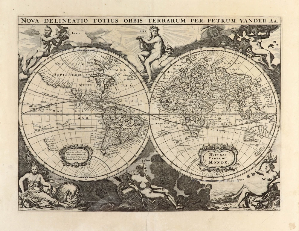
Nova Delineatio Totius Orbis Terrarum per Petrum Van der Aa. - Nouveau Carte du Monde. 1702
World by Pieter Van der Aa - double hemisphere.
[Item number: 30150]
Rare 1525 edition in nice old colour.
[No title] 1525
Ptolemaic world by Lorenz Fries after Martin Waldseemüller.
[Item number: 30649]