
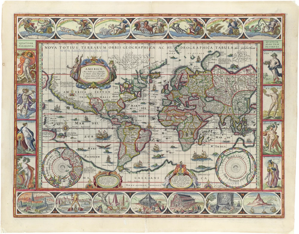
World by Pieter Van der Aa, double hemisphere. 1710
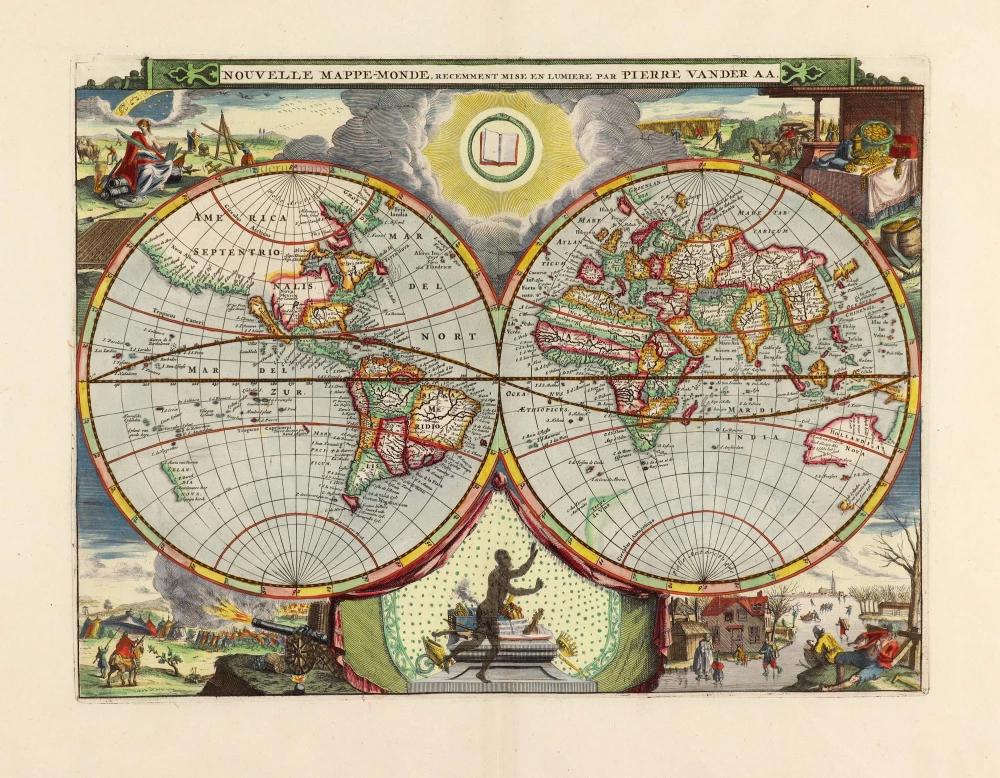

World map in two hemispheres with in the corners allegorical representations of the four elements/seasons (spring/air, summer/fire, autumn/earth, and winter/water). At the top centre, an ouroboros - an ancient symbol depicting a serpent or dragon eating his own tail - and at the bottom, a shadow running in front of symbols of power, wealth and arts.
Pieter van der Aa (Leiden, 1659-1733)
Pieter van der Aa was already in 1682 owner of a bookshop and auction house. During his life, he has published an enormous amount of printed material.
After 1700, van der Aa increasingly specialised in books on geography and travel.
He published composite atlases, a series of geographical descriptions of European countries, and some very spectacular works. Between 1706 and 1708 he published the Naauweurige versameling der gedenkwaardigste zee- en land-reysen, in 28 volumes.
Many of Van der Aa’s publications are richly illustrated with maps and plates. He took over many copperplates and prints from other publishers such as Carel Allard and Frederik De Wit. The composite atlases that appeared from his workshop contain a curious mixture of his own material, copies of maps from other publishers, and reprints made from old copper plates, now with his own imprint.
The Galérie agréable du monde, was completed in 1729, and comprised 66 parts, bound in 27 volumes. Van der Aa presented it as a good investment; after publication, the antiquarian value of the work would double, the more so since it was printed in a limited edition of only one hundred copies.
Nouvelle Mappe-Monde,
Item Number: 29136 Authenticity Guarantee
Category: Antique maps > World
Old, antique world map in two hemispheres, by Pieter Van der Aa.
Title: Nouvelle Mappe-Monde,
recemment mise en lumiere par Pierre van der Aa.
Engraver: Romein de Hooghe.
Date of the first edition: 1710.
Date of this map: 1710.
Copper engraving, printed on paper.
Map size: 260 x 345mm (10.24 x 13.58 inches).
Sheet size: 380 x 470mm (14.96 x 18.5 inches).
Verso: Blank.
Condition: Original coloured, excellent.
Condition Rating: A+.
From: Les Indes Orientales et Occidentales, et autres lieux; Représentés en très-belles Figures, qui montrent au naturel les Peuples, Moeurs, Religions, Fêtes, Sacrifices, Mosquées, Idoles, Richesse, Ceremonies, Festins, Tribunaux, Supplices et Esclavages, ... etc. Par le Sr. Romein de Hooge. A Leide, Chez Pierre Vander Aa, Marchand Libraire. [1710]. (Koeman I, p. 9, Aa3) RARE.
World map in two hemispheres with in the corners allegorical representations of the four elements/seasons (spring/air, summer/fire, autumn/earth, and winter/water). At the top centre, an ouroboros - an ancient symbol depicting a serpent or dragon eating his own tail - and at the bottom, a shadow running in front of symbols of power, wealth and arts.
Pieter van der Aa (Leiden, 1659-1733)
Pieter van der Aa was already in 1682 owner of a bookshop and auction house. During his life, he has published an enormous amount of printed material.
After 1700, van der Aa increasingly specialised in books on geography and travel.
He published composite atlases, a series of geographical descriptions of European countries, and some very spectacular works. Between 1706 and 1708 he published the Naauweurige versameling der gedenkwaardigste zee- en land-reysen, in 28 volumes.
Many of Van der Aa’s publications are richly illustrated with maps and plates. He took over many copperplates and prints from other publishers such as Carel Allard and Frederik De Wit. The composite atlases that appeared from his workshop contain a curious mixture of his own material, copies of maps from other publishers, and reprints made from old copper plates, now with his own imprint.
The Galérie agréable du monde, was completed in 1729, and comprised 66 parts, bound in 27 volumes. Van der Aa presented it as a good investment; after publication, the antiquarian value of the work would double, the more so since it was printed in a limited edition of only one hundred copies.
Related items
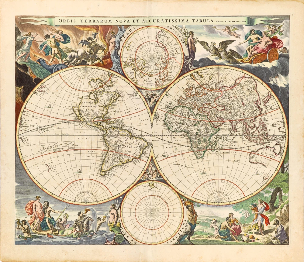
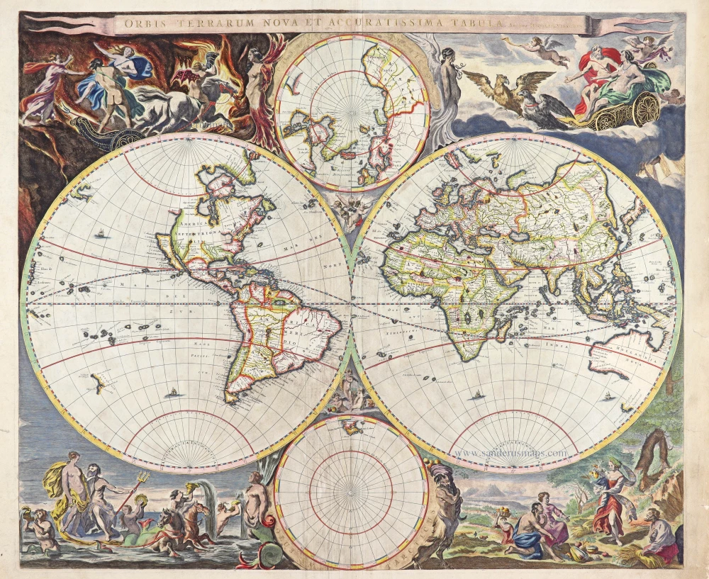
Orbis Terrarum Nova et Accuratissima Tabula. c. 1678
World by Nicolaas Visscher, double hemisphere.
[Item number: 28628]

A fine ornate example of the decorative cartography of the time.
Nova Totius Terrarum Orbis Geographica ac Hydrographica Tabula. Auct: Henr: Hondio. 1641
Double-hemisphere world map by Henricus Hondius.
[Item number: 28768]

Descrittione Del Mappamondo. 1572
World by Porcacchi Tommaso.
[Item number: 28910]
Luxury colouring.
Orbis Terrarum Nova et Accuratissima Tabula. c. 1678
Double-hemisphere world map, by Nicolaas Visscher I.
[Item number: 28934]
Nouvelle Mappe-Monde, 1710
World by Pieter Van der Aa, double hemisphere.
[Item number: 29136]

Nova Orbis Tabula in Lucem Edita, A. F. De Wit. c. 1690
World by Frederik De Wit, double hemisphere.
[Item number: 29231]
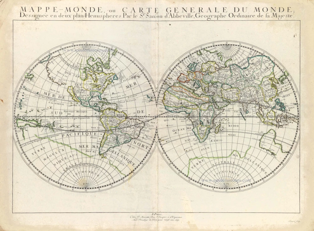
Mappe-Monde, ou Carte Generale du Monde, 1652
Double hemisphere world map by Nicolas Sanson.
[Item number: 29612]

Mercator projection
Discorso Intorno alla Carta da Navigare. 1590
World by Thomaso Porcacchi.
[Item number: 29786]

Rare original colour.
Typus Orbis Terrarum - Globus Terrestris. 1609
Two world maps by A. Ortelius, published by J.B. Vrients.
[Item number: 29861]

Mappe-Monde 1766-1780
World map by Louis Brion de la Tour, published by L.C Desnos.
[Item number: 30100]
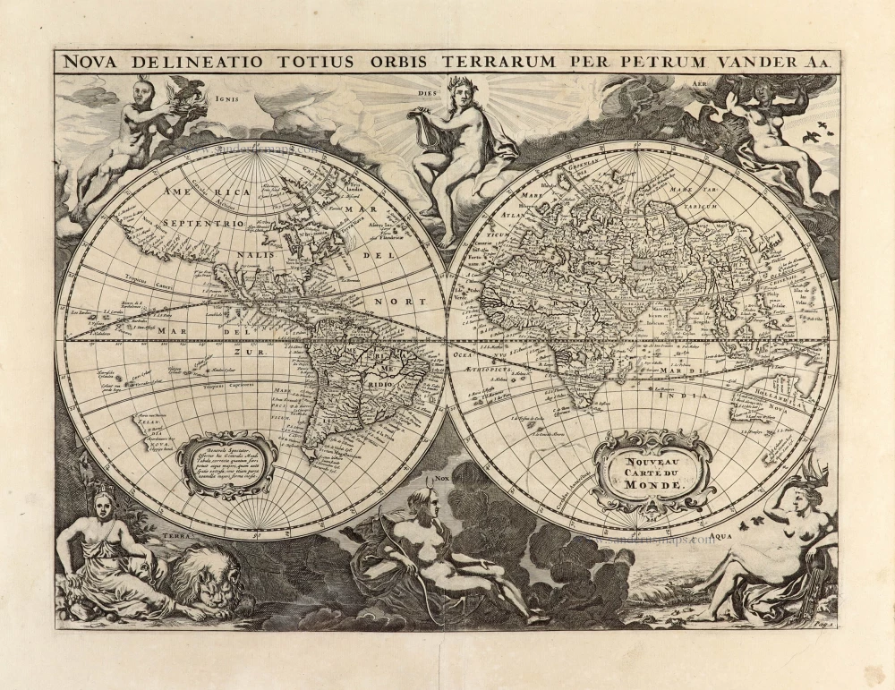
Nova Delineatio Totius Orbis Terrarum per Petrum Van der Aa. - Nouveau Carte du Monde. 1702
World by Pieter Van der Aa - double hemisphere.
[Item number: 30150]

'One of the supreme examples of map maker's art' (Shirley)
Nova Totius Terrarum Orbis Geographica ac Hydrographica. 1643
World by Willem Blaeu, in Mercator projection.
[Item number: 30271]

Superb old colouring, heightened with gold.
Orbis Terrarum Tabula Recens Emendata Et In Lucem Edita 1714
World - Double Hemisphere, by Daniel Stoopendaal
[Item number: 30635]
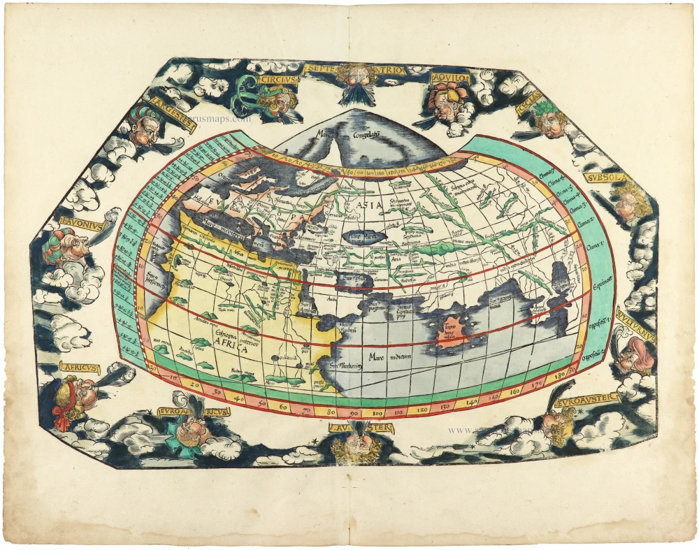
Rare 1525 edition in nice old colour.
[No title] 1525
Ptolemaic world by Lorenz Fries after Martin Waldseemüller.
[Item number: 30649]
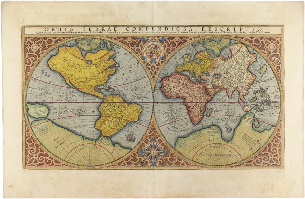
Orbis Terrae Compendiosa Descriptio. 1613
World by Mercator Rumold, double hemisphere.
[Item number: 30942]

Mappe-Monde Geo-Hydrographique, ou Description Generale du Globe Terrestre et Aquatique en Deux Plans-Hemispheres ... 1692
World map by Nicolas Sanson, so-called published by Hubert Jaillot. (Pirated edition by Pierre Mortier).
[Item number: 31136]

Typus Orbis Terrarum. 1618
World by Petrus Bertius, published by Jodocus Hondius II.
[Item number: 31520]

Gottfried's first edition 1631
[no title] 1631
Willem C. Schouten, world map published by Gottfried.
[Item number: 31560]

Rare first edition
[no title] 1618
World map in two hemispheres by Willem W. Schouten.
[Item number: 31601]

An Essay of a New and Compact Map, containing the known parts of the Terrestrial Globe. 1750
World map by Jacques-Nicolas Bellin, published by A.F. Prévost.
[Item number: 31883]

Beautiful example of this important world map
Typus Orbis Terrarum. 1584
World by Abraham Ortelius.
[Item number: 32090]

Planiglobii Terrestris cum Utroq Hemisphaerio Caelesti Generalis Repraesentatio. c. 1720
World by Homann J.B., double hemisphere.
[Item number: 32099]

Early Mercator projection
Universi Orbis Descriptio Ad Usum Navigantium. 1597
World by Giovanni Magini.
[Item number: 32281]

Carta Marina Nuova Tavola. 1574
World chart by Girolamo Ruscelli.
[Item number: 32432]

Orbis Descriptio. 1574
World in two hemisperes, by Girolamo Ruscelli.
[Item number: 32433]

Rare first state of Danckerts beautiful world map
Nova Totius Terrarum Orbis Tabula.. c. 1680
Double hemisphere world map by Justus Danckerts
[Item number: 32456]

The most mystical world map of all time.
[No title] 1560-1600
Daniel's Dream Map. The Wittenberg world map by Hanss Luft.
[Item number: 32507]
'One of the supreme examples of map maker's art' (Shirley)
Nova Totius Terrarum Orbis Geographica ac Hydrographica. 1635
World by Willem Blaeu, in Mercator projection.
[Item number: 32683]

Mappa Mondo O Vero Carta Generale Del Globo Terestre 1677
World in two hemisphers by Giovanni De Rossi, after Nicolas Sanson.
[Item number: 32885]

Typus Orbis Terrarum. 1618
World by Petrus Bertius.
[Item number: 33183]
new