Antique maps catalogue
- All recent additions
-
Antique maps
- Polar maps
- World
-
Europe
- Europe Continent
- Belgium
- Belgium - Cities
- The Low Countries
- The Netherlands
- The Netherlands - Cities
- Luxembourg
- France
- France - Cities
- Germany
- Germany - Cities
- Austria
- Italy
- Italy - Cities
- Spain and Portugal
- Greece & Greek Islands
- Switzerland
- British Isles
- British Isles - Cities
- Northern Europe
- Central Europe
- Eastern Europe
- Southeastern Europe
- America
- Asia
- Africa
- Mediterranean Sea
- Australia
- Oceans
- Celestial Maps
- Curiosities
- Title Pages
- Books
- Medieval manuscripts
- Prints

Western England, by Henricus Hondius. 1641
Eboracum, Lincolnia, Derbia, Statfordia, Notinghamia, Lecestria,...
[Item number: 26247]

Wiltshire by J. Blaeu. 1645
Wiltonia sive Comitatus Wiltoniensis; Anglis Wil Shire.
[Item number: 29771]

Brecknock, by J. Blaeu. 1654-1662
Comitatus Brechiniae; Breknoke.
[Item number: 7082]

British Isles, by Van Keulen Johannes. 1697-1709
Paskaart van 't Canaal Engelandt Schotlandt en Yrland
[Item number: 5817]

Cardiganshire, by J. Blaeu. 1654-1662
Ceretica; sive Cardiganensis Comitatus; Anglis Cardigan Shire
[Item number: 7548]

Denbigh - Flint by J. Blaeu. 1645
Denbigiensis Comitatus et Comitatus Flintensis.
[Item number: 25811]

Sea chart of the East coast of England & Scotland, by Van Keulen Johannes 1697-1709
Nieuwe Paskaert vande Oost Cust van Engeland en Schotland...
[Item number: 8077]

Holy Island, by Joan Blaeu. 1662
Insula Sacra; vulgo Holy Iland; et Farne
[Item number: 14300]

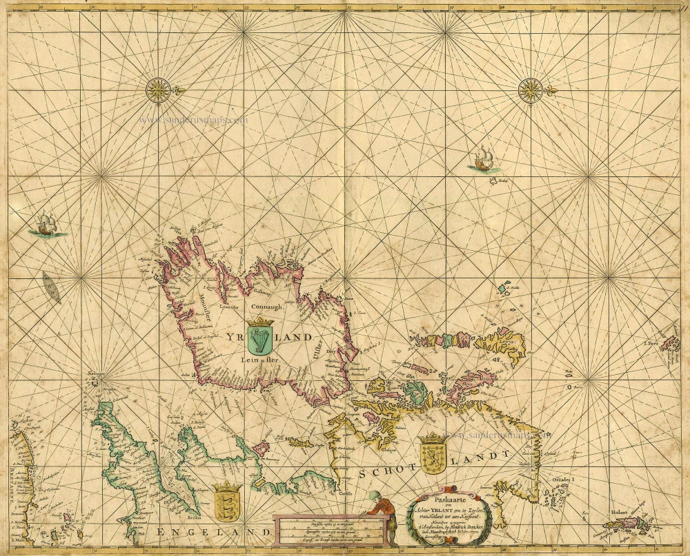
Ireland, by Doncker H. 1686
De Noord-Oost zyde van Yerlandt van Caap de Hoorn-hout tot...
[Item number: 13644]
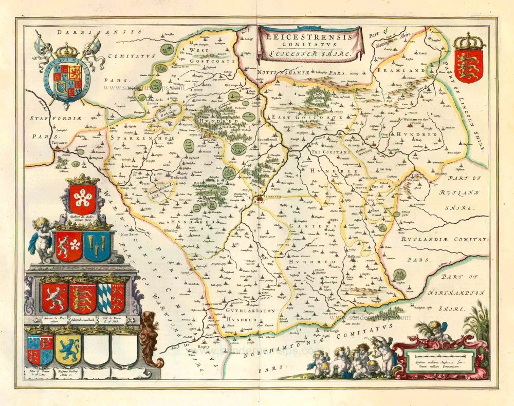
Leicester, by J. Blaeu. 1645
Leicestrensis Comitatus. Leicester Shire.
[Item number: 25801]
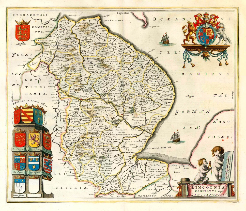
Lincolnshire, by J. Blaeu. 1645
Lincolnia Comitatus. Anglis Lincoln-shire.
[Item number: 25806]

Northumberland, by J. Blaeu. 1645
Comitatus Northumbria; Vernacule Northumberland.
[Item number: 25804]

Nottinghamshire by J. Blaeu. 1645
Comitatus Nottinghamiensis; Nottingham Shire.
[Item number: 25807]

Radnor, by J. Blaeu. 1654-1662
Radnoria Comitatus Radnor Shire
[Item number: 7298]

Rutland, by J. Blaeu. 1654-1662
Rutlandia Comitatus. Rutland Shire.
[Item number: 7506]
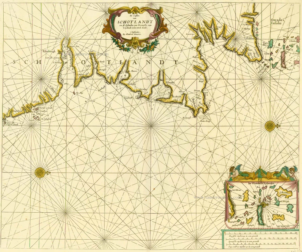
Scotland and Orkney Islands, by Doncker H. 1686
De Custen van Schotlandt en de Eylanden van Orcanese, van 't...
[Item number: 15386]

Shropshire, by J. Blaeu. 1645
Comitatus Salopiensis, Anglice Shropshire.
[Item number: 25809]

Stafford, by J. Blaeu. 1654-1662
Staffordiensis Comitatus; vulgo Stafford Shire
[Item number: 7085]

Suffolk, by Blaeu J. 1662
Suffolcia Vernacule Suffolke
[Item number: 1394]

Surrey by Joan Blaeu. 1662
Surria vernacule Surrey
[Item number: 22812]

The British Isles, by Ortelius A. 1601
Angliae, Scotiae, et Hiberniae, sive Britannicae Insularum...
[Item number: 22869]
British Isles, by Hendrik Doncker. 1665
Paskaarte om achter Yrlant om te Zeylen van Hitlant tot aen...
[Item number: 18567]

The Channel Islands, by J. Blaeu. 1645-48
Sarnia Insula, vulgo Garnsey: et Insula Caesarae, vernacule...
[Item number: 24640]

Oxfordshire by J. Blaeu 1645
Oxonium Comitatus, vulgo Oxford Shire.
[Item number: 29773]

Pembrokeshire and Caermarthen by Joan Blaeu. 1654-1662
Penbrochia Comitatus et Comitatus Caermaridunum
[Item number: 8126]

Satirical (anthropomorphic) map of Ireland. 1869
Ireland.
[Item number: 32190]

Scotland - Carrick (South) by J. Blaeu 1664-65
Carricta Meridionalis. The South part of Carrick.
[Item number: 13069]

Extremely rare Italian Scotland-map
Scotland by an Italian mapmaker, derived from a map by A. Lafreri and Bishop Leslie.
Scotiae nova et accurata descriptio. - Scotia Britannicae Insule...
[Item number: 33066]
new

Scotland by N. Sanson, so-called published by Hubert Jaillot. (Pirated edition by Pierre Mortier). 1692
Le Royaume d'Escosse Divisé en Parties Septentrionale &...
[Item number: 31173]
![Scotia Septentrion. [in set with] Scotia Australis.](https://sanderusmaps.com/assets/IMG/webp/m31537.webp)
Scotland by Petrus Bertius, published by Jodocus Hondius II. 1618
Scotia Septentrion. [in set with] Scotia Australis.
[Item number: 31537]
Scotland by Petrus Bertius, published by Jodocus Hondius II. 1618
Scotia.
[Item number: 31539]
![Scotia - Parte Settentrionale. [in set with:] Parte Meridionale.](https://sanderusmaps.com/assets/IMG/webp/m28661.webp)
Scotland by Vincenzo Coronelli. 1696
Scotia - Parte Settentrionale. [in set with:] Parte Meridionale.
[Item number: 28661]

Scotland, by G. & L. Valck. c. 1700
Regnum Scotiae, seu Pars Septent: Magnae Britanniae Divisa ...
[Item number: 32209]
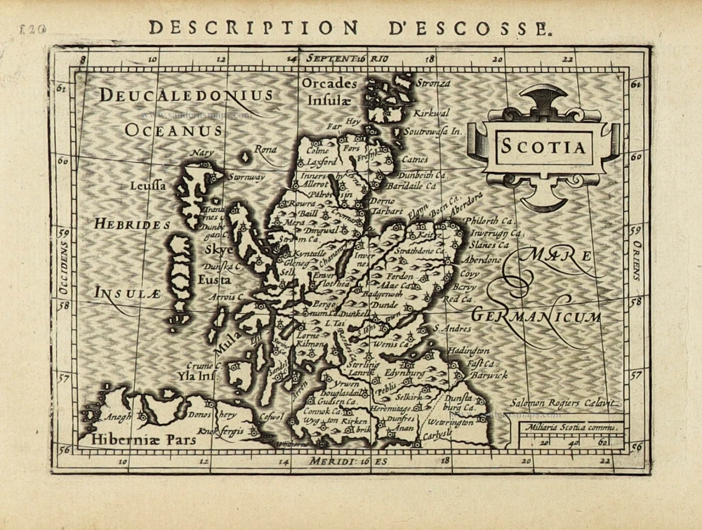
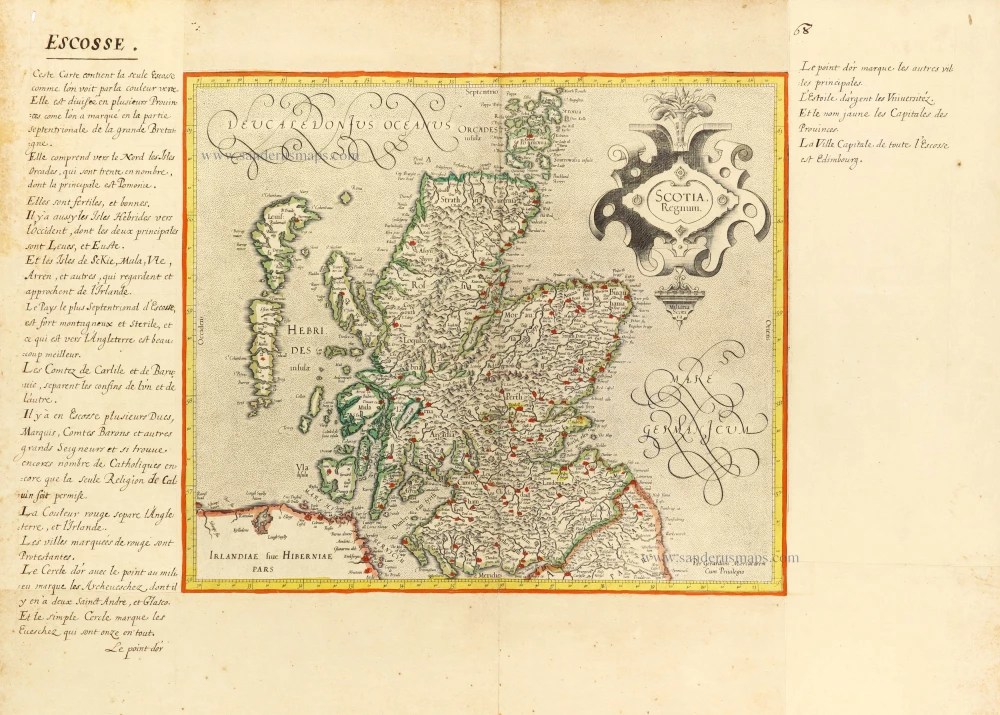
Scotland, by Gerard Mercator. 1633
Scotia Regnum.
[Item number: 32180]
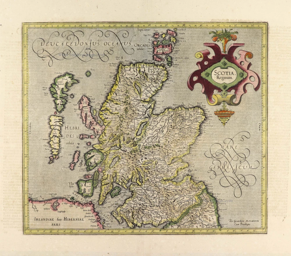
Scotland, by Gerard Mercator. c. 1610-1650
Scotia Regnum.
[Item number: 31015]
![Scotia. - [Above map :] Descrittione del L'Isola di Scotia.](https://sanderusmaps.com/assets/IMG/webp/m28915.webp)
Scotland by Thomaso Porcacchi. 1572
Scotia. - [Above map :] Descrittione del L'Isola di Scotia.
[Item number: 28915]