Antique maps catalogue
- All recent additions
-
Antique maps
- Polar maps
- World
-
Europe
- Europe Continent
- Belgium
- Belgium - Cities
- The Low Countries
- The Netherlands
- The Netherlands - Cities
- Luxembourg
- France
- France - Cities
- Germany
- Germany - Cities
- Austria
- Italy
- Italy - Cities
- Spain and Portugal
- Greece & Greek Islands
- Switzerland
- British Isles
- British Isles - Cities
- Northern Europe
- Central Europe
- Eastern Europe
- Southeastern Europe
- America
- Asia
- Africa
- Mediterranean Sea
- Australia
- Oceans
- Celestial Maps
- Curiosities
- Title Pages
- Books
- Medieval manuscripts
- Prints

England and Wales by N. Sanson, so-called published by Hubert Jaillot. (Pirated edition by Pierre Mortier). 1692
Le Royaume d'Angleterre distingué en ses Provinces.
[Item number: 31409]

England, Isle of Wight & Hampshire, by P. Mortier. 1693
Carte Particulière des Costes Méridionales d'Angleterre Qui...
[Item number: 15482]

Bretagne and the Channel, by Van Keulen Johannes. 1697-1709
Pas-kaert vande Canael, Tusschen Engelandt en Vrancryck...
[Item number: 5406]

Essex, by Johannes Janssonius. 1666
Essexiae Descriptio. - The Description of Essex.
[Item number: 27303]
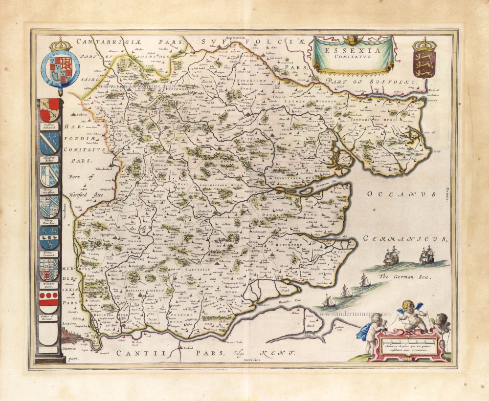
Essex, by J. Blaeu. 1646
Essexia Comitatus.
[Item number: 30234]

Glamorgan, by J. Blaeu. 1645
Glamorganensis Comitatus, Vulgo Glamorgan Shire.
[Item number: 25810]

Gloucester, by Joan Blaeu. 1662
Glocestria Ducatus; vulgo Glocester Shire
[Item number: 22813]

Hampshire by J. Blaeu. 1645
Hantonia Sive Southantonensis Comitatus Vulgo Hantshire.
[Item number: 29772]
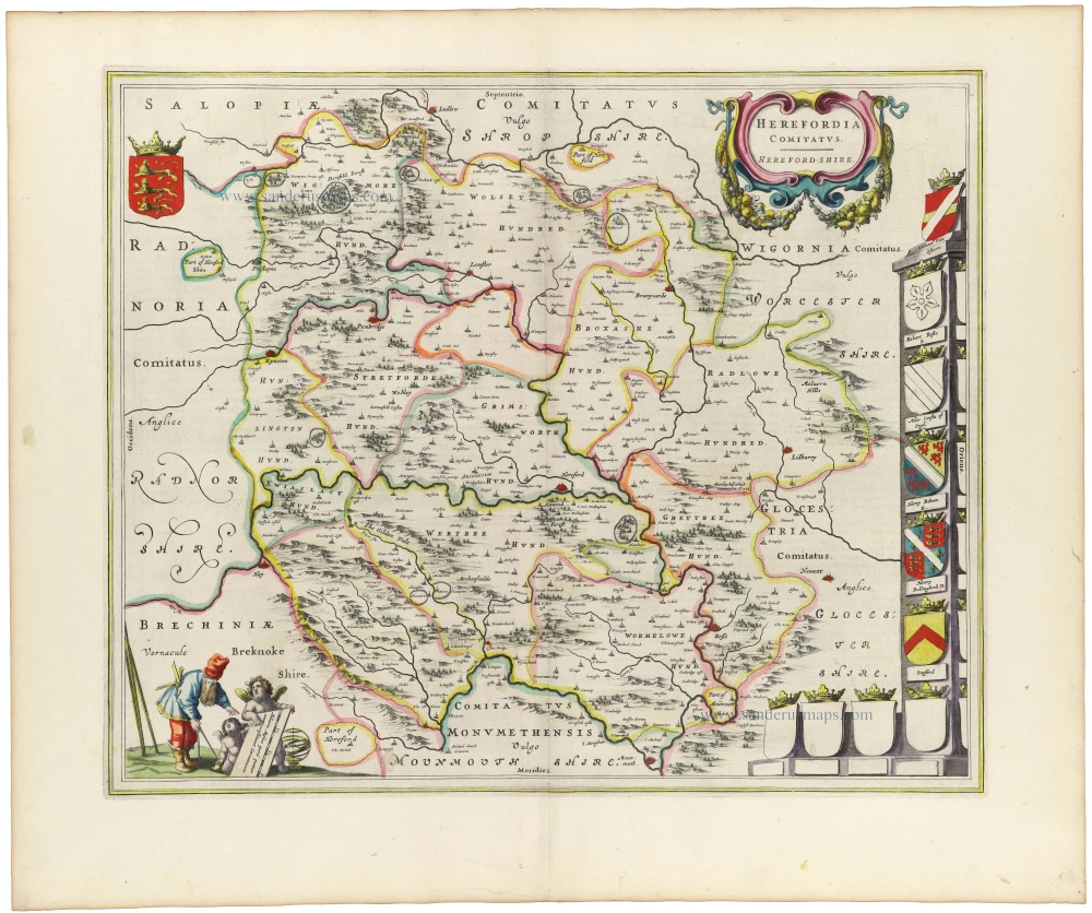
Hereford by Joan Blaeu 1645
Herefordia Comitatus. Hereford-Shire
[Item number: 33172]
new

Hertford by J. Blaeu. 1654-1662
Hertfordia Comitatus. Vernacule Hertfordshire.
[Item number: 8107]

Hertfordshire & Middlesex, by Johannes Janssonius. 1647
Middelsexiae, cum Hertfordiae Comitatu; Midlesex & Hertford...
[Item number: 809]

Holy Island, by Joan Blaeu. 1662
Insula Sacra; vulgo Holy Iland; et Farne
[Item number: 14300]

Huntington by J. Blaeu 1648
Huntingdonensis Comitatus - Huntington Shire.
[Item number: 20972]

Huntington, by Valk G. & Schenk P. c. 1700
Huntingdonensis Comitatus
[Item number: 1874]

Ireland, by Doncker H. 1686
De Noord-Oost zyde van Yerlandt van Caap de Hoorn-hout tot...
[Item number: 13644]

Ireland (Northwest), by Doncker H. 1686
Noord-west zyde van Yrlandt van C. de Hoorn to Slynhooft.
[Item number: 14899]

Ireland (Southwest), by Doncker H. 1686
De West Custen van Yrlandt van Corckbeg tot Slynhooft
[Item number: 13767]
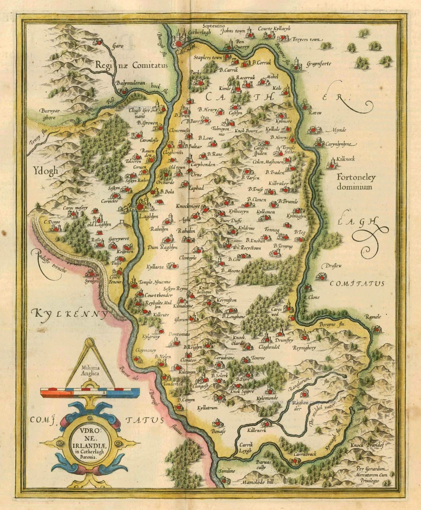
Ireland - Carlow by Mercator G. - Hondius J. 1628
Udrone Irlandiae in Catherlagh Baronia.
[Item number: 6474]

Ireland - Carlow by Gerard Mercator. 1641
Udrone Irlandiae in Caterlag Baronia.
[Item number: 26237]

Ireland - Carlow by Petrus Bertius, published by Jodocus Hondius II. 1618
Udrone.
[Item number: 31541]

Ireland - Connacht by Petrus Bertius, published by Jodocus Hondius II. 1618
Connatia. 1616.
[Item number: 31534]

Ireland - East Ulster, by Gerard Mercator. c. 1610-1650
Ultoniae Orientalis.
[Item number: 31110]

Ireland - Idrone by Joan Blaeu. 1654-1662
Baronia Udrone in Comitatu Catherloughae.
[Item number: 23155]

Ireland - Leinster by Petrus Bertius, published by Jodocus Hondius II. 1618
Lagenia.
[Item number: 31542]

Ireland - Meath by Petrus Bertius, published by Jodocus Hondius II. 1618
Media.
[Item number: 31535]
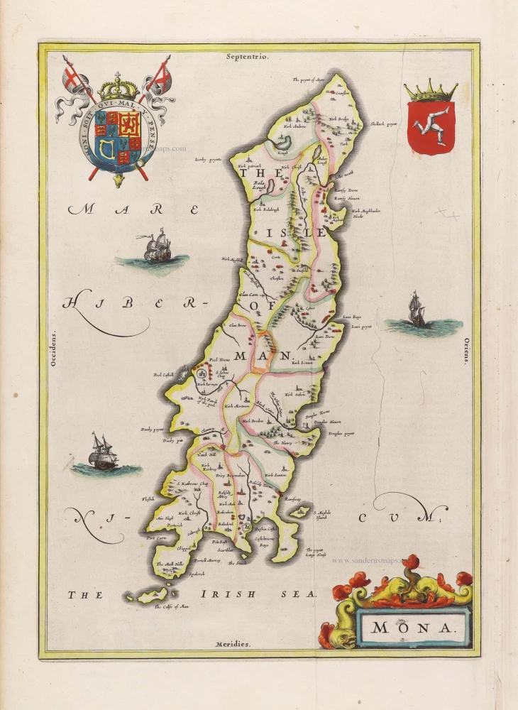
Isle of Man by Joan Blaeu. 1645
Mona.
[Item number: 29785]

Isle of Wight, by J. Blaeu. 1645
Vectis Insula Anglice. The Isle of Wight.
[Item number: 25754]

Sea chart of the Isle of Wight and adjacent mainland coastline, by Jacques Nicolas Bellin. 1762
Carte Reduite de l'Isle de Wight et Costes Voisines Depuis...
[Item number: 31426]
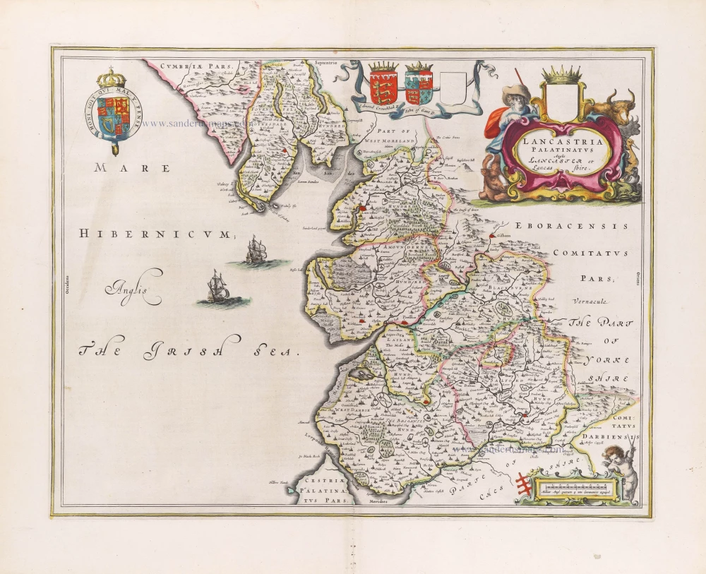
Lancashire, by Joan Blaeu. 1645
Lancastria Palatinatus Anglis Lancaster et Lancas Shire.
[Item number: 29783]
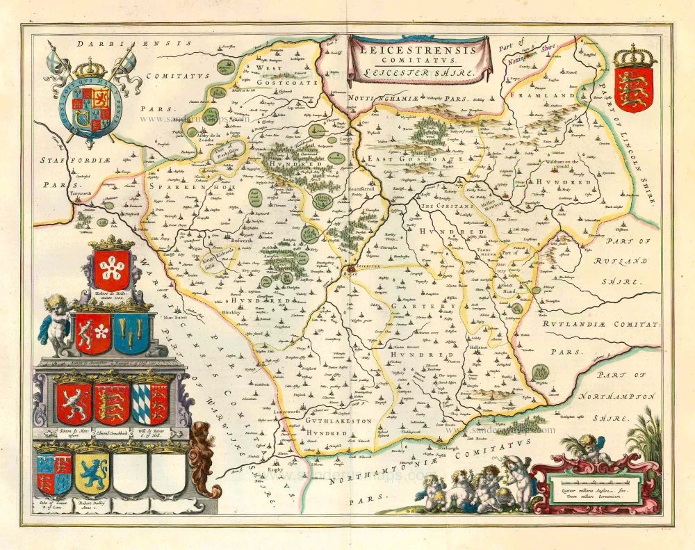
Leicester, by J. Blaeu. 1645
Leicestrensis Comitatus. Leicester Shire.
[Item number: 25801]
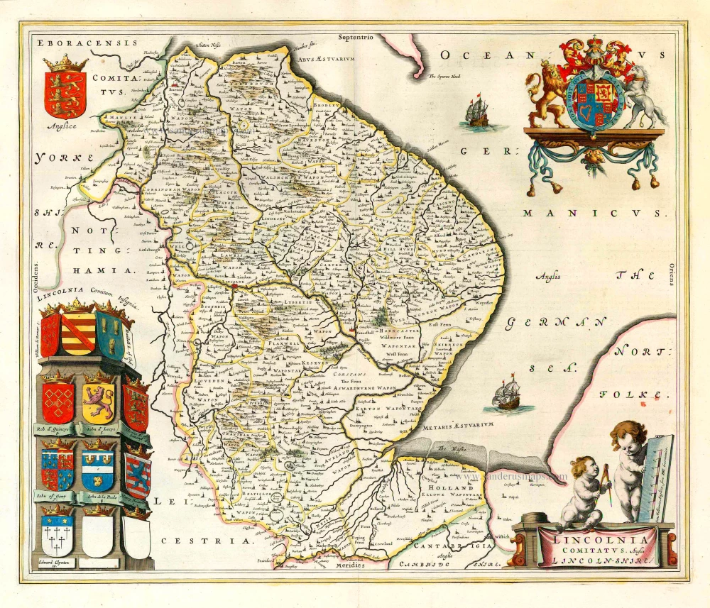
Lincolnshire, by J. Blaeu. 1645
Lincolnia Comitatus. Anglis Lincoln-shire.
[Item number: 25806]

London, by Covens & Mortier. 1721-41
Les Environs de Londres Ou se trouve toutte les Villes,...
[Item number: 23728]

Merioneth - Montgomery, by Janssonius J. c. 1650
Mervinia et Montgomeria Comitatus
[Item number: 13280]

Monmouth by J. Blaeu 1654-1662
Monumethensis Comitatus. Vernacule Monmouth Shire.
[Item number: 7060]

Montgomery and Merioneth, by Joan Blaeu. 1645
Montgomeria Comitatus et Comitatus Mervinia.
[Item number: 26728]

Northern Scotland, by Van Keulen Johannes. 1697-1709
Paskaart vande Noord Cust van Schotland als mede de Eylanden van...
[Item number: 5399]